
Shire of Irwin
Encyclopedia
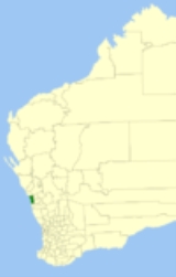
The Shire of Irwin is a Local Government Area
in the Mid West region of Western Australia
, about 50 kilometres (31 mi) south of Geraldton
and about 360 kilometres (224 mi) north of the state capital, Perth
. The Shire covers an area of 2374 square kilometres (917 sq mi), and its seat of government is the town of Dongara
.
and Three Springs
districts were split away from Irwin. On 1 July 1961, it became a Shire Council following changes to the Local Government Act.
Local Government Areas of Western Australia
The Australian state of Western Australia is divided into 141 local government areas...
in the Mid West region of Western Australia
Western Australia
Western Australia is a state of Australia, occupying the entire western third of the Australian continent. It is bounded by the Indian Ocean to the north and west, the Great Australian Bight and Indian Ocean to the south, the Northern Territory to the north-east and South Australia to the south-east...
, about 50 kilometres (31 mi) south of Geraldton
Geraldton, Western Australia
Geraldton is a city and port in Western Australia located north of Perth in the Mid West region. Geraldton has an estimated population at June 2010 of 36,958...
and about 360 kilometres (224 mi) north of the state capital, Perth
Perth, Western Australia
Perth is the capital and largest city of the Australian state of Western Australia and the fourth most populous city in Australia. The Perth metropolitan area has an estimated population of almost 1,700,000....
. The Shire covers an area of 2374 square kilometres (917 sq mi), and its seat of government is the town of Dongara
Dongara, Western Australia
Dongara is a town located 351 km north-northwest of Perth on the Brand Highway. The town is located at the mouth of the Irwin River. In recent years the area has been marketed as the 'Rock lobster capital of Australia'....
.
History
The Irwin Road District was created in 1871 as one of the first regional local government areas in Western Australia. On 16 June 1916, Irwin received a large land area from the Upper Irwin Road Board shortly before that entity's dissolution. In the 1920s, the CarnamahShire of Carnamah
The Shire of Carnamah is a Local Government Area located in the Mid West region of Western Australia, about north of Perth, the state capital, and about south of the city of Geraldton...
and Three Springs
Shire of Three Springs
The Shire of Three Springs is a Local Government Area in the Mid West region of Western Australia, about north of the state capital, Perth. The Shire covers an area of , and its seat of government is the town of Three Springs....
districts were split away from Irwin. On 1 July 1961, it became a Shire Council following changes to the Local Government Act.
| Year | Population |
|---|---|
| 1933 | 555 |
| 1947 | 465 |
| 1954 | 611 |
| 1961 | 657 |
| 1966 | 810 |
| 1971 | 941 |
| 1976 | 1,196 |
| 1981 | 1,578 |
| 1986 | 1,905 |
| 1991 | 2,100 |
| 1996 | 2,433 |
| 2001 | 2,810 |
| 2006 | 3,052 |
Wards
The shire is divided into 4 wards:- Denison Ward (4 councillors)
- North Ward (2 councillors)
- South East Ward (2 councillors)
- Town Ward (2 Councillors)
Towns and localities
- DongaraDongara, Western AustraliaDongara is a town located 351 km north-northwest of Perth on the Brand Highway. The town is located at the mouth of the Irwin River. In recent years the area has been marketed as the 'Rock lobster capital of Australia'....
- Allanooka
- ArrowsmithArrowsmith, Western AustraliaArrowsmith is a town in the Mid West region of Western Australia. Its local government area is the Shire of Irwin and it is located from the town of Dongara....
- Bookara
- Port DenisonPort Denison, Western AustraliaPort Denison is a town in the Mid West region of Western Australia. Its local government area is the Shire of Irwin and it is located southwest of Dongara on the Indian Ocean coast.-History:...
- Springfield
- Yardarino