
Shire of Carnamah
Encyclopedia
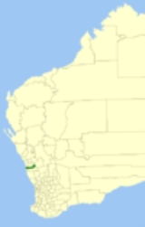
The Shire of Carnamah is a Local Government Area located in the Mid West region of Western Australia
, about 310 kilometres (193 mi) north of Perth
, the state capital, and about 115 kilometres (71 mi) south of the city of Geraldton
. The Shire covers an area of 2876 square kilometres (1,110 sq mi) and its seat of government is the town of Carnamah
.
and Mingenew
Road Boards on 24 August 1923. On 1 July 1961, it became a Shire under the Local Government Act 1960. On 19 April 1962, it lost three-fifths of its area when the Shire of Coorow was created.
Western Australia
Western Australia is a state of Australia, occupying the entire western third of the Australian continent. It is bounded by the Indian Ocean to the north and west, the Great Australian Bight and Indian Ocean to the south, the Northern Territory to the north-east and South Australia to the south-east...
, about 310 kilometres (193 mi) north of Perth
Perth, Western Australia
Perth is the capital and largest city of the Australian state of Western Australia and the fourth most populous city in Australia. The Perth metropolitan area has an estimated population of almost 1,700,000....
, the state capital, and about 115 kilometres (71 mi) south of the city of Geraldton
Geraldton, Western Australia
Geraldton is a city and port in Western Australia located north of Perth in the Mid West region. Geraldton has an estimated population at June 2010 of 36,958...
. The Shire covers an area of 2876 square kilometres (1,110 sq mi) and its seat of government is the town of Carnamah
Carnamah, Western Australia
Carnamah is a town in the Mid West region of Western Australia, about north of Perth along the Midlands Road. According to 2006 census, the population of the town is approximately 496....
.
History
The Carnamah Road District was formed out of land previously managed by the IrwinShire of Irwin
The Shire of Irwin is a Local Government Area in the Mid West region of Western Australia, about south of Geraldton and about north of the state capital, Perth. The Shire covers an area of , and its seat of government is the town of Dongara.-History:...
and Mingenew
Shire of Mingenew
The Shire of Mingenew is a Local Government Area in the Mid West region of Western Australia, about southeast of the city of Geraldton and about north of the state capital, Perth. The Shire covers an area of , and its seat of government is the town of Mingenew.On 18 September 2009, it was...
Road Boards on 24 August 1923. On 1 July 1961, it became a Shire under the Local Government Act 1960. On 19 April 1962, it lost three-fifths of its area when the Shire of Coorow was created.
Wards
The Shire has been divided into 4 wards.- Carnamah Ward (2 councillors)
- Eneabba Ward (2 councillors)
- Yarra Ward (2 councillors)
- Indoon Ward (1 councillor)
Population
| Year | Population |
|---|---|
| 1933 | 1,373 |
| 1947 | 1,025 |
| 1954 | 1,741 |
| 1961 | 1,701 |
| 1966 | 996 |
| 1971 | 925 |
| 1976 | 1,411 |
| 1981 | 1,245 |
| 1986 | 1,418 |
| 1991 | 1,148 |
| 1996 | 1,039 |
| 2001 | 850 |
| 2006 | 749 |