
Shire of Harvey
Encyclopedia
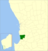
The Shire of Harvey is a Local Government Area
of Western Australia
. It is located in the state's South West region, approximately 140km south of Perth
, and includes some of Bunbury
's northern suburbs. The shire covers an area of 1,728 km² and has a estimated population of about 24,000. Around 12% of the population are of Southern or Eastern European origin.
It contains three large towns, Harvey
, Australind
and Brunswick Junction
and a number of smaller towns. The shire office is located on Uduc Road, Harvey, and an administration centre is open at Mulgara Street, Australind.
The ABS provides a breakdown for the Australind suburban area (Part A) and the remainder of the Shire (Part B):
Local Government Areas of Western Australia
The Australian state of Western Australia is divided into 141 local government areas...
of Western Australia
Western Australia
Western Australia is a state of Australia, occupying the entire western third of the Australian continent. It is bounded by the Indian Ocean to the north and west, the Great Australian Bight and Indian Ocean to the south, the Northern Territory to the north-east and South Australia to the south-east...
. It is located in the state's South West region, approximately 140km south of Perth
Perth, Western Australia
Perth is the capital and largest city of the Australian state of Western Australia and the fourth most populous city in Australia. The Perth metropolitan area has an estimated population of almost 1,700,000....
, and includes some of Bunbury
Bunbury, Western Australia
The port city of Bunbury is the third largest city in Western Australia after the State Capital Perth and Mandurah. It is situated south of Perth's central business district...
's northern suburbs. The shire covers an area of 1,728 km² and has a estimated population of about 24,000. Around 12% of the population are of Southern or Eastern European origin.
It contains three large towns, Harvey
Harvey, Western Australia
Harvey is a town located in the South West of Western Australia along the South Western Highway, 140 km south of Perth, between Pinjarra and Bunbury...
, Australind
Australind, Western Australia
Australind is a satellite town and outer northern suburb of Bunbury, Western Australia, and is located 12 km north-east of Bunbury's central business district. Its Local Government Area is the Shire of Harvey. At the 2006 census, Australind had a population of 8,717. -History:Prior to European...
and Brunswick Junction
Brunswick Junction, Western Australia
Brunswick Junction is a town located in the South West of Western Australia along the South Western Highway, between Harvey and Bunbury.-History:...
and a number of smaller towns. The shire office is located on Uduc Road, Harvey, and an administration centre is open at Mulgara Street, Australind.
History
From 1871, the Harvey district was controlled by the Wellington Road Board. The Brunswick Board was gazetted in December 1894 and the first election was held on 11 February 1895. It was not until 1909 that the name was changed to Harvey Road District. On 1 July 1961, it became the Shire of Harvey.Wards
The shire has been divided into 4 wards.- Central Ward (4 councillors)
- South Ward (2 councillors)
- Australind Ward (3 councillors)
- Coastal Ward (1 councillor)
Towns and localities
The Shire of Harvey contains the following towns and localities:
|
Harvey, Western Australia Harvey is a town located in the South West of Western Australia along the South Western Highway, 140 km south of Perth, between Pinjarra and Bunbury... Kemerton, Western Australia Kemerton is an industrial park in the Bunbury region of Western Australia, about 10km north-east of Australind. Its Local Government Area is the Shire of Harvey.-Description:... Leschenault, Western Australia Leschenault is an outer suburb of Bunbury, Western Australia, and is located 16 km to the north-east. Its Local Government Area is the Shire of Harvey.-History:... Myalup, Western Australia Myalup is a town located on the coast in the South West region of Western Australia between Mandurah and Bunbury. At the 2006 census, Myalup had a population of 144.-History:... |
Roelands, Western Australia Roelands is a town located in the South West region of Western Australia along the South Western Highway, between Brunswick Junction and Bunbury... Uduc, Western Australia Uduc is a town located in the South West of Western Australia between Harvey and the Indian Ocean coast at Myalup. It is an agricultural district and was first settled by William Crampton between 1844 and 1860.... Wokalup, Western Australia Wokalup is a town located in the South West region of Western Australia along the South Western Highway, between Harvey and Brunswick Junction. At the 2006 census, Wokalup had a population of 449.... Yarloop, Western Australia Yarloop is a town located in the South West of Western Australia along the South Western Highway, between Waroona and Harvey. At the 2006 census, Yarloop had a population of 545.-History:... |
Population
| Year | Population |
|---|---|
| 1911 | 3,646 |
| 1921 | 3,950 |
| 1933 | 5,367 |
| 1947 | 5,589 |
| 1954 | 6,731 |
| 1961 | 6,834 |
| 1966 | 6,543 |
| 1971 | 6,460 |
| 1976 | 6,704 |
| 1981 | 8,027 |
| 1986 | 9,609 |
| 1991 | 12,367 |
| 1996 | 14,714 |
| 2001 | 17,224 |
| 2006 | 19,556 |
The ABS provides a breakdown for the Australind suburban area (Part A) and the remainder of the Shire (Part B):
| Year | Part A | Part B |
|---|---|---|
| 1991 | 5,816 | 6,551 |
| 1996 | 7,570 | 7,144 |
| 2001 | 9,574 | 7,650 |
| 2006 | 11,537 | 8,019 |