
Thomas County, Kansas
Encyclopedia
Thomas County is a county
located in the U.S. state
of Kansas
. As of the 2010 census, the county population was 7,900. Its county seat
is Colby
.
, county until the Kansas Constitution was amended in 1986 and voters approved the sale of alcoholic liquor by the individual drink with a 30% food sales requirement.
 As of the census
of 2000, there were 8,180 people, 3,226 households, and 2,125 families residing in the county. The population density
was 8 people per square mile (3/km²). There were 3,562 housing units at an average density of 3 per square mile (1/km²). The racial makeup of the county was 97.14% White
, 0.43% Black
or African American
, 0.33% Native American
, 0.27% Asian
, 0.02% Pacific Islander
, 0.95% from other races
, and 0.86% from two or more races. 1.85% of the population were Hispanic
or Latino
of any race.
There were 3,226 households out of which 32.90% had children under the age of 18 living with them, 56.10% were married couples
living together, 6.90% had a female householder with no husband present, and 34.10% were non-families. 28.40% of all households were made up of individuals and 11.70% had someone living alone who was 65 years of age or older. The average household size was 2.45 and the average family size was 3.04.
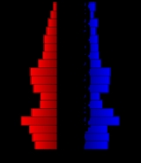
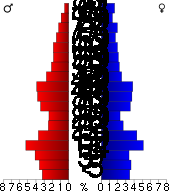
In the county the population was spread out with 26.30% under the age of 18, 13.50% from 18 to 24, 24.40% from 25 to 44, 21.20% from 45 to 64, and 14.60% who were 65 years of age or older. The median age was 35 years. For every 100 females there were 94.60 males. For every 100 females age 18 and over, there were 91.50 males.
The median income for a household in the county was $37,034, and the median income for a family was $45,931. Males had a median income of $33,833 versus $21,310 for females. The per capita income
for the county was $19,028. About 6.60% of families and 9.70% of the population were below the poverty line, including 5.90% of those under age 18 and 7.50% of those age 65 or over.
. The city of Colby
is considered governmentally independent and is excluded from the census figures for the townships. Geographically, Colby is surrounded by Morgan Township. In the following table, the population center is the largest city (or cities) included in that township's population total, if it is of a significant size.
General Information
Kansas County Data
Thomas County local history and genealogy
Maps
County (United States)
In the United States, a county is a geographic subdivision of a state , usually assigned some governmental authority. The term "county" is used in 48 of the 50 states; Louisiana is divided into parishes and Alaska into boroughs. Parishes and boroughs are called "county-equivalents" by the U.S...
located in the U.S. state
U.S. state
A U.S. state is any one of the 50 federated states of the United States of America that share sovereignty with the federal government. Because of this shared sovereignty, an American is a citizen both of the federal entity and of his or her state of domicile. Four states use the official title of...
of Kansas
Kansas
Kansas is a US state located in the Midwestern United States. It is named after the Kansas River which flows through it, which in turn was named after the Kansa Native American tribe, which inhabited the area. The tribe's name is often said to mean "people of the wind" or "people of the south...
. As of the 2010 census, the county population was 7,900. Its county seat
County seat
A county seat is an administrative center, or seat of government, for a county or civil parish. The term is primarily used in the United States....
is Colby
Colby, Kansas
Colby is a city in and the county seat of Thomas County, Kansas, United States. As of the 2010 census, the city population was 5,387.-History:...
.
Law and government
Thomas County was a prohibition, or "dry"Dry county
A dry county is a county in the United States whose government forbids the sale of alcoholic beverages. Some prohibit off-premises sale, some prohibit on-premises sale, and some prohibit both. Hundreds of dry counties exist across the United States, almost all of them in the South...
, county until the Kansas Constitution was amended in 1986 and voters approved the sale of alcoholic liquor by the individual drink with a 30% food sales requirement.
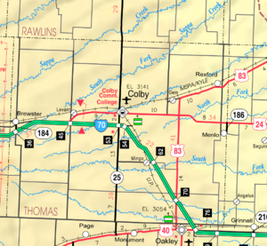
Geography
According to the 2000 census, the county has a total area of 1074.9 square miles (2,784 km²), of which 1074.78 square miles (2,783.7 km²) (or 99.99%) is land and 0.11 square mile (0.2848986921 km²) (or 0.01%) is water.Adjacent counties
- Rawlins CountyRawlins County, KansasRawlins County is a county located in the U.S. state of Kansas. As of the 2010 census, the county population was 2,519. The largest city and county seat is Atwood...
(north) - Decatur CountyDecatur County, KansasDecatur County is a county located in Northwest Kansas, in the Central United States. As of the 2010 census, the county population was 2,961. Its county seat and most populous city is Oberlin. The county is named in honor of Commodore Stephen Decatur, Jr.-History:The county was established...
(northeast) - Sheridan CountySheridan County, KansasSheridan County is a county located in the U.S. state of Kansas. As of the 2010 census, the county population was 2,556. Its county seat is Hoxie. The county was named in honor of Phillip H...
(east) - Gove CountyGove County, KansasGove County is a county located in Northwest Kansas, in the Central United States. As of the 2010 census, the county population was 2,695...
(southeast) - Logan CountyLogan County, KansasLogan County is a county located in the U.S. state of Kansas. As of the 2010 census, the county population was 2,756...
(south) - Sherman CountySherman County, KansasSherman County is a county located in the U.S. state of Kansas. As of the 2010 census, the county population was 6,010...
(west)
Demographics
Census
A census is the procedure of systematically acquiring and recording information about the members of a given population. It is a regularly occurring and official count of a particular population. The term is used mostly in connection with national population and housing censuses; other common...
of 2000, there were 8,180 people, 3,226 households, and 2,125 families residing in the county. The population density
Population density
Population density is a measurement of population per unit area or unit volume. It is frequently applied to living organisms, and particularly to humans...
was 8 people per square mile (3/km²). There were 3,562 housing units at an average density of 3 per square mile (1/km²). The racial makeup of the county was 97.14% White
Race (United States Census)
Race and ethnicity in the United States Census, as defined by the Federal Office of Management and Budget and the United States Census Bureau, are self-identification data items in which residents choose the race or races with which they most closely identify, and indicate whether or not they are...
, 0.43% Black
Race (United States Census)
Race and ethnicity in the United States Census, as defined by the Federal Office of Management and Budget and the United States Census Bureau, are self-identification data items in which residents choose the race or races with which they most closely identify, and indicate whether or not they are...
or African American
Race (United States Census)
Race and ethnicity in the United States Census, as defined by the Federal Office of Management and Budget and the United States Census Bureau, are self-identification data items in which residents choose the race or races with which they most closely identify, and indicate whether or not they are...
, 0.33% Native American
Race (United States Census)
Race and ethnicity in the United States Census, as defined by the Federal Office of Management and Budget and the United States Census Bureau, are self-identification data items in which residents choose the race or races with which they most closely identify, and indicate whether or not they are...
, 0.27% Asian
Race (United States Census)
Race and ethnicity in the United States Census, as defined by the Federal Office of Management and Budget and the United States Census Bureau, are self-identification data items in which residents choose the race or races with which they most closely identify, and indicate whether or not they are...
, 0.02% Pacific Islander
Race (United States Census)
Race and ethnicity in the United States Census, as defined by the Federal Office of Management and Budget and the United States Census Bureau, are self-identification data items in which residents choose the race or races with which they most closely identify, and indicate whether or not they are...
, 0.95% from other races
Race (United States Census)
Race and ethnicity in the United States Census, as defined by the Federal Office of Management and Budget and the United States Census Bureau, are self-identification data items in which residents choose the race or races with which they most closely identify, and indicate whether or not they are...
, and 0.86% from two or more races. 1.85% of the population were Hispanic
Race (United States Census)
Race and ethnicity in the United States Census, as defined by the Federal Office of Management and Budget and the United States Census Bureau, are self-identification data items in which residents choose the race or races with which they most closely identify, and indicate whether or not they are...
or Latino
Race (United States Census)
Race and ethnicity in the United States Census, as defined by the Federal Office of Management and Budget and the United States Census Bureau, are self-identification data items in which residents choose the race or races with which they most closely identify, and indicate whether or not they are...
of any race.
There were 3,226 households out of which 32.90% had children under the age of 18 living with them, 56.10% were married couples
Marriage
Marriage is a social union or legal contract between people that creates kinship. It is an institution in which interpersonal relationships, usually intimate and sexual, are acknowledged in a variety of ways, depending on the culture or subculture in which it is found...
living together, 6.90% had a female householder with no husband present, and 34.10% were non-families. 28.40% of all households were made up of individuals and 11.70% had someone living alone who was 65 years of age or older. The average household size was 2.45 and the average family size was 3.04.
In the county the population was spread out with 26.30% under the age of 18, 13.50% from 18 to 24, 24.40% from 25 to 44, 21.20% from 45 to 64, and 14.60% who were 65 years of age or older. The median age was 35 years. For every 100 females there were 94.60 males. For every 100 females age 18 and over, there were 91.50 males.
The median income for a household in the county was $37,034, and the median income for a family was $45,931. Males had a median income of $33,833 versus $21,310 for females. The per capita income
Per capita income
Per capita income or income per person is a measure of mean income within an economic aggregate, such as a country or city. It is calculated by taking a measure of all sources of income in the aggregate and dividing it by the total population...
for the county was $19,028. About 6.60% of families and 9.70% of the population were below the poverty line, including 5.90% of those under age 18 and 7.50% of those age 65 or over.
Incorporated cities
Name and population (2004 estimate):- ColbyColby, KansasColby is a city in and the county seat of Thomas County, Kansas, United States. As of the 2010 census, the city population was 5,387.-History:...
, 5,145 (county seat) - BrewsterBrewster, KansasBrewster is a city in Thomas County, Kansas, United States. As of the 2010 census, the city population was 305.-Geography:Brewster is located at . According to the United States Census Bureau, the city has a total area of , all of it land.-Demographics:As of the census of 2000, there were 285...
, 268 - RexfordRexford, KansasRexford is a city in Thomas County, Kansas, United States. As of the 2010 census, the city population was 232.-Geography:Rexford is located at . According to the United States Census Bureau, the city has a total area of , all of it land.-Demographics:As of the census of 2000, there were 157...
, 153 - GemGem, KansasGem is a city in Thomas County, Kansas, United States. As of the 2010 census, the city population was 88.-Geography:Gem is located at . According to the United States Census Bureau, the city has a total area of , all of it land....
, 93 - MenloMenlo, KansasMenlo is a city in Thomas County, Kansas, United States. As of the 2010 census, the city population was 61.-Geography:Menlo is located at . According to the United States Census Bureau, the city has a total area of , all of it land....
, 56 - OakleyOakley, KansasOakley is a city in Gove, Logan, and Thomas counties in the U.S. state of Kansas. As of the 2010 census, the city population was 2,045. It is the county seat of Logan County.-Geography:...
(only a small portion)
Townships
Thomas County is divided into thirteen townshipsCivil township
A civil township is a widely used unit of local government in the United States, subordinate to, and geographic divisions of, a county. Specific responsibilities and the degree of autonomy vary based on each state. Civil townships are distinct from survey townships, but in states that have both,...
. The city of Colby
Colby, Kansas
Colby is a city in and the county seat of Thomas County, Kansas, United States. As of the 2010 census, the city population was 5,387.-History:...
is considered governmentally independent and is excluded from the census figures for the townships. Geographically, Colby is surrounded by Morgan Township. In the following table, the population center is the largest city (or cities) included in that township's population total, if it is of a significant size.
| Township | FIPS | Population center |
Population | Population density /km² (/sq mi) |
Land area km² (sq mi) | Water area km² (sq mi) | Water % | Geographic coordinates |
|---|---|---|---|---|---|---|---|---|
| Barrett | 04325 | 124 | 0 (1) | 276 (107) | 0 (0) | 0.01% | 39°30′21"N 101°16′7"W | |
| East Hale | 19475 | 137 | 1 (3) | 140 (54) | 0 (0) | 0 % | 39°22′27"N 101°12′49"W | |
| Kingery | 36925 | 93 | 0 (1) | 373 (144) | 0 (0) | 0 % | 39°13′55"N 101°16′52"W | |
| Lacey | 37425 | Gem Gem, Kansas Gem is a city in Thomas County, Kansas, United States. As of the 2010 census, the city population was 88.-Geography:Gem is located at . According to the United States Census Bureau, the city has a total area of , all of it land.... |
132 | 1 (4) | 92 (36) | 0 (0) | 0 % | 39°25′48"N 100°53′27"W |
| Menlo | 45775 | Menlo Menlo, Kansas Menlo is a city in Thomas County, Kansas, United States. As of the 2010 census, the city population was 61.-Geography:Menlo is located at . According to the United States Census Bureau, the city has a total area of , all of it land.... |
112 | 1 (2) | 140 (54) | 0 (0) | 0 % | 39°20′36"N 100°46′4"W |
| Morgan | 48200 | Colby Colby, Kansas Colby is a city in and the county seat of Thomas County, Kansas, United States. As of the 2010 census, the city population was 5,387.-History:... outskirts |
755 | 3 (7) | 271 (105) | 0 (0) | 0 % | 39°22′31"N 101°3′0"W |
| North Randall | 51300 | 107 | 1 (2) | 138 (53) | 0 (0) | 0.03% | 39°19′44"N 100°53′55"W | |
| Rovohl | 61525 | 143 | 1 (1) | 277 (107) | 0 (0) | 0 % | 39°30′11"N 101°4′3"W | |
| Smith | 65900 | Rexford Rexford, Kansas Rexford is a city in Thomas County, Kansas, United States. As of the 2010 census, the city population was 232.-Geography:Rexford is located at . According to the United States Census Bureau, the city has a total area of , all of it land.-Demographics:As of the census of 2000, there were 157... |
213 | 2 (6) | 93 (36) | 0 (0) | 0.03% | 39°27′11"N 100°45′31"W |
| South Randall | 66875 | Oakley Oakley, Kansas Oakley is a city in Gove, Logan, and Thomas counties in the U.S. state of Kansas. As of the 2010 census, the city population was 2,045. It is the county seat of Logan County.-Geography:... outskirts |
267 | 1 (2) | 279 (108) | 0 (0) | 0.04% | 39°10′59"N 100°50′29"W |
| Summers | 68975 | 197 | 1 (1) | 373 (144) | 0 (0) | 0 % | 39°14′30"N 101°2′47"W | |
| Wendell | 76650 | 84 | 0 (1) | 183 (71) | 0 (0) | 0.02% | 39°31′4"N 100°49′21"W | |
| West Hale | 76975 | Brewster Brewster, Kansas Brewster is a city in Thomas County, Kansas, United States. As of the 2010 census, the city population was 305.-Geography:Brewster is located at . According to the United States Census Bureau, the city has a total area of , all of it land.-Demographics:As of the census of 2000, there were 285... |
366 | 3 (7) | 140 (54) | 0 (0) | 0 % | 39°21′50"N 101°21′48"W |
Education
Unified school districts
Further reading
- History of the State of Kansas; William G. Cutler; A.T. Andreas Publisher; 1883. (Online HTML eBook)
- Kansas : A Cyclopedia of State History, Embracing Events, Institutions, Industries, Counties, Cities, Towns, Prominent Persons, Etc; 3 Volumes; Frank W. Blackmar; Standard Publishing Co; 944 / 955 / 824 pages; 1912. (Volume1 - Download 54MB PDF eBook),(Volume2 - Download 53MB PDF eBook), (Volume3 - Download 33MB PDF eBook)
External links
OfficialGeneral Information
Kansas County Data
Thomas County local history and genealogy
Maps
- Thomas County Map, KDOT
- Kansas Highway Map, KDOT
- Kansas Railroad Map, KDOT
- Kansas School District Boundary Map, KSDE