

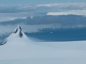
Sharp Peak, Livingston Island
Encyclopedia
Vidin Heights
Vidin Heights are predominantly ice-covered heights rising to 604 m on Varna Peninsula, eastern Livingston Island in the South Shetland Islands, Antarctica. The feature is approximately 8 km long from the north end of Leslie Gap east-northeastwards to Inott Point and 9.6 km...
on Varna Peninsula
Varna Peninsula
Varna Peninsula is a roughly rectangular predominantly ice-covered peninsula forming the northeast extremity of Livingston Island in the South Shetland Islands, Antarctica...
, Livingston Island in the South Shetland Islands
South Shetland Islands
The South Shetland Islands are a group of Antarctic islands, lying about north of the Antarctic Peninsula, with a total area of . By the Antarctic Treaty of 1959, the Islands' sovereignty is neither recognized nor disputed by the signatories and they are free for use by any signatory for...
, Antarctica. The peak is surmounting Rose Valley Glacier
Rose Valley Glacier
Rose Valley Glacier is a glacier on Varna Peninsula, eastern Livingston Island in the South Shetland Islands, Antarctica extending 5.2 km in southeast-northwest direction, and 3.7 km in southwest-northeast direction...
to the northwest and Debelt Glacier
Debelt Glacier
The Debelt Glacier sits on Varna Peninsula, Livingston Island draining the southeastern slopes of Vidin Heights into Moon Bay between Edinburgh Hill and Helis Nunatak...
to the south.
The feature was named descriptively in a 1935 British chart.
Location
The peak is located at 62°31′25.2"S 60°04′09.3"W which is 2.38 km south by west of Karavelova PointKaravelova Point
Karavelova Point or Nos Karavelova , translator, author and woman activist.-Location:The point is located at which is 2.1 km south of Pomorie Point, 7 km southeast of Williams Point and 3.6 km northwest of Inott Point.-Maps:...
, 3.28 km west of Inott Point
Inott Point
Inott Point is a point 1.1 mile north-northeast of Edinburgh Hill on the east coast of Livingston Island in the South Shetland Islands, Antarctica...
, 3.28 km northwest of Edinburgh Hill
Edinburgh Hill
Edinburgh Hill is a narrow point projecting 650 m from the east coast of Varna Peninsula, Livingston Island in the South Shetland Islands, Antarctica into McFarlane Strait and ending up in a conspicuous rocky hill of elevation 180 m. The point forms the northwest side of the entrance to Moon Bay...
, 1.9 km north by east of Helis Nunatak
Helis Nunatak
Helis Nunatak is a crown-shaped rocky peak of elevation 340 m in Vidin Heights on Varna Peninsula, Livingston Island in the South Shetland Islands, Western Antarctica...
, 3.73 km northeast of Samuel Peak
Samuel Peak
Samuel Peak is the 540 m peak in central Vidin Heights, Livingston Island in the South Shetland Islands, Antarctica. Surmounting Panega Glacier to the east and Kaliakra Glacier to the south....
and 5.08 km east-northeast of Miziya Peak
Miziya Peak
Miziya Peak is the 604 m summit of Vidin Heights on Varna Peninsula, eastern Livingston Island in the South Shetland Islands, Antarctica...
(British survey in 1957-59 and mapping in 1968, Spanish mapping in 1991, and Bulgarian in 2005 and 2009).
Maps
- L.L. Ivanov et al. Antarctica: Livingston Island and Greenwich Island, South Shetland Islands. Scale 1:100000 topographic map. Sofia: Antarctic Place-names Commission of Bulgaria, 2005.
- L.L. Ivanov. Antarctica: Livingston Island and Greenwich, Robert, Snow and Smith Islands. Scale 1:120000 topographic map. Troyan: Manfred Wörner Foundation, 2009. ISBN 978-954-92032-6-4