
Shardlow
Encyclopedia
Derbyshire
Derbyshire is a county in the East Midlands of England. A substantial portion of the Peak District National Park lies within Derbyshire. The northern part of Derbyshire overlaps with the Pennines, a famous chain of hills and mountains. The county contains within its boundary of approx...
, England
England
England is a country that is part of the United Kingdom. It shares land borders with Scotland to the north and Wales to the west; the Irish Sea is to the north west, the Celtic Sea to the south west, with the North Sea to the east and the English Channel to the south separating it from continental...
about 8 km southeast of Derby
Derby
Derby , is a city and unitary authority in the East Midlands region of England. It lies upon the banks of the River Derwent and is located in the south of the ceremonial county of Derbyshire. In the 2001 census, the population of the city was 233,700, whilst that of the Derby Urban Area was 229,407...
and 12 km southwest of Nottingham
Nottingham
Nottingham is a city and unitary authority in the East Midlands of England. It is located in the ceremonial county of Nottinghamshire and represents one of eight members of the English Core Cities Group...
. It is part of the civil parish
Civil parish
In England, a civil parish is a territorial designation and, where they are found, the lowest tier of local government below districts and counties...
of Shardlow and Great Wilne
Shardlow and Great Wilne
Shardlow and Great Wilne is a civil parish in the South Derbyshire district of the English county of Derbyshire.Shardlow and Great Wilne are the main settlements in the parish....
, and the district of South Derbyshire
South Derbyshire
South Derbyshire is a local government district in Derbyshire, England. It contains a third of the National Forest, and the council offices are in Swadlincote....
. It is also very close to the border with Leicestershire
Leicestershire
Leicestershire is a landlocked county in the English Midlands. It takes its name from the heavily populated City of Leicester, traditionally its administrative centre, although the City of Leicester unitary authority is today administered separately from the rest of Leicestershire...
which follows the River Trent
River Trent
The River Trent is one of the major rivers of England. Its source is in Staffordshire on the southern edge of Biddulph Moor. It flows through the Midlands until it joins the River Ouse at Trent Falls to form the Humber Estuary, which empties into the North Sea below Hull and Immingham.The Trent...
, passing close by the south of the village. Just across the Trent is the Castle Donington
Castle Donington
Castle Donington is a village, with a population of around 7000 in the North West of Leicestershire, part of the Derby postcode area and on the edge of the National Forest. It is the closest town to East Midlands Airport.-Transport and housing:...
parish of North West Leicestershire
North West Leicestershire
North West Leicestershire is a local government district in Leicestershire, England. Its main towns are Ashby-de-la-Zouch and Coalville.The district contains East Midlands Airport, which operates flights to the rest of Britain and to various places in Europe...
.
History
Early evidence of human activity dated back to 1500 bce. A Bronze Age log boatHanson Log Boat
The Hanson Log Boat was a bronze age boat found in a gravel pit in Shardlow in Derbyshire. This log boat is now in Derby Museum and Art Gallery.-Description:...
was discovered at the Hanson gravel pit nearby. Sadly the boat had to be sawn into small sections so that it could be transported and conserved. The boat is now in Derby Museum and Art Gallery
Derby Museum and Art Gallery
Derby Museum and Art Gallery was established in 1879, along with Derby Central Library, in a new building designed by Richard Knill Freeman and given to Derby by Michael Thomas Bass. The collection includes a whole gallery displaying the paintings of Joseph Wright of Derby; there is also a large...
.
In 1009 Æþelræd Unræd
Ethelred the Unready
Æthelred the Unready, or Æthelred II , was king of England . He was son of King Edgar and Queen Ælfthryth. Æthelred was only about 10 when his half-brother Edward was murdered...
(King Ethelred the Unready) signed a charter at the Great Council which recognised the position and boundaries of Westune
Weston-on-Trent
Weston-on-Trent is a village and civil parish in the South Derbyshire district of Derbyshire. It is to the north of the River Trent and the Trent and Mersey Canal. Nearby places include Aston-on-Trent, Barrow upon Trent, Castle Donington and Swarkestone....
. The land described in that charter included the lands now known as Shardlow, Great Wilne
Great Wilne
Great Wilne is a small village in Derbyshire, England on the border with Leicestershire. It is 7 miles south east of Derby. It is a village split from its church of St Chads by the river...
, Church Wilne, Crich
Crich
Crich is a village in Derbyshire in England. It has the National Tramway Museum inside the Crich Tramway Village, and at the summit of Crich Hill above, a Memorial Tower for those of the Sherwood Foresters regiment who died in battle, particularly in World War I.Built in 1923 on the site of an...
, Smalley
Smalley, Derbyshire
Smalley is a village on the main A608 Heanor to Derby road in Derbyshire in the East Midlands of England.Its name came from Anglo-Saxon Smæl-lēah = "narrow woodland clearing"...
, Morley
Morley, Derbyshire
Morley is a civil parish within the area of Erewash Borough Council in the English county of Derbyshire, north of Derby It is on the eastern side of Morley Moor, with Morley Smithy to the north. The parish church of St Matthew stands near the Tithe Barn and dovecote of Morley Hall...
, Weston and Aston-on-Trent
Aston-on-Trent
Aston-on-Trent is a Derbyshire village, situated in the English East Midlands, near Derby. It is adjacent to Weston-on-Trent and is near to Chellaston. It is very close to the border with Leicestershire....
. Under this charter Æþelræd gave his minister a number of rights that made him free from tax
Trinoda necessitas
Trinoda necessitas is a Latin term used to refer to a "threefold tax" in Anglo-Saxon times. Subjects of an Anglo-Saxon king were required to yield three services: bridge-bote , burgh-bote , and fyrd-bote...
and to his own rule within the manor.
The London to Manchester turnpike (now the A6) passes through, having crossed the river by means of rope-hauled boat at Wilden Ferry. In 1761 the Cavendish Bridge was opened as a toll bridge. In 1947 it washed away and the army provided a temporary Bailey Bridge
Bailey bridge
The Bailey bridge is a type of portable, pre-fabricated, truss bridge. It was developed by the British during World War II for military use and saw extensive use by both British and the American military engineering units....
, which was replaced by the present structure in 1957.
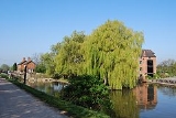
The river is navigable as far as the sea at the Humber Estuary
Humber
The Humber is a large tidal estuary on the east coast of Northern England. It is formed at Trent Falls, Faxfleet, by the confluence of the tidal River Ouse and the tidal River Trent. From here to the North Sea, it forms part of the boundary between the East Riding of Yorkshire on the north bank...
, as is the River Soar
River Soar
The River Soar is a tributary of the River Trent in the English East Midlands.-Description:It rises near Hinckley in Leicestershire and is joined by the River Sence near Enderby before flowing through Leicester , Barrow-on-Soar, beside Loughborough and Kegworth, before joining the Trent near...
which joins it some two miles down. It had always been an important trading highway and, with the crossing of the turnpike had, by the 18th Century become a river port.
In 1770, James Brindley
James Brindley
James Brindley was an English engineer. He was born in Tunstead, Derbyshire, and lived much of his life in Leek, Staffordshire, becoming one of the most notable engineers of the 18th century.-Early life:...
brought the Trent and Mersey Canal
Trent and Mersey Canal
The Trent and Mersey Canal is a in the East Midlands, West Midlands, and North West of England. It is a "narrow canal" for the vast majority of its length, but at the extremities—east of Burton upon Trent and west of Middlewich—it is a wide canal....
through the village to join the River Trent
River Trent
The River Trent is one of the major rivers of England. Its source is in Staffordshire on the southern edge of Biddulph Moor. It flows through the Midlands until it joins the River Ouse at Trent Falls to form the Humber Estuary, which empties into the North Sea below Hull and Immingham.The Trent...
at Great Wilne
Great Wilne
Great Wilne is a small village in Derbyshire, England on the border with Leicestershire. It is 7 miles south east of Derby. It is a village split from its church of St Chads by the river...
at the junction of the Derwent
River Derwent, Derbyshire
The Derwent is a river in the county of Derbyshire, England. It is 66 miles long and is a tributary of the River Trent which it joins south of Derby. For half its course, the river flows through the Peak District....
which was also, up to a point, navigable. Shardlow thus grew rapidly as a transshipment
Transshipment
Transshipment or Transhipment is the shipment of goods or containers to an intermediate destination, and then from there to yet another destination....
point, not only for road vehicles, but between the broad river barges and Brindley's canal narrow boats.
Two families made their fortunes, the Soresburys with rapid horse-drawn 'fly boats' on the Trent, and the Sutton
James Sutton (Shardlow)
James Sutton was an English boatbuilder, canal boat carrier and owner of salt works. He became High Sheriff of Derbyshire....
s with their barges and narrow boats. The population rose from three hundred to over a thousand but, in the 1840s the arrival of the railways signalled the beginning of the end.
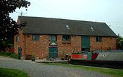
Most of the warehouses and other buildings were converted to other uses or as private dwellings. What is left has been preserved as the Shardlow Wharf Conservation Area, including a milepost inscribed "Preston Brook 92 miles." Shardlow and Great Wilne had been included in the parish of Aston-on-Trent until 1838, when Shardlow constructed its own church.
The small village is home to a vast selection of public houses which include The Shakespeare, The Dog & Duck, The Clock Warehouse, The Navigation, The Old Crown, The New Inn, and the Malt Shovel
See also
Cavendish BridgeCavendish Bridge
Cavendish Bridge is the name of a bridge over the River Trent, and a hamlet, on the border between Leicestershire and Derbyshire. It once carried the main London-Manchester turnpike, though a modern dual carriageway has now been built to the south bypassing the location.-History:Before the bridge...
, King's Mill
King's Mill, Castle Donington
King's Mill is the traditional crossing point of the River Trent between Castle Donington in Leicestershire and Weston-on-Trent in Derbyshire. The Mill was the farthest point that traffic from the River Humber could progress. A lock was installed here to make the river navigable but the business...
, Shardlow Hall (school)
Shardlow Hall (school)
* For the 17th century country house see Shardlow Hall, DerbyshireShardlow Hall was a school in Shardlow, a village seven miles south of Derby in the English Midlands. It was founded by B.O.Corbett, who had played football for England, as a preparatory school for boys...
, Shardlow Hall