
Shalalth, British Columbia
Encyclopedia
Shalalth, pop. c. 400, is one of the main communities of the Seton Lake
Band of the St'at'imc (Lillooet) Nation
and location of the two main powerhouses of the Bridge River Power Project
.
The word Shalalth ' onMouseout='HidePop("27984")' href="/topics/St'at'imcets_language">St'at'imcets
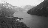
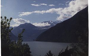
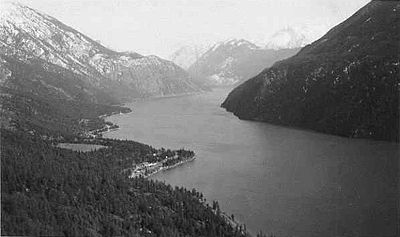
, the Lillooet language) means simply "lake" or, particularly, the lake, meaning Seton Lake
, a freshwater fjord
stretching twenty miles through a desert canyon westwards from the Fraser River
at Lillooet
.
and Whistler
via the port, railway and logging town of Squamish
to Vancouver. Located on the portage is the neighbouring community of Seton Portage
, which contains the other main communities of the Seton Lake Band
of the St'at'imc Nation
plus a mix of residential and resort homes owned by non-natives (pop. 700).
or "Lakes Route", a series of trails and portages from the head of river navigation from the Coast at Port Douglas
on Harrison Lake
. During the Fraser Canyon Gold Rush
, a horde of miners bound for the upper Fraser bars around Lillooet
streamed through the valley in the matter of a few weeks. Estimates range from 15,000-30,000 in this migration, although official records of the time suggest there were no more than 5,000 miners active on the upper Fraser at its peak.
During this migration, Shalalth was largely bypassed as the "road" at this point was the waters of Seton Lake
offshore from the benches above the lake forming the community. The Lakes Route was near-completely abandoned by the later 1860s due to the construction of the new Cariboo Wagon Road from Yale
to the newer Cariboo Goldfields
farther north via the lower the Thompson River
and the town Ashcroft, where that route branches off from that river via the Bonaparte River
.
By the late 19th century, an Oblate
mission had been established at Shalalth, which as a result became known as "the Mission", a term which gaves its name to creek coming down from the high mountain pass above, and to that pass and the ridge from there to Lillooet
along the north side of Seton Lake
.
 The steep, switchbacking packtrain route over this pass, 3500' in elevation above the lake, was the easiest route into the upper Bridge River
Valley on the north side of the pass, and when that country's immense gold potential began to be increasingly prospected and exploited, the Mission Mountain trail evolved into the Mission Mountain Road, suitable for the first rugged trucks to replacement the old muletrains, although equipment for the mines being was still barged in by lake to Shalalth and then hauled piece-by-piece over the mountain. Then, before engines and freight wagons were brought in (a road along the route of the trail was not built until 1912) equipment and heavy supplies bound for the mines were rafted up the still-flowing Bridge River from a few miles west of the north foot of the pass (in order to avoid rapids and strong currents). Nearly all infrastructure costs for the development of the Mission Mountain Road and the Bridge River Road were born by local citizens, as the government would not invest; the same is true of the "New Road" through the canyon from Terzaghi Dam
to Moha
.
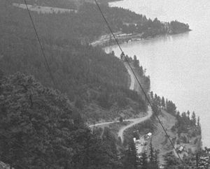 Survey and construction of the Pacific Great Eastern Railway along the lakes, completed by 1915, promulgated Shalalth as the "port" for the Bridge River
goldfields beyond the pass, and a variety of cartage services and hostelries sprung up at the base of the road, just around the point from The Mission and the core village-area of Shalalth.
 The traffic of professionals visiting the mines included Geoffrey Downton, a hydroelectric engineer who was the first to notice the hydroelectric potential resulting from the 1600' difference in elevation between the Bridge River
and Seton Lake
, which are only narrowly separated by Mission Ridge.
 Development of the electrical potential was in full swing by the mid-1920s, with a "model village" erected around the west side of the bay where Shalalth is located, and one of the tunnels piercing the mountainside above completed, but construction came to a halt with the onset of the Great Depression
and the collapse of the finances backing the project, and work ground to a halt in 1929. The townsite remained largely empty during the 1930s, although steady traffic to the mines in the Bridge River Country over the mountain kept the hotels busy.
came, the semi-abandoned village built for the hydro project at the rail stop of South Shalalth, which had gone dormant at the start of the Great Depression
and colloquially known as Bridge River
, was chosen for one of several relocation centres for Japanese-Canadians from the coast in the Lillooet
area. One of the relocatees at Shalalth was Dr. Masajiro Miyazaki
, a US-trained osteopath who stayed on after the war and became one of Lillooet's two Companions of the Order of Canada
.
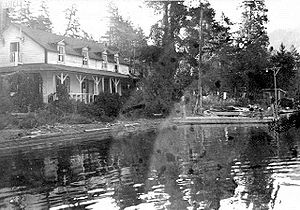
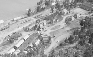 After the war, construction of the hydroelectric project resumed with a vengeance, and along with a new boom in traffic to the mines came a surge in equipment to finish the power project. For the next twenty or twenty-five years, Shalalth became the main transportation hub for the surrounding region, with near-24 hour heavy traffic over the pass, either to and from the mines or to the new, expanded damsite just over the pass at the head of the Bridge River Canyon. In addition to lakeside hostelries such as Seton House and Shalalth Lodge at Shalalth itself, a large hotel was built above the hydro townsite's railway station, adjacent to the managers' houses and the semicircle of barracks built for workmen (which had been used for the Japanese relocation, as had the empty houses in the townsite itself). The hotel's guests included not only project-related visitors but businessmen and investors en route over Mission Mountain to visit the Bridge River
mines. The hotel sadly burned down around 1949.
During the 1950s, the population of the Bridge River Townsite on Seton Lake
and Seton Portage area mushroomed into the thousands, mostly single men as is typical of construction booms but with enough families to boost the schools population into the hundreds. Other hydro townsites were located at Terzaghi Dam in the Bridge River Canyon, at Lajoie, below the site of Lajoie Dam 35 miles upriver, and also caused a building boom in Lillooet, filling in the formerly empty land between the old Main Street and the train station.
gold towns, at the far upper end of that valley, prompted community efforts to build a road via the Bridge River Canyon
directly to Lillooet
, which after the hydro project was finished had the effect of reducing the importance of the Mission Mountain Road and therefore also of Shalalth, once the hydro project
was completed in 1962.
built a new residential subdivision named Ohin, further east than the traditional Shalalth rancherie area (beginning at the base of the Mission Mountain Road to a few coves east). The name Ohin, pronounced OO(kh)win means "frostbite", is a reminder of the bitter cold of the Seton valley in winter. Beyond Ohin the roads peter out towards Lillooet, and travel to the foot of the lake is possible only by rail or water (although fragments of the old cliffside catwalks of the Lillooet Cattle Trail
remain in places). There is a private recreational property before the first point, and two isolated reserves on debris fans farther along the lake, all of which are only accessible by water or rail.
 Because of the obstacle posed by the lakeshore, the Mission Mountain Road remains the valley's only official road contact with the outside world, although the High Line Road to D'Arcy
/N'quatqua
is serviceable for most vehicles (but not recognized as an official roadway for insurance purposes). Water taxi service is available on Seton Lake, but has no formal schedule or licensed service. Most pleasure craft on the lake are from the Lillooet end.
culture and the St'at'imcets language
.
, which is the region's main social and commercial centre. The rail line is now transited by a blue-plate tourism service, the Rocky Mountaineer
, but fares are prohibitive and the service only stops locally in Lillooet. Shalalth remains without easy road access to the outside world, the only two routes in and out of the valley being extremely difficult mountain roads - the Mission Mountain Road, and a powerline road along Anderson Lake known as the High-Line Road, leading to the native and recreational community of D'Arcy (N'quatqua
) at the farther end of that lake, which connects by regular road to Highway 99 at Mount Currie
, and from there to Pemberton
, Whistler
, Squamish
and Vancouver.
Seton Lake
Seton Lake is a freshwater fjord draining east via the Seton River into the Fraser River at the town of Lillooet, British Columbia, about 22 km long and 243 m in elevation and 26.2 square kilometres in area...
Band of the St'at'imc (Lillooet) Nation
St'at'imc
The St'át'imc are an Interior Salish people located in the southern Coast Mountains and Fraser Canyon region of the Interior of the Canadian province of British Columbia.St'át'imc culture displayed many features typical of Northwest Coast peoples: the...
and location of the two main powerhouses of the Bridge River Power Project
Bridge River Power Project
The Bridge River Power Project is a hydroelectric power development in the Canadian province of British Columbia, located in the Lillooet Country between Whistler and Lillooet...
.
The word Shalalth ' onMouseout='HidePop("27984")' href="/topics/St'at'imcets_language">St'at'imcets
St'at'imcets language
Lillooet or Lilloet, also known as St’át’imcets , is the Interior Salishan language of the St’át’imc, spoken in southern British Columbia, Canada around the middle Fraser and Lillooet rivers. The dialect of the Lower Lillooet people uses the name Ucwalmícwts as St’át’imcets properly means "the...
, the Lillooet language) means simply "lake" or, particularly, the lake, meaning Seton Lake
Seton Lake
Seton Lake is a freshwater fjord draining east via the Seton River into the Fraser River at the town of Lillooet, British Columbia, about 22 km long and 243 m in elevation and 26.2 square kilometres in area...
, a freshwater fjord
Fjord
Geologically, a fjord is a long, narrow inlet with steep sides or cliffs, created in a valley carved by glacial activity.-Formation:A fjord is formed when a glacier cuts a U-shaped valley by abrasion of the surrounding bedrock. Glacial melting is accompanied by rebound of Earth's crust as the ice...
stretching twenty miles through a desert canyon westwards from the Fraser River
Fraser River
The Fraser River is the longest river within British Columbia, Canada, rising at Fraser Pass near Mount Robson in the Rocky Mountains and flowing for , into the Strait of Georgia at the city of Vancouver. It is the tenth longest river in Canada...
at Lillooet
Lillooet, British Columbia
Lillooet is a community on the Fraser River in western Canada, about up the British Columbia Railway line from Vancouver. Situated at an intersection of deep gorges in the lee of the Coast Mountains, it has a dry climate- of precipitation is recorded annually at the town's weather station,...
.
Geography
At the western end of that lake is a short isthmus of land, beyond which is the similar-sized Anderson Lake and the start of pavement southwestwards through the resort areas of PembertonPemberton, British Columbia
Pemberton is a village north of Whistler in the Pemberton Valley of British Columbia in Canada, with a population of 2,192. Until the 1960s the village could be accessed only by train but that changed when Highway 99 was built through Whistler and Pemberton.-Climate:The climate of Pemberton is...
and Whistler
Whistler, British Columbia
Whistler is a Canadian resort town in the southern Pacific Ranges of the Coast Mountains in the province of British Columbia, Canada, approximately north of Vancouver...
via the port, railway and logging town of Squamish
Squamish, British Columbia
Squamish is a community and a district municipality in the Canadian province of British Columbia, located at the north end of Howe Sound on the Sea to Sky Highway...
to Vancouver. Located on the portage is the neighbouring community of Seton Portage
Seton Portage, British Columbia
Seton Portage is a historic rural community in British Columbia, Canada, that is about 25 km west of Lillooet, located between Seton Lake and Anderson Lake. "The Portage" was formed about 10,000 years ago when the flank of the Cayoosh Range, which is the south flank of the valley, let go and...
, which contains the other main communities of the Seton Lake Band
Seton Lake First Nation
The Seton Lake First Nation, aka the Seton Lake Indian Band, is a First Nations government located in the Central Interior-Fraser Canyon region of the Canadian province of British Columbia. It is a member of the Lillooet Tribal Council, which is the largest grouping of band governments of the...
of the St'at'imc Nation
St'at'imc
The St'át'imc are an Interior Salish people located in the southern Coast Mountains and Fraser Canyon region of the Interior of the Canadian province of British Columbia.St'át'imc culture displayed many features typical of Northwest Coast peoples: the...
plus a mix of residential and resort homes owned by non-natives (pop. 700).
19th-century history
These lakes figured prominently as part of the Douglas RoadDouglas Road
The Douglas Road, aka the Lillooet Trail, Harrison Trail or Lakes Route, was a goldrush-era transportation route from the British Columbia Coast to the Interior...
or "Lakes Route", a series of trails and portages from the head of river navigation from the Coast at Port Douglas
Port Douglas, British Columbia
Port Douglas, sometimes referred to simply as Douglas, is a remote community in British Columbia, Canada at the head of Harrison Lake, which is the head of river navigation from the Strait of Georgia...
on Harrison Lake
Harrison Lake
Harrison Lake is the largest lake in the southern Coast Mountains of Canada, being about 250 square kilometres in area. It is about 60 km in length and at its widest almost 9 km across. Its southern end, at the resort community of Harrison Hot Springs, is c. 95 km east of...
. During the Fraser Canyon Gold Rush
Fraser Canyon Gold Rush
The Fraser Canyon Gold Rush, began in 1858 after gold was discovered on the Thompson River in British Columbia at its confluence with the Nicoamen River. This was a few miles upstream from the Thompson's confluence with the Fraser River at present-day Lytton...
, a horde of miners bound for the upper Fraser bars around Lillooet
Lillooet, British Columbia
Lillooet is a community on the Fraser River in western Canada, about up the British Columbia Railway line from Vancouver. Situated at an intersection of deep gorges in the lee of the Coast Mountains, it has a dry climate- of precipitation is recorded annually at the town's weather station,...
streamed through the valley in the matter of a few weeks. Estimates range from 15,000-30,000 in this migration, although official records of the time suggest there were no more than 5,000 miners active on the upper Fraser at its peak.
During this migration, Shalalth was largely bypassed as the "road" at this point was the waters of Seton Lake
Seton Lake
Seton Lake is a freshwater fjord draining east via the Seton River into the Fraser River at the town of Lillooet, British Columbia, about 22 km long and 243 m in elevation and 26.2 square kilometres in area...
offshore from the benches above the lake forming the community. The Lakes Route was near-completely abandoned by the later 1860s due to the construction of the new Cariboo Wagon Road from Yale
Yale, British Columbia
Yale is an unincorporated town in the Canadian province of British Columbia. It was founded in 1848 by the Hudson's Bay Company as Fort Yale by Ovid Allard, the appointed manager of the new post, who named it after his superior, James Murray Yale, then Chief Factor of the Columbia District...
to the newer Cariboo Goldfields
Cariboo Gold Rush
The Cariboo Gold Rush was a gold rush in the Canadian province of British Columbia. Although the first gold discovery was made in 1859 at Horsefly Creek, followed by more strikes at Keithley Creek and Antler Horns lake in 1860, the actual rush did not begin until 1861, when these discoveries were...
farther north via the lower the Thompson River
Thompson River
The Thompson River is the largest tributary of the Fraser River, flowing through the south-central portion of British Columbia, Canada. The Thompson River has two main branches called the South Thompson and the North Thompson...
and the town Ashcroft, where that route branches off from that river via the Bonaparte River
Bonaparte River
The Bonaparte River is a tributary of the Thompson River, joining it at the community of Ashcroft, British Columbia. The river is about long, including the length of Bonaparte Lake...
.
By the late 19th century, an Oblate
Oblate (religion)
An oblate in Christian monasticism is a person who is specifically dedicated to God or to God's service. Currently, oblate has two meanings:...
mission had been established at Shalalth, which as a result became known as "the Mission", a term which gaves its name to creek coming down from the high mountain pass above, and to that pass and the ridge from there to Lillooet
Lillooet, British Columbia
Lillooet is a community on the Fraser River in western Canada, about up the British Columbia Railway line from Vancouver. Situated at an intersection of deep gorges in the lee of the Coast Mountains, it has a dry climate- of precipitation is recorded annually at the town's weather station,...
along the north side of Seton Lake
Seton Lake
Seton Lake is a freshwater fjord draining east via the Seton River into the Fraser River at the town of Lillooet, British Columbia, about 22 km long and 243 m in elevation and 26.2 square kilometres in area...
.
Bridge River
The Bridge River is, or was, a major tributary of British Columbia's Fraser River, entering that stream about six miles upstream from the town of Lillooet.-Name:Its name in the Lillooet language is Xwisten , sometimes spelled Nxwisten or Nxo-isten)...
Valley on the north side of the pass, and when that country's immense gold potential began to be increasingly prospected and exploited, the Mission Mountain trail evolved into the Mission Mountain Road, suitable for the first rugged trucks to replacement the old muletrains, although equipment for the mines being was still barged in by lake to Shalalth and then hauled piece-by-piece over the mountain. Then, before engines and freight wagons were brought in (a road along the route of the trail was not built until 1912) equipment and heavy supplies bound for the mines were rafted up the still-flowing Bridge River from a few miles west of the north foot of the pass (in order to avoid rapids and strong currents). Nearly all infrastructure costs for the development of the Mission Mountain Road and the Bridge River Road were born by local citizens, as the government would not invest; the same is true of the "New Road" through the canyon from Terzaghi Dam
Terzaghi Dam
Terzaghi Dam, located about 100 km NE of the resort of Whistler, British Columbia in western Canada, is the key diversion dam in the Bridge River Power Project. It forms the project's largest reservoir, Carpenter Lake west of Lillooet...
to Moha
Moha, British Columbia
Moha is a rural locality located at the confluence of the Bridge and Yalakom Rivers, 30 km northwest of Lillooet, British Columbia, Canada. The name derives from that of a rock formation on the north bank of the Yalakom River overlooking the confluence, meaning "land of plenty" and which...
.
20th-century history
Bridge River
The Bridge River is, or was, a major tributary of British Columbia's Fraser River, entering that stream about six miles upstream from the town of Lillooet.-Name:Its name in the Lillooet language is Xwisten , sometimes spelled Nxwisten or Nxo-isten)...
goldfields beyond the pass, and a variety of cartage services and hostelries sprung up at the base of the road, just around the point from The Mission and the core village-area of Shalalth.
Bridge River
The Bridge River is, or was, a major tributary of British Columbia's Fraser River, entering that stream about six miles upstream from the town of Lillooet.-Name:Its name in the Lillooet language is Xwisten , sometimes spelled Nxwisten or Nxo-isten)...
and Seton Lake
Seton Lake
Seton Lake is a freshwater fjord draining east via the Seton River into the Fraser River at the town of Lillooet, British Columbia, about 22 km long and 243 m in elevation and 26.2 square kilometres in area...
, which are only narrowly separated by Mission Ridge.
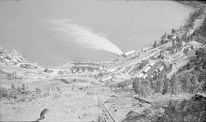
Bridge River Townsite (South Shalalth)
Great Depression
The Great Depression was a severe worldwide economic depression in the decade preceding World War II. The timing of the Great Depression varied across nations, but in most countries it started in about 1929 and lasted until the late 1930s or early 1940s...
and the collapse of the finances backing the project, and work ground to a halt in 1929. The townsite remained largely empty during the 1930s, although steady traffic to the mines in the Bridge River Country over the mountain kept the hotels busy.
Japanese internment
When World War IIWorld War II
World War II, or the Second World War , was a global conflict lasting from 1939 to 1945, involving most of the world's nations—including all of the great powers—eventually forming two opposing military alliances: the Allies and the Axis...
came, the semi-abandoned village built for the hydro project at the rail stop of South Shalalth, which had gone dormant at the start of the Great Depression
Great Depression
The Great Depression was a severe worldwide economic depression in the decade preceding World War II. The timing of the Great Depression varied across nations, but in most countries it started in about 1929 and lasted until the late 1930s or early 1940s...
and colloquially known as Bridge River
Bridge River
The Bridge River is, or was, a major tributary of British Columbia's Fraser River, entering that stream about six miles upstream from the town of Lillooet.-Name:Its name in the Lillooet language is Xwisten , sometimes spelled Nxwisten or Nxo-isten)...
, was chosen for one of several relocation centres for Japanese-Canadians from the coast in the Lillooet
Lillooet, British Columbia
Lillooet is a community on the Fraser River in western Canada, about up the British Columbia Railway line from Vancouver. Situated at an intersection of deep gorges in the lee of the Coast Mountains, it has a dry climate- of precipitation is recorded annually at the town's weather station,...
area. One of the relocatees at Shalalth was Dr. Masajiro Miyazaki
Masajiro Miyazaki
Dr. Masajiro Miyazaki D.O., CM was a Japanese-Canadian osteopath who practised in Vancouver prior to World War II. During World War II, he was appointed as a coroner by the British Columbia Provincial Police in the town of Lillooet, British Columbia...
, a US-trained osteopath who stayed on after the war and became one of Lillooet's two Companions of the Order of Canada
Order of Canada
The Order of Canada is a Canadian national order, admission into which is, within the system of orders, decorations, and medals of Canada, the second highest honour for merit...
.
Post-War Bridge River townsite
Bridge River
The Bridge River is, or was, a major tributary of British Columbia's Fraser River, entering that stream about six miles upstream from the town of Lillooet.-Name:Its name in the Lillooet language is Xwisten , sometimes spelled Nxwisten or Nxo-isten)...
mines. The hotel sadly burned down around 1949.
During the 1950s, the population of the Bridge River Townsite on Seton Lake
Seton Lake
Seton Lake is a freshwater fjord draining east via the Seton River into the Fraser River at the town of Lillooet, British Columbia, about 22 km long and 243 m in elevation and 26.2 square kilometres in area...
and Seton Portage area mushroomed into the thousands, mostly single men as is typical of construction booms but with enough families to boost the schools population into the hundreds. Other hydro townsites were located at Terzaghi Dam in the Bridge River Canyon, at Lajoie, below the site of Lajoie Dam 35 miles upriver, and also caused a building boom in Lillooet, filling in the formerly empty land between the old Main Street and the train station.
Building of the Mission Mountain Road
A medical crisis in Bralorne, the most important of the Bridge RiverBridge River
The Bridge River is, or was, a major tributary of British Columbia's Fraser River, entering that stream about six miles upstream from the town of Lillooet.-Name:Its name in the Lillooet language is Xwisten , sometimes spelled Nxwisten or Nxo-isten)...
gold towns, at the far upper end of that valley, prompted community efforts to build a road via the Bridge River Canyon
Bridge River
The Bridge River is, or was, a major tributary of British Columbia's Fraser River, entering that stream about six miles upstream from the town of Lillooet.-Name:Its name in the Lillooet language is Xwisten , sometimes spelled Nxwisten or Nxo-isten)...
directly to Lillooet
Lillooet, British Columbia
Lillooet is a community on the Fraser River in western Canada, about up the British Columbia Railway line from Vancouver. Situated at an intersection of deep gorges in the lee of the Coast Mountains, it has a dry climate- of precipitation is recorded annually at the town's weather station,...
, which after the hydro project was finished had the effect of reducing the importance of the Mission Mountain Road and therefore also of Shalalth, once the hydro project
Bridge River Power Project
The Bridge River Power Project is a hydroelectric power development in the Canadian province of British Columbia, located in the Lillooet Country between Whistler and Lillooet...
was completed in 1962.
Ohin
In recent history, the Seton Lake Indian BandSeton Lake First Nation
The Seton Lake First Nation, aka the Seton Lake Indian Band, is a First Nations government located in the Central Interior-Fraser Canyon region of the Canadian province of British Columbia. It is a member of the Lillooet Tribal Council, which is the largest grouping of band governments of the...
built a new residential subdivision named Ohin, further east than the traditional Shalalth rancherie area (beginning at the base of the Mission Mountain Road to a few coves east). The name Ohin, pronounced OO(kh)win means "frostbite", is a reminder of the bitter cold of the Seton valley in winter. Beyond Ohin the roads peter out towards Lillooet, and travel to the foot of the lake is possible only by rail or water (although fragments of the old cliffside catwalks of the Lillooet Cattle Trail
Lillooet Cattle Trail
The Lillooet Cattle Trail, also known as the Lillooet-Burrard Cattle Trail and also as the Lillooet Trail , was an unusual and daring public works undertaking by the Province of British Columbia in the 1877, and was the largest 19th Century public works expenditure at $35,000 of the new province...
remain in places). There is a private recreational property before the first point, and two isolated reserves on debris fans farther along the lake, all of which are only accessible by water or rail.
Along the lake to Lillooet
The distance from the end of roads in Shalalth and Ohin to roads out of Lillooet is only about 10 miles along the lake, but the cliffside of the lake is too severe to allow any road construction because of the railway - which is already built on trestles. Locals sometimes walk the line, to the disapproval of the railway company. Sections of the old Lillooet Trail catwalks still exist on the cliffs above the rail line but are not safe to use. Mountain goats and sheep remain common on the slopes of Mission Ridge above Shalalth, and particularly along the bluffs around Retaskit and at Seton Beach, at the Lillooet end of the lake.D'Arcy, British Columbia
D'Arcy is an unincorporated community in the Canadian province of British Columbia, approximately 150 kilometres northeast of the city of Vancouver...
/N'quatqua
N'quatqua
N'Quatqua, variously spelled Nequatque, N'quat'qua, is the proper historic name in the St'at'imcets language for the First Nations village of the Stl'atl'imx people of the community of D'Arcy, which is at the upper end of Anderson Lake about 35 miles southeast of Lillooet and about the same...
is serviceable for most vehicles (but not recognized as an official roadway for insurance purposes). Water taxi service is available on Seton Lake, but has no formal schedule or licensed service. Most pleasure craft on the lake are from the Lillooet end.
Social conditions
In the years since, the valley has dwindled into quietude, with the native people once again the majority of the population in the valley, and especially at Shalalth itself. Their local economy is based on a small native-run timber milling outfit and various small businesses, and there is a native-run school dedicated to the preservation and encouragement of St'at'imcSt'at'imc
The St'át'imc are an Interior Salish people located in the southern Coast Mountains and Fraser Canyon region of the Interior of the Canadian province of British Columbia.St'át'imc culture displayed many features typical of Northwest Coast peoples: the...
culture and the St'at'imcets language
St'at'imcets language
Lillooet or Lilloet, also known as St’át’imcets , is the Interior Salishan language of the St’át’imc, spoken in southern British Columbia, Canada around the middle Fraser and Lillooet rivers. The dialect of the Lower Lillooet people uses the name Ucwalmícwts as St’át’imcets properly means "the...
.
Transportation
Regular passenger service to and from neighbouring native communities to the southwest and North Vancouver beyond ended in recent years, but a rail shuttle still operates along the tracks to LillooetLillooet, British Columbia
Lillooet is a community on the Fraser River in western Canada, about up the British Columbia Railway line from Vancouver. Situated at an intersection of deep gorges in the lee of the Coast Mountains, it has a dry climate- of precipitation is recorded annually at the town's weather station,...
, which is the region's main social and commercial centre. The rail line is now transited by a blue-plate tourism service, the Rocky Mountaineer
Rocky Mountaineer
Rocky Mountaineer is a Canadian tour company offering Western Canadian vacation packages that operates trains on four rail routes through British Columbia and Alberta.-Background:...
, but fares are prohibitive and the service only stops locally in Lillooet. Shalalth remains without easy road access to the outside world, the only two routes in and out of the valley being extremely difficult mountain roads - the Mission Mountain Road, and a powerline road along Anderson Lake known as the High-Line Road, leading to the native and recreational community of D'Arcy (N'quatqua
N'quatqua
N'Quatqua, variously spelled Nequatque, N'quat'qua, is the proper historic name in the St'at'imcets language for the First Nations village of the Stl'atl'imx people of the community of D'Arcy, which is at the upper end of Anderson Lake about 35 miles southeast of Lillooet and about the same...
) at the farther end of that lake, which connects by regular road to Highway 99 at Mount Currie
Mount Currie, British Columbia
Mount Currie is a small community in British Columbia, 164 kilometres north-west of Vancouver and 40 kilometres north-west of Whistler along Highway 99....
, and from there to Pemberton
Pemberton, British Columbia
Pemberton is a village north of Whistler in the Pemberton Valley of British Columbia in Canada, with a population of 2,192. Until the 1960s the village could be accessed only by train but that changed when Highway 99 was built through Whistler and Pemberton.-Climate:The climate of Pemberton is...
, Whistler
Whistler, British Columbia
Whistler is a Canadian resort town in the southern Pacific Ranges of the Coast Mountains in the province of British Columbia, Canada, approximately north of Vancouver...
, Squamish
Squamish, British Columbia
Squamish is a community and a district municipality in the Canadian province of British Columbia, located at the north end of Howe Sound on the Sea to Sky Highway...
and Vancouver.
Climate
See also
- Seton Lake First NationSeton Lake First NationThe Seton Lake First Nation, aka the Seton Lake Indian Band, is a First Nations government located in the Central Interior-Fraser Canyon region of the Canadian province of British Columbia. It is a member of the Lillooet Tribal Council, which is the largest grouping of band governments of the...
- Seton Portage, British ColumbiaSeton Portage, British ColumbiaSeton Portage is a historic rural community in British Columbia, Canada, that is about 25 km west of Lillooet, located between Seton Lake and Anderson Lake. "The Portage" was formed about 10,000 years ago when the flank of the Cayoosh Range, which is the south flank of the valley, let go and...
- Bridge River Power ProjectBridge River Power ProjectThe Bridge River Power Project is a hydroelectric power development in the Canadian province of British Columbia, located in the Lillooet Country between Whistler and Lillooet...
External links
- Bridge River-Lillooet Country Archive
- http://www3.vpl.vancouver.bc.ca/dbtw-wpd/exec/dbtwpub.dll?AC=GET_RECORD&XC=/dbtw-wpd/exec/dbtwpub.dll&BU=http%3A%2F%2Fwww3.vpl.vancouver.bc.ca%2Fspe%2Fhistphotos%2F&TN=PHOTOS&SN=AUTO28584&SE=682&RN=0&MR=5&TR=2000&TX=1000&ES=0&CS=0&XP=&RF=briefweb&EF=&DF=Full+Photo&RL=0&EL=0&DL=0&NP=2&ID=&MF=&MQ=&TI=0&DT=&ST=0&IR=16520&NR=0&NB=0&SV=0&BG=&FG=&QS=&OEX=ISO-8859-1&OEH=ISO-8859-1Shalalth c.1950, Vancouver Public Library photo no. 33720]