
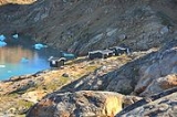
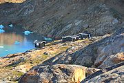
Sermilik Station
Encyclopedia
Glaciology
Glaciology Glaciology Glaciology (from Middle French dialect (Franco-Provençal): glace, "ice"; or Latin: glacies, "frost, ice"; and Greek: λόγος, logos, "speech" lit...
research station
Research station
A research station is a station built for the purpose of conducting scientific research. Research station sites might include outer space and oceans. Many nations have research stations in Antarctica; Showa Station, Halley and Troll are examples...
on Ammassalik Island, dedicated to the research of the nearby the Mittivakkat Glacier
Mittivakkat Glacier
The Mittivakkat Glacier is located in SE Greenland, part of the largest icefield on Ammassalik Island. This glacier has been in retreat throughout most of recorded history ....
. The station is located approximately at 65°41′N 37°55′W on the west side of the Ammasalik island in south east Greenland, on the shore of the Sermilik Fjord. The station is not permanently staffed. However, during most times in summer they will have researchers working there.
History
The station was built in 1970 to provide the logistical base for the research. In 1972, the main building was destroyed by an avalanche. It was rebuilt later closer to the shore, which is its current location.Transportation
The station is located on the west side of Ammassalik Island. The closest settlement is TasiilaqTasiilaq
Tasiilaq is a town in the Sermersooq municipality in southeastern Greenland. With 1,930 inhabitants as of 2010, it is the most populous community on the eastern coast, and the seventh-largest town in Greenland...
, and it would take around 1 day on foot to get from there to the station. The station is situated on a popular hiking route around the island.
See also
- Dye 3Dye 3Dye 3 is an ice core site and previously part of the Distant Early Warning line, located at in Greenland. As a DEW line base, it was disbanded in years 1990/1991....
- EismitteEismitteEismitte, in English also called Mid-Ice, was the site of an Arctic expedition in the interior of Greenland that took place from July 1930 through August 1931, and claimed the life of noted German scientist Alfred Wegener....
- Ice coreIce coreAn ice core is a core sample that is typically removed from an ice sheet, most commonly from the polar ice caps of Antarctica, Greenland or from high mountain glaciers elsewhere. As the ice forms from the incremental build up of annual layers of snow, lower layers are older than upper, and an ice...
- Liverpool LandLiverpool LandLiverpool Land is a peninsula in eastern Greenland.- Geography :The peninsula is bounded by Scoresby Sund in the south, Carlsberg Fjord in the northwest, Kangerterajiva in the southwest, the Greenland Sea in the east, and Jameson Land in the west...
- Milne LandMilne LandMilne Land is a large island in eastern Greenland. It is the third largest island of Greenland, after the main island of Greenland and Disko Island. It is named after British admiral David Milne. It is 113 km long from Moræne Pynt in the southwest to Bregnepynt in the northeast, and up to 45 km...
- NEEM CampNEEM CampNEEM Camp is a small research facility on the northern Greenland Ice Sheet, used as a base for ice core drilling. It is located about 313 km east of the closest coast, Peabody Bay in northern Greenland, 275 km northwest of the historical ice sheet camp North Ice, and 484 km ENE of...
- North IceNorth IceNorth Ice was the name of a research station of the British North Greenland Expedition on the inland ice of Greenland. The coordinates of the station were , with an altitude of 2,345 metres above sea level...
- Renland
- Scoresby SundScoresby SundScoresby Sund is an inlet system of the Greenland Sea on the eastern coast of Greenland. It has a tree-like structure, with a main body approximately long that branches into a system of fjords covering an area of about . The longest of these extends 340–350 km in from the coastline...
- Summit CampSummit CampSummit Camp, also Summit Station, is a year-round research station on the apex of the Greenland Ice Sheet. Its coordinates are variable, since the ice is moving. The coordinates provided here are as of July 2009. The station is located 3216 meters above sea level...