

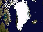
Dye 3
Encyclopedia
Dye 3 is an ice core
site and previously part of the Distant Early Warning (DEW
) line, located at (65°11′N 43°49′W, 2480 masl) in Greenland
. As a DEW line base, it was disbanded in years 1990/1991.
An ice core
is a core sample
from the accumulation of snow and ice that has re-crystallized and trapped air bubbles over many years. The composition of these ice cores, especially the presence of hydrogen and oxygen isotopes, provides a picture of the climate at the time. Ice cores contain an abundance of climate information.
Inclusions in the snow, such as wind-blown dust, ash, bubbles of atmospheric gas and radioactive substances, remain in the ice. The variety of climatic proxies
is greater than in any other natural recorder of climate, such as tree rings or sediment layer
s. These include (proxies for) temperature
, ocean
volume, precipitation
, chemistry and gas composition of the lower atmosphere
, volcanic eruptions, solar variability, sea-surface productivity, desert extent and forest fires.
Typical ice cores are removed from an ice sheet such as the ice cap internal to Greenland
. Greenland is, by area, the world's largest island. The Greenland ice sheet
covers about 1.71 million km2 and contains about 2.6 million km3 of ice.
 The 'Greenland ice sheet' is a vast body of ice
covering 1.71 million km2, roughly 80% of the surface of Greenland
. It is the second largest ice body in the World
, after the Antarctic Ice Sheet
. The ice sheet
is almost 2,400 kilometers long in a north-south direction, and its greatest width is 1,100 kilometers at a latitude of 77°N
, near its northern margin. The mean altitude of the ice is 2,135 meters.
The ice in the current ice sheet is as old as 110,000 years. However,
it is generally thought that the Greenland Ice Sheet formed in the late Pliocene
or early Pleistocene
by coalescence of ice caps and glaciers. It did not develop at all until the late Pliocene, but apparently developed very rapidly with the first continental glaciation.
The ice surface reaches its greatest altitude on two north-south elongated domes, or ridges. The southern dome reaches almost 3,000 metres at latitudes 63°
–65°N
; the northern dome reaches about 3,290 metres at about latitude 72°N
. The crests of both domes are displaced east of the centre line of Greenland. The unconfined ice sheet does not reach the sea along a broad front anywhere in Greenland, so that no large ice shelves occur.
On the ice sheet, temperatures are generally substantially lower than elsewhere in Greenland. The lowest mean annual temperatures, about -31°C (-24°F), occur on the north-central part of the north dome, and temperatures at the crest of the south dome are about -20°C (-4°F).
During winter, the ice sheet takes on a strikingly clear blue/green color. During summer, the top layer of ice melts leaving pockets of air in the ice that makes it look white. Positioned in the Arctic
, the Greenland ice sheet is especially vulnerable to global warming
. Arctic climate is now rapidly warming.
) Line radar stations built by the United States of America (US) between 1955 and 1960 across Alaska, Canada, Greenland and Iceland at a cost of billions of dollars.
After extensive studies in late 1957, the US Air Force (USAF) selected sites for two radar stations on the ice cap in southern Greenland. Dye 2 (66°29'30"N 46°18'19"W, 2338 masl) was built approximately 100 miles east of Sondrestrom AB and 90 miles south of the Arctic Circle at an altitude of 7,600 feet. Dye 3 was located approximately 100 miles east of Dye 2 and slightly south at an elevation of 8,600 feet, contrary to USAF map above.
The new radar sites were found to receive from three to four feet of snow each year. The snow was formed into large drifts by winds constantly blowing as much as 100 mph. To overcome this, the Dye sites were elevated approximately 20 feet above the ice cap surface. Dye 3 was completed in 1960.
Dye 3 was disbanded in the years 1990/1991 as a DEW line base.
s in Greenland
. GISP involved scientists and funding agencies from Denmark, Switzerland and the United States. Besides the U.S. National Science Foundation, funding was provided by the Swiss National Science Foundation and the Danish Commission for Scientific Research in Greenland. The ice cores provide a proxy archive of temperature and atmospheric constituents that help to understand past climate variations.
Annual field expeditions were carried out to drill intermediate depth cores at various locations on the ice sheet
:
“On most of the Greenland ice sheet, however, the annual accumulation rate is considerably higher than 0.2 m ice a-1, and the delta method therefore works thousands of years backwards in time, the only limitation being obliteration of the annual delta cycles by diffusion of the water molecule in the solid ice....” Delta refers to the changing proportion of oxygen-18 in the different seasonal layers. “The main reason for the seasonal delta variations is that, on its travel to the polar regions, a precipitating air mass is generally cooled more in winter than in summer.” “... the annual layer thickness...decreases from 19 cm in 2,000-yr-old ice to 2 cm in 10,000-yr-old ice due to plastic thinning of the annual layers as they sink towards greater depths10.” “... volcanic acids in snow layers deposited shortly after a large volcanic eruption can be detected - as elevated specific conductivities measured on melted ice samples8, or as elevated acidities revealed by an electric current through the solid ice...”
Measurements of [SO42-] and [NO3-] in firn
samples spanning the period 1895-1978 were taken from the Dye 3 1978 core down to 70 m.
After working out various logistical
and engineering
problems related to the development of a more sophisticated drilling rig
, drilling to bedrock
at Dye 3 began in the summer of 1979 using a new Danish electro-mechanical ice drill yielding a 10.2 cm diameter core. From July to August 1979 using ISTUK, 273 m of core was removed. At the end of the 1980 field season ISTUK had gnawed down to 901 m. In 1981 at a depth of 1785 m dust and conductivity measurements indicated the beginning of ice from the last glaciation. Coring continued and on August 10, 1981, bedrock was reached at a depth of 2038 m. The depth range for the Danish drill was 80–2038 m.
The Dye 3 site was a compromise: glaciologically
, a higher site on the ice divide
with smooth bedrock would have been better; logistically, such a site would have been too remote.
The borehole is 41.5 km east of the local ice divide of the south Greenland ice sheet.
The depth interval 800 to 1400 m would be a period approximately from about two thousand years ago to about five or six thousand years ago.
Melting has been commonplace throughout the Holocene. Summer melting is usually the rule at Dye 3, and there is occasional melting even in north Greenland. All of these meltings disturb the clarity of the annual record to some degree. “An exceptionally warm spell can produce features which extend downwards by percolation, along isolated channels, into the snow of several previous years. This can happen in regions which generally have little or no melting at the snow surface as exemplified during mid July 1954 in north-west Greenland4. Such an event could lead to the conclusion that two or three successive years had abnormally warm summers, whereas all the icing formed during a single period which lasted for several days. The location where melt features will have the greatest climactic significance is high in the percolation facies where summer melting is common but deep percolation is minimal4. Dye 3 in southern Greenland (65°11’N; 43°50’W) is such a location.”
The brittle zone mentioned above under "Core continuity" corresponds in Dye 3 1979 with the steady state grain size (crystal size) from ~637 - ~1737 m depth range. This is also the Holocene climatic optimum
period.
ice, and the lower portion is considered as deposited during the Wisconsin period.
From the δ18 O profile of the Dye 3 core it is relatively easy to differentiate the post-glacial climatic optimum
, portions thereof and earlier: the Pre-Boreal transition, the Allerød
, Bølling
, Younger Dryas
, and Oldest Dryas
. In the Dye 3 1979 oxygen isotope record, the Older Dryas
appears as a downward peak establishing a small, low-intensity gap between the Bølling and the Allerød.
During the transition from the Younger Dryas to the Pre-Boreal, the South Greenland temperature increased by 15°C in 50 years. At the beginning of this same transition the deuterium excess and dust concentration shifted to lower levels in less than 20 years.
The post-glacial climatic optimum
lasted from ~9000-4000 yrs B.P. as determined from Dye 3 1979 and Camp Century 1963 δ18 O profiles. Both Dye 3 1979 and Camp Century 1963 cores exhibit the 8.2 ka event
and the boundary event separating Holocene I from Holocene II.
cores revealed that high-altitude southern Greenland has been inhabited by a diverse array of conifer trees and insects within the past million years.
 To investigate the possibility of climatic cooling, scientists drilled into the Greenland ice caps to obtain core samples. The oxygen isotopes from the ice caps suggested that the Medieval Warm Period had caused a relatively milder climate in Greenland, lasting from roughly 800 to 1200. However from 1300 or so the climate began to cool. By 1420, we know that the "Little Ice Age
" had reached intense levels in Greenland.
For most of the arctic ice cores up to 1987, regions of the core with high dust concentrations correlate well with the ice having high deformation rates and small crystal diameters, in both Holocene and Wisconsin ice.
) due to the high accumulation rates.
From the delta-profile, the Renland ice cap in the Scoresbysund Fiord has always been separated from the inland ice, yet all the delta-leaps revealed in the Camp Century 1963 core recurred in the Renland ice core.
The Renland core is also the first to provide a continuous record of ammonium (NH4+) apparently through the whole glacial period.
The distribution of 10Be in the top 40 m of the Renland ice core has been reported and corroborates the 10Be cyclic fluctuation pattern from Dye 3.
to the bed of the Greenland Ice Sheet
at Summit, Central Greenland
from 1989 to 1992 at 72°35′N 37°38′W, 3238 masl.
and the Settlement layer) originating in Iceland have been identified in GRIP by comparison of chemical composition of glass shards from the ash. The other four have not been correlated with known ash deposits.
The Saksunarvatn tephra via radiocarbon dating
is ca 10,200 years BP.
an scientists produced a parallel core in the GRIP
project. GISP2 produced an ice core 3053.44 meters in depth, the deepest ice core recovered in the world at the time. The GRIP site was 30 km to the east of GISP2. "Down to a depth of 2790 m in GISP2 (corresponding to an age of about 110 kyr B.P.), the GISP2 and GRIP records are nearly identical in shape and in many of the details."
 The isotopic temperature records show 23 interstadial events correlateable between the GRIP and GISP2 records between 110 and 15 kyr B.P. Ice in both cores below 2790 m depth (records prior to 110 kyr B.P.) shows evidence of folding or tilting in structures too large to be fully observed in a single core.
The bulk of the GISP2 ice core is archived at the National Ice Core Laboratory
in Lakewood, Colorado
, United States.
(75.1 N, 42.32 W, 2917 m, ice thickness 3085). Drilling began in 1999 and was completed at bedrock
in on July 17, 2003. The NGRIP site was chosen to extract a long and undisturbed record stretching into the last glacial, and it was apparently successful.
Unusually, there is melting at the bottom of the NGRIP core - believed to be due to a high geothermal heat flux locally. This has the advantage that the bottom layers are less compressed by thinning than they would otherwise be: NGRIP annual layers at 105 kyr age are 1.1 cm thick, twice the GRIP thicknesses at equal age.
to avoid the flow distortions that render the bottom of the GRIP
and GISP
cores unreliable.
.
The size distribution of ice crystals changes with depth and approaches the Normal Grain Growth law via competing mechanisms of fragmentation (producing smaller polygonal grains) and grain boundary diffusion (producing larger, vertically compressed, horizontally expanded grains). Although some of the peaks for the deeper distributions appear to be slightly greater, the predicted steady state average grain size is 2.9±0.1 mm.
temperatures were. This is confirmed by sediment
cores, in particular MD95-2042 http://www.worldchanging.com/archives/001199.html.
"Several of the pieces look very much like blades of grass or pine needles," said University of Colorado at Boulder geological sciences Professor James White, an NGRIP principal investigator. "If confirmed, this will be the first organic material ever recovered from a deep ice-core drilling project," he said.
Ice core
An ice core is a core sample that is typically removed from an ice sheet, most commonly from the polar ice caps of Antarctica, Greenland or from high mountain glaciers elsewhere. As the ice forms from the incremental build up of annual layers of snow, lower layers are older than upper, and an ice...
site and previously part of the Distant Early Warning (DEW
Dew
[Image:Dew on a flower.jpg|right|220px|thumb|Some dew on an iris in Sequoia National Park]]Dew is water in the form of droplets that appears on thin, exposed objects in the morning or evening...
) line, located at (65°11′N 43°49′W, 2480 masl) in Greenland
Greenland
Greenland is an autonomous country within the Kingdom of Denmark, located between the Arctic and Atlantic Oceans, east of the Canadian Arctic Archipelago. Though physiographically a part of the continent of North America, Greenland has been politically and culturally associated with Europe for...
. As a DEW line base, it was disbanded in years 1990/1991.
An ice core
Ice core
An ice core is a core sample that is typically removed from an ice sheet, most commonly from the polar ice caps of Antarctica, Greenland or from high mountain glaciers elsewhere. As the ice forms from the incremental build up of annual layers of snow, lower layers are older than upper, and an ice...
is a core sample
Core sample
A core sample is a cylindrical section of a naturally occurring substance. Most core samples are obtained by drilling with special drills into the substance, for example sediment or rock, with a hollow steel tube called a core drill. The hole made for the core sample is called the "core hole". A...
from the accumulation of snow and ice that has re-crystallized and trapped air bubbles over many years. The composition of these ice cores, especially the presence of hydrogen and oxygen isotopes, provides a picture of the climate at the time. Ice cores contain an abundance of climate information.
Inclusions in the snow, such as wind-blown dust, ash, bubbles of atmospheric gas and radioactive substances, remain in the ice. The variety of climatic proxies
Proxy (climate)
In the study of past climates is known as paleoclimatology, climate proxies are preserved physical characteristics of the past that stand in for direct measurements , to enable scientists to reconstruct the climatic conditions that prevailed during much of the Earth's history...
is greater than in any other natural recorder of climate, such as tree rings or sediment layer
Varve
A varve is an annual layer of sediment or sedimentary rock.The word 'varve' is derived from the Swedish word varv whose meanings and connotations include 'revolution', 'in layers', and 'circle'. The term first appeared as Hvarfig lera on the first map produced by the Geological Survey of Sweden in...
s. These include (proxies for) temperature
Temperature
Temperature is a physical property of matter that quantitatively expresses the common notions of hot and cold. Objects of low temperature are cold, while various degrees of higher temperatures are referred to as warm or hot...
, ocean
Ocean
An ocean is a major body of saline water, and a principal component of the hydrosphere. Approximately 71% of the Earth's surface is covered by ocean, a continuous body of water that is customarily divided into several principal oceans and smaller seas.More than half of this area is over 3,000...
volume, precipitation
Precipitation (meteorology)
In meteorology, precipitation In meteorology, precipitation In meteorology, precipitation (also known as one of the classes of hydrometeors, which are atmospheric water phenomena is any product of the condensation of atmospheric water vapor that falls under gravity. The main forms of precipitation...
, chemistry and gas composition of the lower atmosphere
Atmosphere
An atmosphere is a layer of gases that may surround a material body of sufficient mass, and that is held in place by the gravity of the body. An atmosphere may be retained for a longer duration, if the gravity is high and the atmosphere's temperature is low...
, volcanic eruptions, solar variability, sea-surface productivity, desert extent and forest fires.
Typical ice cores are removed from an ice sheet such as the ice cap internal to Greenland
Greenland
Greenland is an autonomous country within the Kingdom of Denmark, located between the Arctic and Atlantic Oceans, east of the Canadian Arctic Archipelago. Though physiographically a part of the continent of North America, Greenland has been politically and culturally associated with Europe for...
. Greenland is, by area, the world's largest island. The Greenland ice sheet
Greenland ice sheet
The Greenland ice sheet is a vast body of ice covering , roughly 80% of the surface of Greenland. It is the second largest ice body in the world, after the Antarctic Ice Sheet. The ice sheet is almost long in a north-south direction, and its greatest width is at a latitude of 77°N, near its...
covers about 1.71 million km2 and contains about 2.6 million km3 of ice.
Greenland ice sheet
Ice
Ice is water frozen into the solid state. Usually ice is the phase known as ice Ih, which is the most abundant of the varying solid phases on the Earth's surface. It can appear transparent or opaque bluish-white color, depending on the presence of impurities or air inclusions...
covering 1.71 million km2, roughly 80% of the surface of Greenland
Greenland
Greenland is an autonomous country within the Kingdom of Denmark, located between the Arctic and Atlantic Oceans, east of the Canadian Arctic Archipelago. Though physiographically a part of the continent of North America, Greenland has been politically and culturally associated with Europe for...
. It is the second largest ice body in the World
World
World is a common name for the whole of human civilization, specifically human experience, history, or the human condition in general, worldwide, i.e. anywhere on Earth....
, after the Antarctic Ice Sheet
Antarctic ice sheet
The Antarctic ice sheet is one of the two polar ice caps of the Earth. It covers about 98% of the Antarctic continent and is the largest single mass of ice on Earth. It covers an area of almost 14 million square km and contains 30 million cubic km of ice...
. The ice sheet
Ice sheet
An ice sheet is a mass of glacier ice that covers surrounding terrain and is greater than 50,000 km² , thus also known as continental glacier...
is almost 2,400 kilometers long in a north-south direction, and its greatest width is 1,100 kilometers at a latitude of 77°N
77th parallel north
The 77th parallel north is a circle of latitude that is 77 degrees north of the Earth's equatorial plane, in the Arctic. It crosses the Atlantic Ocean, Europe, Asia, the Arctic Ocean and North America....
, near its northern margin. The mean altitude of the ice is 2,135 meters.
The ice in the current ice sheet is as old as 110,000 years. However,
it is generally thought that the Greenland Ice Sheet formed in the late Pliocene
Pliocene
The Pliocene Epoch is the period in the geologic timescale that extends from 5.332 million to 2.588 million years before present. It is the second and youngest epoch of the Neogene Period in the Cenozoic Era. The Pliocene follows the Miocene Epoch and is followed by the Pleistocene Epoch...
or early Pleistocene
Pleistocene
The Pleistocene is the epoch from 2,588,000 to 11,700 years BP that spans the world's recent period of repeated glaciations. The name pleistocene is derived from the Greek and ....
by coalescence of ice caps and glaciers. It did not develop at all until the late Pliocene, but apparently developed very rapidly with the first continental glaciation.
The ice surface reaches its greatest altitude on two north-south elongated domes, or ridges. The southern dome reaches almost 3,000 metres at latitudes 63°
63rd parallel north
The 63rd parallel north is a circle of latitude that is 63 degrees north of the Earth's equatorial plane. It crosses the Atlantic Ocean, Europe, Asia and North America....
–65°N
65th parallel north
The 65th parallel north is a circle of latitude that is 65 degrees north of the Earth's equatorial plane. It crosses the Atlantic Ocean, Europe, Asia and North America....
; the northern dome reaches about 3,290 metres at about latitude 72°N
72nd parallel north
The 72nd parallel north is a circle of latitude that is 72 degrees north of the Earth's equatorial plane, in the Arctic. It crosses the Atlantic Ocean, Europe, Asia, the Arctic Ocean and North America....
. The crests of both domes are displaced east of the centre line of Greenland. The unconfined ice sheet does not reach the sea along a broad front anywhere in Greenland, so that no large ice shelves occur.
On the ice sheet, temperatures are generally substantially lower than elsewhere in Greenland. The lowest mean annual temperatures, about -31°C (-24°F), occur on the north-central part of the north dome, and temperatures at the crest of the south dome are about -20°C (-4°F).
During winter, the ice sheet takes on a strikingly clear blue/green color. During summer, the top layer of ice melts leaving pockets of air in the ice that makes it look white. Positioned in the Arctic
Arctic
The Arctic is a region located at the northern-most part of the Earth. The Arctic consists of the Arctic Ocean and parts of Canada, Russia, Greenland, the United States, Norway, Sweden, Finland, and Iceland. The Arctic region consists of a vast, ice-covered ocean, surrounded by treeless permafrost...
, the Greenland ice sheet is especially vulnerable to global warming
Global warming
Global warming refers to the rising average temperature of Earth's atmosphere and oceans and its projected continuation. In the last 100 years, Earth's average surface temperature increased by about with about two thirds of the increase occurring over just the last three decades...
. Arctic climate is now rapidly warming.
Distance Early Warning Line
Dye-2 and 3 were among 58 Distance Early Warning (DEWDew
[Image:Dew on a flower.jpg|right|220px|thumb|Some dew on an iris in Sequoia National Park]]Dew is water in the form of droplets that appears on thin, exposed objects in the morning or evening...
) Line radar stations built by the United States of America (US) between 1955 and 1960 across Alaska, Canada, Greenland and Iceland at a cost of billions of dollars.
After extensive studies in late 1957, the US Air Force (USAF) selected sites for two radar stations on the ice cap in southern Greenland. Dye 2 (66°29'30"N 46°18'19"W, 2338 masl) was built approximately 100 miles east of Sondrestrom AB and 90 miles south of the Arctic Circle at an altitude of 7,600 feet. Dye 3 was located approximately 100 miles east of Dye 2 and slightly south at an elevation of 8,600 feet, contrary to USAF map above.
The new radar sites were found to receive from three to four feet of snow each year. The snow was formed into large drifts by winds constantly blowing as much as 100 mph. To overcome this, the Dye sites were elevated approximately 20 feet above the ice cap surface. Dye 3 was completed in 1960.
Dye 3 was disbanded in the years 1990/1991 as a DEW line base.
Greenland Ice Sheet Project (GISP)
The Greenland Ice Sheet Project (GISP) was a decade-long project to drill 20 ice coreIce core
An ice core is a core sample that is typically removed from an ice sheet, most commonly from the polar ice caps of Antarctica, Greenland or from high mountain glaciers elsewhere. As the ice forms from the incremental build up of annual layers of snow, lower layers are older than upper, and an ice...
s in Greenland
Greenland
Greenland is an autonomous country within the Kingdom of Denmark, located between the Arctic and Atlantic Oceans, east of the Canadian Arctic Archipelago. Though physiographically a part of the continent of North America, Greenland has been politically and culturally associated with Europe for...
. GISP involved scientists and funding agencies from Denmark, Switzerland and the United States. Besides the U.S. National Science Foundation, funding was provided by the Swiss National Science Foundation and the Danish Commission for Scientific Research in Greenland. The ice cores provide a proxy archive of temperature and atmospheric constituents that help to understand past climate variations.
Annual field expeditions were carried out to drill intermediate depth cores at various locations on the ice sheet
Ice sheet
An ice sheet is a mass of glacier ice that covers surrounding terrain and is greater than 50,000 km² , thus also known as continental glacier...
:
- Dye 3 in 1971 to 372 m
- North Site (75°46’N 42°27’W, 2870 masl) in 1972 to 15 m
- North Central (74°37’N 39°36’W) in 1972 to 100 m
- Crête (71°7’N 37°19’W) in 1972 to 15 m
- Milcent (70°18’N 45°35’W, 2410 masl) in 1973 to 398 m
- Dye 2 (66°23’N 46°11’W) in 1973 to 50 m
- Dye 3 in 1973, an intermediate drilling to c. 390 m
- Crête in 1974 to 404.64 m
- Dye 2 in 1974 to 101 m
- SummitSummitSummit may refer to:*Summit , the highest point of a mountain, hill, road, or railway.-Locations:United States* Summit, Arizona* Summit, Arkansas* Summit, California** Summit, Butte County, California** Summit, Kern County, California...
(71°17’N 37°56’W, 3212 masl) in 1974 to 31 m - Dye 3 in 1975 to 95 m
- South Dome (63°33’N 44°36’W, 2850 masl) in 1975 to 80 m
- Hans Tausen (82°30’N 38°20’W, 1270 masl) in 1975 to 60 m
- Dye 3 in 1976 to 93 m
- Hans Tausen in 1976 to 50 m
- Hans Tausen in 1977 to 325 m
- Camp Century (77°10’N 61°8’W, 1885 masl) in 1977 to 49 m
- Dye 2 in 1977 to 84 m
- Camp III (69°43’N 50°8’W) in 1977 to 84 m
- Dye 3 1978 to 90 m
- Camp III in 1978 to 80 m.
“On most of the Greenland ice sheet, however, the annual accumulation rate is considerably higher than 0.2 m ice a-1, and the delta method therefore works thousands of years backwards in time, the only limitation being obliteration of the annual delta cycles by diffusion of the water molecule in the solid ice....” Delta refers to the changing proportion of oxygen-18 in the different seasonal layers. “The main reason for the seasonal delta variations is that, on its travel to the polar regions, a precipitating air mass is generally cooled more in winter than in summer.” “... the annual layer thickness...decreases from 19 cm in 2,000-yr-old ice to 2 cm in 10,000-yr-old ice due to plastic thinning of the annual layers as they sink towards greater depths10.” “... volcanic acids in snow layers deposited shortly after a large volcanic eruption can be detected - as elevated specific conductivities measured on melted ice samples8, or as elevated acidities revealed by an electric current through the solid ice...”
Dye 3 cores
Although available GISP data gathered over the earlier seven years, pointed to north-central Greenland as the optimum site location for the first deep drilling, financial restrictions forced the selection of the logistically convenient Dye-3 location.Dye 3 1971
Preliminary GISP field work started in 1971 at Dye 3 (65°11′N 43°49′W), where a 372 meter deep, 10.2 cm diameter core was recovered using a Thermal (US) drill type. Three more cores to depths of 90, 93, and 95 m were drilled with different drill types.Dye 3 1973
For an intermediate drilling c. 390 m, the drill was installed 25 m below the surface at the bottom of the Dye 3 radar station. Some 740 seasonal δ18 cycles were counted, indicating that the core reached back to 1231 AD. Evident in this coring was that as melt water seeps through the porous snow, it refreezes somewhere in the cold firn and disturbs the layer sequence.Dye 3 1975
A second core at Dye 3 was drilled in 1975 with a Shallow (Swiss) drill type to 95 m at 7.6 cm diameter.Dye 3 1976
A third core at Dye 3 was drilled in 1976 with a Wireline (US) drill type, 10.2 cm diameter, to 93 m.Dye 3 1978
Another core at Dye 3 was drilled in 1978 using a Shallow (US) drill type, 10.2 cm diameter, to 90 m.Measurements of [SO42-] and [NO3-] in firn
Firn
Firn is partially-compacted névé, a type of snow that has been left over from past seasons and has been recrystallized into a substance denser than névé. It is ice that is at an intermediate stage between snow and glacial ice...
samples spanning the period 1895-1978 were taken from the Dye 3 1978 core down to 70 m.
Dye 3 1979
In 1979, the initial Dye-3 deep bedrock drilling was started using a 22.2 cm diameter CRREL thermal (US) coring drill to produce an 18 cm diameter access hole, which was cased, to a depth of 77 m. The large diameter casing was inserted over the porous firn zone to contain the drilling fluid.After working out various logistical
Logistics
Logistics is the management of the flow of goods between the point of origin and the point of destination in order to meet the requirements of customers or corporations. Logistics involves the integration of information, transportation, inventory, warehousing, material handling, and packaging, and...
and engineering
Engineering
Engineering is the discipline, art, skill and profession of acquiring and applying scientific, mathematical, economic, social, and practical knowledge, in order to design and build structures, machines, devices, systems, materials and processes that safely realize improvements to the lives of...
problems related to the development of a more sophisticated drilling rig
Drilling rig
A drilling rig is a machine which creates holes or shafts in the ground. Drilling rigs can be massive structures housing equipment used to drill water wells, oil wells, or natural gas extraction wells, or they can be small enough to be moved manually by one person...
, drilling to bedrock
Bedrock
In stratigraphy, bedrock is the native consolidated rock underlying the surface of a terrestrial planet, usually the Earth. Above the bedrock is usually an area of broken and weathered unconsolidated rock in the basal subsoil...
at Dye 3 began in the summer of 1979 using a new Danish electro-mechanical ice drill yielding a 10.2 cm diameter core. From July to August 1979 using ISTUK, 273 m of core was removed. At the end of the 1980 field season ISTUK had gnawed down to 901 m. In 1981 at a depth of 1785 m dust and conductivity measurements indicated the beginning of ice from the last glaciation. Coring continued and on August 10, 1981, bedrock was reached at a depth of 2038 m. The depth range for the Danish drill was 80–2038 m.
The Dye 3 site was a compromise: glaciologically
Glaciology
Glaciology Glaciology Glaciology (from Middle French dialect (Franco-Provençal): glace, "ice"; or Latin: glacies, "frost, ice"; and Greek: λόγος, logos, "speech" lit...
, a higher site on the ice divide
Ice divide
An ice divide is the boundary on an ice sheet, ice cap or glacier separating opposing flow directions of ice, analogous to a water divide. Such ice divides are important for geochronology investigations using ice cores, because such coring is typically made on top of a dome of an ice sheet to avoid...
with smooth bedrock would have been better; logistically, such a site would have been too remote.
The borehole is 41.5 km east of the local ice divide of the south Greenland ice sheet.
Shear conditions
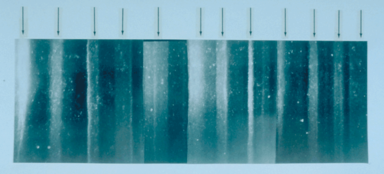
The Dye 3 cores were part of the GISP and, at 2037 meters, the final Dye 3 1979 core was the deepest of the 20 ice cores recovered from the Greenland ice sheet. The surface ice velocity is 12.5 ma−1, 61.2° true. At 500 m above bedrock, the ice velocity is ~10 ma−1, 61.2° true. The ice upstream and downstream from Dye 3 is flowing downhill (-) on ~0.48 % mean slope. The bedrock temperature is -13.22°C (as of 1984).Core continuity
The Dye 3 1979 core is not completely intact and is not undamaged. “Below 600 m, the ice became brittle with increasing depth and badly fractured between 800 and 1,200 m. The physical property of the core progressively improved and below ~1,400 m was of excellent quality.” “The deep ice core drilling terminated in August 1981. The ice core is 2035 m long and has a diameter of 10 cm. It was drilled with less than 6° deviation from vertical, and less than 2 m is missing. The deepest 22 m consists of silty ice with an increasing concentration of pebbles downward. In the depth interval 800 to 1400 m the ice was extremely brittle, and even careful handling unavoidably damaged this part of the core, but the rest of the core is in good to excellent condition.”The depth interval 800 to 1400 m would be a period approximately from about two thousand years ago to about five or six thousand years ago.
Melting has been commonplace throughout the Holocene. Summer melting is usually the rule at Dye 3, and there is occasional melting even in north Greenland. All of these meltings disturb the clarity of the annual record to some degree. “An exceptionally warm spell can produce features which extend downwards by percolation, along isolated channels, into the snow of several previous years. This can happen in regions which generally have little or no melting at the snow surface as exemplified during mid July 1954 in north-west Greenland4. Such an event could lead to the conclusion that two or three successive years had abnormally warm summers, whereas all the icing formed during a single period which lasted for several days. The location where melt features will have the greatest climactic significance is high in the percolation facies where summer melting is common but deep percolation is minimal4. Dye 3 in southern Greenland (65°11’N; 43°50’W) is such a location.”
Counting annual layers
As the drill site of Dye 3 receives more than twice as much accumulation as central Greenland, the annual layers are well resolved and relatively thick in the upper parts, making the core ideal for dating the most recent millennia. But, the high accumulation rate has resulted in relatively rapid ice flow (flow-induced layer thinning and diffusion of isotopes), Dye 3 1979 cannot be used for annual layer counting much more than 8 kyr back in time.Ice crystal diameter distribution
Crystal diameters range from ~0.2 cm at 1900 m from bedrock (depth 137 m) to ~0.42 cm vertical diameter (v) and ~0.55 cm horizontal diameter (h) at 300 m above bedrock (depth 1737 m). However, below 300 m crystal diameter decreases rapidly with increasing dust concentration to a minimum of ~0.05 cm at 200 m above bedrock (depth 1837 m), increasing again linearly to ~0.25 cm v and ~0.3 cm h just above bedrock. Crystal diameters remain approximately constant between 1400 to 300 m above bedrock (depths 637–1737 m), with the largest crystals and the largest distortion (~0.55 cm v and ~0.7 cm h) occurring at 1100 m above bedrock (depth 937 m).The brittle zone mentioned above under "Core continuity" corresponds in Dye 3 1979 with the steady state grain size (crystal size) from ~637 - ~1737 m depth range. This is also the Holocene climatic optimum
Holocene climatic optimum
The Holocene Climate Optimum was a warm period during roughly the interval 9,000 to 5,000 years B.P.. This event has also been known by many other names, including: Hypsithermal, Altithermal, Climatic Optimum, Holocene Optimum, Holocene Thermal Maximum, and Holocene Megathermal.This warm period...
period.
Beryllium 10 variations
As of 1998 the only long record available for 10Be is from Dye 3 1979. Questions were raised whether all parts of the Dye 3 1979 record reflect the sun activity or are affected by climatic and/or ice dynamics.Dust concentration
The dust concentration has a peak of ~3 mg/kg at 200 m above bedrock (depth 1837 m), second only to the silty ice (>20 mg/kg) of the bottom 25 m, which has a very high deformation rate.Ice ages
The uppermost 1780 m is considered HoloceneHolocene
The Holocene is a geological epoch which began at the end of the Pleistocene and continues to the present. The Holocene is part of the Quaternary period. Its name comes from the Greek words and , meaning "entirely recent"...
ice, and the lower portion is considered as deposited during the Wisconsin period.
From the δ18 O profile of the Dye 3 core it is relatively easy to differentiate the post-glacial climatic optimum
Holocene climatic optimum
The Holocene Climate Optimum was a warm period during roughly the interval 9,000 to 5,000 years B.P.. This event has also been known by many other names, including: Hypsithermal, Altithermal, Climatic Optimum, Holocene Optimum, Holocene Thermal Maximum, and Holocene Megathermal.This warm period...
, portions thereof and earlier: the Pre-Boreal transition, the Allerød
Allerød Oscillation
The Allerød period was a warm and moist global interstadial that occurred at the end of the last glacial period. The Allerød oscillation raised temperatures , before they declined again in the succeeding Younger Dryas period, which was followed by the present interglacial period.In some regions,...
, Bølling
Bølling Oscillation
The Bølling oscillation was a warm interstadial period between the Oldest Dryas and Older Dryas stadials, at the end of the last glacial period. It is named after a peat sequence discovered at Bølling lake, central Jutland...
, Younger Dryas
Younger Dryas
The Younger Dryas stadial, also referred to as the Big Freeze, was a geologically brief period of cold climatic conditions and drought between approximately 12.8 and 11.5 ka BP, or 12,800 and 11,500 years before present...
, and Oldest Dryas
Oldest Dryas
The Oldest Dryas was a climatic period, which occurred during the coldest stadial after the Weichselian glaciation in north Europe. In the Alps, the Oldest Dryas corresponds to the Gschnitz stadial of the Würm glaciation. The three “Dryas” periods are named for a marker species, Dryas octopetala,...
. In the Dye 3 1979 oxygen isotope record, the Older Dryas
Older Dryas
The Older Dryas was a stadial period between the Bølling and Allerød oscillations during the Pleistocene glacial period of ~11,700—12,000 uncalibrated years ago...
appears as a downward peak establishing a small, low-intensity gap between the Bølling and the Allerød.
During the transition from the Younger Dryas to the Pre-Boreal, the South Greenland temperature increased by 15°C in 50 years. At the beginning of this same transition the deuterium excess and dust concentration shifted to lower levels in less than 20 years.
The post-glacial climatic optimum
Holocene climatic optimum
The Holocene Climate Optimum was a warm period during roughly the interval 9,000 to 5,000 years B.P.. This event has also been known by many other names, including: Hypsithermal, Altithermal, Climatic Optimum, Holocene Optimum, Holocene Thermal Maximum, and Holocene Megathermal.This warm period...
lasted from ~9000-4000 yrs B.P. as determined from Dye 3 1979 and Camp Century 1963 δ18 O profiles. Both Dye 3 1979 and Camp Century 1963 cores exhibit the 8.2 ka event
8.2 kiloyear event
The 8.2 kiloyear event is the term that climatologists have adopted for a sudden decrease in global temperatures that occurred approximately 8,200 years before the present, or c. 6,200 BCE, and which lasted for the next two to four centuries...
and the boundary event separating Holocene I from Holocene II.
Fossils
Samples from the base of the 2 km deep Dye 3 1979 and the 3 km deep GRIPGrip
Grip may refer to:* Handle , a part of, or attachment to, an object, allowing it to be moved or used by hand* Grip strength, a measure of hand strength* Grippers, exercise machines used to increase hand strength- In sports :...
cores revealed that high-altitude southern Greenland has been inhabited by a diverse array of conifer trees and insects within the past million years.
Dye 3 1988
Ellen Mosley-Thompson led a 3-man glaciological team to drill an intermediate depth core at Dye 3, Greenland.Comparison with other Greenland ice cores
For a map of the locations of the various Greenland ice cap corings, see http://www.glaciology.gfy.ku.dk/ngrip/index_eng.htm.Little Ice Age
The Little Ice Age was a period of cooling that occurred after the Medieval Warm Period . While not a true ice age, the term was introduced into the scientific literature by François E. Matthes in 1939...
" had reached intense levels in Greenland.
For most of the arctic ice cores up to 1987, regions of the core with high dust concentrations correlate well with the ice having high deformation rates and small crystal diameters, in both Holocene and Wisconsin ice.
Camp Century 1963
The Camp Century, Greenland, ice core (cored from 1963–1966) is 1390 m deep and contains climatic oscillations with periods of 120, 940, and 13,000 years.Counting annual layers
“Thus in principle dating of the Camp Century ice core by counting annual layers is possible to about the 1,060 m depth, corresponding to 8,300 yr BP according to the time scale which we shall adopt.” “It may be necessary, however, to apply a depth dependent correction to account for ‘lost’ annual oscillations. Even during firnification seasonal δ-oscillations in years with unusually low accumulation may disappear due to mass exchange. Unfortunately, the physical condition (broken or missing pieces) of the Camp Century ice core precludes continuous measurement of seasonal isotope variations for the purpose of dating from the surface downward.”Crête 1972
The Crête core was drilled in central Greenland (1974) and reached a depth of 404.64 meters, extending back only about fifteen centuries.Milcent 1973
"The first core drilled at Station Milcent in central Greenland covers the past 780 years." Milcent core was drilled at 70.3°N, 44.6°W, 2410 masl. The Milcent core (398 m) was 12.4 cm in diameter, using a Thermal (US) drill type, in 1973.Ice ages
The Milcent core record only goes back to AD 1174 (HoloceneHolocene
The Holocene is a geological epoch which began at the end of the Pleistocene and continues to the present. The Holocene is part of the Quaternary period. Its name comes from the Greek words and , meaning "entirely recent"...
) due to the high accumulation rates.
Renland 1985
The Renland ice core was drilled in 1985. The Renland ice core from East Greenland apparently covers a full glacial cycle from the Holocene into the previous Eemian interglacial. The Renland ice core is 325 m long.From the delta-profile, the Renland ice cap in the Scoresbysund Fiord has always been separated from the inland ice, yet all the delta-leaps revealed in the Camp Century 1963 core recurred in the Renland ice core.
Inclusions in the ice
The Renland core is noted for apparently containing the first Northern Hemisphere record of methanesulfonate (MSA), and having the first continuous record of non-seasalt sulfate.The Renland core is also the first to provide a continuous record of ammonium (NH4+) apparently through the whole glacial period.
The distribution of 10Be in the top 40 m of the Renland ice core has been reported and corroborates the 10Be cyclic fluctuation pattern from Dye 3.
GRIP 1989
GRIP successfully drilled a 3028 metre ice coreIce core
An ice core is a core sample that is typically removed from an ice sheet, most commonly from the polar ice caps of Antarctica, Greenland or from high mountain glaciers elsewhere. As the ice forms from the incremental build up of annual layers of snow, lower layers are older than upper, and an ice...
to the bed of the Greenland Ice Sheet
Greenland ice sheet
The Greenland ice sheet is a vast body of ice covering , roughly 80% of the surface of Greenland. It is the second largest ice body in the world, after the Antarctic Ice Sheet. The ice sheet is almost long in a north-south direction, and its greatest width is at a latitude of 77°N, near its...
at Summit, Central Greenland
Greenland
Greenland is an autonomous country within the Kingdom of Denmark, located between the Arctic and Atlantic Oceans, east of the Canadian Arctic Archipelago. Though physiographically a part of the continent of North America, Greenland has been politically and culturally associated with Europe for...
from 1989 to 1992 at 72°35′N 37°38′W, 3238 masl.
Inclusions in the ice
Eight ash layers have been identified in the central Greenland ice core GRIP. Four of the ash layers (Ash Zones I and II, SaksunarvatnSaksunarvatn tephra
In the science of tephrochronology, the Saksunarvatn tephra is volcanic ejecta that formed an ash layer that is useful in dating Northern European sediment layers that were laid down during the Boreal period, the warm climate phase that followed the cold snap of the Younger Dryas as the earth made...
and the Settlement layer) originating in Iceland have been identified in GRIP by comparison of chemical composition of glass shards from the ash. The other four have not been correlated with known ash deposits.
The Saksunarvatn tephra via radiocarbon dating
Radiocarbon dating
Radiocarbon dating is a radiometric dating method that uses the naturally occurring radioisotope carbon-14 to estimate the age of carbon-bearing materials up to about 58,000 to 62,000 years. Raw, i.e. uncalibrated, radiocarbon ages are usually reported in radiocarbon years "Before Present" ,...
is ca 10,200 years BP.
GISP2 1989
The follow-up U.S. GISP2 project drilled at a glaciologically better location on the summit (72°36'N, 38°30'W, 3200 masl). This hit bedrock (and drilled another 1.55 m into bedrock) on July 1, 1993 after five years of drilling. EuropeEurope
Europe is, by convention, one of the world's seven continents. Comprising the westernmost peninsula of Eurasia, Europe is generally 'divided' from Asia to its east by the watershed divides of the Ural and Caucasus Mountains, the Ural River, the Caspian and Black Seas, and the waterways connecting...
an scientists produced a parallel core in the GRIP
Greenland ice core project
The Greenland Ice Core Project was a multinational European research project, organised through the European Science Foundation. Funding came from 8 nations , and from the European Union...
project. GISP2 produced an ice core 3053.44 meters in depth, the deepest ice core recovered in the world at the time. The GRIP site was 30 km to the east of GISP2. "Down to a depth of 2790 m in GISP2 (corresponding to an age of about 110 kyr B.P.), the GISP2 and GRIP records are nearly identical in shape and in many of the details."
Visual stratigraphy
The GISP2 time scale is based on counting annual layers primarily by visual stratigraphy.The bulk of the GISP2 ice core is archived at the National Ice Core Laboratory
National Ice Core Laboratory
The National Ice Core Laboratory located at the Denver Federal Center is the primary repository for ice cores collected by the United States. The facility is managed by the United States Geological Survey , and jointly funded by the USGS, National Science Foundation, and the University of New...
in Lakewood, Colorado
Lakewood, Colorado
Lakewood is a Home Rule Municipality that is the most populous city in Jefferson County, Colorado, United States. Lakewood is the fifth most populous city in the State of Colorado and the 172nd most populous city in the United States. The United States Census Bureau estimates that in April 1, 2010...
, United States.
North Greenland Ice Core Project 1996
The drilling site of the North Greenland Ice Core Project (NGRIP) is near the center of GreenlandGreenland
Greenland is an autonomous country within the Kingdom of Denmark, located between the Arctic and Atlantic Oceans, east of the Canadian Arctic Archipelago. Though physiographically a part of the continent of North America, Greenland has been politically and culturally associated with Europe for...
(75.1 N, 42.32 W, 2917 m, ice thickness 3085). Drilling began in 1999 and was completed at bedrock
Bedrock
In stratigraphy, bedrock is the native consolidated rock underlying the surface of a terrestrial planet, usually the Earth. Above the bedrock is usually an area of broken and weathered unconsolidated rock in the basal subsoil...
in on July 17, 2003. The NGRIP site was chosen to extract a long and undisturbed record stretching into the last glacial, and it was apparently successful.
Unusually, there is melting at the bottom of the NGRIP core - believed to be due to a high geothermal heat flux locally. This has the advantage that the bottom layers are less compressed by thinning than they would otherwise be: NGRIP annual layers at 105 kyr age are 1.1 cm thick, twice the GRIP thicknesses at equal age.
Shear conditions
The site was chosen for a flat basal topographyTopography
Topography is the study of Earth's surface shape and features or those ofplanets, moons, and asteroids...
to avoid the flow distortions that render the bottom of the GRIP
Greenland ice core project
The Greenland Ice Core Project was a multinational European research project, organised through the European Science Foundation. Funding came from 8 nations , and from the European Union...
and GISP
Greenland Ice Sheet Project
The Greenland Ice Sheet Project was a decade-long project to drill ice cores in Greenland that involved scientists and funding agencies from Denmark, Switzerland and the United States. Besides the U.S. National Science Foundation, funding was provided by the Swiss National Science Foundation and...
cores unreliable.
Ice crystal diameter distribution
In the upper 80 m of the ice sheet, the firn or the snow gradually compacts to a close packing of ice crystals of typical sizes 1 to 5 mm. Crystal size distributions were obtained from fifteen vertical thin sections of 20 cm x 10 cm (height x width) and a thickness of 0.4 ±0.1 mm of ice evenly distributed in the depth interval 115 – 880 m. Peak sizes with depth were ~1.9 mm 115 m, ~2.2 mm 165 m, ~2.8 mm 220 m, ~3.0 mm 330 m, ~3.2 mm 440 m, ~3.3 mm 605 m, whereas mean sizes with depth were ~1.8 115 m, ~2.2 mm 165 m, ~2.4 mm 220 m, ~2.8 mm ~270 m, ~2.75 mm 330 m, ~2.6 mm ~370 m, ~2.9 mm 440 m, ~2.8 mm ~490 m, ~2.9 mm ~540 m, ~2.9 mm 605 m, ~3.0 ~660 m, ~3.2 mm ~720 m, ~2.9 mm ~770 m, ~2.7 mm ~820 m, ~2.8 mm 880 m. And, here again as with Dye 3, steady state in grain growth was reached and continued through the post-glacial climatic optimumHolocene climatic optimum
The Holocene Climate Optimum was a warm period during roughly the interval 9,000 to 5,000 years B.P.. This event has also been known by many other names, including: Hypsithermal, Altithermal, Climatic Optimum, Holocene Optimum, Holocene Thermal Maximum, and Holocene Megathermal.This warm period...
.
The size distribution of ice crystals changes with depth and approaches the Normal Grain Growth law via competing mechanisms of fragmentation (producing smaller polygonal grains) and grain boundary diffusion (producing larger, vertically compressed, horizontally expanded grains). Although some of the peaks for the deeper distributions appear to be slightly greater, the predicted steady state average grain size is 2.9±0.1 mm.
Ice ages
The NGRIP record helps to resolve a problem with the GRIP record - the unreliability of the Eemian Stage portion of the record. NGRIP covers 5 kyr of the Eemian, and shows that temperatures then were roughly as stable as the pre-industrial HoloceneHolocene
The Holocene is a geological epoch which began at the end of the Pleistocene and continues to the present. The Holocene is part of the Quaternary period. Its name comes from the Greek words and , meaning "entirely recent"...
temperatures were. This is confirmed by sediment
Sediment
Sediment is naturally occurring material that is broken down by processes of weathering and erosion, and is subsequently transported by the action of fluids such as wind, water, or ice, and/or by the force of gravity acting on the particle itself....
cores, in particular MD95-2042 http://www.worldchanging.com/archives/001199.html.
Fossils
In 2003, NGRIP recovered what seem to be plant remnants nearly two miles below the surface, and they may be several million years old. http://www.glaciology.gfy.ku.dk/ngrip/index_eng.htm"Several of the pieces look very much like blades of grass or pine needles," said University of Colorado at Boulder geological sciences Professor James White, an NGRIP principal investigator. "If confirmed, this will be the first organic material ever recovered from a deep ice-core drilling project," he said.
See also
- Greenland ice cores
- Ice coreIce coreAn ice core is a core sample that is typically removed from an ice sheet, most commonly from the polar ice caps of Antarctica, Greenland or from high mountain glaciers elsewhere. As the ice forms from the incremental build up of annual layers of snow, lower layers are older than upper, and an ice...
- Ice core brittle zone
- Non-polar ice core
External links
- Dye 3 core data
- Dye 3 site as part of the DEW line
- GRIP page from ESF
- GRIP info from the NCDCNCDCNCDC may refer to:*National Climatic Data Center, the United States National Climatic Data Center in Asheville, North Carolina is the world's largest active archive of weather data...