

Selfors
Encyclopedia
Mo i Rana
Mo i Rana is a town in the municipality of Rana, Nordland, Norway, located just south of the Arctic Circle and in the region Helgeland. The town is called "Mo i Rana" to distinquish it from other places named Mo - most notably the town of Mosjøen, also in Helgeland - though locally the town is...
, Rana
Rana, Norway
Rana is the second largest municipality in Nordland county – and the third largest in North Norway – by population. By area, Rana is largest in Norway south of Finnmark , taking in large areas of mountains and forested valleys. It is part of the Helgeland traditional region...
municipality, county of Nordland
Nordland
is a county in Norway in the North Norway region, bordering Troms in the north, Nord-Trøndelag in the south, Norrbottens län in Sweden to the east, Västerbottens län to the southeast, and the Atlantic Ocean to the west. The county was formerly known as Nordlandene amt. The county administration is...
, Norway
Norway
Norway , officially the Kingdom of Norway, is a Nordic unitary constitutional monarchy whose territory comprises the western portion of the Scandinavian Peninsula, Jan Mayen, and the Arctic archipelago of Svalbard and Bouvet Island. Norway has a total area of and a population of about 4.9 million...
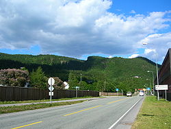
. The European route E6
European route E6
European route E 6 is the designation for the main north-south road in Norway, and the west coast of Sweden, running from the southern tip of Sweden, at Trelleborg, into Norway and through almost all of the country north to Finnmark. The route ends close to the Norwegian border with Russia...
passes through the district. Selfors has been inhabited since the Iron age
Iron Age
The Iron Age is the archaeological period generally occurring after the Bronze Age, marked by the prevalent use of iron. The early period of the age is characterized by the widespread use of iron or steel. The adoption of such material coincided with other changes in society, including differing...
.
The name
The place name Selfors was mentioned in 1430. It has been interpreted as «Sel-foss» (NorwegianNorwegian language
Norwegian is a North Germanic language spoken primarily in Norway, where it is the official language. Together with Swedish and Danish, Norwegian forms a continuum of more or less mutually intelligible local and regional variants .These Scandinavian languages together with the Faroese language...
for «the pinniped waterfall»), a waterfall where pinniped
Pinniped
Pinnipeds or fin-footed mammals are a widely distributed and diverse group of semiaquatic marine mammals comprising the families Odobenidae , Otariidae , and Phocidae .-Overview: Pinnipeds are typically sleek-bodied and barrel-shaped...
s lived. It also has been connected with the Sami word saelhtie (ocean).
The interpretation «Sel-foss» is doubtful. In the old dialect of Rana
Rana, Norway
Rana is the second largest municipality in Nordland county – and the third largest in North Norway – by population. By area, Rana is largest in Norway south of Finnmark , taking in large areas of mountains and forested valleys. It is part of the Helgeland traditional region...
they never used the name «sel» about pinniped
Pinniped
Pinnipeds or fin-footed mammals are a widely distributed and diverse group of semiaquatic marine mammals comprising the families Odobenidae , Otariidae , and Phocidae .-Overview: Pinnipeds are typically sleek-bodied and barrel-shaped...
s, but «købbe». Kobbforsen («Købbforsen»), which literarily means «the pinniped waterfall», is located another place in Rana municipality.
The name can also be seen in connection with sele («silent flowing and deep water»), cf. the Swedish placenames of Lycksele
Lycksele
- References :...
, Sorsele
Sorsele
Sorsele is a locality and the seat of Sorsele Municipality in Västerbotten County, Sweden with 1,288 inhabitants in 2005. Sorsele is also the nearest town to the ski resort Nalovardo.- References :...
and Åsele
Åsele
Åsele is a locality and the seat of Åsele Municipality in Västerbotten County, Sweden with 1,920 inhabitants in 2005. Its elevation is 313 m .- References :...
. Selfors may then mean «a waterfall in a river with silent flowing, deep water». The waterfall is located at Fossetangen, and the «silent flowing, deep water» is Ranelva
Ranelva
Ranelva is a 130 km long river in the municipality of Rana, and is one of the longest rivers in the county of Nordland, Norway. The river begins on Saltfjellet, in the borders between Norway and Sweden, and flows northwestwards under the name Randalselv . Ranelva begins where Randalselva and the...
.
Description
The local division of Helgeland Hospital in Rana, is located on Selfors. Two daycare centres, a primary school and school with secondary classes, are also parts of the infrastructure of the urban district. In connection with the upbuilding of the iron and metal industry company Norsk Jernverk in 1946, Selfors Church was originally built by the Catholic ChurchCatholicism
Catholicism is a broad term for the body of the Catholic faith, its theologies and doctrines, its liturgical, ethical, spiritual, and behavioral characteristics, as well as a religious people as a whole....
. It was built in 1971 and constructed mainly out of glass and wood. It seats 200. It is, however, also used by the Church of Norway
Church of Norway
The Church of Norway is the state church of Norway, established after the Lutheran reformation in Denmark-Norway in 1536-1537 broke the ties to the Holy See. The church confesses the Lutheran Christian faith...
.
In addition, Selfors has a grocery store, which is also running the local post office, a flower shop, a store for hunting, fishing and outdoor life, a petrol station and an inn / public house along European route E6
European route E6
European route E 6 is the designation for the main north-south road in Norway, and the west coast of Sweden, running from the southern tip of Sweden, at Trelleborg, into Norway and through almost all of the country north to Finnmark. The route ends close to the Norwegian border with Russia...
.
There are six housing cooperatives on Selfors, owned by Mo og Omegn Boligbyggelag.
Selfors bridge connects the urban district with Mo i Rana
Mo i Rana
Mo i Rana is a town in the municipality of Rana, Nordland, Norway, located just south of the Arctic Circle and in the region Helgeland. The town is called "Mo i Rana" to distinquish it from other places named Mo - most notably the town of Mosjøen, also in Helgeland - though locally the town is...
. The first bridge on Selfors was built in 1914. On May 18, 1940, it was blown up by the resistance in order to slow down the northward advance of the German occupation forces. It was, however, quickly rebuilt, and was used until it was torn down on March 17, 1965. A new bridge was then built, and is still in use today.
Before the opening of the new bridge between Mjølan and Ytteren, Selfors bridge was the only road communication between Mo i Rana
Mo i Rana
Mo i Rana is a town in the municipality of Rana, Nordland, Norway, located just south of the Arctic Circle and in the region Helgeland. The town is called "Mo i Rana" to distinquish it from other places named Mo - most notably the town of Mosjøen, also in Helgeland - though locally the town is...
and the two urban districts Ytteren and Båsmoen
Båsmoen
Båsmoen is a small village centered 7 kilometres northwest of the town Mo i Rana, Nordland, Norway. Its coordinates are approximately .Båsmoen has grown together with its neighboring village to the east, Ytteren. Both villages are sometimes considered a part of Mo i Rana town area....
.
The hillsides and mountains on Selfors is a popular terrain for outdoor activities. Varmosletta, Skarvatnet and Kvitbergan («the white cliffs») are located in untouched nature.
Selfors farm 1430−1680
Selfors farm is one of the oldests farms in North-Rana and played a central role on the place until 1680. The farm was located at RanelvaRanelva
Ranelva is a 130 km long river in the municipality of Rana, and is one of the longest rivers in the county of Nordland, Norway. The river begins on Saltfjellet, in the borders between Norway and Sweden, and flows northwestwards under the name Randalselv . Ranelva begins where Randalselva and the...
on the western parts of Selfors, near Ranfjord
Ranfjord
The Ranfjord is a fjord in the Helgeland district. The largest part of the fjord is in Rana municipality, Nordland county, Norway. The Ranelva meets the Ranfjord in Mo i Rana at the head of the fjord....
en and Fossetangen.
Selfors farm is mentioned in «the farm book of Aslak Bolt» from 1430, written by Aslak Harniktsson Bolt (ca 1380−1449), archbishop of Nidaros. Aslak Bolt wrote: «af selfosse 1/2 spann» Selfors thus paid 1/2 bucket of butter to the archbishop in the diocese
Diocese
A diocese is the district or see under the supervision of a bishop. It is divided into parishes.An archdiocese is more significant than a diocese. An archdiocese is presided over by an archbishop whose see may have or had importance due to size or historical significance...
of Nidaros
Nidaros
Nidaros or Niðarós was during the Middle Ages, the old name of Trondheim, Norway . Until the Reformation, Nidaros remained the centre of the spiritual life of the country...
.
In the 17th century Selfors farm belonged to Hemnes
Hemnes
Hemnes is a municipality in Nordland county, Norway. It is part of the Helgeland traditional region. The administrative centre of the municipality is the village of Korgen.- Municipality history :...
church.
The Leidang
Leidang
The institution known as leiðangr , leidang , leding, , ledung , expeditio or sometimes lething , was a public levy of free farmers typical for medieval Scandinavians. It was a form of conscription to organise coastal fleets for seasonal excursions and in defence of the realm...
census during the years 1566−1567 does not mention the farm. It had probably not ceased to exist, but was rather forgotten, since the farmer during the census in 1610 was registered as a sailor and in 1612 as a bailiff.