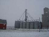
Sedalia, Indiana
Encyclopedia
Sedalia is an unincorporated town
in Owen Township
, Clinton County
, Indiana
, United States
.
March 31, 1873 by James A. Campbell and Jackson B. McCune and was named after Sedalia, Illinois, the home town of an official of the Vandalia Railroad
. McCune built the first house and was the first postmaster. William Miller operated the first store, Allen Branch was the first blacksmith, and Dr. Keeny the first physician.
, half a mile east of State Road 75
.
Unincorporated area
In law, an unincorporated area is a region of land that is not a part of any municipality.To "incorporate" in this context means to form a municipal corporation, a city, town, or village with its own government. An unincorporated community is usually not subject to or taxed by a municipal government...
in Owen Township
Owen Township, Clinton County, Indiana
Owen Township is one of fourteen townships in Clinton County, Indiana. As of the 2000 census, its population was 923. The township was named for Robert Dale Owen of New Harmony.-History:...
, Clinton County
Clinton County, Indiana
As of the census of 2000, there were 33,866 people, 12,545 households, and 9,057 families residing in the county. The population density was 84 people per square mile . There were 13,267 housing units at an average density of 33 per square mile...
, Indiana
Indiana
Indiana is a US state, admitted to the United States as the 19th on December 11, 1816. It is located in the Midwestern United States and Great Lakes Region. With 6,483,802 residents, the state is ranked 15th in population and 16th in population density. Indiana is ranked 38th in land area and is...
, United States
United States
The United States of America is a federal constitutional republic comprising fifty states and a federal district...
.
History
Sedalia was plattedPlat
A plat in the U.S. is a map, drawn to scale, showing the divisions of a piece of land. Other English-speaking countries generally call such documents a cadastral map or plan....
March 31, 1873 by James A. Campbell and Jackson B. McCune and was named after Sedalia, Illinois, the home town of an official of the Vandalia Railroad
Vandalia Railroad (1905-1917)
The Vandalia Railroad was a railroad from Logansport, Indiana, to South Bend, Indiana. It quickly became a property of the Pennsylvania Railroad , which later became part of Penn Central and then Conrail. The railroad was mostly a freight-carrying route with a hub at Logansport Yard...
. McCune built the first house and was the first postmaster. William Miller operated the first store, Allen Branch was the first blacksmith, and Dr. Keeny the first physician.
Geography
Sedalia is located at 40°24′56"N 86°30′53"W along State Road 26Indiana State Road 26
State Road 26 is an east–west road in central Indiana in the United States that crosses the entire state from east to west, covering a distance of about .-Route description:...
, half a mile east of State Road 75
Indiana State Road 75
State Road 75, the highest two-digit route in the U.S. state of Indiana consists of two discontinuous north–south segments.-Southern section:...
.

