
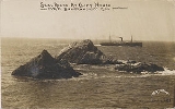
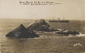
Seal Rock
Encyclopedia
Seal Rocks is a rock formation
island
found offshore at the north end of the Ocean Beach, San Francisco, California
. Its name is derived from the population of Steller's sea lion
s (Eumetopias jubatus) and California sea lion
s (Zalophus californianus) who used to haul out on the rock. Both species are often colloquially called "seals".
 Near the end of the last ice age
, this part of the coastline was thought to be between eight and twenty five miles westward of its current position - around five thousand years ago, with the melting of the ice, the sea level rose to its current level.
The coastal features found here today were formed by the actions of waves, wind, and the movement of sand. The geology of this part of the coastline of San Francisco consists of steep rocky cliffs which are punctuated by narrow sandy pocket beaches found at the north end of the city and long sandy stretches at Ocean Beach and Fort Funston
to the south.
The local features, and indeed the entire San Francisco Peninsula
, come from the northern aspect of the Santa Cruz Mountains
. Before the urban development seen today, the area landward of Ocean Beach consisted of barren sand fields inland to Twin Peaks
. The first known map of the area, dating from 1852, was made by the U.S. Coast and Geodetic Survey
and describes the coastline here as being entirely unaltered by humans.
The geologic layers beneath Ocean Beach, starting from the top (i.e. the youngest), are:
The Colma and Merced Formations consist generally of poorly-sorted sandy deposits, probably deposited during some earlier period of greater sea levels. The Colma Formation is found under the dune sands and also extends inland.
Rock formations in the United States
The following is a partial list of rock formations in the United States, by state:-Arizona:*Canyon de Chelly National Monument**Spider Rock*Chiricahua National Monument**Duck on a Rock**Organ Pipe**Mushroom Rock**Sea Captain*Monument Valley...
island
Island
An island or isle is any piece of sub-continental land that is surrounded by water. Very small islands such as emergent land features on atolls can be called islets, cays or keys. An island in a river or lake may be called an eyot , or holm...
found offshore at the north end of the Ocean Beach, San Francisco, California
Ocean Beach, San Francisco, California
Ocean Beach is a beach that runs along the west coast of San Francisco, California, United States, at the Pacific Ocean. It is adjacent to Golden Gate Park, the Richmond District and the Sunset District. The Great Highway runs alongside the beach, and Cliff House and the site of the former Sutro...
. Its name is derived from the population of Steller's sea lion
Steller's Sea Lion
The Steller sea lion also known as the northern sea lion, is a threatened species of sea lion in the northern Pacific. It is the sole member of the genus Eumetopias and the largest of the eared seals . Among pinnipeds, it is inferior in size only to the walrus and the two elephant seals...
s (Eumetopias jubatus) and California sea lion
California Sea Lion
The California sea lion is a coastal sea lion of western North America. Their numbers are abundant , and the population continues to expand about 5% annually. They are quite intelligent and can adapt to man-made environments...
s (Zalophus californianus) who used to haul out on the rock. Both species are often colloquially called "seals".
Geology
Ice age
An ice age or, more precisely, glacial age, is a generic geological period of long-term reduction in the temperature of the Earth's surface and atmosphere, resulting in the presence or expansion of continental ice sheets, polar ice sheets and alpine glaciers...
, this part of the coastline was thought to be between eight and twenty five miles westward of its current position - around five thousand years ago, with the melting of the ice, the sea level rose to its current level.
The coastal features found here today were formed by the actions of waves, wind, and the movement of sand. The geology of this part of the coastline of San Francisco consists of steep rocky cliffs which are punctuated by narrow sandy pocket beaches found at the north end of the city and long sandy stretches at Ocean Beach and Fort Funston
Fort Funston
Fort Funston is a protected area within the Golden Gate National Recreation Area at the southwestern corner of San Francisco. It occupies windswept headlands along the Pacific coast, steep cliffs and the beach below...
to the south.
The local features, and indeed the entire San Francisco Peninsula
San Francisco Peninsula
The San Francisco Peninsula is a peninsula in the San Francisco Bay Area that separates the San Francisco Bay from the Pacific Ocean. On its northern tip is the City and County of San Francisco. Its southern base is in Santa Clara County, including the cities of Palo Alto, Los Altos, and Mountain...
, come from the northern aspect of the Santa Cruz Mountains
Santa Cruz Mountains
The Santa Cruz Mountains, part of the Pacific Coast Ranges, are a mountain range in central California, United States. They form a ridge along the San Francisco Peninsula, south of San Francisco, separating the Pacific Ocean from San Francisco Bay and the Santa Clara Valley, and continuing south,...
. Before the urban development seen today, the area landward of Ocean Beach consisted of barren sand fields inland to Twin Peaks
Twin Peaks, San Francisco, California
The Twin Peaks are two hills with an elevation of about near the geographic center of San Francisco, California. Except for Mount Davidson, they are the highest points in the city.-Location and climate:...
. The first known map of the area, dating from 1852, was made by the U.S. Coast and Geodetic Survey
U.S. National Geodetic Survey
National Geodetic Survey, formerly called the U.S. Coast and Geodetic Survey , is a United States federal agency that defines and manages a national coordinate system, providing the foundation for transportation and communication; mapping and charting; and a large number of applications of science...
and describes the coastline here as being entirely unaltered by humans.
The geologic layers beneath Ocean Beach, starting from the top (i.e. the youngest), are:
- Placed fill, from various construction activities over the last 100 years or so. The depth of this placed fill varies, but in 1985 it was then estimated to be between 7 to 16 ft (2.1 to 4.9 ) deep.
- DuneDuneIn physical geography, a dune is a hill of sand built by wind. Dunes occur in different forms and sizes, formed by interaction with the wind. Most kinds of dunes are longer on the windward side where the sand is pushed up the dune and have a shorter "slip face" in the lee of the wind...
sands, estimated to be 13 to 26 ft (4 to 7.9 ) deep. - Colma Formation
- Merced Formation
- BedrockBedrockIn stratigraphy, bedrock is the native consolidated rock underlying the surface of a terrestrial planet, usually the Earth. Above the bedrock is usually an area of broken and weathered unconsolidated rock in the basal subsoil...
. The depth to bedrock is estimated to be between 350 to 400 ft (106.7 to 121.9 ).
The Colma and Merced Formations consist generally of poorly-sorted sandy deposits, probably deposited during some earlier period of greater sea levels. The Colma Formation is found under the dune sands and also extends inland.
See also
- 49-Mile Scenic Drive49-Mile Scenic DriveThe 49-Mile Scenic Drive in San Francisco highlights many of the city's major attractions and historic structures.Opened on September 14, 1938 as a promotion for the 1939 Golden Gate International Exposition, it...
- Cliff House, San FranciscoCliff House, San FranciscoThe Cliff House is a restaurant perched on the headlands on the cliffs just north of Ocean Beach on the western side of San Francisco, California...
, an adjacent tourist attraction - List of islands of California