
Saronida
Encyclopedia
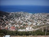
Saronida is a village and a former community in Attica
, Greece
. Since the 2011 local government reform it is part of the municipality Saronikos
, of which it is a municipal unit.
city center on the Athens–Sounion
Road GR-91
. One can visit the city either by an urban bus service, (line number E22), or a suburban bus service on its way to Sounion. It is mainly a summer residential area with plenty of amenities, restaurants, bars and market. Saronida's main beach is one of the most clear beaches of Attica. Saronida is located approximately 45 km SE of Athens
, S of the Eleftherios Venizelos International Airport and the Attiki Odos
(numbers 6 and 62), NW of Cape Sounio and south of the Hymettus Ring.
The residential areas on the Saronic
coastline as well as on to the mountain sides are mainly in grid with a mixture of small, second homes and luxury homes or low and middle density homes with swimming pools and backyards. Suburban housing arrived in the 1980s and continued into the 1990s and slowly continuing to this day.
The mountains cover the eastern part of the municipal unit, consisting of rocks and grasslands. Forests lie to the south on a small hill, farmlands now cover the north, the rest of the area is covered with residential buildings. A fraction of the population are still rural.
Attica
Attica is a historical region of Greece, containing Athens, the current capital of Greece. The historical region is centered on the Attic peninsula, which projects into the Aegean Sea...
, Greece
Greece
Greece , officially the Hellenic Republic , and historically Hellas or the Republic of Greece in English, is a country in southeastern Europe....
. Since the 2011 local government reform it is part of the municipality Saronikos
Saronikos, Attica
Saronikos is a municipality in the East Attica regional unit, Attica, Greece. The seat of the municipality is the town Kalyvia Thorikou.-Municipality:...
, of which it is a municipal unit.
Geography
It lies 45 km from AthensAthens
Athens , is the capital and largest city of Greece. Athens dominates the Attica region and is one of the world's oldest cities, as its recorded history spans around 3,400 years. Classical Athens was a powerful city-state...
city center on the Athens–Sounion
Sounion
Cape Sounion is a promontory located SSE of Athens, at the southernmost tip of the Attica peninsula in Greece.Cape Sounion is noted as the site of ruins of an ancient...
Road GR-91
Greek National Road 91
Greek National Road 91 is a highway running from the southernmost limit of the Athens metropolitan Area, in Vouliagmeni up to Sounio. It is a continuation of Poseidonos Avenue . It was first constructed in the 1950s as a one lane per direction road, but was later extended to two lanes per...
. One can visit the city either by an urban bus service, (line number E22), or a suburban bus service on its way to Sounion. It is mainly a summer residential area with plenty of amenities, restaurants, bars and market. Saronida's main beach is one of the most clear beaches of Attica. Saronida is located approximately 45 km SE of Athens
Athens
Athens , is the capital and largest city of Greece. Athens dominates the Attica region and is one of the world's oldest cities, as its recorded history spans around 3,400 years. Classical Athens was a powerful city-state...
, S of the Eleftherios Venizelos International Airport and the Attiki Odos
Attiki Odos
Attiki Odos is a privately owned toll motorway in Greece. The Proastiakos high-speed suburban rail is set almost entirely in the median of the motorway, along its main section. The motorway's numbers are 6 for the main section, 64 for the Hymettus Beltway and 65 for the Aigaleo Beltway...
(numbers 6 and 62), NW of Cape Sounio and south of the Hymettus Ring.
The residential areas on the Saronic
Saronic Gulf
The Saronic Gulf or Gulf of Aegina in Greece forms part of the Aegean Sea and defines the eastern side of the isthmus of Corinth. It is the eastern terminus of the Corinth Canal, which cuts across the isthmus.-Geography:The gulf includes the islands of; Aegina, Salamis, and Poros along with...
coastline as well as on to the mountain sides are mainly in grid with a mixture of small, second homes and luxury homes or low and middle density homes with swimming pools and backyards. Suburban housing arrived in the 1980s and continued into the 1990s and slowly continuing to this day.
The mountains cover the eastern part of the municipal unit, consisting of rocks and grasslands. Forests lie to the south on a small hill, farmlands now cover the north, the rest of the area is covered with residential buildings. A fraction of the population are still rural.
Historical population
| Year | Population |
|---|---|
| 1981 | 733 |
| 1991 | 1,572 |
| 2001 | 2,102 |