
Santa Clara, New York
Encyclopedia
Santa Clara is a town
in Franklin County
, New York
, United States
. The population was 395 at the 2000 census. The name was derived from the wife of an early town businessman, John Hurd.
The Town of Santa Clara is in the southwest part of the county and is southwest of the Village of Malone
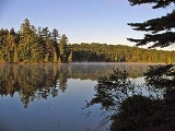
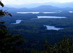
The town is within the Adirondack Park. It includes the 58 ponds of the Saint Regis Canoe Area
, presently the only Canoe Wilderness Area in the park, as well as most of 4700 acres (19 km²) Upper Saranac Lake
.
in 1888. An addition from Brandon was added to Santa Clara in 1896.
William Rockefeller
began buying property in the town around 1896 in order of establish an estate, used by members of his family during the summer.
, the town has a total area of 191.7 square miles (496.5 km²), of which, 175 square miles (453.2 km²) of it is land and 16.7 square miles (43.3 km²) of it (8.71%) is water.
Santa Clara is the second largest town in the county. The south part of the town is dominated by numerous lake
s.
New York State Route 458
is a north-south highway in Santa Clara. New York State Route 30
crosses the south part of the town.
The St. Regis River
flows out the west town line.
of 2000, there were 395 people, 155 households, and 119 families residing in the town. The population density
was 2.3 people per square mile (0.9/km²). There were 953 housing units at an average density of 5.4 per square mile (2.1/km²). The racial makeup of the town was 96.20% White, 0.25% African American, 1.77% Native American, 0.25% Asian, 0.76% from other races
, and 0.76% from two or more races.
There were 155 households out of which 31.6% had children under the age of 18 living with them, 63.2% were married couples
living together, 9.0% had a female householder with no husband present, and 22.6% were non-families. 20.0% of all households were made up of individuals and 8.4% had someone living alone who was 65 years of age or older. The average household size was 2.55 and the average family size was 2.90.
In the town the population was spread out with 25.1% under the age of 18, 4.3% from 18 to 24, 23.5% from 25 to 44, 31.1% from 45 to 64, and 15.9% who were 65 years of age or older. The median age was 43 years. For every 100 females there were 110.1 males. For every 100 females age 18 and over, there were 105.6 males.
The median income for a household in the town was $42,083, and the median income for a family was $45,750. Males had a median income of $30,000 versus $24,688 for females. The per capita income
for the town was $19,683. About 8.3% of families and 7.4% of the population were below the poverty line, including 10.5% of those under age 18 and 6.6% of those age 65 or over.
Town
A town is a human settlement larger than a village but smaller than a city. The size a settlement must be in order to be called a "town" varies considerably in different parts of the world, so that, for example, many American "small towns" seem to British people to be no more than villages, while...
in Franklin County
Franklin County, New York
Franklin County is a county located in the U.S. state of New York. As of the 2010 census, the population was 51,599. It is named in honor of American Founding Father Benjamin Franklin...
, New York
New York
New York is a state in the Northeastern region of the United States. It is the nation's third most populous state. New York is bordered by New Jersey and Pennsylvania to the south, and by Connecticut, Massachusetts and Vermont to the east...
, United States
United States
The United States of America is a federal constitutional republic comprising fifty states and a federal district...
. The population was 395 at the 2000 census. The name was derived from the wife of an early town businessman, John Hurd.
The Town of Santa Clara is in the southwest part of the county and is southwest of the Village of Malone
Malone (village), New York
-Notable natives:Notable natives include:*William Almon Wheeler served as Vice President of the United States under Rutherford Hayes. Is buried at Morningside Cemetery in Malone....
The town is within the Adirondack Park. It includes the 58 ponds of the Saint Regis Canoe Area
Saint Regis Canoe Area
The Saint Regis Canoe Area is a 19,000 acre area of the Adirondack Park in southern Franklin County, New York about 18 miles northeast of Tupper Lake and southwest of Paul Smiths....
, presently the only Canoe Wilderness Area in the park, as well as most of 4700 acres (19 km²) Upper Saranac Lake
Upper Saranac Lake
Upper Saranac Lake is one of three connected lakes, part of the Saranac River, in the towns of Santa Clara and Harrietstown, near the village of Saranac Lake in the Adirondacks in northern New York. Upper Saranac Lake is the sixth largest lake in the Adirondacks. With Middle Saranac Lake and...
.
History
The Town of Santa Clara was formed from part of the Town of BrandonBrandon, New York
Brandon is a town in Franklin County, New York, United States. It is centrally located in the county, southwest of the village of Malone. The town population was 542 at the 2000 census. It was named after Brandon, Vermont by early settlers.-History:...
in 1888. An addition from Brandon was added to Santa Clara in 1896.
William Rockefeller
William Rockefeller
William Avery Rockefeller, Jr. , American financier, was a co-founder with his older brother John D. Rockefeller of the prominent United States Rockefeller family. He was the son of William Avery Rockefeller, Sr. and Eliza Rockefeller.-Youth, education:Rockefeller was born in Richford, New York,...
began buying property in the town around 1896 in order of establish an estate, used by members of his family during the summer.
Geography
According to the United States Census BureauUnited States Census Bureau
The United States Census Bureau is the government agency that is responsible for the United States Census. It also gathers other national demographic and economic data...
, the town has a total area of 191.7 square miles (496.5 km²), of which, 175 square miles (453.2 km²) of it is land and 16.7 square miles (43.3 km²) of it (8.71%) is water.
Santa Clara is the second largest town in the county. The south part of the town is dominated by numerous lake
Lake
A lake is a body of relatively still fresh or salt water of considerable size, localized in a basin, that is surrounded by land. Lakes are inland and not part of the ocean and therefore are distinct from lagoons, and are larger and deeper than ponds. Lakes can be contrasted with rivers or streams,...
s.
New York State Route 458
New York State Route 458
New York State Route 458 is a state highway in the North Country of New York, United States. This highway runs northwest to southeast from St. Lawrence County into adjacent Franklin County. The western terminus is at NY 11B in the Hopkinton near the Lawrence hamlet of Nicholville...
is a north-south highway in Santa Clara. New York State Route 30
New York State Route 30
New York State Route 30 is a state highway in the central part of New York in the United States. It extends for from an interchange with NY 17 in the Southern Tier to the Canadian border in the state's North Country, where it continues into Quebec as Route 138. On a regional level,...
crosses the south part of the town.
The St. Regis River
St. Regis River
The St. Regis River is an river in northern New York in the USA. It flows into the Saint Lawrence River at the hamlet of St Regis in the St. Regis Mohawk Reservation. The Saint Regis River basin includes Upper and Lower St. Regis Lakes, and Saint Regis Pond in the Saint Regis Canoe Area.-External...
flows out the west town line.
Demographics
As of the censusCensus
A census is the procedure of systematically acquiring and recording information about the members of a given population. It is a regularly occurring and official count of a particular population. The term is used mostly in connection with national population and housing censuses; other common...
of 2000, there were 395 people, 155 households, and 119 families residing in the town. The population density
Population density
Population density is a measurement of population per unit area or unit volume. It is frequently applied to living organisms, and particularly to humans...
was 2.3 people per square mile (0.9/km²). There were 953 housing units at an average density of 5.4 per square mile (2.1/km²). The racial makeup of the town was 96.20% White, 0.25% African American, 1.77% Native American, 0.25% Asian, 0.76% from other races
Race (United States Census)
Race and ethnicity in the United States Census, as defined by the Federal Office of Management and Budget and the United States Census Bureau, are self-identification data items in which residents choose the race or races with which they most closely identify, and indicate whether or not they are...
, and 0.76% from two or more races.
There were 155 households out of which 31.6% had children under the age of 18 living with them, 63.2% were married couples
Marriage
Marriage is a social union or legal contract between people that creates kinship. It is an institution in which interpersonal relationships, usually intimate and sexual, are acknowledged in a variety of ways, depending on the culture or subculture in which it is found...
living together, 9.0% had a female householder with no husband present, and 22.6% were non-families. 20.0% of all households were made up of individuals and 8.4% had someone living alone who was 65 years of age or older. The average household size was 2.55 and the average family size was 2.90.
In the town the population was spread out with 25.1% under the age of 18, 4.3% from 18 to 24, 23.5% from 25 to 44, 31.1% from 45 to 64, and 15.9% who were 65 years of age or older. The median age was 43 years. For every 100 females there were 110.1 males. For every 100 females age 18 and over, there were 105.6 males.
The median income for a household in the town was $42,083, and the median income for a family was $45,750. Males had a median income of $30,000 versus $24,688 for females. The per capita income
Per capita income
Per capita income or income per person is a measure of mean income within an economic aggregate, such as a country or city. It is calculated by taking a measure of all sources of income in the aggregate and dividing it by the total population...
for the town was $19,683. About 8.3% of families and 7.4% of the population were below the poverty line, including 10.5% of those under age 18 and 6.6% of those age 65 or over.
Communities and locations in Santa Clara
- Bay Pond – A hamlet in the south-central part of the town. It was a former Rockefeller summer home.
- Brandon – A former community, located north of Bay Pond. It became part of the Rockefeller estate and its buildings were removed.
- Derrick – A hamlet west of Saranac Inn.
- Everton – A former community abandoned after the forests had been stripped.
- Floodwood – A hamlet west of Saranac Inn near the west town line.
- Kildare – A hamlet west of Saranac Inn near the west town line.
- Madawaska – A hamletHamlet (place)A hamlet is usually a rural settlement which is too small to be considered a village, though sometimes the word is used for a different sort of community. Historically, when a hamlet became large enough to justify building a church, it was then classified as a village...
near the east town line. - Madawaska Pond – A lake near the center of the town.
- Middle Saranac LakeMiddle Saranac LakeMiddle Saranac Lake, also called Round Lake, is the smallest of three connected lakes, part of the Saranac River, near the village of Saranac Lake in the Adirondacks in northern New York. Two-thirds of its shoreline is state-owned...
– Part of the lake is in the southeast corner of the town. - Meno – A location northeast of Madawaska.
- The Saint Regis Canoe AreaSaint Regis Canoe AreaThe Saint Regis Canoe Area is a 19,000 acre area of the Adirondack Park in southern Franklin County, New York about 18 miles northeast of Tupper Lake and southwest of Paul Smiths....
– A 19000 acres (76.9 km²) wilderness area with 58 ponds (no motorized vehicles are allowed). - Santa Clara – the hamlet of Santa Clara is near the west town line in the northern part of the town on NY-458.
- Saranac InnSaranac InnThe Saranac Inn was a large, luxurious hotel located on a peninsula at the northern end of the Upper Saranac Lake in the town of Santa Clara in the Adirondacks in New York State, USA. It was frequented by US Presidents Grover Cleveland and Chester A. Arthur and New York Governor Charles Evans Hughes...
(also "Upper Saranac") – A hamlet in the south part of the town. - Saranac Inn Station – A location east of Saranac Inn.
- Spring Cove – A hamlet near the west town line, south of Santa Clara village.
- Upper Saranac LakeUpper Saranac LakeUpper Saranac Lake is one of three connected lakes, part of the Saranac River, in the towns of Santa Clara and Harrietstown, near the village of Saranac Lake in the Adirondacks in northern New York. Upper Saranac Lake is the sixth largest lake in the Adirondacks. With Middle Saranac Lake and...
– Most of the lake is in the south part of the town. - Weller PondWeller PondWeller Pond is a wilderness pond southwest of the village of Saranac Lake in the Adirondacks in northern New York. It is connected to Middle Saranac Lake and is entirely state-owned. It sits in the shadow of Boot Bay Mountain; there is a canoe carry to Upper Saranac Lake...
– A large pond in the southern part of the town.