
Saint Regis Canoe Area
Encyclopedia
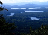
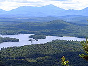
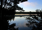
The Saint Regis Canoe Area is a 19,000 acre (76 km²) area of the Adirondack Park in southern Franklin County, New York
about 18 miles (29 km) northeast of Tupper Lake
and southwest of Paul Smiths
.
It is the largest wilderness
canoe
area in the Northeast
and the only designated canoe area in New York state; it is closed to motor vehicles, motor boats and aircraft. There are 58 ponds and the headwaters of the West and Middle Branch of the Saint Regis
and the Saranac River
s. Only two of the ponds can be reached without a carry
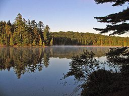
. The area is noted for its beauty, wilderness and short canoe carries. Primitive canoe camping
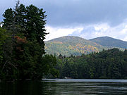
is permitted on many of the lakes and ponds. Saint Regis Mountain
(2874 ft) and Long Pond Mountain (2530 ft) are within the Canoe Area. The trail to Long Pond Mountain can only be reached by water.
Note: the put ins and take outs and the carry trails can be very muddy at any time of year, and black flies
can be extremely active in the spring and early summer.
There are also a number of unnamed ponds in the Canoe Area.
Franklin County, New York
Franklin County is a county located in the U.S. state of New York. As of the 2010 census, the population was 51,599. It is named in honor of American Founding Father Benjamin Franklin...
about 18 miles (29 km) northeast of Tupper Lake
Tupper Lake
Tupper Lake is the name of several locations in the State of New York in the USA.* Tupper Lake, a lake in the Adirondack Park.* Village of Tupper Lake.* Town of Tupper Lake....
and southwest of Paul Smiths
Paul Smiths, New York
Paul Smiths is a hamlet in the Town of Brighton in Franklin County, New York, on Lower Saint Regis Lake, in the Adirondacks, 10 miles north of Saranac Lake, located at 44°26' North 74°15' West....
.
It is the largest wilderness
Wilderness
Wilderness or wildland is a natural environment on Earth that has not been significantly modified by human activity. It may also be defined as: "The most intact, undisturbed wild natural areas left on our planet—those last truly wild places that humans do not control and have not developed with...
canoe
Canoe
A canoe or Canadian canoe is a small narrow boat, typically human-powered, though it may also be powered by sails or small electric or gas motors. Canoes are usually pointed at both bow and stern and are normally open on top, but can be decked over A canoe (North American English) or Canadian...
area in the Northeast
Northeastern United States
The Northeastern United States is a region of the United States as defined by the United States Census Bureau.-Composition:The region comprises nine states: the New England states of Connecticut, Maine, Massachusetts, New Hampshire, Rhode Island and Vermont; and the Mid-Atlantic states of New...
and the only designated canoe area in New York state; it is closed to motor vehicles, motor boats and aircraft. There are 58 ponds and the headwaters of the West and Middle Branch of the Saint Regis
St. Regis River
The St. Regis River is an river in northern New York in the USA. It flows into the Saint Lawrence River at the hamlet of St Regis in the St. Regis Mohawk Reservation. The Saint Regis River basin includes Upper and Lower St. Regis Lakes, and Saint Regis Pond in the Saint Regis Canoe Area.-External...
and the Saranac River
Saranac River
Saranac River is an river in the U.S. state of New York. In its upper reaches is a region of mostly flat water and lakes. The river has more than three dozen source lakes and ponds north of Upper Saranac Lake; the highest is Mountain Pond on Long Pond Mountain...
s. Only two of the ponds can be reached without a carry
Portage
Portage or portaging refers to the practice of carrying watercraft or cargo over land to avoid river obstacles, or between two bodies of water. A place where this carrying occurs is also called a portage; a person doing the carrying is called a porter.The English word portage is derived from the...
. The area is noted for its beauty, wilderness and short canoe carries. Primitive canoe camping
Canoe camping
Canoe camping is a combination of canoeing and camping. It is similar to backpacking, but canoe campers travel by canoes or kayaks...
is permitted on many of the lakes and ponds. Saint Regis Mountain
Saint Regis Mountain
Saint Regis Mountain is a mountain in the town of Santa Clara, New York, in Franklin County at the center of the Saint Regis Canoe Area in the Adirondack Park....
(2874 ft) and Long Pond Mountain (2530 ft) are within the Canoe Area. The trail to Long Pond Mountain can only be reached by water.
Note: the put ins and take outs and the carry trails can be very muddy at any time of year, and black flies
Black fly
A black fly is any member of the family Simuliidae of the Culicomorpha infraorder. They are related to the Ceratopogonidae, Chironomidae, and Thaumaleidae. There are over 1,800 known species of black flies . Most species belong to the immense genus Simulium...
can be extremely active in the spring and early summer.
Ponds
- Bear Pond - two short carries from Upper Saint Regis Lake via tiny Bog Pond, Bear pond is part of the Seven CarriesSeven Carries.The Seven Carries is an historic canoe route from Paul Smith's Hotel to the Saranac Inn through what is now known as the Saint Regis Canoe Area in southern Franklin County, New York in the Adirondack Park...
route. - Bessie Pond - Reached via a 1.5 miles (2.4 km) carry from Long Pond, one of the longer carries in the Canoe Area. One campsiteCampsiteA campsite or camping pitch is a place used for overnight stay in the outdoors. In British English a campsite is an area, usually divided into a number of pitches, where people can camp overnight using tents or camper vans or caravans; this British English use of the word is synonymous with the...
. - Bone Pond - A very small, rather isolated pond.
- Clamshell Pond - Part of a route from Turtle Pond to Fish Pond; the route has been closed due to beaver activity.
- East Pond - A small pond accessible only by bushwhacking.
- Fish Pond - A medium-sized pond that can be reached by relatively lengthy carries from Long Pond or Saint Regis Pond. Five campsites, two lean-tos.
- Grass Pond - A small pond with two campsites. A beaver stronghold.
- Green Pond - part of the Seven Carries route; oddly, Green Pond is smaller than Little Green Pond.
- Kit Fox Pond - A small pond; part of one route from Long Pond to Fish Pond.
- Ledge Pond - Can be reached by a short carry from Pink Pond.
- Little Green Pond - one of two ponds in the canoe area that do not require a carry to reach; start of the traditional Seven Carries.
- Little Clear Pond - the other pond that does not require a carry to reach; alternate start of the Seven Carries. No fishing or camping.
- Little Long Pond (west of Fish Pond) - Part of one route from Long Pond to Fish Pond.
- Little Long Pond (east of St. Regis Pond) - part of the Seven Carries route.
- Long Pond - at 2 miles (3.2 km) long and 338 acres (1.4 km²), the second largest pond, with two islands. Reached by 0.25 carry from Floodwood Road, 18 campsites.
- Lydia Pond - A small pond, one of the most remote in the Canoe Area; one campsite.
- Monday Pond - A very small pond with one campsite.
- Mountain Pond - A small pond on the trail from Long Pond to Long Pond Mountain.
- Mud Pond - A small pond; part of the route from Saint Regis Pond to Fish Pond, via a carry from Ochre Pond.
- Nellie Pond - Reached via a 1.7 miles (2.7 km) carry from Long Pond, one of the longest carries in the Canoe Area. No campsites.
- Ochre Pond - Part of the route from Saint Regis Pond to Fish Pond.
- Pink Pond - Reachable in high water from Long Pond, no campsites.
- Roiley Pond - A small, isolated pond near the eastern end of the Canoe Area
- Saint Regis PondSaint Regis PondSaint Regis Pond is a pond, the largest in the Saint Regis Canoe Area in the Adirondacks in northern New York state. It drains into the west branch of the St. Regis River. It is the centerpiece of the "Seven Carries" canoe route....
- 400 acres (1.6 km²), the largest pond in the canoe area, with four islands. 14 campsites. - Slang Pond - A small pond, reachable by a 0.15 mile (0.241401 km) carry from Long Pond; connects to Turtle Pond. Two campsites.
- Turtle Pond - A small pond that connects Slang Pond to Hoel Pond (just outside of the Canoe Area.
There are also a number of unnamed ponds in the Canoe Area.
Sources
Jamieson, Paul and Morris, Donald, Adirondack Canoe Waters, North Flow, Lake George, NY: Adirondack Mountain Club, 1987. ISBN 0-935272-43-7.