
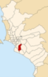
San Juan de Miraflores
Encyclopedia
San Juan de Miraflores is a district
of the Lima Province
in Peru
. It is located in the Cono Sur area of the city of Lima
.
Officially established as a district on January 12, 1965, the current mayor
(alcalde
) of San Juan de Miraflores is Edilberto Quispe Rodriguez. The district's postal code
is 29.
San Juan de Miraflores is one of the pueblos nuevos, or new towns, that have been formed by the massive numbers of people moving from other towns of Metropolitan Lima (such as Miraflores, Surquillo, La Victoria, among others) and from the countryside. Basically, people who were from the capital could afford building their new houses, actually , back in the early 60's, SJM was mostly a desertic area. SJM, is divided in zones ("A", "B", "C", "D", "E" and "K") In the early 80's people from Cuzco, Ayacucho, Pasco, and many of the other departments that were under the attack of terrorists, chose SJM and Villa el Salvador as their new home. As new residents were coming into SJM, two new zones were created: Pamplona Alta and Pamplona Baja. This name was taken in honor of some of the Spanish missionaries (who were from Pamplona, Spain) who offered their help to the residents. One of Pamplona Alta's mains streets, "Pista Nueva" or "New Street", is an example of how new the area is. When it was first settled, many people lived without electricity, water or plumbing, often building their houses from reed mats into the steep hills, with treacherous paths leading to the houses at the top. As residents could afford building materials, they would begin to reinforce these reed mats with plywood, bricks, or whatever else they could find.
Today the houses are a hodgepodge of building materials, most in a state of continual construction as residents can afford each additional brick. Most have access to electricity, but many still lack running water or plumbing. In just the last couple of years the mayor of Lima has launched an extremely successful program to build concrete staircases "escaleras" into the hillsides, replacing the treacherous paths and dramatically improving the living conditions of residents. These staircases are distinctively painted yellow, with bright blue signs, and neighborhood residents are hired by the city to build them.
In addition to these new zones, 2 more were created. By the year 1981, America and Umamarca were created, usually these new zones are well known because of its highly interest of being better every day, since most of the owners are the people who worked most of their lives (and still do) in Ciudad de Dios' Market. They urbanized these areas really quick.
By 1983 and 1984, two new more zones were created, these are Maria Auxiliadora and Amauta ("teacher" in English), it's located between zones "A" and "B". One of the main streets of Maria Auxiliadora is Pedro Miotta, which was well known as the former Panamericana Sur freeway.
Within Lima, particularly in public transportation terms, "San Juan" generally refers to San Juan de Miraflores; San Juan de Lurigancho
, which is north of the Rímac River
and is of larger size, is denoted by its individual sections, such as Zárate, Campoy, Mangomarca, Canto Grande, etc.
of 23.98 km². Its administrative center is located 141 meters above sea level
.
by the INEI
, the district has 335,237 inhabitants, a population density of 13,979.9 persons/km² and 71,384 households.
Districts of Peru
The districts of Peru are the third-level country subdivisions of Peru. They are subdivisions of the provinces, which in turn are subdivisions of the larger regions or departments...
of the Lima Province
Lima Province
Lima Province is located in the central coast of Peru and is the only province in the country not belonging to any of the twenty-five regions. Its capital is Lima, which is also the nation's capital....
in Peru
Peru
Peru , officially the Republic of Peru , is a country in western South America. It is bordered on the north by Ecuador and Colombia, on the east by Brazil, on the southeast by Bolivia, on the south by Chile, and on the west by the Pacific Ocean....
. It is located in the Cono Sur area of the city of Lima
Lima
Lima is the capital and the largest city of Peru. It is located in the valleys of the Chillón, Rímac and Lurín rivers, in the central part of the country, on a desert coast overlooking the Pacific Ocean. Together with the seaport of Callao, it forms a contiguous urban area known as the Lima...
.
Officially established as a district on January 12, 1965, the current mayor
Mayor
In many countries, a Mayor is the highest ranking officer in the municipal government of a town or a large urban city....
(alcalde
Alcalde
Alcalde , or Alcalde ordinario, is the traditional Spanish municipal magistrate, who had both judicial and administrative functions. An alcalde was, in the absence of a corregidor, the presiding officer of the Castilian cabildo and judge of first instance of a town...
) of San Juan de Miraflores is Edilberto Quispe Rodriguez. The district's postal code
Postal code
A postal code is a series of letters and/or digits appended to a postal address for the purpose of sorting mail. Once postal codes were introduced, other applications became possible.In February 2005, 117 of the 190 member countries of the Universal Postal Union had postal code systems...
is 29.
San Juan de Miraflores is one of the pueblos nuevos, or new towns, that have been formed by the massive numbers of people moving from other towns of Metropolitan Lima (such as Miraflores, Surquillo, La Victoria, among others) and from the countryside. Basically, people who were from the capital could afford building their new houses, actually , back in the early 60's, SJM was mostly a desertic area. SJM, is divided in zones ("A", "B", "C", "D", "E" and "K") In the early 80's people from Cuzco, Ayacucho, Pasco, and many of the other departments that were under the attack of terrorists, chose SJM and Villa el Salvador as their new home. As new residents were coming into SJM, two new zones were created: Pamplona Alta and Pamplona Baja. This name was taken in honor of some of the Spanish missionaries (who were from Pamplona, Spain) who offered their help to the residents. One of Pamplona Alta's mains streets, "Pista Nueva" or "New Street", is an example of how new the area is. When it was first settled, many people lived without electricity, water or plumbing, often building their houses from reed mats into the steep hills, with treacherous paths leading to the houses at the top. As residents could afford building materials, they would begin to reinforce these reed mats with plywood, bricks, or whatever else they could find.
Today the houses are a hodgepodge of building materials, most in a state of continual construction as residents can afford each additional brick. Most have access to electricity, but many still lack running water or plumbing. In just the last couple of years the mayor of Lima has launched an extremely successful program to build concrete staircases "escaleras" into the hillsides, replacing the treacherous paths and dramatically improving the living conditions of residents. These staircases are distinctively painted yellow, with bright blue signs, and neighborhood residents are hired by the city to build them.
In addition to these new zones, 2 more were created. By the year 1981, America and Umamarca were created, usually these new zones are well known because of its highly interest of being better every day, since most of the owners are the people who worked most of their lives (and still do) in Ciudad de Dios' Market. They urbanized these areas really quick.
By 1983 and 1984, two new more zones were created, these are Maria Auxiliadora and Amauta ("teacher" in English), it's located between zones "A" and "B". One of the main streets of Maria Auxiliadora is Pedro Miotta, which was well known as the former Panamericana Sur freeway.
Within Lima, particularly in public transportation terms, "San Juan" generally refers to San Juan de Miraflores; San Juan de Lurigancho
San Juan de Lurigancho
San Juan de Lurigancho is a district in Lima, Peru, located in the area known as Cono Este. It is sometimes referred to as simple "SJL" on various forms of transportation...
, which is north of the Rímac River
Rímac River
The Rímac River is located in western Peru and is the most important source of potable water for the Lima and Callao Metropolitan Area.The river is part of the Pacific watershed and has a length of 160 km...
and is of larger size, is denoted by its individual sections, such as Zárate, Campoy, Mangomarca, Canto Grande, etc.
Geography
The district has a total land areaArea
Area is a quantity that expresses the extent of a two-dimensional surface or shape in the plane. Area can be understood as the amount of material with a given thickness that would be necessary to fashion a model of the shape, or the amount of paint necessary to cover the surface with a single coat...
of 23.98 km². Its administrative center is located 141 meters above sea level
Sea level
Mean sea level is a measure of the average height of the ocean's surface ; used as a standard in reckoning land elevation...
.
Boundaries
- North: Santiago de SurcoSantiago de SurcoSantiago de Surco, commonly known simply as Surco, is a district of Lima, Peru. It is bordered on the north by the districts of La Molina, Ate and San Borja; on the south by Chorrillos; on the east by La Molina, Villa María del Triunfo and San Juan de Miraflores; and on the west by San Borja,...
and La MolinaLa MolinaLa Molina is a district of the Lima Province in Peru, and one of the upscale districts that comprise the city of Lima.Officially established as a district on February 6, 1962, the current mayor of La Molina is Juan Carlos Zurek. The district's postal code is 12.-Geography:The district has a total... - East: Villa María del TriunfoVilla María del TriunfoVilla María del Triunfo is a district of the Lima Province in Peru. It located in the Cono Sur area of the city of Lima.Officially established as a district on December 28, 1961, the current mayor of Villa María del Triunfo is Silvia Barrera . The district's postal code is 35.-Geography:The...
- South: ChorrillosChorrillosChorrillos is a district of the Lima Province in Peru and part of the city of Lima. It gets its name from the Spanish word for "trickle of water"...
and Villa El SalvadorVilla El SalvadorVilla El Salvador is an urban, largely residential district on the outskirts of Lima, Peru. It borders the district of Chorrillos on the east; the Pacific Ocean on the southwest; Lurín on the southeast; Villa María del Triunfo on the east and San Juan de Miraflores on the north.- History :It began... - West: Santiago de Surco
Demographics
According to the 2005 censusPeru 2005 Census
#The Peru 2005 Census was a detailed enumeration of the Peruvian population. It was conducted by the Instituto Nacional de Estadística e Informática from July 18 through August 20, 2005. Its full name in Spanish is X Censo de Población y V de Vivienda . The previous census performed in Peru was the...
by the INEI
Instituto Nacional de Estadística e Informática
The Instituto Nacional de Estadística e Informática is a semi-autonomous Peruvian government agency which coordinates, compiles, and evaluates statistical information for the country...
, the district has 335,237 inhabitants, a population density of 13,979.9 persons/km² and 71,384 households.