
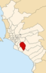
Villa María del Triunfo
Encyclopedia
Villa María del Triunfo is a district
of the Lima Province
in Peru
. It located in the Cono Sur area of the city of Lima
.
Officially established as a district on December 28, 1961, the current mayor
(alcaldesa) of Villa María del Triunfo is Silvia Barrera . The district's postal code
is 35.
of 70.57 km². Its administrative center is located 158 meters above sea level
.
, the district has 329,057 inhabitants and a population density of 4662.8 persons/km². In 1999, there were 71,889 households in the district.
According to Propoli (http://www.propoli.org/quehacemos.htm) :
The principal economic activities in the region are: "Sector maderero, cevicheros, calzado-maquicentros, confecciones, metal mecánica, circuito turístico."
The rate of undernourishment is: 14.76%
The proportion of the population without water is: 34.05%
The proportion of the population without electricity is: 22.9%
Districts of Peru
The districts of Peru are the third-level country subdivisions of Peru. They are subdivisions of the provinces, which in turn are subdivisions of the larger regions or departments...
of the Lima Province
Lima Province
Lima Province is located in the central coast of Peru and is the only province in the country not belonging to any of the twenty-five regions. Its capital is Lima, which is also the nation's capital....
in Peru
Peru
Peru , officially the Republic of Peru , is a country in western South America. It is bordered on the north by Ecuador and Colombia, on the east by Brazil, on the southeast by Bolivia, on the south by Chile, and on the west by the Pacific Ocean....
. It located in the Cono Sur area of the city of Lima
Lima
Lima is the capital and the largest city of Peru. It is located in the valleys of the Chillón, Rímac and Lurín rivers, in the central part of the country, on a desert coast overlooking the Pacific Ocean. Together with the seaport of Callao, it forms a contiguous urban area known as the Lima...
.
Officially established as a district on December 28, 1961, the current mayor
Mayor
In many countries, a Mayor is the highest ranking officer in the municipal government of a town or a large urban city....
(alcaldesa) of Villa María del Triunfo is Silvia Barrera . The district's postal code
Postal code
A postal code is a series of letters and/or digits appended to a postal address for the purpose of sorting mail. Once postal codes were introduced, other applications became possible.In February 2005, 117 of the 190 member countries of the Universal Postal Union had postal code systems...
is 35.
Geography
The district has a total land areaArea
Area is a quantity that expresses the extent of a two-dimensional surface or shape in the plane. Area can be understood as the amount of material with a given thickness that would be necessary to fashion a model of the shape, or the amount of paint necessary to cover the surface with a single coat...
of 70.57 km². Its administrative center is located 158 meters above sea level
Sea level
Mean sea level is a measure of the average height of the ocean's surface ; used as a standard in reckoning land elevation...
.
Boundaries
- North: La MolinaLa MolinaLa Molina is a district of the Lima Province in Peru, and one of the upscale districts that comprise the city of Lima.Officially established as a district on February 6, 1962, the current mayor of La Molina is Juan Carlos Zurek. The district's postal code is 12.-Geography:The district has a total...
- East: PachacamacPachacamac DistrictThe Pachacamac District is one of 43 districts of the Lima Province in Peru. The capital of the district is the village of Pachacamac. Its main asset is the archaeological Inca site Pachacamac.-History:...
- South: Villa El SalvadorVilla El SalvadorVilla El Salvador is an urban, largely residential district on the outskirts of Lima, Peru. It borders the district of Chorrillos on the east; the Pacific Ocean on the southwest; Lurín on the southeast; Villa María del Triunfo on the east and San Juan de Miraflores on the north.- History :It began...
and LurínLurín DistrictThe Peruvian district of Lurín is one of the 43 that make up the Lima Province.-Boundaries:It borders on the north with the districts of Pachacamac, Villa María del Triunfo, and Villa el Salvador, to the east also with the Pachacamac District, to the south with Punta Hermosa, and to the west with... - West: San Juan de MirafloresSan Juan de MirafloresSan Juan de Miraflores is a district of the Lima Province in Peru. It is located in the Cono Sur area of the city of Lima.Officially established as a district on January 12, 1965, the current mayor of San Juan de Miraflores is Edilberto Quispe Rodriguez...
Demographics
According to a 2002 estimate by the INEIInstituto Nacional de Estadística e Informática
The Instituto Nacional de Estadística e Informática is a semi-autonomous Peruvian government agency which coordinates, compiles, and evaluates statistical information for the country...
, the district has 329,057 inhabitants and a population density of 4662.8 persons/km². In 1999, there were 71,889 households in the district.
According to Propoli (http://www.propoli.org/quehacemos.htm) :
The principal economic activities in the region are: "Sector maderero, cevicheros, calzado-maquicentros, confecciones, metal mecánica, circuito turístico."
The rate of undernourishment is: 14.76%
The proportion of the population without water is: 34.05%
The proportion of the population without electricity is: 22.9%