

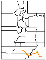
San Juan Expedition
Encyclopedia
Mormon
The term Mormon most commonly denotes an adherent, practitioner, follower, or constituent of Mormonism, which is the largest branch of the Latter Day Saint movement in restorationist Christianity...
settlers intent on establishing a colony in what is now southeastern Utah
Utah
Utah is a state in the Western United States. It was the 45th state to join the Union, on January 4, 1896. Approximately 80% of Utah's 2,763,885 people live along the Wasatch Front, centering on Salt Lake City. This leaves vast expanses of the state nearly uninhabited, making the population the...
, in the western United States
United States
The United States of America is a federal constitutional republic comprising fifty states and a federal district...
. Their difficult passage through the deep canyons of the Colorado River
Colorado River
The Colorado River , is a river in the Southwestern United States and northwestern Mexico, approximately long, draining a part of the arid regions on the western slope of the Rocky Mountains. The watershed of the Colorado River covers in parts of seven U.S. states and two Mexican states...
represents the ingenuity and determination needed during the country's era of western exploration and settlement.
Background
After arriving in the Salt Lake ValleySalt Lake Valley
Salt Lake Valley is a valley in Salt Lake County in the north-central portion of the U.S. state of Utah. It contains Salt Lake City and many of its suburbs, notably West Valley City, Murray, Sandy, and West Jordan; its total population is 1,029,655 as of 2010...
in 1847, the Mormons had expanded their settlements throughout central and southeastern Utah. In 1878 the leaders of their church decided to establish a new colony in a remote area to the east of the Colorado River, in what is now the Four Corners Area. They scouted possible sites, deciding on the fertile valley of Montezuma Creek
Montezuma Creek (San Juan River)
Montezuma Creek is a tributary of the San Juan River. The river is approximately long and is a seasonal river, becoming dry for several months of the year.-Location:...
just north of the San Juan River. Routes to the new settlement were also scouted, including the established path of the Old Spanish Trail
Old Spanish Trail (trade route)
The Old Spanish Trail is a historical trade route which connected the northern New Mexico settlements near or in Santa Fe, New Mexico with that of Los Angeles, California and southern California. Approximately long, it ran through areas of high mountains, arid deserts, and deep canyons. It is...
and a long route around the southern rim of the Grand Canyon
Grand Canyon
The Grand Canyon is a steep-sided canyon carved by the Colorado River in the United States in the state of Arizona. It is largely contained within the Grand Canyon National Park, the 15th national park in the United States...
.
The expedition decided, however, to use a more direct (but largely unknown) route that would be hundreds of miles shorter. They would travel through the relatively benign terrain near the Escalante River
Escalante River
right|Location of the Escalante River within UtahThe Escalante River is a tributary of the Colorado River. It is formed by the confluence of North and Birch Creeks near the town of Escalante in south-central Utah, and from there flows southeast for approximately before joining Lake Powell...
, find a way to cross the Colorado River
Colorado River
The Colorado River , is a river in the Southwestern United States and northwestern Mexico, approximately long, draining a part of the arid regions on the western slope of the Rocky Mountains. The watershed of the Colorado River covers in parts of seven U.S. states and two Mexican states...
, and then negotiate the mesas and canyons on the other side.

The expedition
In the fall of 1879 volunteers for the expedition assembled their wagons, supplies, and livestock at a spring at the head of Fortymile GulchFortymile Gulch
right|Location of Fortymile and Willow Gulches within UtahFortymile Gulch and Willow Gulch are tributaries of the Escalante River, located in Kane County in southern Utah, in the western United States...
, just south of the deep canyons
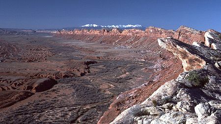
Canyons of the Escalante
The Canyons of the Escalante is a collective name for the erosional landforms created by the Escalante River and its tributaries, the Escalante River Basin. Located in southern Utah in the western United States, these sandstone features include high vertical canyon walls, water pockets, narrow...
of the Escalante River Basin, and just north of the cliffs of the Kaiparowits Plateau
Kaiparowits Plateau
right|Location of the Kaiparowits Plateau within UtahThe Kaiparowits Plateau is a large, elevated landform located in southern Utah, in the southwestern United States. Along with the Grand Staircase and the Canyons of the Escalante, it makes up a significant portion of the Grand...
. A smaller group went ahead to find and prepare a crossing for Glen Canyon
Glen Canyon
Glen Canyon is a canyon that is located in southeastern and south central Utah and northwestern Arizona within the Vermilion Cliffs area. It was carved by the Colorado River....
and the Colorado River
Colorado River
The Colorado River , is a river in the Southwestern United States and northwestern Mexico, approximately long, draining a part of the arid regions on the western slope of the Rocky Mountains. The watershed of the Colorado River covers in parts of seven U.S. states and two Mexican states...
. At Cottonwood Canyon they saw a tempting route up from the far side of the river and, on the near side, a narrow crevice that might allow a descent into the canyon. Naming it Hole-in-the-Rock
Hole in the Rock (road)
Hole in the Rock is a narrow and steep crevice in the western rim of Glen Canyon, in southern Utah in the western United States. Together with another canyon on the eastern side of the Colorado River, it provided a route through what would otherwise be a large area of impassible terrain.In the...
, they proceeded to spend several months widening it for the passage of wagons, and building anchor points and tracks to assist with the descent.
The main expedition proceeded on what is now the Hole in the Rock Trail and, on January 26, 1880, began their descent to the river. People and livestock climbed down the crevice, and wagons were lowered by a system of ropes. A wooden trackway near the bottom provided access around a gulch filled with boulders. A wooden ferry was built at the river by Charles Hall, and was used to cross the river. Despite the perilous nature of this route, all of the expedition made the descent (a third of it on the first day).
A member of the expedition, Kumen Jones, wrote:
After about six weeks work and waiting for powder, etc., a start was made to move the wagons down the hole. I had a well broken team and hitched it on to B. Perkins wagon and drove it down through the hole. Long ropes were provided and about 20 men and boys held on to the wagons to make sure that there would be no accidents, through [brakes] giving way, or horses cutting up after their long lay off, but all went smooth and safe, and by the 28th, most of the wagons were across the river and work had commenced again on the Cottonwood CanyonCottonwood Canyon (Utah)Cottonwood Canyon in the U.S. state of Utah is a water-carved canyon that has eroded along weak locations in the Earth's crust at the joins between major geological regions...
another very rough proposition.
However, the expedition found much greater difficulty on the east side of the river. A maze of canyons, mesas, and cliffs extending from the Colorado and San Juan Rivers makes this area almost impassible. The deep canyons of Grand Gulch had to be bypassed completely, forcing the expedition far to the north. Finally, they arrived at Salvation Knoll, atop Cedar Mesa near present-day Natural Bridges National Monument
Natural Bridges National Monument
Natural Bridges National Monument is a U.S. National Monument located about north west of the Four Corners boundary of southeast Utah, in the western United States, at the junction of White Canyon and Armstrong Canyon, part of the Colorado River drainage...
. They could now see an easier slope that would lead them down into Comb Wash, through which they could travel back south to the San Juan River. After traveling further east, and just twenty miles from their original goal, the exhausted expedition halted and founded the community of Bluff
Bluff, Utah
Bluff is a census-designated place in San Juan County, Utah, United States. The population was 320 at the 2000 census.-Geography:Bluff is located at , in the scenic and very sparsely populated southeastern Utah canyonlands of the Colorado Plateau.According to the United States Census Bureau, the...
.
A journey planned for six weeks had instead taken six months. No lives were lost, and two children were born. The expedition's route was used as a supply road for just a year, before Charles Hall moved his ferry to an easier crossing
Halls Crossing, Utah
Halls Crossing is a census-designated place in San Juan County, Utah, United States. The population was six at the 2010 Census. State Route 276 crosses the Colorado River at Halls Crossing using the Charles Hall Ferry.-Geography:...
further north.
Further reading
- "Hole-In-The-Rock", an informational brochure distributed by the National Park Service
- "Incredible Passage Through the Hole-In-The-Rock", by Lee Reay (1980) ISBN 0-934826-06-4
- "The Hole-in-the-Rock Trail a Century Later", by Allan Kent Powell (1983), ISBN 0-879058-85-4
- "Hole-in-the-Rock: An Epic in the Colonization of the Great American West", by David E. Miller (1966), ISBN 0-963992-41-4
- "Saga of San Juan", by Cornelia Adams Perkins, Marian Gardner Nielson, and Lenora Butt Jones (1968)
- "A Guide to Southern Utah's Hole-in-the-Rock Trail", by Stewart Aitchison (2005), ISBN 0-87480-821-9
External links
- The Hole-in-the-Rock Trail
- Hole-in-the Rock, Glen Canyon National Recreation Area, U.S. National Park ServiceNational Park ServiceThe National Park Service is the U.S. federal agency that manages all national parks, many national monuments, and other conservation and historical properties with various title designations...