

San Andreas, California
Encyclopedia
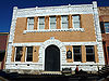
San Andreas is an unincorporated
census-designated place
and the county seat
of Calaveras County, California
. The population was 2,783 at the 2010 census, up from 2,615 at the 2000 census. Like most towns in the region, it was originally founded during the California Gold Rush
. The town is located on State Route 49
and is registered as California Historical Landmark
#252.
 Settled by Mexican
gold miners in 1848 and named after the Catholic
parish St. Andrew, the town has been a noted mining camp since early days. The gold
from the initially discovered placers
gave out after a few years, but the discovery of gold in an underground river channel in 1853 revitalized the camp and it soon became a town. Mining of the channels was lucrative enough for the town to completely rebuild after fires in 1858 and 1863. The gold discovered here contributed greatly to the success of the Union
during the Civil War
. In 1866, San Andreas became the seat
of Calaveras County. It was said to be a rendezvous location for Joaquin Murietta. Notorious highwayman
Black Bart
was tried here and sent to prison.
The post office was established in 1854.
, the CDP has a total area of 8.4 square miles (21.8 km²), of which, 99.81% is land and 0.19% is water.
was 331.5 people per square mile (128.0/km²). The racial makeup of San Andreas was 2,453 (88.1%) White, 23 (0.8%) African American, 48 (1.7%) Native American, 28 (1.0%) Asian, 1 (0.0%) Pacific Islander, 83 (3.0%) from other races
, and 147 (5.3%) from two or more races. Hispanic or Latino of any race were 255 persons (9.2%).
The Census reported that 2,595 people (93.2% of the population) lived in households, 21 (0.8%) lived in non-institutionalized group quarters, and 167 (6.0%) were institutionalized.
There were 1,146 households, out of which 314 (27.4%) had children under the age of 18 living in them, 449 (39.2%) were opposite-sex married couples
living together, 156 (13.6%) had a female householder with no husband present, 66 (5.8%) had a male householder with no wife present. There were 91 (7.9%) unmarried opposite-sex partnerships
, and 13 (1.1%) same-sex married couples or partnerships. 396 households (34.6%) were made up of individuals and 190 (16.6%) had someone living alone who was 65 years of age or older. The average household size was 2.26. There were 671 families
(58.6% of all households); the average family size was 2.84.
The population was spread out with 585 people (21.0%) under the age of 18, 197 people (7.1%) aged 18 to 24, 589 people (21.2%) aged 25 to 44, 777 people (27.9%) aged 45 to 64, and 635 people (22.8%) who were 65 years of age or older. The median age was 45.7 years. For every 100 females there were 88.6 males. For every 100 females age 18 and over, there were 85.0 males.
There were 1,311 housing units at an average density of 156.2 per square mile (60.3/km²), of which 632 (55.1%) were owner-occupied, and 514 (44.9%) were occupied by renters. The homeowner vacancy rate was 1.9%; the rental vacancy rate was 13.3%. 1,404 people (50.4% of the population) lived in owner-occupied housing units and 1,191 people (42.8%) lived in rental housing units.
 As of the census
of 2000, there were 2,615 people, 1,097 households, and 652 families residing in the CDP. The population density
was 299.4 people per square mile (115.5/km²). There were 1,167 housing units at an average density of 133.6 per square mile (51.6/km²). The racial makeup of the CDP was 92.1% White
, 0.1% Black
or African American
, 1.5% Native American
, 0.7% Asian
, 2.0% from other races
, and 3.6% from two or more races. 6.4% of the population were Hispanic
or Latino
of any race.
There were 1,097 households out of which 28.0% had children under the age of 18 living with them, 41.9% were married couples
living together, 13.8% had a female householder with no husband present, and 40.5% were non-families. 34.2% of all households were made up of individuals and 18.4% had someone living alone who was 65 years of age or older. The average household size was 2.24 and the average family size was 2.85.
In the CDP the population was spread out with 24.2% under the age of 18, 7.6% from 18 to 24, 21.6% from 25 to 44, 22.6% from 45 to 64, and 23.9% who were 65 years of age or older. The median age was 43 years. For every 100 females there were 89.8 males. For every 100 females age 18 and over, there were 81.9 males.
The median income for a household in the CDP was $32,500, and the median income for a family was $37,969. Males had a median income of $39,583 versus $24,500 for females. The per capita income
for the CDP was $16,813. About 14.4% of families and 14.8% of the population were below the poverty line, including 19.5% of those under age 18 and 8.9% of those age 65 or over.
San Andreas is located in the 1st Senate
District, represented by Republican
Dave Cox
, and in the 25th Assembly
District, represented by Republican Kristin Olsen
. Federally, San Andreas is located in California's 3rd congressional district
, which has a Cook PVI
of R+7 and is represented by Republican Dan Lungren
.
Unincorporated area
In law, an unincorporated area is a region of land that is not a part of any municipality.To "incorporate" in this context means to form a municipal corporation, a city, town, or village with its own government. An unincorporated community is usually not subject to or taxed by a municipal government...
census-designated place
Census-designated place
A census-designated place is a concentration of population identified by the United States Census Bureau for statistical purposes. CDPs are delineated for each decennial census as the statistical counterparts of incorporated places such as cities, towns and villages...
and the county seat
County seat
A county seat is an administrative center, or seat of government, for a county or civil parish. The term is primarily used in the United States....
of Calaveras County, California
Calaveras County, California
Calaveras County is a county located in the Gold Country of the U.S. state of California. Calaveras is the Spanish word for skulls; the county was reportedly named for the remains of Native Americans discovered by the Spanish explorer Captain Gabriel Moraga. As of the 2010 census, the county had a...
. The population was 2,783 at the 2010 census, up from 2,615 at the 2000 census. Like most towns in the region, it was originally founded during the California Gold Rush
California Gold Rush
The California Gold Rush began on January 24, 1848, when gold was found by James W. Marshall at Sutter's Mill in Coloma, California. The first to hear confirmed information of the gold rush were the people in Oregon, the Sandwich Islands , and Latin America, who were the first to start flocking to...
. The town is located on State Route 49
California State Route 49
State Route 49 is a north–south state highway in the U.S. state of California that passes through many historic mining communities of the 1849 California gold rush. Highway 49 is numbered after the "49ers", the waves of immigrants who swept into the area looking for gold, and a portion of it...
and is registered as California Historical Landmark
California Historical Landmark
California Historical Landmarks are buildings, structures, sites, or places in the state of California that have been determined to have statewide historical significance by meeting at least one of the criteria listed below:...
#252.
History
Mexico
The United Mexican States , commonly known as Mexico , is a federal constitutional republic in North America. It is bordered on the north by the United States; on the south and west by the Pacific Ocean; on the southeast by Guatemala, Belize, and the Caribbean Sea; and on the east by the Gulf of...
gold miners in 1848 and named after the Catholic
Catholic
The word catholic comes from the Greek phrase , meaning "on the whole," "according to the whole" or "in general", and is a combination of the Greek words meaning "about" and meaning "whole"...
parish St. Andrew, the town has been a noted mining camp since early days. The gold
Gold
Gold is a chemical element with the symbol Au and an atomic number of 79. Gold is a dense, soft, shiny, malleable and ductile metal. Pure gold has a bright yellow color and luster traditionally considered attractive, which it maintains without oxidizing in air or water. Chemically, gold is a...
from the initially discovered placers
Placer mining
Placer mining is the mining of alluvial deposits for minerals. This may be done by open-pit or by various surface excavating equipment or tunneling equipment....
gave out after a few years, but the discovery of gold in an underground river channel in 1853 revitalized the camp and it soon became a town. Mining of the channels was lucrative enough for the town to completely rebuild after fires in 1858 and 1863. The gold discovered here contributed greatly to the success of the Union
Union (American Civil War)
During the American Civil War, the Union was a name used to refer to the federal government of the United States, which was supported by the twenty free states and five border slave states. It was opposed by 11 southern slave states that had declared a secession to join together to form the...
during the Civil War
American Civil War
The American Civil War was a civil war fought in the United States of America. In response to the election of Abraham Lincoln as President of the United States, 11 southern slave states declared their secession from the United States and formed the Confederate States of America ; the other 25...
. In 1866, San Andreas became the seat
County seat
A county seat is an administrative center, or seat of government, for a county or civil parish. The term is primarily used in the United States....
of Calaveras County. It was said to be a rendezvous location for Joaquin Murietta. Notorious highwayman
Highwayman
A highwayman was a thief and brigand who preyed on travellers. This type of outlaw, usually, travelled and robbed by horse, as compared to a footpad who traveled and robbed on foot. Mounted robbers were widely considered to be socially superior to footpads...
Black Bart
Charles Bolles
Charles Earl Bowles , better known as Black Bart, was an English-born American Old West outlaw noted for his poetic messages left after two of his robberies. Also known as Charles Bolton, C.E...
was tried here and sent to prison.
The post office was established in 1854.
Geography
According to the United States Census BureauUnited States Census Bureau
The United States Census Bureau is the government agency that is responsible for the United States Census. It also gathers other national demographic and economic data...
, the CDP has a total area of 8.4 square miles (21.8 km²), of which, 99.81% is land and 0.19% is water.
2010
The 2010 United States Census reported that San Andreas had a population of 2,783. The population densityPopulation density
Population density is a measurement of population per unit area or unit volume. It is frequently applied to living organisms, and particularly to humans...
was 331.5 people per square mile (128.0/km²). The racial makeup of San Andreas was 2,453 (88.1%) White, 23 (0.8%) African American, 48 (1.7%) Native American, 28 (1.0%) Asian, 1 (0.0%) Pacific Islander, 83 (3.0%) from other races
Race (United States Census)
Race and ethnicity in the United States Census, as defined by the Federal Office of Management and Budget and the United States Census Bureau, are self-identification data items in which residents choose the race or races with which they most closely identify, and indicate whether or not they are...
, and 147 (5.3%) from two or more races. Hispanic or Latino of any race were 255 persons (9.2%).
The Census reported that 2,595 people (93.2% of the population) lived in households, 21 (0.8%) lived in non-institutionalized group quarters, and 167 (6.0%) were institutionalized.
There were 1,146 households, out of which 314 (27.4%) had children under the age of 18 living in them, 449 (39.2%) were opposite-sex married couples
Marriage
Marriage is a social union or legal contract between people that creates kinship. It is an institution in which interpersonal relationships, usually intimate and sexual, are acknowledged in a variety of ways, depending on the culture or subculture in which it is found...
living together, 156 (13.6%) had a female householder with no husband present, 66 (5.8%) had a male householder with no wife present. There were 91 (7.9%) unmarried opposite-sex partnerships
POSSLQ
POSSLQ is an abbreviation for "Persons of Opposite Sex Sharing Living Quarters," a term coined in the late 1970s by the United States Census Bureau as part of an effort to more accurately gauge the prevalence of cohabitation in American households....
, and 13 (1.1%) same-sex married couples or partnerships. 396 households (34.6%) were made up of individuals and 190 (16.6%) had someone living alone who was 65 years of age or older. The average household size was 2.26. There were 671 families
Family (U.S. Census)
A family or family household is defined by the United States Census Bureau for statistical purposes as "a householder and one or more other people related to the householder by birth, marriage, or adoption. They do not include same-sex married couples even if the marriage was performed in a state...
(58.6% of all households); the average family size was 2.84.
The population was spread out with 585 people (21.0%) under the age of 18, 197 people (7.1%) aged 18 to 24, 589 people (21.2%) aged 25 to 44, 777 people (27.9%) aged 45 to 64, and 635 people (22.8%) who were 65 years of age or older. The median age was 45.7 years. For every 100 females there were 88.6 males. For every 100 females age 18 and over, there were 85.0 males.
There were 1,311 housing units at an average density of 156.2 per square mile (60.3/km²), of which 632 (55.1%) were owner-occupied, and 514 (44.9%) were occupied by renters. The homeowner vacancy rate was 1.9%; the rental vacancy rate was 13.3%. 1,404 people (50.4% of the population) lived in owner-occupied housing units and 1,191 people (42.8%) lived in rental housing units.
2000
Census
A census is the procedure of systematically acquiring and recording information about the members of a given population. It is a regularly occurring and official count of a particular population. The term is used mostly in connection with national population and housing censuses; other common...
of 2000, there were 2,615 people, 1,097 households, and 652 families residing in the CDP. The population density
Population density
Population density is a measurement of population per unit area or unit volume. It is frequently applied to living organisms, and particularly to humans...
was 299.4 people per square mile (115.5/km²). There were 1,167 housing units at an average density of 133.6 per square mile (51.6/km²). The racial makeup of the CDP was 92.1% White
Race (United States Census)
Race and ethnicity in the United States Census, as defined by the Federal Office of Management and Budget and the United States Census Bureau, are self-identification data items in which residents choose the race or races with which they most closely identify, and indicate whether or not they are...
, 0.1% Black
Race (United States Census)
Race and ethnicity in the United States Census, as defined by the Federal Office of Management and Budget and the United States Census Bureau, are self-identification data items in which residents choose the race or races with which they most closely identify, and indicate whether or not they are...
or African American
Race (United States Census)
Race and ethnicity in the United States Census, as defined by the Federal Office of Management and Budget and the United States Census Bureau, are self-identification data items in which residents choose the race or races with which they most closely identify, and indicate whether or not they are...
, 1.5% Native American
Race (United States Census)
Race and ethnicity in the United States Census, as defined by the Federal Office of Management and Budget and the United States Census Bureau, are self-identification data items in which residents choose the race or races with which they most closely identify, and indicate whether or not they are...
, 0.7% Asian
Race (United States Census)
Race and ethnicity in the United States Census, as defined by the Federal Office of Management and Budget and the United States Census Bureau, are self-identification data items in which residents choose the race or races with which they most closely identify, and indicate whether or not they are...
, 2.0% from other races
Race (United States Census)
Race and ethnicity in the United States Census, as defined by the Federal Office of Management and Budget and the United States Census Bureau, are self-identification data items in which residents choose the race or races with which they most closely identify, and indicate whether or not they are...
, and 3.6% from two or more races. 6.4% of the population were Hispanic
Race (United States Census)
Race and ethnicity in the United States Census, as defined by the Federal Office of Management and Budget and the United States Census Bureau, are self-identification data items in which residents choose the race or races with which they most closely identify, and indicate whether or not they are...
or Latino
Race (United States Census)
Race and ethnicity in the United States Census, as defined by the Federal Office of Management and Budget and the United States Census Bureau, are self-identification data items in which residents choose the race or races with which they most closely identify, and indicate whether or not they are...
of any race.
There were 1,097 households out of which 28.0% had children under the age of 18 living with them, 41.9% were married couples
Marriage
Marriage is a social union or legal contract between people that creates kinship. It is an institution in which interpersonal relationships, usually intimate and sexual, are acknowledged in a variety of ways, depending on the culture or subculture in which it is found...
living together, 13.8% had a female householder with no husband present, and 40.5% were non-families. 34.2% of all households were made up of individuals and 18.4% had someone living alone who was 65 years of age or older. The average household size was 2.24 and the average family size was 2.85.
In the CDP the population was spread out with 24.2% under the age of 18, 7.6% from 18 to 24, 21.6% from 25 to 44, 22.6% from 45 to 64, and 23.9% who were 65 years of age or older. The median age was 43 years. For every 100 females there were 89.8 males. For every 100 females age 18 and over, there were 81.9 males.
The median income for a household in the CDP was $32,500, and the median income for a family was $37,969. Males had a median income of $39,583 versus $24,500 for females. The per capita income
Per capita income
Per capita income or income per person is a measure of mean income within an economic aggregate, such as a country or city. It is calculated by taking a measure of all sources of income in the aggregate and dividing it by the total population...
for the CDP was $16,813. About 14.4% of families and 14.8% of the population were below the poverty line, including 19.5% of those under age 18 and 8.9% of those age 65 or over.
Politics
In the state legislatureCalifornia State Legislature
The California State Legislature is the state legislature of the U.S. state of California. It is a bicameral body consisting of the lower house, the California State Assembly, with 80 members, and the upper house, the California State Senate, with 40 members...
San Andreas is located in the 1st Senate
California State Senate
The California State Senate is the upper house of the California State Legislature. There are 40 state senators. The state legislature meets in the California State Capitol in Sacramento. The Lieutenant Governor is the ex officio President of the Senate and may break a tied vote...
District, represented by Republican
Republican Party (United States)
The Republican Party is one of the two major contemporary political parties in the United States, along with the Democratic Party. Founded by anti-slavery expansion activists in 1854, it is often called the GOP . The party's platform generally reflects American conservatism in the U.S...
Dave Cox
Dave Cox
David E. Cox was an American politician from Holdenville, Oklahoma. A Republican, he served as a California State Senator, representing the 1st district from December 2004 until his death in July 2010, and also served as an California State Assemblyman for the six years immediately before his...
, and in the 25th Assembly
California State Assembly
The California State Assembly is the lower house of the California State Legislature. There are 80 members in the Assembly, representing an approximately equal number of constituents, with each district having a population of at least 420,000...
District, represented by Republican Kristin Olsen
Kristin Olsen
Kristin Olsen is an American politician currently serving in the California State Assembly. She is a Republican representing the 25th district, encompassing Calaveras, Mariposa, Mono, and Tuolumne counties, and parts of Madera and Stanislaus counties...
. Federally, San Andreas is located in California's 3rd congressional district
California's 3rd congressional district
California's 3rd congressional district is a congressional district located in the U.S. state of California. It covers most of Sacramento County and part of Solano County, as well as all of Alpine, Amador and Calaveras counties...
, which has a Cook PVI
Cook Partisan Voting Index
The Cook Partisan Voting Index , sometimes referred to as simply the Partisan Voting Index , is a measurement of how strongly an American congressional district or state leans toward one political party compared to the nation as a whole...
of R+7 and is represented by Republican Dan Lungren
Dan Lungren
Daniel Edward "Dan" Lungren is the U.S. Representative for , serving since 2005. The district covers most of Sacramento County and part of Solano County, as well as all of Alpine, Amador and Calaveras counties...
.