
Salmon Creek, California
Encyclopedia
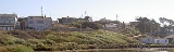
Salmon Creek is an unincorporated
settlement and census-designated place
(CDP) in Sonoma County
, California
, U.S.
It is located on the Pacific coast
about 90 minutes drive north of San Francisco, between the towns of Jenner
and Bodega Bay, California
. The population was 86 at the 2010 census.
The settlement is bounded to the north by Salmon Creek
, to the east by State Route 1
and to the west and south by Sonoma Coast State Beach
.
village of Pulya-lakum was formerly located near the mouth of Salmon Creek. In 1812, the Russian-American Company
established Fort Ross about 12 miles (19 km) northwest of present-day Salmon Creek, bringing the area into the Russian Empire
's sphere of influence.
, the CDP covers an area of 1.1 square miles (2.9 km²), all of it land.
was 77.2 people per square mile (29.8/km²). The racial makeup of Salmon Creek was 100.0% White (98.8% non-Hispanic). 1.2% of the population was Hispanic or Latino of any race.
The Census reported that 100% of the population lived in households.
There were 45 households, out of which 2 (4.4%) had children under the age of 18 living in them, 22 (48.9%) were opposite-sex married couples
living together, 2 (4.4%) had a female householder with no husband present, 1 (2.2%) had a male householder with no wife present. There were 1 (2.2%) unmarried opposite-sex partnerships
, and 0 (0%) same-sex married couples or partnerships. 18 households (40.0%) were made up of individuals and 5 (11.1%) had someone living alone who was 65 years of age or older. The average household size was 1.91. There were 25 families
(55.6% of all households); the average family size was 2.52.
The population was spread out with 5 people (5.8%) under the age of 18, 3 people (3.5%) aged 18 to 24, 13 people (15.1%) aged 25 to 44, 42 people (48.8%) aged 45 to 64, and 23 people (26.7%) who were 65 years of age or older. The median age was 59.0 years. For every 100 females there were 104.8 males. For every 100 females age 18 and over, there were 102.5 males.
There were 116 housing units at an average density of 104.1 per square mile (40.2/km²), of which 75.6% were owner-occupied and 24.4% were occupied by renters. The homeowner vacancy rate was 10.3%; the rental vacancy rate was 0%. 83.7% of the population lived in owner-occupied housing units and 16.3% lived in rental housing units.
The population of the ZIP code was 1,769. However, that ZIP code also includes the town of Bodega Bay, California
and rural areas. Salmon Creek was only designated a CDP for the 2010 census.
Unincorporated area
In law, an unincorporated area is a region of land that is not a part of any municipality.To "incorporate" in this context means to form a municipal corporation, a city, town, or village with its own government. An unincorporated community is usually not subject to or taxed by a municipal government...
settlement and census-designated place
Census-designated place
A census-designated place is a concentration of population identified by the United States Census Bureau for statistical purposes. CDPs are delineated for each decennial census as the statistical counterparts of incorporated places such as cities, towns and villages...
(CDP) in Sonoma County
Sonoma County, California
Sonoma County, located on the northern coast of the U.S. state of California, is the largest and northernmost of the nine San Francisco Bay Area counties. Its population at the 2010 census was 483,878. Its largest city and county seat is Santa Rosa....
, California
California
California is a state located on the West Coast of the United States. It is by far the most populous U.S. state, and the third-largest by land area...
, U.S.
United States
The United States of America is a federal constitutional republic comprising fifty states and a federal district...
It is located on the Pacific coast
Pacific Ocean
The Pacific Ocean is the largest of the Earth's oceanic divisions. It extends from the Arctic in the north to the Southern Ocean in the south, bounded by Asia and Australia in the west, and the Americas in the east.At 165.2 million square kilometres in area, this largest division of the World...
about 90 minutes drive north of San Francisco, between the towns of Jenner
Jenner, California
Jenner is a small coastal town and census-designated place with a population of about 136 in Sonoma County, California, U.S. It is located on the Pacific coast near the mouth of the Russian River. State Route 1 runs through the town and State Route 116 runs nearby, along the Russian River...
and Bodega Bay, California
Bodega Bay, California
Bodega Bay is a town and census-designated place in Sonoma County, California, United States. The population was 1,077 at the 2010 census. The town is on the eastern side of Bodega Harbor, an inlet of Bodega Bay on the Pacific coast....
. The population was 86 at the 2010 census.
The settlement is bounded to the north by Salmon Creek
Salmon Creek (Sonoma County, California)
Salmon Creek is an stream in western Sonoma County, California that springs from coastal hills west of the town of Occidental and empties into the Pacific Ocean north of Bodega Head.-Course:...
, to the east by State Route 1
California State Route 1
State Route 1 , more often called Highway 1, is a state highway that runs along much of the Pacific coast of the U.S. state of California. It is famous for running along some of the most beautiful coastlines in the world, leading to its designation as an All-American Road.Highway 1 does not run...
and to the west and south by Sonoma Coast State Beach
Sonoma Coast State Beach
Sonoma Coast State Beach is a State of California property in Sonoma County consisting of public access use on lands adjoining the Pacific Ocean. This extent of beach runs from a coastal point about north of Jenner and continues for approximately to the south to terminate at Bodega Head...
.
History
The Coast MiwokCoast Miwok
The Coast Miwok were the second largest group of Miwok Native American people. The Coast Miwok inhabited the general area of modern Marin County and southern Sonoma County in Northern California, from the Golden Gate north to Duncans Point and eastward to Sonoma Creek...
village of Pulya-lakum was formerly located near the mouth of Salmon Creek. In 1812, the Russian-American Company
Russian-American Company
The Russian-American Company was a state-sponsored chartered company formed largely on the basis of the so-called Shelekhov-Golikov Company of Grigory Shelekhov and Ivan Larionovich Golikov The Russian-American Company (officially: Under His Imperial Majesty's Highest Protection (patronage)...
established Fort Ross about 12 miles (19 km) northwest of present-day Salmon Creek, bringing the area into the Russian Empire
Russian Empire
The Russian Empire was a state that existed from 1721 until the Russian Revolution of 1917. It was the successor to the Tsardom of Russia and the predecessor of the Soviet Union...
's sphere of influence.
Geography
According to the United States Census BureauUnited States Census Bureau
The United States Census Bureau is the government agency that is responsible for the United States Census. It also gathers other national demographic and economic data...
, the CDP covers an area of 1.1 square miles (2.9 km²), all of it land.
2010
The 2010 United States Census reported that Salmon Creek had a population of 86. The population densityPopulation density
Population density is a measurement of population per unit area or unit volume. It is frequently applied to living organisms, and particularly to humans...
was 77.2 people per square mile (29.8/km²). The racial makeup of Salmon Creek was 100.0% White (98.8% non-Hispanic). 1.2% of the population was Hispanic or Latino of any race.
The Census reported that 100% of the population lived in households.
There were 45 households, out of which 2 (4.4%) had children under the age of 18 living in them, 22 (48.9%) were opposite-sex married couples
Marriage
Marriage is a social union or legal contract between people that creates kinship. It is an institution in which interpersonal relationships, usually intimate and sexual, are acknowledged in a variety of ways, depending on the culture or subculture in which it is found...
living together, 2 (4.4%) had a female householder with no husband present, 1 (2.2%) had a male householder with no wife present. There were 1 (2.2%) unmarried opposite-sex partnerships
POSSLQ
POSSLQ is an abbreviation for "Persons of Opposite Sex Sharing Living Quarters," a term coined in the late 1970s by the United States Census Bureau as part of an effort to more accurately gauge the prevalence of cohabitation in American households....
, and 0 (0%) same-sex married couples or partnerships. 18 households (40.0%) were made up of individuals and 5 (11.1%) had someone living alone who was 65 years of age or older. The average household size was 1.91. There were 25 families
Family (U.S. Census)
A family or family household is defined by the United States Census Bureau for statistical purposes as "a householder and one or more other people related to the householder by birth, marriage, or adoption. They do not include same-sex married couples even if the marriage was performed in a state...
(55.6% of all households); the average family size was 2.52.
The population was spread out with 5 people (5.8%) under the age of 18, 3 people (3.5%) aged 18 to 24, 13 people (15.1%) aged 25 to 44, 42 people (48.8%) aged 45 to 64, and 23 people (26.7%) who were 65 years of age or older. The median age was 59.0 years. For every 100 females there were 104.8 males. For every 100 females age 18 and over, there were 102.5 males.
There were 116 housing units at an average density of 104.1 per square mile (40.2/km²), of which 75.6% were owner-occupied and 24.4% were occupied by renters. The homeowner vacancy rate was 10.3%; the rental vacancy rate was 0%. 83.7% of the population lived in owner-occupied housing units and 16.3% lived in rental housing units.
2000
As of the Census 2000 the primary language spoken in the 94923 ZIP code were 83% English, 17% languages other than English including 13% Spanish, 2% German, 1% French, 1% Tagalog, and 1% Russian.The population of the ZIP code was 1,769. However, that ZIP code also includes the town of Bodega Bay, California
Bodega Bay, California
Bodega Bay is a town and census-designated place in Sonoma County, California, United States. The population was 1,077 at the 2010 census. The town is on the eastern side of Bodega Harbor, an inlet of Bodega Bay on the Pacific coast....
and rural areas. Salmon Creek was only designated a CDP for the 2010 census.