
Sairecabur
Encyclopedia
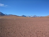
The Sairécabur volcanic group is a volcanic chain directly south of the Putana Volcano
, on the border between Bolivia
and Chile
. It contains at least 10 postglacial centers, the highest of which is Cerro Sairécabur at 5971 m (19,590 ft). The complex includes the mountains Cerro Saciel and Cerro Ojos del Toro, directly north of Sairécabur, as well as the stratovolcano
es volcán Curiquinca
(5722 m (18,773 ft)), volcán Escalante
or El Apagado (5819 m (19,091 ft)) and Cerro Colorado (5728 m (18,793 ft)), about 12 km (7 mi) to the north of Sairécabur. The complex also counts a number of abandoned sulfur mines, among which the "azufreras" Saciel, Ojos del Toro and El Apagado.
The word Sairécabur is the Castilianization of the Kunza
name used by the Atacameño
Likan-antay people to refer to the volcano: saire - rain, cabur - mountain, thus meaning "Rainmountain". The Cerro Sairécabur edifice rises at the northern end of a 4.5 km wide caldera
which is breached and intersected on the north-end by a 500 m (1,640 ft)-wide volcanic crater
.
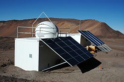
It is also the location of the Receiver Lab Telescope (RLT) at 5525 m (18,127 ft).
Putana Volcano
Putana is a stratovolcano on the border between Bolivia and Chile. It lies immediately NNE of Cerro Colorado, about north of Volcán Escalante, the northernmost member of the Sairecabur complex and south of the Cerros de Tocorpuri complex...
, on the border between Bolivia
Bolivia
Bolivia officially known as Plurinational State of Bolivia , is a landlocked country in central South America. It is the poorest country in South America...
and Chile
Chile
Chile ,officially the Republic of Chile , is a country in South America occupying a long, narrow coastal strip between the Andes mountains to the east and the Pacific Ocean to the west. It borders Peru to the north, Bolivia to the northeast, Argentina to the east, and the Drake Passage in the far...
. It contains at least 10 postglacial centers, the highest of which is Cerro Sairécabur at 5971 m (19,590 ft). The complex includes the mountains Cerro Saciel and Cerro Ojos del Toro, directly north of Sairécabur, as well as the stratovolcano
Stratovolcano
A stratovolcano, also known as a composite volcano, is a tall, conical volcano built up by many layers of hardened lava, tephra, pumice, and volcanic ash. Unlike shield volcanoes, stratovolcanoes are characterized by a steep profile and periodic, explosive eruptions...
es volcán Curiquinca
Curiquinca
Cerro Curiquinca is a stratovolcano that straddles the border between Bolivia and Chile. It lies immediately E of Cerro Colorado and NE to volcán Escalante , all of which are considered to be part of the Sairecabur volcanic group...
(5722 m (18,773 ft)), volcán Escalante
Escalante (El Apagado)
Volcán Escalante also known as "El Apagado" is a stratovolcano on the Chilean side of the border between Bolivia and Chile. It lies immediately SE of Cerro Colorado and SW to volcán Curiquinca, all of which are considered to be part of the Sairecabur volcanic group.-External links:* - Smithsonian...
or El Apagado (5819 m (19,091 ft)) and Cerro Colorado (5728 m (18,793 ft)), about 12 km (7 mi) to the north of Sairécabur. The complex also counts a number of abandoned sulfur mines, among which the "azufreras" Saciel, Ojos del Toro and El Apagado.
The word Sairécabur is the Castilianization of the Kunza
Kunza
Kunza Cunza, also known as Likanantaí, Lipe, Ulipe, or Atacameño, is an extinct, unclassified language spoken in the Atacama Desert of northern Chile and southern Perú by the Lickan-antay people, who have since shifted to Spanish.The last Kunza speaker was found in 1949, although some have...
name used by the Atacameño
Atacameño
The Atacameños are a Native American people who inhabited the Andean portion of the Atacama Desert, mainly in what is today Chile's Antofagasta Region. Their language is known as Kunza....
Likan-antay people to refer to the volcano: saire - rain, cabur - mountain, thus meaning "Rainmountain". The Cerro Sairécabur edifice rises at the northern end of a 4.5 km wide caldera
Caldera
A caldera is a cauldron-like volcanic feature usually formed by the collapse of land following a volcanic eruption, such as the one at Yellowstone National Park in the US. They are sometimes confused with volcanic craters...
which is breached and intersected on the north-end by a 500 m (1,640 ft)-wide volcanic crater
Volcanic crater
A volcanic crater is a circular depression in the ground caused by volcanic activity. It is typically a basin, circular in form within which occurs a vent from which magma erupts as gases, lava, and ejecta. A crater can be of large dimensions, and sometimes of great depth...
.
It is also the location of the Receiver Lab Telescope (RLT) at 5525 m (18,127 ft).
See also
- List of volcanoes in Bolivia
- List of volcanoes in Chile
- San Pedro de AtacamaSan Pedro de AtacamaSan Pedro de Atacama is a Chilean town and commune in El Loa Province, Antofagasta Region. It is located east of Antofagasta, some 106 km southeast of Calama and the Chuquicamata copper mine, overlooking the Licancabur volcano. It features a significant archeological museum, the R. P...
- LicancaburLicancaburLicancabur is a highly symmetrical stratovolcano on the southernmost part of the border between Chile and Bolivia. It is located just southwest of Laguna Verde in Bolivia. The volcano dominates the landscape of the Salar de Atacama area...
- Laguna Verde
- Putana VolcanoPutana VolcanoPutana is a stratovolcano on the border between Bolivia and Chile. It lies immediately NNE of Cerro Colorado, about north of Volcán Escalante, the northernmost member of the Sairecabur complex and south of the Cerros de Tocorpuri complex...
- TocorpuriTocorpuriCerros de Tocorpuri is a volcanic complex located along the border between Bolivia and Chile. Cerros de Tocorpuri's summit crater has a diameter of 1.4 km....
External links
- SI Google Earth Placemarks - Smithsonian Institution Global Volcanism Program: Download placemarks with SI Holocene volcano-data.