

Saint Regis Pond
Encyclopedia
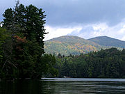
Saint Regis Canoe Area
The Saint Regis Canoe Area is a 19,000 acre area of the Adirondack Park in southern Franklin County, New York about 18 miles northeast of Tupper Lake and southwest of Paul Smiths....
in the Adirondacks in northern New York
New York
New York is a state in the Northeastern region of the United States. It is the nation's third most populous state. New York is bordered by New Jersey and Pennsylvania to the south, and by Connecticut, Massachusetts and Vermont to the east...
state. It drains into the west branch of the St. Regis River
St. Regis River
The St. Regis River is an river in northern New York in the USA. It flows into the Saint Lawrence River at the hamlet of St Regis in the St. Regis Mohawk Reservation. The Saint Regis River basin includes Upper and Lower St. Regis Lakes, and Saint Regis Pond in the Saint Regis Canoe Area.-External...
. It is the centerpiece of the "Seven Carries
Seven Carries
.The Seven Carries is an historic canoe route from Paul Smith's Hotel to the Saranac Inn through what is now known as the Saint Regis Canoe Area in southern Franklin County, New York in the Adirondack Park...
" canoe route.
The pond is 1.6 miles (2.6 km) long. There are four small islands and several designated campsite
Campsite
A campsite or camping pitch is a place used for overnight stay in the outdoors. In British English a campsite is an area, usually divided into a number of pitches, where people can camp overnight using tents or camper vans or caravans; this British English use of the word is synonymous with the...
s. Saint Regis Pond can only be reached by one or more carries
Portage
Portage or portaging refers to the practice of carrying watercraft or cargo over land to avoid river obstacles, or between two bodies of water. A place where this carrying occurs is also called a portage; a person doing the carrying is called a porter.The English word portage is derived from the...
from other ponds in the Canoe Area; the shortest route is via a 0.6 mile (0.965604 km) carry from Little Clear Pond after a 1.5 miles (2.4 km) paddle from the parking area on Floodwood Road.