

Sacramento, Minas Gerais
Encyclopedia
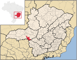
Minas Gerais
Minas Gerais is one of the 26 states of Brazil, of which it is the second most populous, the third richest, and the fourth largest in area. Minas Gerais is the Brazilian state with the largest number of Presidents of Brazil, the current one, Dilma Rousseff, being one of them. The capital is the...
. Its population as of 2007 was 22,159 people living in a total area of 3,071 km². The city belongs to the meso-region of Triângulo Mineiro and Alto Paranaíba and to the micro-region of Araxá. It became a municipality in 1820.
Location
Sacramento is located at an elevation of 832 (city center) meters, in the Rio das Velhas valley. Neighboring municipalities are: PerdizesPerdizes
Perdizes is a district in the subprefecture of Lapa, in São Paulo, Brazil.Built in an ancient area of Pacaembu Farm, Perdizes was historically considered only a poor rural area. Today, it is one of the most urbanized areas of São Paulo and known for being the home for the Pontifical Catholic...
(N), Araxá
Araxá
Araxá is a city and municipality in southwest Minas Gerais state, Brazil. The population was 87,764 inhabitants and the area of the municipality is 1,283 km², with 345 km² making up the urban perimeter.-Geography:...
and Tapira (NE), São Roque de Minas
São Roque de Minas
São Roque de Minas is a Brazilian municipality located in the west of the state of Minas Gerais. Its population as of 2007 was 6,141 people living in a total area of 2,100 km². The city belongs to the meso-region of Oeste de Minas and to the micro-region of Piumhi...
and Delfinópolis
Delfinópolis
Delfinópolis is a Brazilian municipality located in the southwest of the state of Minas Gerais. Its population as of 2007 was 6,698 people living in a total area of 1,375 km². The city belongs to the meso-region of Sul e Sudoeste de Minas and to the micro-region of Passos...
(SE), Ibiraci
Ibiraci
Ibiraci is a Brazilian municipality located in the southwest of the state of Minas Gerais. Its population as of 2007 was 11,023 people living in a total area of 598 km². The city belongs to the meso-region of Sul e Sudoeste de Minas and to the micro-region of Passos...
(S), Pedregulho
Pedregulho
Pedregulho is a municipality in the state of São Paulo in Brazil. The population in 2004 is 15,643 and the area is 702.72 km². The elevation is 1,035 m....
and Rifaina
Rifaina
Rifaina is a municipality in the state of São Paulo in Brazil. The population in 2004 was 3,545 and the area is 172.17 km². The elevation is 575 m....
(SW), Conquista
Conquista, Minas Gerais
Conquista is a Brazilian municipality located in the west of the state of Minas Gerais. Its population as of 2007 was estimated to be 6,580 people living in a total area of 616 km². The city belongs to the mesoregion of Triângulo Mineiro and Alto Paranaíba and to the micro-region of Uberaba. It...
and Uberaba
Uberaba
Uberaba is a city and municipality in the west of the state of Minas Gerais in Brazil. Its population is 296.000 with an area of 4529.7 km², giving a density of 60.71 people per km². It is located on a plateau at an elevation of 785 meters and is in the Uberaba River floodplain...
, and Nova Ponte
Nova Ponte
Nova Ponte is a Brazilian municipality located in the west of the state of Minas Gerais. Its population as of 2007 was estimated to be 11,586 people living in a total area of 1,105 km². The city belongs to the mesoregion of Triângulo Mineiro and Alto Paranaíba and to the micro-region of Araxá...
and Santa Juliana
Santa Juliana
Santa Juliana is a Brazilian municipality located in the west of the state of Minas Gerais. Its population as of 2007 was 10,582 people living in a total area of 727 km². The city belongs to the meso-region of Triângulo Mineiro and Alto Paranaíba and to the micro-region of Araxá...
(NW).
Communications and Distances
Sacramento is connected to UberabaUberaba
Uberaba is a city and municipality in the west of the state of Minas Gerais in Brazil. Its population is 296.000 with an area of 4529.7 km², giving a density of 60.71 people per km². It is located on a plateau at an elevation of 785 meters and is in the Uberaba River floodplain...
by state highway MG-190 and national highway BR-262. The distance to Uberaba
Uberaba
Uberaba is a city and municipality in the west of the state of Minas Gerais in Brazil. Its population is 296.000 with an area of 4529.7 km², giving a density of 60.71 people per km². It is located on a plateau at an elevation of 785 meters and is in the Uberaba River floodplain...
is 72 kilometers; Conquista
Conquista, Minas Gerais
Conquista is a Brazilian municipality located in the west of the state of Minas Gerais. Its population as of 2007 was estimated to be 6,580 people living in a total area of 616 km². The city belongs to the mesoregion of Triângulo Mineiro and Alto Paranaíba and to the micro-region of Uberaba. It...
is 22 km to the southwest; Araxá
Araxá
Araxá is a city and municipality in southwest Minas Gerais state, Brazil. The population was 87,764 inhabitants and the area of the municipality is 1,283 km², with 345 km² making up the urban perimeter.-Geography:...
is 82 km to the northeast. The nearest railroad is in Uberaba
Uberaba
Uberaba is a city and municipality in the west of the state of Minas Gerais in Brazil. Its population is 296.000 with an area of 4529.7 km², giving a density of 60.71 people per km². It is located on a plateau at an elevation of 785 meters and is in the Uberaba River floodplain...
.
Other distances
- Uberlândia: 180
- Ribeirão Preto: 190
- Franca: 100
- Belo Horizonte: 453
- Rio de Janeiro: 885
- São Paulo: 585
- Brasília: 604
- Vitória: 995
Economic Activities
The GDP in 2005 was approximately R$681 million, with 97 million reais from taxes, 132 million reais from services, 325 million reais from industry, and 125 million reais from agriculture. In 2005 there were 128 industrial units employing 1,325 workers. There were 976 rural producers on 155,000 hectares of land. The high elevation means the land is suitable for coffee growing. 355 farms had tractors (2006). Approximately 3,000 persons were dependent on agriculture. The main crops are coffee, potatoes, rice, soybeans, wheat, beans, and corn. There were 22,000 head of cattle (2006), most of which were raised for milk and cheese production.There were 4 banks (2007) and 4,764 automobiles (2007), giving a ratio of 5 inhabitants per automobile.
Health and Education
In the health sector there were 12 public health clinics (2005) and 1 private hospital with 68 beds. Patients with more serious health conditions are transported to Araxá or to Uberaba, which are connected by good roads. Educational needs were met by 14 primary schools, 4 middle schools, and 4 pre-primary schools.- Municipal Human Development IndexHuman Development IndexThe Human Development Index is a composite statistic used to rank countries by level of "human development" and separate "very high human development", "high human development", "medium human development", and "low human development" countries...
: 0.797 (2000) - State ranking: 49 out of 853 municipalities as of 2000
- National ranking: 629 out of 5,138 municipalities as of 2000
- Literacy rate: 90%
- Life expectancy: 73 (average of males and females)
In 2000 the per capita monthly income of R$272.00 was just below the state and national average of R$276.00 and R$297.00 respectively.
The highest ranking municipality in Minas Gerais in 2000 was Poços de Caldas
Poços de Caldas
Poços de Caldas is a city and municipality in south-western Minas Gerais state, Brazil, in the microregion of the same name. Its estimated population in 2009 was 151,449 inhabitants...
with 0.841, while the lowest was Setubinha
Setubinha
Setubinha is a municipality in the northeast of the Brazilian state of Minas Gerais. As of 2007 the population was 10,834 in a total area of 536 km². The elevation is 729 metres. It is part of the IBGE statistical microregion of Teófilo Otoni...
with 0.568. Nationally the highest was São Caetano do Sul
São Caetano do Sul
São Caetano do Sul is a city in São Paulo state in Brazil, located in the Greater São Paulo Metropolitan Area. It is the city with the highest per capita income in Brazil and it also has the highest Human Development Index .-Geography:São Caetano do Sul is located on a plateau that is part of the...
in São Paulo with 0.919, while the lowest was Setubinha. In more recent statistics (considering 5,507 municipalities) Manari in the state of Pernambuco
Pernambuco
Pernambuco is a state of Brazil, located in the Northeast region of the country. To the north are the states of Paraíba and Ceará, to the west is Piauí, to the south are Alagoas and Bahia, and to the east is the Atlantic Ocean. There are about of beaches, some of the most beautiful in the...
has the lowest rating in the country—0,467—putting it in last place.