

Nova Ponte
Encyclopedia
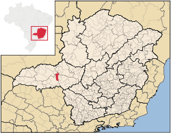
Minas Gerais
Minas Gerais is one of the 26 states of Brazil, of which it is the second most populous, the third richest, and the fourth largest in area. Minas Gerais is the Brazilian state with the largest number of Presidents of Brazil, the current one, Dilma Rousseff, being one of them. The capital is the...
. Its population as of 2007 was estimated to be 11,586 people living in a total area of 1,105 km². The city belongs to the mesoregion of Triângulo Mineiro and Alto Paranaíba and to the micro-region of Araxá. It became a municipality in 1938.
Location
Nova Ponte is located at an elevation of 791 meters, 70 km. east of UberlândiaUberlândia
Uberlândia is the main town in the Triangle region, west of the state of Minas Gerais, Brazil. With a population of 604,013 inhabitants, according to 2010 estimates, the city is the second largest in the state second only to Belo Horizonte...
on the western end of the Nova Ponte Represa. The distance to the state capital, Belo Horizonte
Belo Horizonte
Belo Horizonte is the capital of and largest city in the state of Minas Gerais, located in the southeastern region of Brazil. It is the third largest metropolitan area in the country...
, is 479 km. Neighboring municipalities are: Romaria
Romaria
Romaria is a Brazilian municipality located in the northwest of the state of Minas Gerais. Its population as of 2007 was 3,566 people living in a total area of 402 km². The city belongs to the mesoregion of Triângulo Mineiro e Alto Paranaíba and to the microregion of Patrocínio...
and Iraí de Minas
Iraí de Minas
Iraí de Minas is a Brazilian municipality located in the northwest of the state of Minas Gerais. Its population as of 2007 was 6,295 people living in a total area of 357 km². The city belongs to the mesoregion of Triângulo Mineiro e Alto Paranaíba and to the microregion of Patrocínio...
(N), Pedrinópolis
Pedrinópolis
Pedrinópolis is a Brazilian municipality located in the west of the state of Minas Gerais. Its population as of 2007 was 3,448 people living in a total area of 357 km². The city belongs to the meso-region of Triângulo Mineiro and Alto Paranaíba and to the micro-region of Araxá...
, Santa Juliana
Santa Juliana
Santa Juliana is a Brazilian municipality located in the west of the state of Minas Gerais. Its population as of 2007 was 10,582 people living in a total area of 727 km². The city belongs to the meso-region of Triângulo Mineiro and Alto Paranaíba and to the micro-region of Araxá...
, and Sacramento
Sacramento, Minas Gerais
Sacramento is a Brazilian municipality located in the west of the state of Minas Gerais. Its population as of 2007 was 22,159 people living in a total area of 3,071 km². The city belongs to the meso-region of Triângulo Mineiro and Alto Paranaíba and to the micro-region of Araxá...
(E), Uberaba
Uberaba
Uberaba is a city and municipality in the west of the state of Minas Gerais in Brazil. Its population is 296.000 with an area of 4529.7 km², giving a density of 60.71 people per km². It is located on a plateau at an elevation of 785 meters and is in the Uberaba River floodplain...
(S and W), Indianópolis
Indianópolis
Indianópolis is a Brazilian municipality located in the west of the state of Minas Gerais. Its population as of 2007 was 6,244 living in a total area of 834 km². The city belongs to the statistical mesoregion of Triângulo Mineiro and Alto Paranaíba and to the statistical microregion of Uberlândia. ...
(NW).
Communications
Nova Ponte is connected to one of the most important export corridors in Brazil by way of the Ferrovia Central Atlântica.Weather Facts
- Average annual maximum temperature: 29.1°C
- Average annual minimum temperature: 16.6°C
- Average annual rainfall: 1,589 mm
Economic activities
The GDP in 2005 was approximately R$441 million, with 70 million reais from services, 218 million reais from industry, and 85 million reais from agriculture. Nova Ponte receives royalties from the hydroelectric plant—Usina Hidrelétrica de Nova Ponte. There were 358 rural producers on 69,000 hectares of land. The land is very fertile and agricultural production is high. 131 farms had tractors (2006). Approximately 1,600 persons were dependent on agriculture. The main crops are coffee, sugarcane, soybeans, potatoes, and corn. There were 32,000 head of cattle (2006) and almost one million chickens.There were 2 banks (2007) and 1,445 automobiles (2007), giving a ratio of 8 inhabitants per automobile.
Health and education
In the health sector there were 3 public health clinics and 1 hospital with 16 beds (2005). Patients with more serious health conditions are transported to Uberaba or to Uberlândia, which are connected by good roads. Educational needs were met by 7 primary schools, 1 middle school, and 4 pre-primary schools.- Municipal Human Development IndexHuman Development IndexThe Human Development Index is a composite statistic used to rank countries by level of "human development" and separate "very high human development", "high human development", "medium human development", and "low human development" countries...
: 0.803 (2000) - State ranking: 33 out of 853 municipalities as of 2000
- National ranking: 497 out of 5,138 municipalities as of 2000
- Literacy rate: 88%
- Life expectancy: 74 (average of males and females)
In 2000 the per capita monthly income of R$305.00 was above the state and national average of R$276.00 and R$297.00 respectively.
The highest ranking municipality in Minas Gerais in 2000 was Poços de Caldas
Poços de Caldas
Poços de Caldas is a city and municipality in south-western Minas Gerais state, Brazil, in the microregion of the same name. Its estimated population in 2009 was 151,449 inhabitants...
with 0.841, while the lowest was Setubinha
Setubinha
Setubinha is a municipality in the northeast of the Brazilian state of Minas Gerais. As of 2007 the population was 10,834 in a total area of 536 km². The elevation is 729 metres. It is part of the IBGE statistical microregion of Teófilo Otoni...
with 0.568. Nationally the highest was São Caetano do Sul
São Caetano do Sul
São Caetano do Sul is a city in São Paulo state in Brazil, located in the Greater São Paulo Metropolitan Area. It is the city with the highest per capita income in Brazil and it also has the highest Human Development Index .-Geography:São Caetano do Sul is located on a plateau that is part of the...
in São Paulo with 0.919, while the lowest was Setubinha. In more recent statistics (considering 5,507 municipalities) Manari in the state of Pernambuco
Pernambuco
Pernambuco is a state of Brazil, located in the Northeast region of the country. To the north are the states of Paraíba and Ceará, to the west is Piauí, to the south are Alagoas and Bahia, and to the east is the Atlantic Ocean. There are about of beaches, some of the most beautiful in the...
has the lowest rating in the country—0,467—putting it in last place.