

Conquista, Minas Gerais
Encyclopedia
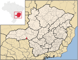
Minas Gerais
Minas Gerais is one of the 26 states of Brazil, of which it is the second most populous, the third richest, and the fourth largest in area. Minas Gerais is the Brazilian state with the largest number of Presidents of Brazil, the current one, Dilma Rousseff, being one of them. The capital is the...
. Its population as of 2007 was estimated to be 6,580 people living in a total area of 616 km². The city belongs to the mesoregion of Triângulo Mineiro and Alto Paranaíba and to the micro-region of Uberaba. It became a municipality in 1912.
Conquista is located at an elevation of 673 meters, 55 km. southeast of Uberaba
Uberaba
Uberaba is a city and municipality in the west of the state of Minas Gerais in Brazil. Its population is 296.000 with an area of 4529.7 km², giving a density of 60.71 people per km². It is located on a plateau at an elevation of 785 meters and is in the Uberaba River floodplain...
. The distance to the state capital, Belo Horizonte
Belo Horizonte
Belo Horizonte is the capital of and largest city in the state of Minas Gerais, located in the southeastern region of Brazil. It is the third largest metropolitan area in the country...
, is 469 km. Neighboring municipalities are: Uberaba
Uberaba
Uberaba is a city and municipality in the west of the state of Minas Gerais in Brazil. Its population is 296.000 with an area of 4529.7 km², giving a density of 60.71 people per km². It is located on a plateau at an elevation of 785 meters and is in the Uberaba River floodplain...
(NW and W), Sacramento
Sacramento, Minas Gerais
Sacramento is a Brazilian municipality located in the west of the state of Minas Gerais. Its population as of 2007 was 22,159 people living in a total area of 3,071 km². The city belongs to the meso-region of Triângulo Mineiro and Alto Paranaíba and to the micro-region of Araxá...
(NE), Refaina (S) and Igarapava
Igarapava
Igarapava is a municipality in the state of São Paulo in Brazil. The population in 2004 is 27,773 and the area is 468.51 km². The elevation is 576 m. This place name comes from the Tupi language....
(SE) The southern boundary is formed by the Rio Grande River.
The population was once much greater but decreased with the collapse of the coffee market in the early twentieth century and the later exodus of workers to build the new capital of Brasília
Brasília
Brasília is the capital city of Brazil. The name is commonly spelled Brasilia in English. The city and its District are located in the Central-West region of the country, along a plateau known as Planalto Central. It has a population of about 2,557,000 as of the 2008 IBGE estimate, making it the...
in the 1960s. In 1920 Conquista had 20,170 inhabitants; in 1950 there were 11,627; in 1980 there were 7,300, and in 2000 there were 6,101, of which 4,037 lived in the urban area.
The main economic activities are services, industry and agriculture. Industry employed over 3,000 people, many of them in a sugar and alcohol factory. The GDP in 2005 was approximately R$117 million, with 31 million reais from services, 30 million reais from industry, and 47 million reais from agriculture. There were 300 rural producers on 32,000 hectares of land. 300 workers were employed by the industrial sector. The land is very fertile and agricultural production is high. 125 farms had tractors (2006). Approximately 900 persons were employed by agriculture. The main crops were sugarcane (10,000 hectares planted in 2006)) and soybeans (8,700 hectares planted in 2006), but oranges, cotton, rice, beans and corn were also grown. There were 28,000 head of cattle (2006). There were 2 banks (2007) and 1,071 automobiles, giving a ratio of 6 inhabitants per automobile.
There were 6 health clinics and 1 hospital with 31 beds (2005). Patients with more serious health conditions are transported to Uberaba, which is connected by good roads. Educational needs were met by 4 primary schools, 1 middle school, and 5 pre-primary schools (2007).
- Municipal Human Development IndexHuman Development IndexThe Human Development Index is a composite statistic used to rank countries by level of "human development" and separate "very high human development", "high human development", "medium human development", and "low human development" countries...
: 0.779 (2000) - State ranking: 119 out of 853 municipalities as of 2000
- National ranking: 1,081 out of 5,138 municipalities as of 2000
- Literacy rate: 87%
- Life expectancy: 71 (average of males and females)
In 2000 the per capita monthly income of R$268.00 was below the state and national average of R$276.00 and R$297.00 respectively.
The highest ranking municipality in Minas Gerais in 2000 was Poços de Caldas
Poços de Caldas
Poços de Caldas is a city and municipality in south-western Minas Gerais state, Brazil, in the microregion of the same name. Its estimated population in 2009 was 151,449 inhabitants...
with 0.841, while the lowest was Setubinha
Setubinha
Setubinha is a municipality in the northeast of the Brazilian state of Minas Gerais. As of 2007 the population was 10,834 in a total area of 536 km². The elevation is 729 metres. It is part of the IBGE statistical microregion of Teófilo Otoni...
with 0.568. Nationally the highest was São Caetano do Sul
São Caetano do Sul
São Caetano do Sul is a city in São Paulo state in Brazil, located in the Greater São Paulo Metropolitan Area. It is the city with the highest per capita income in Brazil and it also has the highest Human Development Index .-Geography:São Caetano do Sul is located on a plateau that is part of the...
in São Paulo with 0.919, while the lowest was Setubinha. In more recent statistics (considering 5,507 municipalities) Manari in the state of Pernambuco
Pernambuco
Pernambuco is a state of Brazil, located in the Northeast region of the country. To the north are the states of Paraíba and Ceará, to the west is Piauí, to the south are Alagoas and Bahia, and to the east is the Atlantic Ocean. There are about of beaches, some of the most beautiful in the...
has the lowest rating in the country--0,467--putting it in last place.