
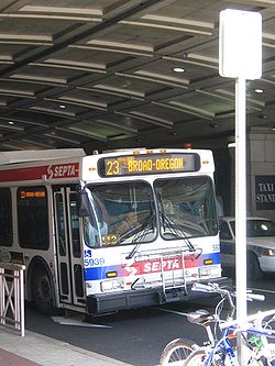
SEPTA Route 23
Encyclopedia
Tram
A tram is a passenger rail vehicle which runs on tracks along public urban streets and also sometimes on separate rights of way. It may also run between cities and/or towns , and/or partially grade separated even in the cities...
line and currently operated by bus
Bus
A bus is a road vehicle designed to carry passengers. Buses can have a capacity as high as 300 passengers. The most common type of bus is the single-decker bus, with larger loads carried by double-decker buses and articulated buses, and smaller loads carried by midibuses and minibuses; coaches are...
. It is operated by the Southeastern Pennsylvania Transportation Authority
Southeastern Pennsylvania Transportation Authority
The Southeastern Pennsylvania Transportation Authority is a metropolitan transportation authority that operates various forms of public transit—bus, subway and elevated rail, commuter rail, light rail, and electric trolley bus—that serve 3.9 million people in and around Philadelphia,...
(SEPTA) in Philadelphia, Pennsylvania
Pennsylvania
The Commonwealth of Pennsylvania is a U.S. state that is located in the Northeastern and Mid-Atlantic regions of the United States. The state borders Delaware and Maryland to the south, West Virginia to the southwest, Ohio to the west, New York and Ontario, Canada, to the north, and New Jersey to...
, United States
United States
The United States of America is a federal constitutional republic comprising fifty states and a federal district...
. The line runs between the Chestnut Hill
Chestnut Hill, Philadelphia, Pennsylvania
Chestnut Hill is a neighborhood in the Northwest Philadelphia section of the United States city of Philadelphia, Pennsylvania.-Boundaries:Chestnut Hill is bounded as follows:...
and South Philadelphia
South Philadelphia
South Philadelphia, nicknamed South Philly, is the section of Philadelphia bounded by South Street to the north, the Delaware River to the east and south, and the Schuylkill River to the west.-History:...
neighborhoods via Germantown Avenue, 11th, 12th Streets.
Route 23 was Philadelphia's longest streetcar route, and was one of three suspended by the SEPTA board in 1992. The two others, routes 15 and 56
SEPTA Route 56
SEPTA's Trolley Route 56, the Erie & Torresdale Avenues Line is a streetcar line and is currently operated by bus, it is operated by the Southeastern Pennsylvania Transportation Authority in Philadelphia, Pennsylvania, United States. The line runs between the Tioga and Tacony neighborhoods...
, were then also operated by buses, although light-rail service on Route 15 was restored in 2005.
Route
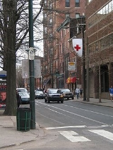
Route 23 begins in South Philadelphia. The southern terminus is at the intersection of Broad StreetBroad Street (Philadelphia)
Broad Street is a major arterial street in Philadelphia, Pennsylvania, and is nearly 13 miles long.It is Pennsylvania Route 611 along its entire length with the exception of its northernmost part between Old York Road and Pennsylvania Route 309 and the southernmost part south of Interstate 95...
and Oregon Avenue, on the block that also consists of 10th Street and Packer Avenue. From Oregon Avenue the line runs north on 11th Street and south on 12th Street. North of Tasker Avenue, the straight path of 11th Street is briefly interrupted at Passyunk Avenue (due to the former presence of Moyamensing Prison
Moyamensing Prison
Moyamensing Prison was a prison in Philadelphia, Pennsylvania, designed by Thomas U. Walter and completed in 1835.-History:The prison's cornerstone was laid April 2, 1832, and it was finished in 1835...
, demolished in the 1960s), which Northbound Route 23 moves to until it turns west onto Reed Street before getting back to 11th Street. After running through Center City, northbound Route 23 turns east to Susquehanna Avenue and then north again to 10th Street, and southbound Route 23 moves from 10th Street west to Huntingdon Street to and south again to 11th Street. North of Cecil B. Moore (formerly Columbia) Avenue
Cecil B. Moore Avenue
Cecil B. Moore Avenue, also known as Columbia Avenue, is a major arterial street in Philadelphia, Pennsylvania which is divided East and West between the city's Fishtown and Overbrook communities. East of Frankford Avenue, the street is known by its original name, East Columbia Avenue, from...
, Route 23 then continues northwest on Germantown Avenue through North Philadelphia, which includes a six-way intersection with Erie Avenue, which carries SEPTA Routes 53
SEPTA Route 53
SEPTA Route 53 is a former street car line and current bus route, operated by the Southeastern Pennsylvania Transportation Authority in Philadelphia, Pennsylvania, United States. The line runs between the West Mount Airy and Hunting Park neighborhoods primarily along Wayne Avenue.-Route...
and 56
SEPTA Route 56
SEPTA's Trolley Route 56, the Erie & Torresdale Avenues Line is a streetcar line and is currently operated by bus, it is operated by the Southeastern Pennsylvania Transportation Authority in Philadelphia, Pennsylvania, United States. The line runs between the Tioga and Tacony neighborhoods...
and Broad Street
Broad Street (Philadelphia)
Broad Street is a major arterial street in Philadelphia, Pennsylvania, and is nearly 13 miles long.It is Pennsylvania Route 611 along its entire length with the exception of its northernmost part between Old York Road and Pennsylvania Route 309 and the southernmost part south of Interstate 95...
all of which are over Erie Station on the Broad Street Subway Line. Routes 53 and 56 are two other former street car lines that were converted into bus routes. Another major connection along the route is the Wayne Junction
Wayne Junction (SEPTA station)
Wayne Junction is a SEPTA Regional Rail station located at 4481 Wayne Avenue, extending along Windrim Avenue to Germantown Avenue, bordering the Nicetown and Germantown neighborhoods of Philadelphia, Pennsylvania.-Station:...
commuter railroad station. As Route 23 transitions from North Philadelphia to Northwest Philadelphia
Northwest Philadelphia
Northwest Philadelphia is a section of the city of Philadelphia, Pennsylvania. The official boundary is Stenton Avenue to the north, the Schuylkill river to the south, Spring Ln to the west, and Wister Street to the east. The area is divided by Wissahickon Creek into two subsections...
, it runs through Germantown
Germantown, Philadelphia, Pennsylvania
Germantown is a neighborhood in the northwest section of the city of Philadelphia, Pennsylvania, United States, about 7–8 miles northwest from the center of the city...
and Mount Airy into Chestnut Hill. The northern terminus is currently located at the intersection of Germantown Avenue and Bethlehem Pike Loop, which is located in between SEPTA's Chestnut Hill West
Chestnut Hill West (SEPTA station)
Chestnut Hill West Station is a SEPTA Regional Rail station at 9 West Evergreen Avenue off Germantown Avenue, Chestnut Hill, Philadelphia, Pennsylvania. The station was originally built by the Philadelphia, Germantown and Chestnut Hill Railroad between 1883 and 1884, and acquired by the...
and East
Chestnut Hill East (SEPTA station)
Chestnut Hill East Station is a SEPTA Regional Rail station at 102–04 Bethlehem Pike at Chestnut Hill Avenue, Philadelphia, Pennsylvania. The current station building was built in 1931 by the Reading Railroad....
regional railroad stations.
The lengthy Route 23 utilizes several short-turn loops or cross-street cutbacks to allow for operational flexibility. Those in the SEPTA era have included: Germantown & Mermaid, Germantown & Gorgas (a large universal loop serving Germantown Depot), Germantown & Venango (later moved to Germantown & Ontario; both were the cutback to get to Luzerne Depot), 10th & Susquehanna, 12th & Bainbridge, and 12th & Snyder.
History
Route 23 was established sometime prior to 1877 as the Germantown Avenue Line, and ran from Germantown Depot to 8th and Dauphin Streets. In 1890 the line was extended to the 4th and 8th Street trolleys and renamed the Pelham Line. It was combined with the "Mermaid and Chestnut Hill Line" in 1913, and renamed the "Germantown, 10th and 11th Streets Line." The northern terminus was extended to the Bethlehem Pike Loop in 1920, while the southern terminus was extended to 11th Street and Pattison Avenue in 1926, and to 10th Street and Bigler Avenue in 1957. At the same time as the latter change, the Route 20 trolley on 12th and 13th Streets was abandoned by combining it with the 23, which thereafter operated on 11th and 12th Streets just as it does today.PCC cars
PCC streetcar
The PCC streetcar design was first built in the United States in the 1930s. The design proved successful in its native country, and after World War II was licensed for use elsewhere in the world...
were introduced to the line in 1947 and 1948, replacing Nearside cars
Nearside streetcar
The Nearside streetcar or Nearside car was an American type of tramcar that was invented by the president of the governing board Council of the Philadelphia Rapid Transit Company Thomas E. Mitten. It was the basis for one man service and must be seen as a preamble of the Peter Witt streetcar. By...
which had operated the route since the teens. The Philadelphia Transportation Company (PTC) attempted to introduce a fleet of 100 PCCs to the line in 1942, but an insufficient power supply for climbing Chestnut Hill caused these cars to be sent to Luzerne Depot to serve other routes instead. After World War II
World War II
World War II, or the Second World War , was a global conflict lasting from 1939 to 1945, involving most of the world's nations—including all of the great powers—eventually forming two opposing military alliances: the Allies and the Axis...
and its materials shortages and restrictions ended, a substation
Electrical substation
A substation is a part of an electrical generation, transmission, and distribution system. Substations transform voltage from high to low, or the reverse, or perform any of several other important functions...
was built at Germantown Avenue and Mermaid Lane, and PTC assigned 85 new PCCs to the line; the difference in number of cars was due to postwar ridership declines.
On September 5, 1976, the Route 23 trolleys were moved from Germantown Depot to Luzerne Depot, making Luzerne the operating depot for the six remaining North Philadelphia streetcar routes: 6, 23, 50
SEPTA Route 50
SEPTA Trolley Route 50 is a former street car line and current bus route, operated by the Southeastern Pennsylvania Transportation Authority in Philadelphia, Pennsylvania, United States....
, 53
SEPTA Route 53
SEPTA Route 53 is a former street car line and current bus route, operated by the Southeastern Pennsylvania Transportation Authority in Philadelphia, Pennsylvania, United States. The line runs between the West Mount Airy and Hunting Park neighborhoods primarily along Wayne Avenue.-Route...
, 56
SEPTA Route 56
SEPTA's Trolley Route 56, the Erie & Torresdale Avenues Line is a streetcar line and is currently operated by bus, it is operated by the Southeastern Pennsylvania Transportation Authority in Philadelphia, Pennsylvania, United States. The line runs between the Tioga and Tacony neighborhoods...
, and 60
SEPTA Route 60
SEPTA's Trolley Route 60, the Allegheny Avenue Line is a former streetcar line and current bus route, operated by the Southeastern Pennsylvania Transportation Authority in Northwest and Northeast Philadelphia, Pennsylvania, United States...
. A pamphlet was issued by SEPTA informing the Route 23 operators of this change. After the move, the route's PCC all-electric cars were replaced with prewar PCC "air cars", which incorporated the use of pressurized air to power certain aspects of the car (such as sanders for traction) in order to provide greater reliability on Germantown Avenue's hills.
By this time, only two trolley lines operated from Luzerne: routes 23 and 56. Along these last two routes, diesels buses were often substituted for months at a time, whenever utility construction occurred along those routes. Gone were the days when contractors were instructed to work around the streetcars. It was simply easier to suspend trolley service.
In 1992, the streetcar service along route 23 was suspended and replaced by bus service. Up to 1992, it has been disputed that route 23 was the longest streetcar route in the United States - if not the world. As of 2006, route 23 was SEPTA's most heavily traveled surface route, with a daily ridership averaging 20,113. All buses are ADA
Americans with Disabilities Act of 1990
The Americans with Disabilities Act of 1990 is a law that was enacted by the U.S. Congress in 1990. It was signed into law on July 26, 1990, by President George H. W. Bush, and later amended with changes effective January 1, 2009....
-compliant, and contain bicycle racks. "Night Owl" service is also available. In 2010 plans were to restore service between 2011 and 2018. However in 2011 it was pushed back to 2015-2022 and the proposed 2012 budget pushes it back even further to 2016-2023.