
Rude Britain
Encyclopedia
Rude Britain is a 2005 book
of British place names with seemingly rude or offensive meanings. The book (ISBN 0-7522-2581-2) is written by Rob Bailey and Ed Hurst, and published in the United Kingdom
by the Pan Macmillan
imprint
Boxtree.
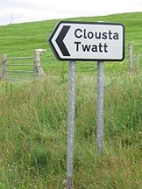
Each of the 100 names chosen by the authors is accompanied by a photograph and a placename etymology
. The etymologies are often due to Great Britain
's history of repeated invasion, occupation, and assimilation, combined with a human predilection for double entendre
s.
 Entries include North Piddle (from the Old English
word pidele, meaning marsh
), Pratt's Bottom
, Ugley
, Titty Ho, and Spital-in-the-Street
(a hamlet
in Lincolnshire
with a name based on the Middle English
spitel, meaning hospital).
2005 in literature
The year 2005 in literature involved some significant events and new books.-Events:*February 25 - Canada Reads selects Rockbound by Frank Parker Day as the novel to be read across the nation....
of British place names with seemingly rude or offensive meanings. The book (ISBN 0-7522-2581-2) is written by Rob Bailey and Ed Hurst, and published in the United Kingdom
United Kingdom
The United Kingdom of Great Britain and Northern IrelandIn the United Kingdom and Dependencies, other languages have been officially recognised as legitimate autochthonous languages under the European Charter for Regional or Minority Languages...
by the Pan Macmillan
Macmillan Publishers
Macmillan Publishers Ltd, also known as The Macmillan Group, is a privately held international publishing company owned by Georg von Holtzbrinck Publishing Group. It has offices in 41 countries worldwide and operates in more than thirty others.-History:...
imprint
Imprint
In the publishing industry, an imprint can mean several different things:* As a piece of bibliographic information about a book, it refers to the name and address of the book's publisher and its date of publication as given at the foot or on the verso of its title page.* It can mean a trade name...
Boxtree.
Each of the 100 names chosen by the authors is accompanied by a photograph and a placename etymology
Etymology
Etymology is the study of the history of words, their origins, and how their form and meaning have changed over time.For languages with a long written history, etymologists make use of texts in these languages and texts about the languages to gather knowledge about how words were used during...
. The etymologies are often due to Great Britain
Great Britain
Great Britain or Britain is an island situated to the northwest of Continental Europe. It is the ninth largest island in the world, and the largest European island, as well as the largest of the British Isles...
's history of repeated invasion, occupation, and assimilation, combined with a human predilection for double entendre
Double entendre
A double entendre or adianoeta is a figure of speech in which a spoken phrase is devised to be understood in either of two ways. Often the first meaning is straightforward, while the second meaning is less so: often risqué or ironic....
s.
Old English language
Old English or Anglo-Saxon is an early form of the English language that was spoken and written by the Anglo-Saxons and their descendants in parts of what are now England and southeastern Scotland between at least the mid-5th century and the mid-12th century...
word pidele, meaning marsh
Marsh
In geography, a marsh, or morass, is a type of wetland that is subject to frequent or continuous flood. Typically the water is shallow and features grasses, rushes, reeds, typhas, sedges, other herbaceous plants, and moss....
), Pratt's Bottom
Pratt's Bottom
Pratt's Bottom is a village in the London Borough of Bromley, located at the south eastern boundary of Greater London with Kent. It is adjacent to Biggin Hill Airport....
, Ugley
Ugley
Ugley is a small hamlet in the non-metropolitan district of Uttlesford in Essex, England. It is about a mile north of Stansted Mountfitchet, and located between Saffron Walden and Bishop's Stortford....
, Titty Ho, and Spital-in-the-Street
Spital-in-the-Street
Spital-in-the-Street is a small hamlet in Lincolnshire, England. It is on the Roman Ermine Street , which forms the modern A15 road, near its junction with the A631 road, known as Caenby Corner, north of Lincoln...
(a hamlet
Hamlet (place)
A hamlet is usually a rural settlement which is too small to be considered a village, though sometimes the word is used for a different sort of community. Historically, when a hamlet became large enough to justify building a church, it was then classified as a village...
in Lincolnshire
Lincolnshire
Lincolnshire is a county in the east of England. It borders Norfolk to the south east, Cambridgeshire to the south, Rutland to the south west, Leicestershire and Nottinghamshire to the west, South Yorkshire to the north west, and the East Riding of Yorkshire to the north. It also borders...
with a name based on the Middle English
Middle English
Middle English is the stage in the history of the English language during the High and Late Middle Ages, or roughly during the four centuries between the late 11th and the late 15th century....
spitel, meaning hospital).