
.gif)
Route 83 (New Jersey)
Encyclopedia
Route 83 is a state highway
in the U.S. state
of New Jersey
. It is completely within Dennis Township, New Jersey
, running 3.81 mi (6.13 km) from an intersection with Route 47 to an intersection with U.S. Route 9. The route, which passes through woodland and some residential development, is also known as the Trooper Bertram T. Zimmerman III Memorial Highway in honor of a New Jersey State Police
officer who was killed along Route 83 in 2004 while responding to an armed robbery.
Between 1927 and 1953, Route 83 was a part of Route 49, which originally ran south of Millville
along Route 47 between Millville and South Dennis
and along the entire length of Route 83. In 1953, the route became Route 83 when Route 49 was realigned to follow Route 47 between Millville and Tuckahoe
and Route 47 was aligned to follow Route S49 between South Dennis and Rio Grande
. In 2007, the state completed reconstruction of the intersection with Route 47 to include a traffic signal. A school bus accident has prompted the NJDOT to install a traffic signal at the Y-intersection of Route 83 and U.S. Route 9.
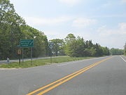 Route 83 begins at a traffic light with Route 47 in South Dennis
, heading to the east on a four-lane divided highway
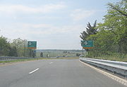
. The route crosses over the Cape May Seashore Lines
railroad line and narrows to a two-lane undivided highway. After this bridge, it intersects West Avenue and then crosses over County Route 628 (Dennisville Road/School House Road). Route 83 then intersects County Road, which heads west to parallel the route to the south. It later crosses Gravel Hole Road, which provides access to County Route 657 (Court House-Dennisville Road). Past that intersection, Route 83 continues to the east through a mix of residential development and woodland. It passes under a set of power line
s and comes to an intersection with County Route 608 (Kings Highway). The route continues east to its eastern terminus at a Y-intersection with U.S. Route 9 in Clermont.
Route 83 is a major route that provides access to the Jersey Shore
resorts of Sea Isle City
and Avalon
from Route 47. It also serves as part of an evacuation
route for Cape May County that feeds into Route 47 to provide access to inland areas in the event of a hurricane.
 Route 83 was originally legislated by the Laws of 1927, Chapter 319
as a part of Route 49, which was to run from Route 4 (now U.S. Route 9) in Ocean View
to Route 44 in Salem
. In 1940, the route was realigned through South Dennis
to cross over the Pennsylvania-Reading Seashore Lines
railroad tracks on a bridge. The original alignment, which had its crossing with the railroad tracks blocked, remains as County Road. In the 1953 New Jersey state highway renumbering
, Route 49 was realigned to head along Route 47 from Millville
to Tuckahoe
, Route 47 was realigned to head along Route 49 between Millville and South Dennis and Route S49 from South Dennis and Rio Grande
, and Route 83 was created along the former alignment of Route 49 between South Dennis and Clermont.
On December 12, 2004, Route 83 was dedicated as the Trooper Bertram T. Zimmerman III Memorial Highway in honor of a New Jersey State Police
trooper who was killed on the route earlier in the year while responding to an armed robbery. In the 2000s, plans were made to improve the intersections at both termini of Route 83. The intersection with Route 47 saw realignment and the installation of a traffic light, along with improvements to Route 47, that cost $6.7 million and was completed in July 2007. In 2006, reconstruction of the Y-intersection of U.S. Route 9 and Route 83 to feature realignment and a new traffic light was planned following a school bus accident.
State highway
State highway, state road or state route can refer to one of three related concepts, two of them related to a state or provincial government in a country that is divided into states or provinces :#A...
in the U.S. state
U.S. state
A U.S. state is any one of the 50 federated states of the United States of America that share sovereignty with the federal government. Because of this shared sovereignty, an American is a citizen both of the federal entity and of his or her state of domicile. Four states use the official title of...
of New Jersey
New Jersey
New Jersey is a state in the Northeastern and Middle Atlantic regions of the United States. , its population was 8,791,894. It is bordered on the north and east by the state of New York, on the southeast and south by the Atlantic Ocean, on the west by Pennsylvania and on the southwest by Delaware...
. It is completely within Dennis Township, New Jersey
Dennis Township, New Jersey
Dennis Township is a township in Cape May County, New Jersey, United States. It is part of the Ocean City Metropolitan Statistical Area. The township population was 6,492 as of the United States 2000 Census...
, running 3.81 mi (6.13 km) from an intersection with Route 47 to an intersection with U.S. Route 9. The route, which passes through woodland and some residential development, is also known as the Trooper Bertram T. Zimmerman III Memorial Highway in honor of a New Jersey State Police
New Jersey State Police
The New Jersey State Police is the state police force for the state of New Jersey. It is a general-powers police agency with state wide jurisdiction when requested by the Governor, designated by Troop Sectors.-History:...
officer who was killed along Route 83 in 2004 while responding to an armed robbery.
Between 1927 and 1953, Route 83 was a part of Route 49, which originally ran south of Millville
Millville, New Jersey
Millville is a city in Cumberland County, New Jersey, United States. As of the 2000 United States Census, the city population was 26,847. Millville, Bridgeton and Vineland are the three principal New Jersey cities of the Vineland-Millville-Bridgeton Primary Metropolitan Statistical Area which...
along Route 47 between Millville and South Dennis
South Dennis, New Jersey
South Dennis is an unincorporated area in Dennis Township, in Cape May County, New Jersey, United States. It is part of the Ocean City Metropolitan Statistical Area. Its postal ZIP Code is 08245.-Demographics:...
and along the entire length of Route 83. In 1953, the route became Route 83 when Route 49 was realigned to follow Route 47 between Millville and Tuckahoe
Tuckahoe, New Jersey
Tuckahoe is an unincorporated community in Upper Township, Cape May County, New Jersey, United States.-Bridge construction:A bridge, constructed in 1920 and renovated in 1962, connects Tuckahoe to Corbin City, its neighbor to the north...
and Route 47 was aligned to follow Route S49 between South Dennis and Rio Grande
Rio Grande, New Jersey
Rio Grande is a census-designated place and unincorporated area located within Middle Township, in Cape May County, New Jersey. It is part of the Ocean City Metropolitan Statistical Area...
. In 2007, the state completed reconstruction of the intersection with Route 47 to include a traffic signal. A school bus accident has prompted the NJDOT to install a traffic signal at the Y-intersection of Route 83 and U.S. Route 9.
Route description
South Dennis, New Jersey
South Dennis is an unincorporated area in Dennis Township, in Cape May County, New Jersey, United States. It is part of the Ocean City Metropolitan Statistical Area. Its postal ZIP Code is 08245.-Demographics:...
, heading to the east on a four-lane divided highway
Divided Highway
Divided Highway is a compilation album by American rock band The Doobie Brothers, released in 2003. . All tracks are taken from the albums Cycles and Brotherhood .-Track listing:...
. The route crosses over the Cape May Seashore Lines
Cape May Seashore Lines
Cape May Seashore Lines is a short line railroad in southern New Jersey. It offers two excursion services; a 30-mile round trip between Richland and Tuckahoe, and a 14-mile round trip between Rio Grande, Cold Spring Village, and Cape May City. The track is owned by New Jersey Transit and leased to...
railroad line and narrows to a two-lane undivided highway. After this bridge, it intersects West Avenue and then crosses over County Route 628 (Dennisville Road/School House Road). Route 83 then intersects County Road, which heads west to parallel the route to the south. It later crosses Gravel Hole Road, which provides access to County Route 657 (Court House-Dennisville Road). Past that intersection, Route 83 continues to the east through a mix of residential development and woodland. It passes under a set of power line
Power Line
Power Line is an American political blog, providing news and commentary from a conservative point-of-view. It was originally written by three lawyers who attended Dartmouth College together: John H. Hinderaker, Scott W. Johnson, and Paul Mirengoff...
s and comes to an intersection with County Route 608 (Kings Highway). The route continues east to its eastern terminus at a Y-intersection with U.S. Route 9 in Clermont.
Route 83 is a major route that provides access to the Jersey Shore
Jersey Shore
The Jersey Shore is a term used to refer to both the Atlantic coast of the U.S. state of New Jersey and the adjacent resort and residential communities. . The New Jersey State Department of Tourism considers the Shore Region, Greater Atlantic City, and the Southern Shore to be distinct, each having...
resorts of Sea Isle City
Sea Isle City, New Jersey
Sea Isle City is a city in Cape May County, New Jersey, United States. It is part of the Ocean City Metropolitan Statistical Area. As of the 2010 United States Census, the city population was 2,114. Visitors raise the population to as much as 40,000 during the peak summer season from Memorial Day...
and Avalon
Avalon, New Jersey
As of April 2009, the average home sales price in Avalon was $1,567,662 .As of the census of 2000, there were 2,143 people, 1,045 households, and 668 families residing in the borough. The population density was 508.4 people per square mile...
from Route 47. It also serves as part of an evacuation
Emergency evacuation
Emergency evacuation is the immediate and rapid movement of people away from the threat or actual occurrence of a hazard. Examples range from the small scale evacuation of a building due to a bomb threat or fire to the large scale evacuation of a district because of a flood, bombardment or...
route for Cape May County that feeds into Route 47 to provide access to inland areas in the event of a hurricane.
History
1927 New Jersey state highway renumbering
In 1927, New Jersey's state highways were renumbered. The old system, which had been defined in sequence by the legislature, was growing badly, as several routes shared the same number, and many unnumbered state highways had been defined...
as a part of Route 49, which was to run from Route 4 (now U.S. Route 9) in Ocean View
Ocean View, New Jersey
Ocean View is an unincorporated area located within Dennis Township in Cape May County, New Jersey, United States. The area is served as United States Postal Service ZIP code 08230....
to Route 44 in Salem
Salem, New Jersey
Salem is a city in Salem County, New Jersey, United States. As of the United States 2010 Census, the city population was 5,146. It is the county seat of Salem County, the most rural county in the state of New Jersey. The name Salem is related to the Hebrew word shalom, meaning "peace".The town and...
. In 1940, the route was realigned through South Dennis
South Dennis, New Jersey
South Dennis is an unincorporated area in Dennis Township, in Cape May County, New Jersey, United States. It is part of the Ocean City Metropolitan Statistical Area. Its postal ZIP Code is 08245.-Demographics:...
to cross over the Pennsylvania-Reading Seashore Lines
Pennsylvania-Reading Seashore Lines
Pennsylvania-Reading Seashore Lines was a railroad that operated in southern New Jersey in the 20th century. It was created as a joint venture of the Pennsylvania Railroad and the Reading Company .- History :...
railroad tracks on a bridge. The original alignment, which had its crossing with the railroad tracks blocked, remains as County Road. In the 1953 New Jersey state highway renumbering
1953 New Jersey state highway renumbering
On January 1, 1953, the New Jersey Department of Transportation renumbered many of the State Routes. A few rules were followed in deciding what to renumber:...
, Route 49 was realigned to head along Route 47 from Millville
Millville, New Jersey
Millville is a city in Cumberland County, New Jersey, United States. As of the 2000 United States Census, the city population was 26,847. Millville, Bridgeton and Vineland are the three principal New Jersey cities of the Vineland-Millville-Bridgeton Primary Metropolitan Statistical Area which...
to Tuckahoe
Tuckahoe, New Jersey
Tuckahoe is an unincorporated community in Upper Township, Cape May County, New Jersey, United States.-Bridge construction:A bridge, constructed in 1920 and renovated in 1962, connects Tuckahoe to Corbin City, its neighbor to the north...
, Route 47 was realigned to head along Route 49 between Millville and South Dennis and Route S49 from South Dennis and Rio Grande
Rio Grande, New Jersey
Rio Grande is a census-designated place and unincorporated area located within Middle Township, in Cape May County, New Jersey. It is part of the Ocean City Metropolitan Statistical Area...
, and Route 83 was created along the former alignment of Route 49 between South Dennis and Clermont.
On December 12, 2004, Route 83 was dedicated as the Trooper Bertram T. Zimmerman III Memorial Highway in honor of a New Jersey State Police
New Jersey State Police
The New Jersey State Police is the state police force for the state of New Jersey. It is a general-powers police agency with state wide jurisdiction when requested by the Governor, designated by Troop Sectors.-History:...
trooper who was killed on the route earlier in the year while responding to an armed robbery. In the 2000s, plans were made to improve the intersections at both termini of Route 83. The intersection with Route 47 saw realignment and the installation of a traffic light, along with improvements to Route 47, that cost $6.7 million and was completed in July 2007. In 2006, reconstruction of the Y-intersection of U.S. Route 9 and Route 83 to feature realignment and a new traffic light was planned following a school bus accident.