
.gif)
Route 73 (New Jersey)
Encyclopedia
Route 73 is a state highway
in the southern part of the U.S. state
of New Jersey
. It runs 34.64 mi (55.75 km) as an outer bypass of the Camden
area from an intersection with U.S. Route 322
in Folsom
, Atlantic County
to the Tacony-Palmyra Bridge
in Palmyra
, Burlington County
, where it continues into Philadelphia, Pennsylvania
as Pennsylvania Route 73
. South of the interchange with the Atlantic City Expressway
in Winslow Township
, Camden County
, Route 73 is a two-lane undivided county-maintained road and is signed as County Route 561 Spur, a spur of County Route 561
(CR 561). North of the Atlantic City Expressway, the route is maintained by the New Jersey Department of Transportation
and is mostly four lanes, with the portion north of the County Route 561 concurrency
a divided highway
. North of the U.S. Route 30
(US 30) interchange near Berlin
, Route 73 runs through suburban areas of the Delaware Valley
, intersecting Route 70 in Marlton
, the New Jersey Turnpike
and Interstate 295
(I-295) in Mount Laurel Township
, Route 38 and Route 41 in Maple Shade Township
, Route 90 in Cinnaminson Township
, and U.S. Route 130
in Pennsauken Township
.
What is today Route 73 between the Tacony-Palmyra Bridge and Berlin was legislated as Route S41 in 1927, a spur of Route 41. An extension of this spur called Route S41A was designated in 1938 to continue south from Berlin to Route 42 (now U.S. Route 322) in Folsom. In 1953, both these routes became Route 73 in order to match Pennsylvania Route 73. The portion of Route 73 between Berlin and the Atlantic City Expressway became a state highway by 1969. By the 2000s, Route 73 was extended south along County Route 561 Spur to U.S. Route 322. Several traffic circles along Route 73 have been modified or replaced over time. Among these was the Berlin Circle
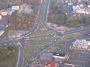
, which was turned into an at-grade intersection in 2006. The Marlton Circle
at Route 70, which was modified in 1974 to allow Route 73 to pass through the circle, was replaced with an interchange completed in 2011.
(Black Horse Pike
) in Folsom
, Atlantic County
, heading to the northwest on Blue Anchor Road, a two-lane undivided county-maintained road signed as County Route 561 Spur. This portion of the route is officially considered a part of Route 73 but is not signed as such. The road runs through forested areas of the Pine Barrens
with some homes and farms, coming to a crossroads with Route 54. Following this intersection, the road continues northwest as Mays Landing Road, crossing over a Conrail Shared Assets Operations
railroad line. It enters a small corner of Hammonton
before it crosses into Winslow Township
in Camden County
. Here, Route 73 crosses over a Southern Railroad of New Jersey
railroad line and intersects County Route 725. From this point, the road heads north to a partial interchange with the Atlantic City Expressway
that has access from southbound Route 73 to the eastbound Atlantic City Expressway and from the westbound Atlantic City Expressway to northbound Route 73.
, although County Route 561 Spur is still signed along the route. It heads to the north as a four-lane undivided road, passing through wooded areas with some residences and businesses and crosses CR 723. The route continues to an intersection with CR 561
, where it briefly widens into a four-lane divided highway
. At this junction, CR 561 Spur ends and Route 73 forms a concurrency
with County Route 561. The road intersects CR 722 and CR 721, becoming Camden Road at the latter junction. It heads north through more rural areas, meeting CR 720. County Route 561C, a former segment of County Route 561, splits from Route 73 by heading north through the community of Cedar Brook while Route 73 and CR 561 bypass the community to the east, crossing under a Conrail Shared Assets Operations railroad line.
North of Cedar Brook, the route traverses CR 536
, becoming Cedarbrook Road. It intersects CR 680 and CR 711 before widening into a divided highway prior to a junction where CR 712 heads northeast and CR 561 splits from Route 73 by heading north on Cedarbrook Road. Past this intersection, Route 73 becomes an unnamed road and encounters CR 710 at a four-way intersection. A short distance later, the route enters Waterford Township
and comes to a modified cloverleaf interchange
with U.S. Route 30
(White Horse Pike) and County Route 536 Spur.
 Following US 30, Route 73 passes through a small corner of Berlin Boro
before it goes under New Jersey Transit
’s Atlantic City Line
near the Atco station
. At the railroad crossing, the route enters Berlin Township
and meets CR 534
at a crossroad. After the intersection with this route, the road proceeds back into Berlin Boro, where the route runs through a mix of residences and businesses. Route 73 widens to a six-lane highway and comes to the former Berlin Circle
, where it meets both CR 689 and CR 708. From here, the road turns north and reenters Berlin Township as a four-lane divided highway, continuing through developed areas and intersecting CR 692. Prior to the junction with CR 693, the route enters Voorhees Township
, where it encounters CR 675.
At the intersection with CR 671, Route 73 comes into Evesham Township
, Burlington County
. In Evesham, it heads to a junction with CR 544
before coming to Marlton
, where it passes by The Promenade at Sagemore
before turning northwest at CR 607. The route intersects CR 600 and CR 620 before meeting Route 70 at an interchange that was formerly the Marlton Circle
.
 Subsequent to the Marlton Circle, Route 73 continues through suburban commercial areas, heading into Mount Laurel Township
. The route comes to an intersection with CR 616, where it turns to the northwest. A short distance later, the road has an access ramp to the New Jersey Turnpike
. Following this interchange, Route 73 widens into a six-lane divided highway and encounters CR 673 before coming to a cloverleaf interchange with Interstate 295
. Between the New Jersey Turnpike and Interstate 295, Route 73 serves as a part of a main route from North Jersey
and New York City
to Philadelphia as motorists use the turnpike to get to and from points north and I-295 south to access I-76
, which provides access to both the Walt Whitman Bridge
and Ben Franklin Bridge to Philadelphia. From the I-295 interchange, the route goes into Maple Shade Township
. Route 73 comes to two exits for Route 38 and Route 41 within a short distance of each other. After Route 41, the road intersects County Route 610 and bypasses the center of Maple Shade to the east as a four-lane divided highway. The route interchanges with CR 537
and runs under a Conrail Shared Assets Operations railroad line before turning northwest and paralleling the North Branch of the Pennsauken Creek
, meeting CR 609.
Route 73 enters Cinnaminson Township
, where the Route 90 freeway splits from the road before crossing over the South Branch of the Pennsauken Creek into Pennsauken Township
, Camden County. In Pennsauken, the route has exits with County Route 644 and U.S. Route 130
. Route 73 briefly enters Cinnaminson Township, Burlington County again before entering Palmyra
at the bridge over the Pennsauken Creek. In Palmyra, the road has an interchange with County Route 543
before running under New Jersey Transit’s River Line
. The route comes to the intersection with Temple Boulevard, where it becomes maintained by the Burlington County Bridge Commission
and comes to the northbound toll plaza for the Tacony-Palmyra Bridge
. A short distance later, the road traverses the Delaware River
on the three-lane Tacony-Palmyra Bridge, where it continues into Philadelphia, Pennsylvania
as Pennsylvania Route 73
. The Tacony-Palmyra Bridge is a drawbridge
designed by Ralph Modjeski
, who also engineered the Ben Franklin Bridge and the Manhattan Bridge
, that opened to traffic in 1929, replacing a ferry service across the Delaware River.
Route 73 serves as a main road in South Jersey
that helps provide access between the Philadelphia area and the southern part of the Jersey Shore
as well as connections to several local roads. It has been rated one of the worst roads in the state in terms of traffic, accidents, and driver aggression.
, a spur of Route 41 called Route S41 was legislated to run fron the Tacony-Palmyra Bridge south to Berlin along what is today Route 73. A southern extension of Route S41 called Route S41A was proposed to run from Berlin south to Route 42 (now U.S. Route 322) in Folsom in 1938. In the 1953 New Jersey state highway renumbering
, Route S41 and Route S41A were renumbered to Route 73 in order to match Pennsylvania Route 73. With the establishment of the 500-series county routes in 1952, the current alignment of Route 73 between Berlin and Blue Anchor became a part of County Route 561 while it became County Route 561 Spur between Blue Anchor and Folsom. By 1969, Route 73 was designated south of Berlin along County Route 561 and County Route 561 Spur to the Atlantic City Expressway. By the 2000s, Route 73 was extended south along with County Route 561 Spur from the Atlantic City Expressway to U.S. Route 322.
Over the years, several traffic circle
s have been modified or replaced along Route 73. The Marlton Circle at Route 70 in Marlton was modified in 1974 to allow Route 73 to run directly straight through the circle. This circle became known for traffic backups and was replaced with an interchange. Construction on this interchange, which cost $31 million, began in April 2009. In May 2010, the circle was eliminated with a temporary at-grade intersection constructed while the Route 73 bridge over Route 70 was being built. The interchange was completed in June 2011. A traffic circle that existed at the intersection of Route 38 and Route 41 in Maple Shade Township was removed by the 1990s and replaced by the current set of interchanges. In addition, the Berlin Circle in Berlin was replaced by an at-grade intersection between August 2005 and September 2006 at a cost of $73 million.
State highway
State highway, state road or state route can refer to one of three related concepts, two of them related to a state or provincial government in a country that is divided into states or provinces :#A...
in the southern part of the U.S. state
U.S. state
A U.S. state is any one of the 50 federated states of the United States of America that share sovereignty with the federal government. Because of this shared sovereignty, an American is a citizen both of the federal entity and of his or her state of domicile. Four states use the official title of...
of New Jersey
New Jersey
New Jersey is a state in the Northeastern and Middle Atlantic regions of the United States. , its population was 8,791,894. It is bordered on the north and east by the state of New York, on the southeast and south by the Atlantic Ocean, on the west by Pennsylvania and on the southwest by Delaware...
. It runs 34.64 mi (55.75 km) as an outer bypass of the Camden
Camden, New Jersey
The city of Camden is the county seat of Camden County, New Jersey. It is located across the Delaware River from Philadelphia, Pennsylvania. As of the 2010 United States Census, the city had a total population of 77,344...
area from an intersection with U.S. Route 322
U.S. Route 322 in New Jersey
U.S. Route 322 is a U.S. highway running from Cleveland, Ohio east to Atlantic City, New Jersey. The easternmost segment of the route in New Jersey runs from the Commodore Barry Bridge over the Delaware River in Logan Township, Glocuester County, where it continues into Chester, Pennsylvania,...
in Folsom
Folsom, New Jersey
Folsom is a borough in Atlantic County, New Jersey, United States. As of the United States 2010 Census, the borough population was 1,885.Folsom was incorporated as a borough by an Act of the New Jersey Legislature on May 23, 1906, from portions of Buena Vista Township.New Jersey Monthly magazine...
, Atlantic County
Atlantic County, New Jersey
-National protected areas:* Edwin B. Forsythe National Wildlife Refuge * Great Egg Harbor Scenic and Recreational River -Demographics:...
to the Tacony-Palmyra Bridge
Tacony-Palmyra Bridge
The Tacony–Palmyra Bridge is a combination steel arch, double-leaf bascule bridge across the Delaware River, connecting New Jersey Route 73 in Palmyra, New Jersey and Pennsylvania Route 73 in the Tacony section of Philadelphia. The bridge has a total length of 3,659 feet and spans 2,324 feet . It...
in Palmyra
Palmyra, New Jersey
Palmyra is a Borough in Burlington County, New Jersey, United States. As of the 2000 United States Census, the borough population was 7,091.Palmyra was originally incorporated as a township by an Act of the New Jersey Legislature on April 19, 1894, from portions of Cinnaminson Township and Riverton...
, Burlington County
Burlington County, New Jersey
There were 154,371 households out of which 34.30% had children under the age of 18 living with them, 57.70% were married couples living together, 10.90% had a female householder with no husband present, and 27.70% were non-families. 22.90% of all households were made up of individuals and 8.50% had...
, where it continues into Philadelphia, Pennsylvania
Pennsylvania
The Commonwealth of Pennsylvania is a U.S. state that is located in the Northeastern and Mid-Atlantic regions of the United States. The state borders Delaware and Maryland to the south, West Virginia to the southwest, Ohio to the west, New York and Ontario, Canada, to the north, and New Jersey to...
as Pennsylvania Route 73
Pennsylvania Route 73
Pennsylvania Route 73 is a 62.51 miles long east–west state highway in southeastern Pennsylvania. It runs from Pennsylvania Route 61 in Leesport to the New Jersey state line on the Tacony-Palmyra Bridge in Philadelphia, where it continues as New Jersey Route 73.Predating the Interstate...
. South of the interchange with the Atlantic City Expressway
Atlantic City Expressway
The Atlantic City Expressway is a , controlled-access toll road in New Jersey, managed and operated by the South Jersey Transportation Authority...
in Winslow Township
Winslow Township, New Jersey
As of the census of 2010, there were 39,599 people, 13,567 households, and 9,662 families residing in the township. The population density was 599.9 people per square mile . There were 12,413 housing units at an average density of 215.1 per square mile...
, Camden County
Camden County, New Jersey
-Demographics:As of the 2010 Census the population of Camden County was 60.28% Non-Hispanic white, 18.45% Non-Hispanic black, 1.12% Hispanic blacks, 0.17% Non-Hispanic Native American, 0.15% Hispanic Native Americans, 5.07% Non-Hispanic Asian, and 0.14% non-Hispanics reporting some other race...
, Route 73 is a two-lane undivided county-maintained road and is signed as County Route 561 Spur, a spur of County Route 561
County Route 561 (New Jersey)
County Route 561, abbreviated CR 561, is a county highway in the U.S. state of New Jersey. The highway extends from New York Road in Galloway Township to Federal Street , Camden.-Atlantic County:...
(CR 561). North of the Atlantic City Expressway, the route is maintained by the New Jersey Department of Transportation
New Jersey Department of Transportation
The New Jersey Department of Transportation is the agency responsible for transportation issues and policy in New Jersey. It is headed by the Commissioner of Transportation...
and is mostly four lanes, with the portion north of the County Route 561 concurrency
Concurrency (road)
A concurrency, overlap, or coincidence in a road network is an instance of one physical road bearing two or more different highway, motorway, or other route numbers...
a divided highway
Divided Highway
Divided Highway is a compilation album by American rock band The Doobie Brothers, released in 2003. . All tracks are taken from the albums Cycles and Brotherhood .-Track listing:...
. North of the U.S. Route 30
U.S. Route 30 in New Jersey
U.S. Route 30 is a U.S. highway running from Astoria, Oregon east to Atlantic City, New Jersey. In the U.S. state of New Jersey, US 30 runs from the Benjamin Franklin Bridge at the Delaware River in Camden, Camden County while concurrent with Interstate 676 southeast to Virginia...
(US 30) interchange near Berlin
Berlin, New Jersey
Berlin is a Borough in Camden County, New Jersey, United States. As of the 2010 United States Census, the borough population was 7,588.Berlin was incorporated as a borough on March 29, 1927, from portions of Berlin Township, based on the results of a referendum held on April 26,...
, Route 73 runs through suburban areas of the Delaware Valley
Delaware Valley
The Delaware Valley is a term used to refer to the valley where the Delaware River flows, along with the surrounding communities. This includes the metropolitan area centered on the city of Philadelphia. Such educational institutions as Delaware Valley Regional High School in Alexandria Township...
, intersecting Route 70 in Marlton
Marlton, New Jersey
Marlton is a census-designated place and unincorporated area located within Evesham Township in Burlington County, New Jersey. As of the United States 2000 Census, the population of Marlton was 10,260.-History:...
, the New Jersey Turnpike
New Jersey Turnpike
The New Jersey Turnpike is a toll road in New Jersey, maintained by the New Jersey Turnpike Authority. According to the International Bridge, Tunnel and Turnpike Association, the Turnpike is the nation's sixth-busiest toll road and is among one of the most heavily traveled highways in the United...
and Interstate 295
Interstate 295 (Delaware-New Jersey)
Interstate 295 in New Jersey and Delaware is an auxiliary Interstate Highway, designated as a bypass around Philadelphia, Pennsylvania. The route begins at a junction with Interstate 95 south of Wilmington, Delaware, and runs to another junction with I-95 north of Trenton, New Jersey...
(I-295) in Mount Laurel Township
Mount Laurel Township, New Jersey
Mount Laurel Township is a Township in Burlington County, New Jersey, United States, and is an edge city "suburb" of Philadelphia. As of the 2000 United States Census, the township population was 40,221...
, Route 38 and Route 41 in Maple Shade Township
Maple Shade Township, New Jersey
Maple Shade Township is a township in Burlington County, New Jersey, United States. As of the United States 2000 Census, the township population was 19,079....
, Route 90 in Cinnaminson Township
Cinnaminson Township, New Jersey
Cinnaminson includes within its boundaries the confluence point of longitude 75 degrees west and latitude 40 degrees north, one of only four such confluence points in New Jersey...
, and U.S. Route 130
U.S. Route 130
U.S. Route 130 is a north–south U.S. Highway completely within the state of New Jersey. It runs from Interstate 295 and US 40 at Deepwater in Pennsville Township, Salem County, where the road continues east as Route 49, north to US 1 in North Brunswick Township, Middlesex County, where...
in Pennsauken Township
Pennsauken Township, New Jersey
Pennsauken Township is a township in Camden County, New Jersey, USA, and a suburb of Philadelphia. As of the 2010 census, the township population was 35,885....
.
What is today Route 73 between the Tacony-Palmyra Bridge and Berlin was legislated as Route S41 in 1927, a spur of Route 41. An extension of this spur called Route S41A was designated in 1938 to continue south from Berlin to Route 42 (now U.S. Route 322) in Folsom. In 1953, both these routes became Route 73 in order to match Pennsylvania Route 73. The portion of Route 73 between Berlin and the Atlantic City Expressway became a state highway by 1969. By the 2000s, Route 73 was extended south along County Route 561 Spur to U.S. Route 322. Several traffic circles along Route 73 have been modified or replaced over time. Among these was the Berlin Circle
Berlin Circle (traffic circle)
The Berlin Circle was a traffic circle in Berlin Township, New Jersey, United States located at the intersection of Route 73, Berlin-Cross Keys Road and Walker Avenue, and which also received traffic from nearby U.S. Route 30, and County Route 561. The New Jersey Department of Transportation ...
, which was turned into an at-grade intersection in 2006. The Marlton Circle
Marlton Circle
The Marlton Circle was a traffic circle in the Marlton section of Evesham Township, New Jersey, located at the intersection of Route 70 and Route 73...
at Route 70, which was modified in 1974 to allow Route 73 to pass through the circle, was replaced with an interchange completed in 2011.
US 322 to Atlantic City Expressway
Route 73 begins at an intersection with U.S. Route 322U.S. Route 322 in New Jersey
U.S. Route 322 is a U.S. highway running from Cleveland, Ohio east to Atlantic City, New Jersey. The easternmost segment of the route in New Jersey runs from the Commodore Barry Bridge over the Delaware River in Logan Township, Glocuester County, where it continues into Chester, Pennsylvania,...
(Black Horse Pike
Black Horse Pike
The Black Horse Pike is a designation used for a number of different roadways that had been part of a historic route connecting the Camden area to the area of Atlantic City, New Jersey. Roadways now bearing the Black Horse Pike designation include portions of New Jersey Route 168, New Jersey Route...
) in Folsom
Folsom, New Jersey
Folsom is a borough in Atlantic County, New Jersey, United States. As of the United States 2010 Census, the borough population was 1,885.Folsom was incorporated as a borough by an Act of the New Jersey Legislature on May 23, 1906, from portions of Buena Vista Township.New Jersey Monthly magazine...
, Atlantic County
Atlantic County, New Jersey
-National protected areas:* Edwin B. Forsythe National Wildlife Refuge * Great Egg Harbor Scenic and Recreational River -Demographics:...
, heading to the northwest on Blue Anchor Road, a two-lane undivided county-maintained road signed as County Route 561 Spur. This portion of the route is officially considered a part of Route 73 but is not signed as such. The road runs through forested areas of the Pine Barrens
Pine Barrens (New Jersey)
The Pine Barrens, also known as the Pinelands, is a heavily forested area of coastal plain stretching across southern New Jersey. The name "pine barrens" refers to the area's sandy, acidic, nutrient-poor soil, to which the crops originally imported by European settlers didn't take well...
with some homes and farms, coming to a crossroads with Route 54. Following this intersection, the road continues northwest as Mays Landing Road, crossing over a Conrail Shared Assets Operations
Conrail Shared Assets Operations
Conrail Shared Assets Operations is an American railroad company. It operates three networks—the North Jersey, South Jersey/Philadelphia, and Detroit Shared Assets Areas, where it serves as a local carrier and switching company for CSX Transportation and the Norfolk Southern Railway...
railroad line. It enters a small corner of Hammonton
Hammonton, New Jersey
Hammonton is a town in Atlantic County, New Jersey, United States. As of the 2010 United States Census, the town population was 14,791. It is located directly between Philadelphia and the resort town of Atlantic City, along a former route of the Pennsylvania Railroad currently used by New Jersey...
before it crosses into Winslow Township
Winslow Township, New Jersey
As of the census of 2010, there were 39,599 people, 13,567 households, and 9,662 families residing in the township. The population density was 599.9 people per square mile . There were 12,413 housing units at an average density of 215.1 per square mile...
in Camden County
Camden County, New Jersey
-Demographics:As of the 2010 Census the population of Camden County was 60.28% Non-Hispanic white, 18.45% Non-Hispanic black, 1.12% Hispanic blacks, 0.17% Non-Hispanic Native American, 0.15% Hispanic Native Americans, 5.07% Non-Hispanic Asian, and 0.14% non-Hispanics reporting some other race...
. Here, Route 73 crosses over a Southern Railroad of New Jersey
Southern Railroad of New Jersey
The Southern Railroad of New Jersey is a small short-line railroad company based in Winslow, New Jersey. Trains operate between Winslow Junction and Pleasantville and between Winslow Junction and Vineland...
railroad line and intersects County Route 725. From this point, the road heads north to a partial interchange with the Atlantic City Expressway
Atlantic City Expressway
The Atlantic City Expressway is a , controlled-access toll road in New Jersey, managed and operated by the South Jersey Transportation Authority...
that has access from southbound Route 73 to the eastbound Atlantic City Expressway and from the westbound Atlantic City Expressway to northbound Route 73.
Atlantic City Expressway to NJ 70
After the Atlantic City Expressway, Route 73 becomes officially signed and maintained by the New Jersey Department of TransportationNew Jersey Department of Transportation
The New Jersey Department of Transportation is the agency responsible for transportation issues and policy in New Jersey. It is headed by the Commissioner of Transportation...
, although County Route 561 Spur is still signed along the route. It heads to the north as a four-lane undivided road, passing through wooded areas with some residences and businesses and crosses CR 723. The route continues to an intersection with CR 561
County Route 561 (New Jersey)
County Route 561, abbreviated CR 561, is a county highway in the U.S. state of New Jersey. The highway extends from New York Road in Galloway Township to Federal Street , Camden.-Atlantic County:...
, where it briefly widens into a four-lane divided highway
Divided Highway
Divided Highway is a compilation album by American rock band The Doobie Brothers, released in 2003. . All tracks are taken from the albums Cycles and Brotherhood .-Track listing:...
. At this junction, CR 561 Spur ends and Route 73 forms a concurrency
Concurrency (road)
A concurrency, overlap, or coincidence in a road network is an instance of one physical road bearing two or more different highway, motorway, or other route numbers...
with County Route 561. The road intersects CR 722 and CR 721, becoming Camden Road at the latter junction. It heads north through more rural areas, meeting CR 720. County Route 561C, a former segment of County Route 561, splits from Route 73 by heading north through the community of Cedar Brook while Route 73 and CR 561 bypass the community to the east, crossing under a Conrail Shared Assets Operations railroad line.
North of Cedar Brook, the route traverses CR 536
County Route 536 (New Jersey)
County Route 536, abbreviated CR 536, is a county highway in the U.S. state of New Jersey. The highway extends from the Commodore Barry Bridge crossing the Delaware River at Chester at the Pennsylvania state line and Logan Township, to U.S...
, becoming Cedarbrook Road. It intersects CR 680 and CR 711 before widening into a divided highway prior to a junction where CR 712 heads northeast and CR 561 splits from Route 73 by heading north on Cedarbrook Road. Past this intersection, Route 73 becomes an unnamed road and encounters CR 710 at a four-way intersection. A short distance later, the route enters Waterford Township
Waterford Township, New Jersey
Waterford Township is a Township in Camden County, New Jersey, United States. As of the 2000 United States Census, the township population was 10,494....
and comes to a modified cloverleaf interchange
Cloverleaf interchange
A cloverleaf interchange is a two-level interchange in which left turns, reverse direction in left-driving regions, are handled by ramp roads...
with U.S. Route 30
U.S. Route 30 in New Jersey
U.S. Route 30 is a U.S. highway running from Astoria, Oregon east to Atlantic City, New Jersey. In the U.S. state of New Jersey, US 30 runs from the Benjamin Franklin Bridge at the Delaware River in Camden, Camden County while concurrent with Interstate 676 southeast to Virginia...
(White Horse Pike) and County Route 536 Spur.
Berlin, New Jersey
Berlin is a Borough in Camden County, New Jersey, United States. As of the 2010 United States Census, the borough population was 7,588.Berlin was incorporated as a borough on March 29, 1927, from portions of Berlin Township, based on the results of a referendum held on April 26,...
before it goes under New Jersey Transit
New Jersey Transit
The New Jersey Transit Corporation is a statewide public transportation system serving the United States state of New Jersey, and New York, Orange, and Rockland counties in New York State...
’s Atlantic City Line
Atlantic City Line
The Atlantic City Line is a rail line operated by New Jersey Transit between Philadelphia, Pennsylvania and Atlantic City, New Jersey, operating along the corridor of the White Horse Pike. It runs over trackage that was controlled by both the Pennsylvania Railroad and the Pennsylvania-Reading...
near the Atco station
Atco (NJT station)
Atco is a New Jersey Transit train station in the Atco section of Waterford Township, New Jersey on the Atlantic City Line. Its Amtrak station code is ATO. Eastbound service is offered to Atlantic City and Westbound service is offered to Philadelphia...
. At the railroad crossing, the route enters Berlin Township
Berlin Township, New Jersey
Berlin Township is a Township in Camden County, New Jersey, United States. As of the 2010 United States Census, the township population was 5,357.Berlin was incorporated as a township on April 11, 1910, from portions of Waterford Township...
and meets CR 534
County Route 534 (New Jersey)
County Route 534, abbreviated CR 534, is a county highway in the U.S. state of New Jersey. The highway extends from Route 47 in Deptford Township to Medford-Indian Mills Road in Shamong Township.-Gloucester County:...
at a crossroad. After the intersection with this route, the road proceeds back into Berlin Boro, where the route runs through a mix of residences and businesses. Route 73 widens to a six-lane highway and comes to the former Berlin Circle
Berlin Circle (traffic circle)
The Berlin Circle was a traffic circle in Berlin Township, New Jersey, United States located at the intersection of Route 73, Berlin-Cross Keys Road and Walker Avenue, and which also received traffic from nearby U.S. Route 30, and County Route 561. The New Jersey Department of Transportation ...
, where it meets both CR 689 and CR 708. From here, the road turns north and reenters Berlin Township as a four-lane divided highway, continuing through developed areas and intersecting CR 692. Prior to the junction with CR 693, the route enters Voorhees Township
Voorhees Township, New Jersey
-Demographics:As of the census of 2000, there were 28,126 people, 10,489 households, and 7,069 families residing in the township. The population density was 2,424.0 people per square mile . There were 11,084 housing units at an average density of 955.2 per square mile...
, where it encounters CR 675.
At the intersection with CR 671, Route 73 comes into Evesham Township
Evesham Township, New Jersey
Evesham Township is a township in Burlington County, New Jersey, United States. The township population was 45,538 as of the 2010 United States Census....
, Burlington County
Burlington County, New Jersey
There were 154,371 households out of which 34.30% had children under the age of 18 living with them, 57.70% were married couples living together, 10.90% had a female householder with no husband present, and 27.70% were non-families. 22.90% of all households were made up of individuals and 8.50% had...
. In Evesham, it heads to a junction with CR 544
County Route 544 (New Jersey)
County Route 544, abbreviated CR 544, is a county highway in the U.S. state of New Jersey. The highway extends from Cooper Street in Deptford Township to Taunton Boulevard in Medford Township.-Gloucester County:...
before coming to Marlton
Marlton, New Jersey
Marlton is a census-designated place and unincorporated area located within Evesham Township in Burlington County, New Jersey. As of the United States 2000 Census, the population of Marlton was 10,260.-History:...
, where it passes by The Promenade at Sagemore
The Promenade at Sagemore
The Promenade at Sagemore is a large regional shopping mall located in the Marlton section of Evesham Township, in Burlington County, New Jersey, United States, leased by Kravco Simon. Opened in 2001, The Promenade is an open-air lifestyle center with high-end stores and a selection of casual and...
before turning northwest at CR 607. The route intersects CR 600 and CR 620 before meeting Route 70 at an interchange that was formerly the Marlton Circle
Marlton Circle
The Marlton Circle was a traffic circle in the Marlton section of Evesham Township, New Jersey, located at the intersection of Route 70 and Route 73...
.
NJ 70 to Tacony-Palmyra Bridge
Mount Laurel Township, New Jersey
Mount Laurel Township is a Township in Burlington County, New Jersey, United States, and is an edge city "suburb" of Philadelphia. As of the 2000 United States Census, the township population was 40,221...
. The route comes to an intersection with CR 616, where it turns to the northwest. A short distance later, the road has an access ramp to the New Jersey Turnpike
New Jersey Turnpike
The New Jersey Turnpike is a toll road in New Jersey, maintained by the New Jersey Turnpike Authority. According to the International Bridge, Tunnel and Turnpike Association, the Turnpike is the nation's sixth-busiest toll road and is among one of the most heavily traveled highways in the United...
. Following this interchange, Route 73 widens into a six-lane divided highway and encounters CR 673 before coming to a cloverleaf interchange with Interstate 295
Interstate 295 (Delaware-New Jersey)
Interstate 295 in New Jersey and Delaware is an auxiliary Interstate Highway, designated as a bypass around Philadelphia, Pennsylvania. The route begins at a junction with Interstate 95 south of Wilmington, Delaware, and runs to another junction with I-95 north of Trenton, New Jersey...
. Between the New Jersey Turnpike and Interstate 295, Route 73 serves as a part of a main route from North Jersey
North Jersey
North Jersey is a colloquial term, with no precise consensus definition, for the northern portion of the U.S. state of New Jersey. A straightforward, noncolloquial term for the region is northern New Jersey.- Two-portion approaches :...
and New York City
New York City
New York is the most populous city in the United States and the center of the New York Metropolitan Area, one of the most populous metropolitan areas in the world. New York exerts a significant impact upon global commerce, finance, media, art, fashion, research, technology, education, and...
to Philadelphia as motorists use the turnpike to get to and from points north and I-295 south to access I-76
Interstate 76 (east)
Interstate 76 is an Interstate Highway in the United States, running 435 miles from an interchange with Interstate 71 west of Akron, Ohio, east to Interstate 295 near Camden, New Jersey....
, which provides access to both the Walt Whitman Bridge
Walt Whitman Bridge
The Walt Whitman Bridge is a green-colored single-level suspension bridge spanning the Delaware River from Philadelphia to Gloucester City, New Jersey. Named after the poet Walt Whitman, who resided in nearby Camden toward the end of his life, the Walt Whitman Bridge is one of the larger bridges...
and Ben Franklin Bridge to Philadelphia. From the I-295 interchange, the route goes into Maple Shade Township
Maple Shade Township, New Jersey
Maple Shade Township is a township in Burlington County, New Jersey, United States. As of the United States 2000 Census, the township population was 19,079....
. Route 73 comes to two exits for Route 38 and Route 41 within a short distance of each other. After Route 41, the road intersects County Route 610 and bypasses the center of Maple Shade to the east as a four-lane divided highway. The route interchanges with CR 537
County Route 537 (New Jersey)
County Route 537, abbreviated CR 537, is a county highway in the U.S. state of New Jersey. The highway extends from Delaware Avenue in Camden to Myrtle Avenue in Long Branch.-Camden County:...
and runs under a Conrail Shared Assets Operations railroad line before turning northwest and paralleling the North Branch of the Pennsauken Creek
Pennsauken Creek
Pennsauken Creek is a tributary of the Delaware River in Burlington and Camden counties, New Jersey in the United States.Pennsauken Creek drains of southwestern Burlington County and northern Camden County and joins the Delaware River near Palmyra....
, meeting CR 609.
Route 73 enters Cinnaminson Township
Cinnaminson Township, New Jersey
Cinnaminson includes within its boundaries the confluence point of longitude 75 degrees west and latitude 40 degrees north, one of only four such confluence points in New Jersey...
, where the Route 90 freeway splits from the road before crossing over the South Branch of the Pennsauken Creek into Pennsauken Township
Pennsauken Township, New Jersey
Pennsauken Township is a township in Camden County, New Jersey, USA, and a suburb of Philadelphia. As of the 2010 census, the township population was 35,885....
, Camden County. In Pennsauken, the route has exits with County Route 644 and U.S. Route 130
U.S. Route 130
U.S. Route 130 is a north–south U.S. Highway completely within the state of New Jersey. It runs from Interstate 295 and US 40 at Deepwater in Pennsville Township, Salem County, where the road continues east as Route 49, north to US 1 in North Brunswick Township, Middlesex County, where...
. Route 73 briefly enters Cinnaminson Township, Burlington County again before entering Palmyra
Palmyra, New Jersey
Palmyra is a Borough in Burlington County, New Jersey, United States. As of the 2000 United States Census, the borough population was 7,091.Palmyra was originally incorporated as a township by an Act of the New Jersey Legislature on April 19, 1894, from portions of Cinnaminson Township and Riverton...
at the bridge over the Pennsauken Creek. In Palmyra, the road has an interchange with County Route 543
County Route 543 (New Jersey)
County Route 543, abbreviated CR 543, is a county highway in the U.S. state of New Jersey. The highway extends from Federal Street in Camden to Wrightstown-Georgetown Road in Mansfield Township.-Camden County:...
before running under New Jersey Transit’s River Line
River Line (New Jersey Transit)
The River Line is a diesel light rail system in New Jersey, United States, that connects the cities of Camden and Trenton, New Jersey's capital. It is operated for New Jersey Transit by the Southern New Jersey Rail Group , which originally included Bechtel Group and Bombardier...
. The route comes to the intersection with Temple Boulevard, where it becomes maintained by the Burlington County Bridge Commission
Burlington County Bridge Commission
The Burlington County Bridge Commission is a public agency responsible for the operation and maintenance of several bridges in Burlington County, New Jersey across the Delaware River. It now manages eight bridges, including the Tacony-Palmyra Bridge, the Burlington-Bristol Bridge, and the...
and comes to the northbound toll plaza for the Tacony-Palmyra Bridge
Tacony-Palmyra Bridge
The Tacony–Palmyra Bridge is a combination steel arch, double-leaf bascule bridge across the Delaware River, connecting New Jersey Route 73 in Palmyra, New Jersey and Pennsylvania Route 73 in the Tacony section of Philadelphia. The bridge has a total length of 3,659 feet and spans 2,324 feet . It...
. A short distance later, the road traverses the Delaware River
Delaware River
The Delaware River is a major river on the Atlantic coast of the United States.A Dutch expedition led by Henry Hudson in 1609 first mapped the river. The river was christened the South River in the New Netherland colony that followed, in contrast to the North River, as the Hudson River was then...
on the three-lane Tacony-Palmyra Bridge, where it continues into Philadelphia, Pennsylvania
Pennsylvania
The Commonwealth of Pennsylvania is a U.S. state that is located in the Northeastern and Mid-Atlantic regions of the United States. The state borders Delaware and Maryland to the south, West Virginia to the southwest, Ohio to the west, New York and Ontario, Canada, to the north, and New Jersey to...
as Pennsylvania Route 73
Pennsylvania Route 73
Pennsylvania Route 73 is a 62.51 miles long east–west state highway in southeastern Pennsylvania. It runs from Pennsylvania Route 61 in Leesport to the New Jersey state line on the Tacony-Palmyra Bridge in Philadelphia, where it continues as New Jersey Route 73.Predating the Interstate...
. The Tacony-Palmyra Bridge is a drawbridge
Drawbridge
A drawbridge is a type of movable bridge typically associated with the entrance of a castle surrounded by a moat. The term is often used to describe all different types of movable bridges, like bascule bridges and lift bridges.-Castle drawbridges:...
designed by Ralph Modjeski
Ralph Modjeski
Ralph Modjeski was a Polish-born American civil engineer who achieved prominence as a pre-eminent bridge designer in the United States.-Life:...
, who also engineered the Ben Franklin Bridge and the Manhattan Bridge
Manhattan Bridge
The Manhattan Bridge is a suspension bridge that crosses the East River in New York City, connecting Lower Manhattan with Brooklyn . It was the last of the three suspension bridges built across the lower East River, following the Brooklyn and the Williamsburg bridges...
, that opened to traffic in 1929, replacing a ferry service across the Delaware River.
Route 73 serves as a main road in South Jersey
South Jersey
South Jersey comprises the southern portions of the U.S. state of New Jersey between the lower Delaware River and the Atlantic Ocean. The designation is a colloquial one, reflecting not only geographical but perceived cultural differences from the northern part of the state, with no official...
that helps provide access between the Philadelphia area and the southern part of the Jersey Shore
Jersey Shore
The Jersey Shore is a term used to refer to both the Atlantic coast of the U.S. state of New Jersey and the adjacent resort and residential communities. . The New Jersey State Department of Tourism considers the Shore Region, Greater Atlantic City, and the Southern Shore to be distinct, each having...
as well as connections to several local roads. It has been rated one of the worst roads in the state in terms of traffic, accidents, and driver aggression.
History
In the 1927 New Jersey state highway renumbering1927 New Jersey state highway renumbering
In 1927, New Jersey's state highways were renumbered. The old system, which had been defined in sequence by the legislature, was growing badly, as several routes shared the same number, and many unnumbered state highways had been defined...
, a spur of Route 41 called Route S41 was legislated to run fron the Tacony-Palmyra Bridge south to Berlin along what is today Route 73. A southern extension of Route S41 called Route S41A was proposed to run from Berlin south to Route 42 (now U.S. Route 322) in Folsom in 1938. In the 1953 New Jersey state highway renumbering
1953 New Jersey state highway renumbering
On January 1, 1953, the New Jersey Department of Transportation renumbered many of the State Routes. A few rules were followed in deciding what to renumber:...
, Route S41 and Route S41A were renumbered to Route 73 in order to match Pennsylvania Route 73. With the establishment of the 500-series county routes in 1952, the current alignment of Route 73 between Berlin and Blue Anchor became a part of County Route 561 while it became County Route 561 Spur between Blue Anchor and Folsom. By 1969, Route 73 was designated south of Berlin along County Route 561 and County Route 561 Spur to the Atlantic City Expressway. By the 2000s, Route 73 was extended south along with County Route 561 Spur from the Atlantic City Expressway to U.S. Route 322.
Over the years, several traffic circle
Traffic circle
A traffic circle or rotary is a type of circular intersection in which traffic must travel in one direction around a central island. In some countries, traffic entering the circle has the right-of-way and drivers in the circle must yield. In many other countries, traffic entering the circle must...
s have been modified or replaced along Route 73. The Marlton Circle at Route 70 in Marlton was modified in 1974 to allow Route 73 to run directly straight through the circle. This circle became known for traffic backups and was replaced with an interchange. Construction on this interchange, which cost $31 million, began in April 2009. In May 2010, the circle was eliminated with a temporary at-grade intersection constructed while the Route 73 bridge over Route 70 was being built. The interchange was completed in June 2011. A traffic circle that existed at the intersection of Route 38 and Route 41 in Maple Shade Township was removed by the 1990s and replaced by the current set of interchanges. In addition, the Berlin Circle in Berlin was replaced by an at-grade intersection between August 2005 and September 2006 at a cost of $73 million.