
.gif)
Route 66 (New Jersey)
Encyclopedia
Route 66 is a state highway
located in Monmouth County
, New Jersey
, United States
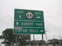
. It runs 3.62 mi (5.83 km) between Route 33 in Tinton Falls
and Route 35 at County Route 16 on the border of Ocean Township
and Neptune Township
, just to the west of Asbury Park
. The route serves as an important connector between the Garden State Parkway
to the west and Route 18 and Asbury Park to the east. It runs concurrent with County Route 16 from Brown/Wayside Roads to the eastern terminus at Route 35. Route 66, which varies from a two-lane undivided road to a four-lane divided highway
, passes through commercial areas for most of its length with some wooded areas. The route was created in 1953, replacing what had been Route 33-35 Link. There is currently a proposal to widen the two-lane portion between Jumping Brook Road and Wayside Road in order to better handle the traffic that uses this road.
, heading to the northeast as a 40 mph (64.4 km/h) two-lane road. A short distance past Route 33, it comes to an interchange with the Garden State Parkway
, where the road becomes a three lane undivided road with one eastbound lane and two westbound lanes. Past this interchange, the route becomes a 50 mph (80.5 km/h) road that heads into commercial areas, where it widens into a four-lane divided highway
that passes by the Jersey Shore Premium Outlets before heading into Neptune Township
. After the intersection with Jumping Brook Road, the divided highway ends and Route 66 becomes a two-lane undivided road. The route heads through a patch of woods before passing more businesses and coming to an intersection with County Route 16 (Asbury Avenue). Here, the road becomes a four-lane divided highway again and heads east along the border of Ocean Township
to the north and Neptune Township to the south, concurrent
with County Route 16. It passes through woodland before coming to a cloverleaf interchange
with Route 18. Past Route 18, the road heads into commercial areas again, with the defunct Seaview Square Mall
located to the north of the route. Route 66 ends at the Asbury Park Circle with Route 35, where County Route 16 continues east toward Asbury Park
on Asbury Avenue.
 Route 66 was legislated in the 1953 New Jersey state highway renumbering
to replace what had been Route 33-35 Link. There is a proposal to widen the two-lane portions of Route 66 between Jumping Brook Road and Wayside Road. The need for this widening is due to the need to handle traffic going to Asbury Park in the summer months as well as an evacuation
route for the coastal regions of Monmouth County, and the poor design of the current roadway, which lacks turning lanes and facilities for bicycles and pedestrians. In addition, a proposed outlet mall called the Jersey Shore Premium Outlets was planned along the route in Tinton Falls, with improvements planned to the route in the vicinity of the project including an overpass to the outlet mall. In 2006, Neptune Township refused to cooperate with these plans because the original agreement for the outlet mall project in 2001 was no longer up to date with the current traffic demands. Despite this opposition, the plans were approved by the borough of Tinton Falls in 2007 and the Jersey Shore Premium Outlets opened in November 2008. As for the widening of Route 66, a meeting was held in August 2009 between members of the 11th state Legislative district and the Commissioner of the New Jersey Department of Transportation
.
State highway
State highway, state road or state route can refer to one of three related concepts, two of them related to a state or provincial government in a country that is divided into states or provinces :#A...
located in Monmouth County
Monmouth County, New Jersey
Monmouth County is a county located in the U.S. state of New Jersey, within the New York metropolitan area. As of the 2010 Census, the population was 630,380, up from 615,301 at the 2000 census. Its county seat is Freehold Borough. The most populous municipality is Middletown Township with...
, New Jersey
New Jersey
New Jersey is a state in the Northeastern and Middle Atlantic regions of the United States. , its population was 8,791,894. It is bordered on the north and east by the state of New York, on the southeast and south by the Atlantic Ocean, on the west by Pennsylvania and on the southwest by Delaware...
, United States
United States
The United States of America is a federal constitutional republic comprising fifty states and a federal district...
. It runs 3.62 mi (5.83 km) between Route 33 in Tinton Falls
Tinton Falls, New Jersey
-Demographics:As of the census of 2000, there were 15,053 people, 5,883 households, and 3,976 families residing in the borough. The population density was 965.7 people per square mile . There were 6,211 housing units at an average density of 398.4 per square mile...
and Route 35 at County Route 16 on the border of Ocean Township
Ocean Township, Monmouth County, New Jersey
Ocean Township is a township located in east central Monmouth County, New Jersey. As of the 2010 United States Census, the township population was 27,291.Oakhurst and Wanamassa Ocean Township is a township located in east central Monmouth County, New Jersey. As of the 2010 United States Census,...
and Neptune Township
Neptune Township, New Jersey
-Demographics:As of the census of 2000, there were 27,690 people, 10,907 households, and 6,805 families residing in the township. The population density was 3,366.8 people per square mile . There were 12,217 housing units at an average density of 1,485.4 per square mile...
, just to the west of Asbury Park
Asbury Park, New Jersey
Asbury Park is a city in Monmouth County, New Jersey, United States, located on the Jersey Shore and part of the New York City Metropolitan Area. As of the 2010 United States Census, the city population was 16,116. The city is known for its rich musical history, including its association with...
. The route serves as an important connector between the Garden State Parkway
Garden State Parkway
The Garden State Parkway is a 172.4-mile limited-access toll parkway that stretches the length of New Jersey from the New York line at Montvale, New Jersey, to Cape May at New Jersey's southernmost tip. Its name refers to New Jersey's nickname, the "Garden State." Most New Jersey residents refer...
to the west and Route 18 and Asbury Park to the east. It runs concurrent with County Route 16 from Brown/Wayside Roads to the eastern terminus at Route 35. Route 66, which varies from a two-lane undivided road to a four-lane divided highway
Divided Highway
Divided Highway is a compilation album by American rock band The Doobie Brothers, released in 2003. . All tracks are taken from the albums Cycles and Brotherhood .-Track listing:...
, passes through commercial areas for most of its length with some wooded areas. The route was created in 1953, replacing what had been Route 33-35 Link. There is currently a proposal to widen the two-lane portion between Jumping Brook Road and Wayside Road in order to better handle the traffic that uses this road.
Route description
Route 66 begins at an intersection with Route 33 in Tinton FallsTinton Falls, New Jersey
-Demographics:As of the census of 2000, there were 15,053 people, 5,883 households, and 3,976 families residing in the borough. The population density was 965.7 people per square mile . There were 6,211 housing units at an average density of 398.4 per square mile...
, heading to the northeast as a 40 mph (64.4 km/h) two-lane road. A short distance past Route 33, it comes to an interchange with the Garden State Parkway
Garden State Parkway
The Garden State Parkway is a 172.4-mile limited-access toll parkway that stretches the length of New Jersey from the New York line at Montvale, New Jersey, to Cape May at New Jersey's southernmost tip. Its name refers to New Jersey's nickname, the "Garden State." Most New Jersey residents refer...
, where the road becomes a three lane undivided road with one eastbound lane and two westbound lanes. Past this interchange, the route becomes a 50 mph (80.5 km/h) road that heads into commercial areas, where it widens into a four-lane divided highway
Divided Highway
Divided Highway is a compilation album by American rock band The Doobie Brothers, released in 2003. . All tracks are taken from the albums Cycles and Brotherhood .-Track listing:...
that passes by the Jersey Shore Premium Outlets before heading into Neptune Township
Neptune Township, New Jersey
-Demographics:As of the census of 2000, there were 27,690 people, 10,907 households, and 6,805 families residing in the township. The population density was 3,366.8 people per square mile . There were 12,217 housing units at an average density of 1,485.4 per square mile...
. After the intersection with Jumping Brook Road, the divided highway ends and Route 66 becomes a two-lane undivided road. The route heads through a patch of woods before passing more businesses and coming to an intersection with County Route 16 (Asbury Avenue). Here, the road becomes a four-lane divided highway again and heads east along the border of Ocean Township
Ocean Township, Monmouth County, New Jersey
Ocean Township is a township located in east central Monmouth County, New Jersey. As of the 2010 United States Census, the township population was 27,291.Oakhurst and Wanamassa Ocean Township is a township located in east central Monmouth County, New Jersey. As of the 2010 United States Census,...
to the north and Neptune Township to the south, concurrent
Concurrency (road)
A concurrency, overlap, or coincidence in a road network is an instance of one physical road bearing two or more different highway, motorway, or other route numbers...
with County Route 16. It passes through woodland before coming to a cloverleaf interchange
Cloverleaf interchange
A cloverleaf interchange is a two-level interchange in which left turns, reverse direction in left-driving regions, are handled by ramp roads...
with Route 18. Past Route 18, the road heads into commercial areas again, with the defunct Seaview Square Mall
Seaview Square Mall
Seaview Square Mall is a defunct indoor shopping mall located in Ocean Township, in Monmouth County, New Jersey, United States, that has been repurposed as a power center. The mall, located at the intersection of Route 35 and Route 66, was originally constructed in 1977 as an indoor mall...
located to the north of the route. Route 66 ends at the Asbury Park Circle with Route 35, where County Route 16 continues east toward Asbury Park
Asbury Park, New Jersey
Asbury Park is a city in Monmouth County, New Jersey, United States, located on the Jersey Shore and part of the New York City Metropolitan Area. As of the 2010 United States Census, the city population was 16,116. The city is known for its rich musical history, including its association with...
on Asbury Avenue.
History
1953 New Jersey state highway renumbering
On January 1, 1953, the New Jersey Department of Transportation renumbered many of the State Routes. A few rules were followed in deciding what to renumber:...
to replace what had been Route 33-35 Link. There is a proposal to widen the two-lane portions of Route 66 between Jumping Brook Road and Wayside Road. The need for this widening is due to the need to handle traffic going to Asbury Park in the summer months as well as an evacuation
Emergency evacuation
Emergency evacuation is the immediate and rapid movement of people away from the threat or actual occurrence of a hazard. Examples range from the small scale evacuation of a building due to a bomb threat or fire to the large scale evacuation of a district because of a flood, bombardment or...
route for the coastal regions of Monmouth County, and the poor design of the current roadway, which lacks turning lanes and facilities for bicycles and pedestrians. In addition, a proposed outlet mall called the Jersey Shore Premium Outlets was planned along the route in Tinton Falls, with improvements planned to the route in the vicinity of the project including an overpass to the outlet mall. In 2006, Neptune Township refused to cooperate with these plans because the original agreement for the outlet mall project in 2001 was no longer up to date with the current traffic demands. Despite this opposition, the plans were approved by the borough of Tinton Falls in 2007 and the Jersey Shore Premium Outlets opened in November 2008. As for the widening of Route 66, a meeting was held in August 2009 between members of the 11th state Legislative district and the Commissioner of the New Jersey Department of Transportation
New Jersey Department of Transportation
The New Jersey Department of Transportation is the agency responsible for transportation issues and policy in New Jersey. It is headed by the Commissioner of Transportation...
.