
.gif)
Route 49 (New Jersey)
Encyclopedia
Route 49 is a state highway
in the southern part of the U.S. state
of New Jersey
. It runs 53.8 mi (86.58 km) from an interchange with the Delaware Memorial Bridge
extension of the New Jersey Turnpike
(Interstate 295
and U.S. Route 40
) in Deepwater
, Salem County
, where it continues north as U.S. Route 130
southeast to Route 50 and County Route 557
in Tuckahoe
, Cape May County
. The route serves Salem, Cumberland
, Atlantic
, and Cape May Counties, passing through rural areas and the communities of Salem
, Bridgeton
, and Millville
along the way. It is a two-lane, undivided road for most of its length.
Route 49 was established in 1927 to run from Salem to Clermont, running along its present alignment between Salem and Millville, following current Route 47 between Millville and South Dennis
, and running along present-day Route 83 between South Dennis and Clermont. It replaced a branch of pre-1927 Route 6 between Salem and Bridgeton and a part of pre-1927 Route 15 between Bridgeton and South Dennis. In 1953, Route 49 was routed onto its current alignment, replacing a part of Route 44 between Salem and Deepwater and following the former alignment of Route 47 between Millville and Tuckahoe. In the 1960s, a freeway was planned for Route 49 between Deepwater and Millville; it was never built. In the 2000s, many improvements have been or are being made to bridges along Route 49.
 Route 49 heads south on Broadway from an interchange with the Delaware Memorial Bridge
extension of the New Jersey Turnpike
(Interstate 295
/U.S. Route 40
) in the community of Deepwater
in Pennsville Township
, Salem County
. North of here, the road continues to the north as U.S. Route 130
. Route 49 passes through residential areas of Pennsville and intersects County Route 630 (Fort Mott Road), continuing into farmland. Route 49 then intersects the southern terminus of County Route 551
(Hook Road and County Route 632 (Lighthouse Road). It crosses the Salem River
into Salem
and becomes Front Street.
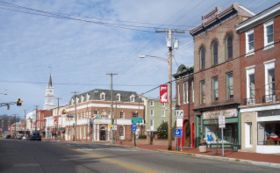
In Salem, the route intersects County Route 657 (Griffith Street) and makes a right turn. It turns left onto Broadway and forms the main business district of the town. In downtown Salem, Route 49 intersects County Route 625 (Chestnut Street), the southern terminus of Route 45 (Market Street), and County Route 665 (Walnut Street). It crosses County Route 658 (Keasbey Street/York Street) and enters Quinton Township
, becoming Main Street and heading into agricultural areas. Route 49 heads east, meeting County Route 650 (Hancocks Bridge Road) and County Route 653 (Action Station Road). It crosses the Alloway Creek
into the community of Quinton, where it intersects the southern terminus of County Route 581
(Quinton Alloway Road) and County Route 654 (Sickler Street). The route leaves Quinton and intersects County Route 626 (Jericho Road), continuing southeast into wooded areas, where Route 49 crosses County Route 667 (Pecks Corner Road) and County Route 647 (Telegraph Road/Jericho Road).
, Cumberland County
and heads into farmland as Shiloh Pike. Here, it crosses County Route 624 (Jericho Road) and County Route 617 (Columbia Highway). The route then intersects County Route 635 (Old Cohansey Road) and continues south along the border of Stow Creek Township to the west and Hopewell Township
to the east, entering Shiloh at the intersection with Mill Road. In Shiloh, Route 49 meets County Route 620 (Roadstown Road) and County Route 753 (East Avenue/West Avenue) in the center of town and heads southeast, crossing County Route 695 (Maple Avenue/Randolph Road). The route enters Hopewell Township and intersects County Route 661 (Barretts Run Road).
Past this intersection, Route 49 enters a more suburban landscape, crossing County Route 621 (W. Park Drive). The route enters Bridgeton
and becomes Broad Street. In Bridgeton, it intersects County Route 607 (West Avenue), County Route 650 (Fayette Street), and County Route 697 (Atlantic Street). Route 49 crosses the Cohansey River and comes to an intersection with Pearl Street, which heads to the north as Route 77 and to the south as County Route 609. Past Pearl Street, Route 49 crosses County Route 670 (Commerce Street/Buckshutem Road) and Route 49 continues to the east on Commerce Street. It crosses County Route 638 (N. Burlington Road) and enters Fairfield Township
.
Route 49 continues east through a mix of woods and farms, intersecting County Route 553
(Gouldtown-Woodruff Road) and County Route 675 (Fordville-Gouldtown Road). It enters Millville
and becomes Main Street, intersecting County Route 682 (Sugarman Avenue) and County Route 634 (Nabb Avenue). It intersects three more county routes, County Route 714 (Morias Avenue), County Route 625 (Hogbin Road), and County Route 712 (Reick Road), before heading into the city. It intersects County Route 608 (Carmel Road) and County Route 698 (Beech Street), County Route 667 (Sharp Street), and County Route 610 (Brandriff Avenue) before meeting County Route 555
(Cedar Street), which it forms a concurrency
with. The route crosses the Maurice River
and enters downtown Millville, where it intersects Route 47 (Second Street). Past Route 47, County Route 555 splits from Route 49 by turning north onto Third Street. Route 49 heads east through the eastern part of Millville, intersecting County Route 678 (Wade Boulevard) and interchanging with Route 55. Past Route 55, Route 49 heads southeast into woodland and crosses into Maurice River Township
. In Maurice River Township, Route 49 intersects County Route 671 (Union Road), County Route 646 (Port Elizabeth-Cumberland Road), and County Route 644 (Hesstown Road). Route 49 eventually forms the border of Maurice River Township to the north and Upper Township
, Cape May County
to the south.
into Estell Manor
, Atlantic County
. It runs a short distance to the north of the Tuckahoe River and intersects County Route 649 (Aetna Avenue) and County Route 666 (Cape May Avenue). The route crosses the Tuckahoe River into Upper Township, Cape May County and intersects the eastern terminus of County Route 548
(Tuckahoe Road), heading to the east. It intersects County Route 632 (Marshallville Road) and then comes to County Route 617 (Woodbine Road), which heads south to provide access to County Route 557
. Route 49 continues east into Tuckahoe
, where it intersects County Route 659 (Railroad Avenue) and ends at Route 50 and County Route 557.
to run from Route 45 in Salem to Route 4 (now U.S. Route 9) in Clermont. The route replaced a branch of pre-1927 Route 6 between Salem and Bridgeton
and a part of pre-1927 Route 15 between Bridgeton and South Dennis
. A spur route of Route 49, Route S49, was created in 1927 to run from Route 49 in South Dennis to Route 4 in Rio Grande
along the remainder of pre-1927 Route 15. Route S49 was extended to Wildwood
in 1938. In the 1953 New Jersey state highway renumbering
, Route 49 was extended west along what was a part of Route 44 to Deepwater to end at U.S. Route 40 and U.S. Route 130 near the Delaware Memorial Bridge. The eastern part of the route was realigned to head from Millville
east to Route 50 in Tuckahoe, replacing what had been the southern part of Route 47. Meanwhile, Route 47 was realigned to head south from Millville, replacing Route 49 from Millville to South Dennis and the length of Route S49. The portion of Route 49 from South Dennis to Clermont became Route 83.
A freeway was proposed for Route 49 in the early 1960s, running from Interstate 295 and U.S. Route 40 at the Delaware Memorial Bridge to Route 55 in Millville. However, this freeway was canceled by 1967 as it closely paralleled the planned Route 60 freeway, which itself was never built.
In the 2000s, construction has occurred to replace many bridges along Route 49. The drawbridge
over the Salem River was replaced by a fixed span in the mid-2000s. On October 1, 2008, the bridge over the railroad line in Tuckahoe was closed for reconstruction and is expected to reopen in June 2009. The bridge over the Cohansey River in Bridgeton is also being reconstructed. Construction on this bridge started in October 2008 and is expected to be completed in July 2009.
State highway
State highway, state road or state route can refer to one of three related concepts, two of them related to a state or provincial government in a country that is divided into states or provinces :#A...
in the southern part of the U.S. state
U.S. state
A U.S. state is any one of the 50 federated states of the United States of America that share sovereignty with the federal government. Because of this shared sovereignty, an American is a citizen both of the federal entity and of his or her state of domicile. Four states use the official title of...
of New Jersey
New Jersey
New Jersey is a state in the Northeastern and Middle Atlantic regions of the United States. , its population was 8,791,894. It is bordered on the north and east by the state of New York, on the southeast and south by the Atlantic Ocean, on the west by Pennsylvania and on the southwest by Delaware...
. It runs 53.8 mi (86.58 km) from an interchange with the Delaware Memorial Bridge
Delaware Memorial Bridge
The Delaware Memorial Bridge is a set of twin suspension bridges crossing the Delaware River. The toll bridges carry Interstate 295 and U.S. Route 40 between Delaware and New Jersey...
extension of the New Jersey Turnpike
New Jersey Turnpike
The New Jersey Turnpike is a toll road in New Jersey, maintained by the New Jersey Turnpike Authority. According to the International Bridge, Tunnel and Turnpike Association, the Turnpike is the nation's sixth-busiest toll road and is among one of the most heavily traveled highways in the United...
(Interstate 295
Interstate 295 (Delaware-New Jersey)
Interstate 295 in New Jersey and Delaware is an auxiliary Interstate Highway, designated as a bypass around Philadelphia, Pennsylvania. The route begins at a junction with Interstate 95 south of Wilmington, Delaware, and runs to another junction with I-95 north of Trenton, New Jersey...
and U.S. Route 40
U.S. Route 40 in New Jersey
U.S. Route 40 is a U.S. highway running from Park City, Utah east to Atlantic City, New Jersey. The easternmost segment of the route runs through the southern part of New Jersey between the Delaware Memorial Bridge over the Delaware River in Pennsville Township, Salem County, where it continues...
) in Deepwater
Deepwater, New Jersey
Deepwater is a community in Pennsville, in Salem County, New Jersey, lying at the east end of the Delaware Memorial Bridge. Deepwater is the location of the United States Postal Service area covering ZIP code 08023...
, Salem County
Salem County, New Jersey
-Demographics:As of the census of 2000, there were 64,285 people, 24,295 households, and 17,370 families residing in the county. The population density was 190 people per square mile . There were 26,158 housing units at an average density of 77 per square mile...
, where it continues north as U.S. Route 130
U.S. Route 130
U.S. Route 130 is a north–south U.S. Highway completely within the state of New Jersey. It runs from Interstate 295 and US 40 at Deepwater in Pennsville Township, Salem County, where the road continues east as Route 49, north to US 1 in North Brunswick Township, Middlesex County, where...
southeast to Route 50 and County Route 557
County Route 557 (New Jersey)
County Route 557, abbreviated CR 557, is a county highway in the U.S. state of New Jersey. The highway extends from Delsea Drive in Dennis Township to Main Street in Franklin Township.-Cape May County:...
in Tuckahoe
Tuckahoe, New Jersey
Tuckahoe is an unincorporated community in Upper Township, Cape May County, New Jersey, United States.-Bridge construction:A bridge, constructed in 1920 and renovated in 1962, connects Tuckahoe to Corbin City, its neighbor to the north...
, Cape May County
Cape May County, New Jersey
-Climate:Being the southernmost point in New Jersey, Cape May has fairly mild wintertime temperatures. Contrary to that, the summertime has lower temperatures than most places in the state, making the county a popular place to escape the heat. It is in zone 7a/7b, which is the same as parts of...
. The route serves Salem, Cumberland
Cumberland County, New Jersey
Cumberland County is a county located in the U.S. state of New Jersey. As of the 2010 Census, the population is 156,898. Its county seat is Bridgeton. Cumberland County is named for Prince William, Duke of Cumberland....
, Atlantic
Atlantic County, New Jersey
-National protected areas:* Edwin B. Forsythe National Wildlife Refuge * Great Egg Harbor Scenic and Recreational River -Demographics:...
, and Cape May Counties, passing through rural areas and the communities of Salem
Salem, New Jersey
Salem is a city in Salem County, New Jersey, United States. As of the United States 2010 Census, the city population was 5,146. It is the county seat of Salem County, the most rural county in the state of New Jersey. The name Salem is related to the Hebrew word shalom, meaning "peace".The town and...
, Bridgeton
Bridgeton, New Jersey
Bridgeton is a city in Cumberland County, New Jersey, United States, in the south part of the state, on the Cohansey River, near Delaware Bay. As of the 2010 United States Census, the city population was 25,349. It is the county seat of Cumberland County...
, and Millville
Millville, New Jersey
Millville is a city in Cumberland County, New Jersey, United States. As of the 2000 United States Census, the city population was 26,847. Millville, Bridgeton and Vineland are the three principal New Jersey cities of the Vineland-Millville-Bridgeton Primary Metropolitan Statistical Area which...
along the way. It is a two-lane, undivided road for most of its length.
Route 49 was established in 1927 to run from Salem to Clermont, running along its present alignment between Salem and Millville, following current Route 47 between Millville and South Dennis
South Dennis, New Jersey
South Dennis is an unincorporated area in Dennis Township, in Cape May County, New Jersey, United States. It is part of the Ocean City Metropolitan Statistical Area. Its postal ZIP Code is 08245.-Demographics:...
, and running along present-day Route 83 between South Dennis and Clermont. It replaced a branch of pre-1927 Route 6 between Salem and Bridgeton and a part of pre-1927 Route 15 between Bridgeton and South Dennis. In 1953, Route 49 was routed onto its current alignment, replacing a part of Route 44 between Salem and Deepwater and following the former alignment of Route 47 between Millville and Tuckahoe. In the 1960s, a freeway was planned for Route 49 between Deepwater and Millville; it was never built. In the 2000s, many improvements have been or are being made to bridges along Route 49.
Salem County
Delaware Memorial Bridge
The Delaware Memorial Bridge is a set of twin suspension bridges crossing the Delaware River. The toll bridges carry Interstate 295 and U.S. Route 40 between Delaware and New Jersey...
extension of the New Jersey Turnpike
New Jersey Turnpike
The New Jersey Turnpike is a toll road in New Jersey, maintained by the New Jersey Turnpike Authority. According to the International Bridge, Tunnel and Turnpike Association, the Turnpike is the nation's sixth-busiest toll road and is among one of the most heavily traveled highways in the United...
(Interstate 295
Interstate 295 (Delaware-New Jersey)
Interstate 295 in New Jersey and Delaware is an auxiliary Interstate Highway, designated as a bypass around Philadelphia, Pennsylvania. The route begins at a junction with Interstate 95 south of Wilmington, Delaware, and runs to another junction with I-95 north of Trenton, New Jersey...
/U.S. Route 40
U.S. Route 40 in New Jersey
U.S. Route 40 is a U.S. highway running from Park City, Utah east to Atlantic City, New Jersey. The easternmost segment of the route runs through the southern part of New Jersey between the Delaware Memorial Bridge over the Delaware River in Pennsville Township, Salem County, where it continues...
) in the community of Deepwater
Deepwater, New Jersey
Deepwater is a community in Pennsville, in Salem County, New Jersey, lying at the east end of the Delaware Memorial Bridge. Deepwater is the location of the United States Postal Service area covering ZIP code 08023...
in Pennsville Township
Pennsville Township, New Jersey
Pennsville Township is a Township in Salem County, New Jersey, United States. As of the 2000 United States Census, the township population was 13,194. The township is named for William Penn....
, Salem County
Salem County, New Jersey
-Demographics:As of the census of 2000, there were 64,285 people, 24,295 households, and 17,370 families residing in the county. The population density was 190 people per square mile . There were 26,158 housing units at an average density of 77 per square mile...
. North of here, the road continues to the north as U.S. Route 130
U.S. Route 130
U.S. Route 130 is a north–south U.S. Highway completely within the state of New Jersey. It runs from Interstate 295 and US 40 at Deepwater in Pennsville Township, Salem County, where the road continues east as Route 49, north to US 1 in North Brunswick Township, Middlesex County, where...
. Route 49 passes through residential areas of Pennsville and intersects County Route 630 (Fort Mott Road), continuing into farmland. Route 49 then intersects the southern terminus of County Route 551
County Route 551 (New Jersey)
County Route 551, abbreviated CR 551, is a county highway in the U.S. state of New Jersey. The highway extends from Pennsville-Salem Road in Pennsville Township to Penn Street in Camden.-Salem County:...
(Hook Road and County Route 632 (Lighthouse Road). It crosses the Salem River
Salem River
The Salem River is a tributary of the Delaware River in southwestern New Jersey in the United States.The course and watershed of the Salem River are entirely within Salem County. The river rises in Upper Pittsgrove Township and flows initially westwardly, through Pilesgrove Township and the...
into Salem
Salem, New Jersey
Salem is a city in Salem County, New Jersey, United States. As of the United States 2010 Census, the city population was 5,146. It is the county seat of Salem County, the most rural county in the state of New Jersey. The name Salem is related to the Hebrew word shalom, meaning "peace".The town and...
and becomes Front Street.
In Salem, the route intersects County Route 657 (Griffith Street) and makes a right turn. It turns left onto Broadway and forms the main business district of the town. In downtown Salem, Route 49 intersects County Route 625 (Chestnut Street), the southern terminus of Route 45 (Market Street), and County Route 665 (Walnut Street). It crosses County Route 658 (Keasbey Street/York Street) and enters Quinton Township
Quinton Township, New Jersey
Quinton Township is a Township in Salem County, New Jersey, United States. As of the United States 2000 Census, the township population was 2,786....
, becoming Main Street and heading into agricultural areas. Route 49 heads east, meeting County Route 650 (Hancocks Bridge Road) and County Route 653 (Action Station Road). It crosses the Alloway Creek
Alloway Creek
Alloway Creek is a tributary of the Delaware River in Salem County, southwestern New Jersey in the U.S.The headwaters of the creek are to the southeast of Daretown, in Upper Pittsgrove Township. It flows roughly parallel and to the south of Commissioners Pike, meeting Cool Run before turning west...
into the community of Quinton, where it intersects the southern terminus of County Route 581
County Route 581 (New Jersey)
County Route 581, abbreviated CR 581, is a county highway in the U.S. state of New Jersey. The highway extends from Main Street in Quinton Township to Bridgeton Pike in Harrison Township.-Route description:...
(Quinton Alloway Road) and County Route 654 (Sickler Street). The route leaves Quinton and intersects County Route 626 (Jericho Road), continuing southeast into wooded areas, where Route 49 crosses County Route 667 (Pecks Corner Road) and County Route 647 (Telegraph Road/Jericho Road).
Cumberland County
Route 49 crosses a stream, Sarah Run, into Stow Creek TownshipStow Creek Township, New Jersey
Stow Creek Township is a township in Cumberland County, New Jersey, United States. It is part of the Vineland-Millville-Bridgeton Primary Metropolitan Statistical Area for statistical purposes...
, Cumberland County
Cumberland County, New Jersey
Cumberland County is a county located in the U.S. state of New Jersey. As of the 2010 Census, the population is 156,898. Its county seat is Bridgeton. Cumberland County is named for Prince William, Duke of Cumberland....
and heads into farmland as Shiloh Pike. Here, it crosses County Route 624 (Jericho Road) and County Route 617 (Columbia Highway). The route then intersects County Route 635 (Old Cohansey Road) and continues south along the border of Stow Creek Township to the west and Hopewell Township
Hopewell Township, Cumberland County, New Jersey
Hopewell Township is a township in Cumberland County, New Jersey, in the United States. It is part of the Vineland-Millville- Bridgeton Primary Metropolitan Statistical Area for statistical purposes...
to the east, entering Shiloh at the intersection with Mill Road. In Shiloh, Route 49 meets County Route 620 (Roadstown Road) and County Route 753 (East Avenue/West Avenue) in the center of town and heads southeast, crossing County Route 695 (Maple Avenue/Randolph Road). The route enters Hopewell Township and intersects County Route 661 (Barretts Run Road).
Past this intersection, Route 49 enters a more suburban landscape, crossing County Route 621 (W. Park Drive). The route enters Bridgeton
Bridgeton, New Jersey
Bridgeton is a city in Cumberland County, New Jersey, United States, in the south part of the state, on the Cohansey River, near Delaware Bay. As of the 2010 United States Census, the city population was 25,349. It is the county seat of Cumberland County...
and becomes Broad Street. In Bridgeton, it intersects County Route 607 (West Avenue), County Route 650 (Fayette Street), and County Route 697 (Atlantic Street). Route 49 crosses the Cohansey River and comes to an intersection with Pearl Street, which heads to the north as Route 77 and to the south as County Route 609. Past Pearl Street, Route 49 crosses County Route 670 (Commerce Street/Buckshutem Road) and Route 49 continues to the east on Commerce Street. It crosses County Route 638 (N. Burlington Road) and enters Fairfield Township
Fairfield Township, Cumberland County, New Jersey
Fairfield Township is a township in Cumberland County, New Jersey, United States. It is part of the Vineland-Millville- Bridgeton Primary Metropolitan Statistical Area for statistical purposes...
.
Route 49 continues east through a mix of woods and farms, intersecting County Route 553
County Route 553 (New Jersey)
County Route 553, abbreviated CR 553, is a county highway in the U.S. state of New Jersey. The highway extends from Hands Landing Road/Ogden Avenue in Commercial Township to Broadway in Deptford Township.-Cumberland County:...
(Gouldtown-Woodruff Road) and County Route 675 (Fordville-Gouldtown Road). It enters Millville
Millville, New Jersey
Millville is a city in Cumberland County, New Jersey, United States. As of the 2000 United States Census, the city population was 26,847. Millville, Bridgeton and Vineland are the three principal New Jersey cities of the Vineland-Millville-Bridgeton Primary Metropolitan Statistical Area which...
and becomes Main Street, intersecting County Route 682 (Sugarman Avenue) and County Route 634 (Nabb Avenue). It intersects three more county routes, County Route 714 (Morias Avenue), County Route 625 (Hogbin Road), and County Route 712 (Reick Road), before heading into the city. It intersects County Route 608 (Carmel Road) and County Route 698 (Beech Street), County Route 667 (Sharp Street), and County Route 610 (Brandriff Avenue) before meeting County Route 555
County Route 555 (New Jersey)
County Route 555, abbreviated CR 555, is a county highway in the U.S. state of New Jersey. The highway extends from Port Norris Road in Downe Township to Black Horse Pike in Washington Township ....
(Cedar Street), which it forms a concurrency
Concurrency (road)
A concurrency, overlap, or coincidence in a road network is an instance of one physical road bearing two or more different highway, motorway, or other route numbers...
with. The route crosses the Maurice River
Maurice River
The Maurice River is a river that empties into the Delaware Bay in southern New Jersey in the United States.The Maurice River, pronounced "Morris", is approximately long and is the second longest and largest tributary to Delaware Bay. Its watershed includes an extensive southern portion of the...
and enters downtown Millville, where it intersects Route 47 (Second Street). Past Route 47, County Route 555 splits from Route 49 by turning north onto Third Street. Route 49 heads east through the eastern part of Millville, intersecting County Route 678 (Wade Boulevard) and interchanging with Route 55. Past Route 55, Route 49 heads southeast into woodland and crosses into Maurice River Township
Maurice River Township, New Jersey
Maurice River Township is a township in Cumberland County, New Jersey, United States. It is part of the Vineland-Millville- Bridgeton Primary Metropolitan Statistical Area for statistical purposes...
. In Maurice River Township, Route 49 intersects County Route 671 (Union Road), County Route 646 (Port Elizabeth-Cumberland Road), and County Route 644 (Hesstown Road). Route 49 eventually forms the border of Maurice River Township to the north and Upper Township
Upper Township, New Jersey
Upper Township is a large township in Cape May County, New Jersey, United States. It is part of the Ocean City Metropolitan Statistical Area. The township population was 12,115 as of the United States 2000 Census...
, Cape May County
Cape May County, New Jersey
-Climate:Being the southernmost point in New Jersey, Cape May has fairly mild wintertime temperatures. Contrary to that, the summertime has lower temperatures than most places in the state, making the county a popular place to escape the heat. It is in zone 7a/7b, which is the same as parts of...
to the south.
Atlantic and Cape May Counties
Route 49 crosses the Tuckahoe RiverTuckahoe River (New Jersey)
The Tuckahoe River is a blackwater river in southern New Jersey in the United States. The river drains an area of the southern Pinelands and empties into the Atlantic Ocean...
into Estell Manor
Estell Manor, New Jersey
Estell Manor is a city in Atlantic County, New Jersey, United States. As of the 2010 United States Census, the city population was 1,735.Estell Manor was incorporated as a city by an Act of the New Jersey Legislature on March 14, 1925, from portions of Weymouth Township.-Geography:Estell Manor is...
, Atlantic County
Atlantic County, New Jersey
-National protected areas:* Edwin B. Forsythe National Wildlife Refuge * Great Egg Harbor Scenic and Recreational River -Demographics:...
. It runs a short distance to the north of the Tuckahoe River and intersects County Route 649 (Aetna Avenue) and County Route 666 (Cape May Avenue). The route crosses the Tuckahoe River into Upper Township, Cape May County and intersects the eastern terminus of County Route 548
County Route 548 (New Jersey)
County Route 548, abbreviated CR 548, is a county highway in the U.S. state of New Jersey. The highway extends from Delsea Drive County Route 548, abbreviated CR 548, is a county highway in the U.S. state of New Jersey. The highway extends from Delsea Drive County Route 548, abbreviated CR 548,...
(Tuckahoe Road), heading to the east. It intersects County Route 632 (Marshallville Road) and then comes to County Route 617 (Woodbine Road), which heads south to provide access to County Route 557
County Route 557 (New Jersey)
County Route 557, abbreviated CR 557, is a county highway in the U.S. state of New Jersey. The highway extends from Delsea Drive in Dennis Township to Main Street in Franklin Township.-Cape May County:...
. Route 49 continues east into Tuckahoe
Tuckahoe, New Jersey
Tuckahoe is an unincorporated community in Upper Township, Cape May County, New Jersey, United States.-Bridge construction:A bridge, constructed in 1920 and renovated in 1962, connects Tuckahoe to Corbin City, its neighbor to the north...
, where it intersects County Route 659 (Railroad Avenue) and ends at Route 50 and County Route 557.
History
Route 49 was legislated in the 1927 New Jersey state highway renumbering1927 New Jersey state highway renumbering
In 1927, New Jersey's state highways were renumbered. The old system, which had been defined in sequence by the legislature, was growing badly, as several routes shared the same number, and many unnumbered state highways had been defined...
to run from Route 45 in Salem to Route 4 (now U.S. Route 9) in Clermont. The route replaced a branch of pre-1927 Route 6 between Salem and Bridgeton
Bridgeton, New Jersey
Bridgeton is a city in Cumberland County, New Jersey, United States, in the south part of the state, on the Cohansey River, near Delaware Bay. As of the 2010 United States Census, the city population was 25,349. It is the county seat of Cumberland County...
and a part of pre-1927 Route 15 between Bridgeton and South Dennis
South Dennis, New Jersey
South Dennis is an unincorporated area in Dennis Township, in Cape May County, New Jersey, United States. It is part of the Ocean City Metropolitan Statistical Area. Its postal ZIP Code is 08245.-Demographics:...
. A spur route of Route 49, Route S49, was created in 1927 to run from Route 49 in South Dennis to Route 4 in Rio Grande
Rio Grande, New Jersey
Rio Grande is a census-designated place and unincorporated area located within Middle Township, in Cape May County, New Jersey. It is part of the Ocean City Metropolitan Statistical Area...
along the remainder of pre-1927 Route 15. Route S49 was extended to Wildwood
Wildwood, New Jersey
Wildwood is a city in Cape May County, New Jersey, United States. It is part of the Ocean City Metropolitan Statistical Area and is a popular summer resort destination. As of the 2010 United States Census, the city's year-round population was 5,325...
in 1938. In the 1953 New Jersey state highway renumbering
1953 New Jersey state highway renumbering
On January 1, 1953, the New Jersey Department of Transportation renumbered many of the State Routes. A few rules were followed in deciding what to renumber:...
, Route 49 was extended west along what was a part of Route 44 to Deepwater to end at U.S. Route 40 and U.S. Route 130 near the Delaware Memorial Bridge. The eastern part of the route was realigned to head from Millville
Millville, New Jersey
Millville is a city in Cumberland County, New Jersey, United States. As of the 2000 United States Census, the city population was 26,847. Millville, Bridgeton and Vineland are the three principal New Jersey cities of the Vineland-Millville-Bridgeton Primary Metropolitan Statistical Area which...
east to Route 50 in Tuckahoe, replacing what had been the southern part of Route 47. Meanwhile, Route 47 was realigned to head south from Millville, replacing Route 49 from Millville to South Dennis and the length of Route S49. The portion of Route 49 from South Dennis to Clermont became Route 83.
A freeway was proposed for Route 49 in the early 1960s, running from Interstate 295 and U.S. Route 40 at the Delaware Memorial Bridge to Route 55 in Millville. However, this freeway was canceled by 1967 as it closely paralleled the planned Route 60 freeway, which itself was never built.
In the 2000s, construction has occurred to replace many bridges along Route 49. The drawbridge
Drawbridge
A drawbridge is a type of movable bridge typically associated with the entrance of a castle surrounded by a moat. The term is often used to describe all different types of movable bridges, like bascule bridges and lift bridges.-Castle drawbridges:...
over the Salem River was replaced by a fixed span in the mid-2000s. On October 1, 2008, the bridge over the railroad line in Tuckahoe was closed for reconstruction and is expected to reopen in June 2009. The bridge over the Cohansey River in Bridgeton is also being reconstructed. Construction on this bridge started in October 2008 and is expected to be completed in July 2009.