
Rosthwaite Fell
Encyclopedia
Fell
“Fell” is a word used to refer to mountains, or certain types of mountainous landscape, in Scandinavia, the Isle of Man, and parts of northern England.- Etymology :...
in the English Lake District
Lake District
The Lake District, also commonly known as The Lakes or Lakeland, is a mountainous region in North West England. A popular holiday destination, it is famous not only for its lakes and its mountains but also for its associations with the early 19th century poetry and writings of William Wordsworth...
. It is situated some 12 kilometres (7.5 mi) due south of Keswick
Keswick, Cumbria
Keswick is a market town and civil parish within the Borough of Allerdale in Cumbria, England. It had a population of 4,984, according to the 2001 census, and is situated just north of Derwent Water, and a short distance from Bassenthwaite Lake, both in the Lake District National Park...
and 2 kilometres (1.2 mi) south of the village of Rosthwaite
Rosthwaite, Borrowdale, Cumbria
Rosthwaite is a settlement in Borrowdale in the English Lake District. It lies on the B5289 road to the south of Derwent Water and to the east of the Honister Pass in the county of Cumbria....
in Borrowdale
Borrowdale
Borrowdale is a valley and civil parish in the English Lake District in the Borough of Allerdale in Cumbria, England.Borrowdale lies within the historic county boundaries of Cumberland, and is sometimes referred to as Cumberland Borrowdale in order to distinguish it from another Borrowdale in the...
.
Rosthwaite Fell also has loose connections to the Scafell group of fells. The fells name derives from the Old Norse
Old Norse
Old Norse is a North Germanic language that was spoken by inhabitants of Scandinavia and inhabitants of their overseas settlements during the Viking Age, until about 1300....
language and means “The peak above the clearing with a heap of stones” with “hreysi” meaning a heap of stones and “thveit” meaning a clearing.
Topography
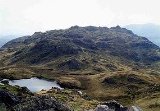
Rosthwaite Fell reaches a height of 612 m (2,008 ft) at its highest point, which is commonly known as Rosthwaite Cam. It also has a subsidiary top, Bessyboot (550 m, 1,804 ft ), which lies 800 metres north of the main summit. Alfred WainwrightAlfred Wainwright
Alfred Wainwright MBE was a British fellwalker, guidebook author and illustrator. His seven-volume Pictorial Guide to the Lakeland Fells, published between 1955 and 1966 and consisting entirely of reproductions of his manuscript, has become the standard reference work to 214 of the fells of the...
took Bessyboot as the summit of the fell for his Pictorial Guide to the Lakeland Fells
Pictorial Guide to the Lakeland Fells
A Pictorial Guide to the Lakeland Fells is a series of seven books by A. Wainwright, detailing the fells of the Lake District in northwest England...
. Dovenest Crag, which lies 500 metres south west of the summit, is generally considered to be a part of Glaramara
Glaramara
Glaramara is a fell in the English Lake District in Cumbria. It is a substantial fell that is part of a long ridge that stretches for over six kilometres from Stonethwaite in Borrowdale up to the important mountain pass of Esk Hause...
and is covered in that article.
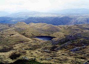
The fell's boundaries are clearly defined to the north, west and east by valleys and streams. The western side falls to Borrowdale and the infant River Derwent
River Derwent, Cumbria
The Derwent is a river in the Lake District of the county of Cumbria in the north of England. The name Derwent is derived from a Celtic word for "oak trees"....
, the eastern flank descends to the Langstrath valley and its beck while the northern slopes go down to the Stonethwaite
Stonethwaite
Stonethwaite is a small village in the Lake District in the English county of Cumbria. It is situated in the valley of the Stonethwaite Beck, a side valley of Borrowdale, and within the Lake District National Park...
valley. To the south, Rosthwaite Fell is linked to the higher and better known fell of Glaramara
Glaramara
Glaramara is a fell in the English Lake District in Cumbria. It is a substantial fell that is part of a long ridge that stretches for over six kilometres from Stonethwaite in Borrowdale up to the important mountain pass of Esk Hause...
by a marshy and undulating ridge which goes over several subsidiary tops on the way.
Rosthwaite Fell is craggy and steep on the three sides that descend to valleys and there is no simple and appealing route of ascent. This, combined with the fact that there are many more attractive climbs in the area, makes the fell a quiet and unfrequented place.
Geology
Because of its unique geology, Rosthwaite Fell was declared a Site of Special Scientific InterestSite of Special Scientific Interest
A Site of Special Scientific Interest is a conservation designation denoting a protected area in the United Kingdom. SSSIs are the basic building block of site-based nature conservation legislation and most other legal nature/geological conservation designations in Great Britain are based upon...
in 1985 over an area of 230 hectares. With the English Nature
English Nature
English Nature was the United Kingdom government agency that promoted the conservation of wildlife, geology and wild places throughout England between 1990 and 2006...
web site saying:
"The extensive crags and rock outcrops within this site provide outstanding exposures of a thick succession of volcanic rock-layers representing a large proportion of the important episode of volcanic activity which generated the Borrowdale Volcanic Group during the middle Ordovician Period of geological history, about 460 million years ago. A wide variety of different rocktypes are present and well exposed within the site. This is an important site as a reference section for detailed geological study and is of historical interest as an area where certain volcanic rock-types were first recognised."