
Rolling Road
Encyclopedia
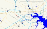
Rolling Road is a major cross county road that runs through Baltimore County, Maryland
. The road, once a continuous route, is divided into two by Interstate 95
. A portion of the road in the Catonsville area is Maryland Route 166, and the remainder is a county roadway.
(near Arbutus
), near the partial-cloverleaf interchange between I-195
and US 1
. It runs northwest in a straight line as a quiet suburban street, crossing the B&O main line via a bridge just to the south of St. Denis station
. The name turns to the northeast at an intersection with Railroad Avenue, and continues as a suburban street to another intersection with Cedar Avenue. Turning northwest once again, the road runs in a straight line and eventually terminates at a dead end beneath the large hybrid cloverleaf interchange between I-95
and I-195.
The road resumes at the entrance gates to the University of Maryland, Baltimore County, just to the northwest of said interchange. It continues to the north, paralleling MD 166, and eventually meets Selford Road, which crosses MD 166 via an overpass. Turning to the northwest, the road continues parallel to MD 166 and eventually intersects it at the northern terminus of the Metropolitan Boulevard freeway. (MD 166 at this point follows north from the end of the I-195 designation near the Interstate 95 interchange.)
Now under state maintenance, the route is now signed as Maryland Route 166. It intersects MD 372
at the southern corner of the Rolling Road Golf Course. Continuing parallel to the border of the golf course, MD 166 intersects Bloomsbury Avenue, a major suburban thoroughfare, before entering the southwestern neighborhoods of Catonsville
. Once past Bloomsbury Avenue, the road becomes a suburban street again, although a very busy one; the route is a well-known shortcut for traffic avoiding I-695
. Crossing the street grid at a diagonal, the route eventually intersects Hilton Avenue at a tight angle. Beyond Hilton Avenue, the route turns due north, and both the state highway designation and the roadway terminate at MD 144
.
, where it widens to a four-lane boulevard to intersect US 40
. Condensing to two lanes shortly afterward, it then continues north, passing through a large residential area. After it intersects MD 122, it passes through Windsor Mill and Randallstown
, intersecting Windsor Mill Road
, Milford Mill Road and MD 26 along the way, before terminating at Old Court Road
in Pikesville.
:
Baltimore County, Maryland
Baltimore County is a county located in the northern part of the US state of Maryland. In 2010, its population was 805,029. It is part of the Baltimore-Washington Metropolitan Area. Its county seat is Towson. The name of the county was derived from the barony of the Proprietor of the Maryland...
. The road, once a continuous route, is divided into two by Interstate 95
Interstate 95 in Maryland
Interstate 95 in Maryland is a major highway that runs diagonally from northeast to southwest, from Maryland's border with Delaware, to the Woodrow Wilson Bridge, briefly entering the District of Columbia before reaching Virginia...
. A portion of the road in the Catonsville area is Maryland Route 166, and the remainder is a county roadway.
History
The name "Rolling Road" was given to the road from now obsolete tobacco hogsheds being rolled to the port down the road. This name has been used for the road for more than 200 years.South Rolling Road
South Rolling Road begins at the intersection of South Street and East Street in the neighborhood of St. DenisSt. Denis, Maryland
St. Denis is a locality in central Maryland in the United States, located somewhat south of Baltimore.It is located on the CSX main line between Halethorpe and Relay , and is best known as a stop on the MARC commuter rail...
(near Arbutus
Arbutus, Maryland
As of the 2010 Census Arbutus had a population of 20,583. The racial and ethnic compositon of the population was 76.6% non-Hispanic white, 9.5% non-Hispanic black, 0.2% Native American, 2.1% Asian Indian, 6.5% other Asian, 0.1% Pacific Islander, 0.2% non-Hispanic from some other race, 2.3% from...
), near the partial-cloverleaf interchange between I-195
Interstate 195 (Maryland)
Interstate 195 is an Interstate highway in the U.S. state of Maryland. Known as Metropolitan Boulevard, the highway runs from Baltimore/Washington International Thurgood Marshall Airport in Linthicum north to I-95 in Arbutus, where Metropolitan Boulevard continues north as Maryland Route 166 ,...
and US 1
U.S. Route 1 in Maryland
U.S. Route 1 is the easternmost and longest of the major north–south routes of the United States Numbered Highway System, running from Key West, Florida to Fort Kent, Maine. In the U.S...
. It runs northwest in a straight line as a quiet suburban street, crossing the B&O main line via a bridge just to the south of St. Denis station
St Denis (MARC station)
St. Denis is a passenger rail station on the MARC Camden Line in the Maryland town of the same name. While the small station is the line's closest station to its terminus at Camden Yards in Baltimore, it has low ridership and is designated a flag stop: trains do not stop unless the engineer sees...
. The name turns to the northeast at an intersection with Railroad Avenue, and continues as a suburban street to another intersection with Cedar Avenue. Turning northwest once again, the road runs in a straight line and eventually terminates at a dead end beneath the large hybrid cloverleaf interchange between I-95
Interstate 95 in Maryland
Interstate 95 in Maryland is a major highway that runs diagonally from northeast to southwest, from Maryland's border with Delaware, to the Woodrow Wilson Bridge, briefly entering the District of Columbia before reaching Virginia...
and I-195.
The road resumes at the entrance gates to the University of Maryland, Baltimore County, just to the northwest of said interchange. It continues to the north, paralleling MD 166, and eventually meets Selford Road, which crosses MD 166 via an overpass. Turning to the northwest, the road continues parallel to MD 166 and eventually intersects it at the northern terminus of the Metropolitan Boulevard freeway. (MD 166 at this point follows north from the end of the I-195 designation near the Interstate 95 interchange.)
Now under state maintenance, the route is now signed as Maryland Route 166. It intersects MD 372
Maryland Route 372
Maryland Route 372 is a state highway in the U.S. state of Maryland. The state highway runs from MD 166 in Arbutus east to U.S. Route 1 in Baltimore.-Route description:...
at the southern corner of the Rolling Road Golf Course. Continuing parallel to the border of the golf course, MD 166 intersects Bloomsbury Avenue, a major suburban thoroughfare, before entering the southwestern neighborhoods of Catonsville
Catonsville, Maryland
According to the United States Census Bureau, the CDP has a total area of , all of it land.-Demographics:In 2010 Catonsville had a population of 41,567...
. Once past Bloomsbury Avenue, the road becomes a suburban street again, although a very busy one; the route is a well-known shortcut for traffic avoiding I-695
Interstate 695 (Maryland)
Interstate 695 is a -long full beltway Interstate Highway extending around Baltimore, Maryland, USA. I-695 is officially designated the McKeldin Beltway, but is colloquially referred to as either the Baltimore Beltway or 695...
. Crossing the street grid at a diagonal, the route eventually intersects Hilton Avenue at a tight angle. Beyond Hilton Avenue, the route turns due north, and both the state highway designation and the roadway terminate at MD 144
Maryland Route 144
Maryland Route 144 is a collection of state highways in the U.S. state of Maryland. These highways are sections of old alignment of U.S. Route 40 between Cumberland and Baltimore...
.
N. Rolling Road
The road resumes a half-mile to the west of the northern terminus of MD 166, and is known as North Rolling Road. The road generally parallels the Baltimore Beltway to its east. It runs through WoodlawnWoodlawn, Maryland
Woodlawn is the name of some places in the U.S. state of Maryland:*Woodlawn, Baltimore County, Maryland*Woodlawn, Prince George's County, Maryland...
, where it widens to a four-lane boulevard to intersect US 40
U.S. Route 40 in Maryland
U.S. Route 40 in the U.S. state of Maryland runs from western Maryland to Cecil County in the state's northeastern corner. With a total length of over , it is the longest numbered highway in Maryland. Almost half of the road overlaps with Interstate 68 or Interstate 70, while the old alignment...
. Condensing to two lanes shortly afterward, it then continues north, passing through a large residential area. After it intersects MD 122, it passes through Windsor Mill and Randallstown
Randallstown, Maryland
Randallstown is an unincorporated community and a census-designated place in Baltimore County, Maryland, United States. It is named after Christopher and Thomas Randall, two 18th-century tavern-keepers. At that time, Randallstown was a tollgate crossroads on the Liberty Turnpike, a major east-west...
, intersecting Windsor Mill Road
Windsor Mill Road
Windsor Mill Road is a road that runs through parts of Baltimore, Maryland and its western suburb Woodlawn. The road starts as a one way street named Edgewood Street, then makes a slight left corner and becomes Windsor Mill Road...
, Milford Mill Road and MD 26 along the way, before terminating at Old Court Road
Old Court Road
Old Court Road is a major cross-county road in the central region of the U.S. state of Maryland, running east–west for approximately through Baltimore County, Maryland from just inside Howard County, Maryland at Woodstock on the Patapsco River to Maryland Route 25 near Towson...
in Pikesville.
Junction list
This listing enumerates the junctions along the state-maintained segment of S. Rolling Road, signed as MD 166.| Location | Mile | Destinations | Notes |
|---|---|---|---|
   |
|||
| Arbutus Arbutus, Maryland As of the 2010 Census Arbutus had a population of 20,583. The racial and ethnic compositon of the population was 76.6% non-Hispanic white, 9.5% non-Hispanic black, 0.2% Native American, 2.1% Asian Indian, 6.5% other Asian, 0.1% Pacific Islander, 0.2% non-Hispanic from some other race, 2.3% from... |
0.0 | – BWI Airport | Southern terminus Eastbound carriageway signed as I-195 near South Rolling Road intersection; northbound MD 166 is unsigned south of South Rolling Road |
| 0.36 | UMBC Boulevard north – University of Maryland | northbound exit and southbound entrance | |
| 0.56 | S. Rolling Rd. - Park and Ride Park and ride Park and ride facilities are car parks with connections to public transport that allow commuters and other people wishing to travel into city centres to leave their vehicles and transfer to a bus, rail system , or carpool for the rest of their trip... |
MD 166 downgrades to two-lane suburban highway | |
| 0.81 | Highfields Drive | access controls on MD 166 end near here | |
| 0.95 | also provides access to University of Maryland campus | ||
| 1.06 | Collegiate Drive | ||
| 1.47 | Campus Drive/Valley Road | ||
| Catonsville Catonsville, Maryland According to the United States Census Bureau, the CDP has a total area of , all of it land.-Demographics:In 2010 Catonsville had a population of 41,567... |
1.74 | Bloomsbury Avenue north | |
| 1.99 | Newburg Avenue | ||
| 2.19 | Gary Drive/Brook Road | ||
| 2.37 | Park Drive | ||
| 2.59 | Hilton Avenue south – Patapsco Valley State Park Patapsco Valley State Park Patapsco Valley State Park is located in Maryland, USA and extends along 32 miles of the Patapsco River, encompassing and five developed recreational areas. Recreational opportunities include hiking, fishing, camping, canoeing, horseback riding and mountain bike trails, as well as picnicking for... |
||
| 2.71 | Northern terminus North Rolling Road begins 1/2 mile west of intersection |
||
Public transportation
Portions of Rolling Road are served by various bus lines operated by the Maryland Transit AdministrationMaryland Transit Administration
The Maryland Transit Administration is a state-operated mass transit administration in Maryland, and is part of the Maryland Department of Transportation. It is better known as MTA Maryland to avoid confusion with other cities' transit agencies who share the initials MTA. The MTA operates a...
:
- The block from Liberty RoadMaryland Route 26Maryland Route 26 is an east–west state highway in the U.S. state of Maryland. Outside of the Baltimore city limits, it is known as Liberty Road; inside the city limits it is known as Liberty Heights Avenue....
to Church Lane is part of the loop of Route 52Route 52 (MTA Maryland)Route 52 is a bus route operated by the Maryland Transit Administration in Baltimore and its suburbs. The line currently runs from the Mondawmin Metro Subway Station along Liberty Heights Avenue and Liberty Road to a loop known as in Milford Mill with buses marked as "Milford Mill"...
. - Route 77Route 77 (MTA Maryland)Route 77 is a bus route operated by the Maryland Transit Administration in the suburbs of Baltimore. The line currently runs from the Old Court Metro Subway Station in Pikesville, Maryland to the Patapsco Light Rail Stop, and serves Randallstown, Windsor Mill, Woodlawn, Catonsville, Arbutus,...
operates on various segments in Woodlawn and Catonsville - The portion outside Security Square Mall is part of the loop of several lines.
- Route 20 operates from Security to Crosby Road.
- Route 23 operates between Baltimore National Pike and Edmondson Avenue, and Route 10 to Frederick RoadMaryland Route 144Maryland Route 144 is a collection of state highways in the U.S. state of Maryland. These highways are sections of old alignment of U.S. Route 40 between Cumberland and Baltimore...
.