
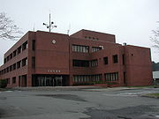
Rokunohe, Aomori
Encyclopedia
Towns of Japan
A town is a local administrative unit in Japan. It is a local public body along with prefecture , city , and village...
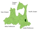
located in the Kamikita District
Kamikita District, Aomori
is a district located in Aomori Prefecture, Japan. It occupies the east-central portion of the prefecture, south of Shimokita Peninsula.As of 2010, the district has an estimated population of 100,526 and a density of 78.5 persons per km². The total area was 1281.05 km².- Towns and villages...
of northeastern Aomori Prefecture
Aomori Prefecture
is a prefecture of Japan located in the Tōhoku Region. The capital is the city of Aomori.- History :Until the Meiji Restoration, the area of Aomori prefecture was known as Mutsu Province....
in the Tōhoku region
Tohoku region
The is a geographical area of Japan. The region occupies the northeastern portion of Honshu, the largest island of Japan. The region consists of six prefectures : Akita, Aomori, Fukushima, Iwate, Miyagi and Yamagata....
of Japan
Japan
Japan is an island nation in East Asia. Located in the Pacific Ocean, it lies to the east of the Sea of Japan, China, North Korea, South Korea and Russia, stretching from the Sea of Okhotsk in the north to the East China Sea and Taiwan in the south...
. As of 2009, the town had an estimated population
Population
A population is all the organisms that both belong to the same group or species and live in the same geographical area. The area that is used to define a sexual population is such that inter-breeding is possible between any pair within the area and more probable than cross-breeding with individuals...
of 10,197 and a density
Population density
Population density is a measurement of population per unit area or unit volume. It is frequently applied to living organisms, and particularly to humans...
of 121 persons per km². Its total area was 84.06 km².
Geography
Rokunohe is in east-central Aomori prefecture, in relatively flat lands watered by the Oirase RiverOirase River
The is a river located in eastern Aomori prefecture, Japan.The Oirase River is the only river draining Lake Towada, a large caldera lake on the border of Aomori and Akita Prefectures. The river flows in a generally eastern direction, through the municipalities of Towada, Rokunohe, Oirase and...
. The town has a cold maritime climate characterized by cool short summers and long cold winters with heavy snowfall.
Neighbouring municipalities
- MisawaMisawa, Aomoriis a city located in eastern Aomori Prefecture in the Tōhoku region of Japan. As of 2009, the city had an estimated population of 42,399 and a density of 353 persons per km²...
- TowadaTowada, Aomoriis a city located in central Aomori in Tōhoku region of Japan. As of 2009, the city had an estimated population of 65,818 and a density of 90.7 persons per km². Its total area was 725.67 km², making it the largest municipality in Aomori Prefecture in terms of area.-Geography:Towada is located in...
- Kamikita DistrictKamikita District, Aomoriis a district located in Aomori Prefecture, Japan. It occupies the east-central portion of the prefecture, south of Shimokita Peninsula.As of 2010, the district has an estimated population of 100,526 and a density of 78.5 persons per km². The total area was 1281.05 km².- Towns and villages...
- TōhokuTohoku, Aomoriis a town located in the Kamikita District of northeastern Aomori Prefecture in the Tōhoku region of Japan. As of 2009, the village had an estimated population of 19,051 and a density of 58.3 persons per km². Its total area was 326.71 km².-Geography:...
- OiraseOirase, Aomoriis a town located in the Kamikita District of eastern Aomori Prefecture in the Tōhoku region of Japan. As of 2009, the town had an estimated population of 24,363 and a density of 339 persons per km². Its total area is 71.88 km².-Geography:...
- Tōhoku
- Sannohe DistrictSannohe District, Aomoriis a district located in Aomori Prefecture, Japan. It occupies the southeast corner of the prefecture, bordering Iwate Prefecture.As of 2010, the district has an estimated population of 73,955 and a density of 76.3 persons per km². The total area was 969.38 km².- Towns and villages :The...
- GonoheGonohe, Aomoriis a town located in Sannohe District, Aomori, Japan. Gonohe Town is located in the north-eastern part of Sannohe-gun, approximately 16 kilometres west of Hachinohe City and 10 kilometres southeast of Towada City. The town is adjacent to Hachinohe City to the east, Shingo Village to the west, Nanbu...
- Gonohe
History
Rokunohe began as a fortified settlement established by the Northern FujiwaraNorthern Fujiwara
The Northern Fujiwara were a Japanese noble family that ruled the Tōhoku region of Japan from the 12th to the 13th centuries as if it were their own realm. They succeeded the semi-independent Emishi families of the 11th century who were gradually brought down by the Minamoto clan loyal to the...
in the late Heian period. During the Edo period
Edo period
The , or , is a division of Japanese history which was ruled by the shoguns of the Tokugawa family, running from 1603 to 1868. The political entity of this period was the Tokugawa shogunate....
, the area was controlled by the Nambu clan of Morioka Domain
Morioka Domain
The was a han or feudal domain that encompasses present-day the middle-northern part of Iwate Prefecture and eastern part of Aomori Prefecture. It is sometimes colloquially called . The domain was tozama daimyo and was governed by the Satake clan. Its income was 100,000...
. During the cadastral reform of 1889, Rokunohe Village was proclaimed from the merger of seven small hamlets. On February 1, 1948, a portion of Rokunohe was merged into Misawa. The remaining portion of Rokunohe was elevated to town status on October 1, 1957.
Economy
The economy of Rokunohe is heavily dependent on agriculture and stock raising. Primary crops include riceRice
Rice is the seed of the monocot plants Oryza sativa or Oryza glaberrima . As a cereal grain, it is the most important staple food for a large part of the world's human population, especially in East Asia, Southeast Asia, South Asia, the Middle East, and the West Indies...
, Japanese yam
Dioscorea
Dioscorea is a genus of over 600 species of flowering plants in the family Dioscoreaceae, native throughout the tropical and warm temperate regions of the world. The vast majority of the species are tropical, with only a few species extending into temperate climates...
, carrot
Carrot
The carrot is a root vegetable, usually orange in colour, though purple, red, white, and yellow varieties exist. It has a crisp texture when fresh...
s and garlic
Garlic
Allium sativum, commonly known as garlic, is a species in the onion genus, Allium. Its close relatives include the onion, shallot, leek, chive, and rakkyo. Dating back over 6,000 years, garlic is native to central Asia, and has long been a staple in the Mediterranean region, as well as a frequent...
.
Railway
- Towada Kankō Electric Railway LineTowada Kanko Electric Railway LineThe is a railway route operated by Towada Kankō Electric Railway . It runs between Misawa Station and Towadashi Station in eastern Aomori Prefecture, Japan.-History:...
- - - - -