
Rockdale, New South Wales
Encyclopedia
- For the local government area, see the City of RockdaleCity of RockdaleThe City of Rockdale is a Local Government Area in southern Sydney, in the state of New South Wales, Australia. The city centre is located 12 kilometres south-south-west of the Sydney central business district, on the western shores of Botany Bay...
.
Rockdale is a suburb
Suburb
The word suburb mostly refers to a residential area, either existing as part of a city or as a separate residential community within commuting distance of a city . Some suburbs have a degree of administrative autonomy, and most have lower population density than inner city neighborhoods...
in southern
Southern Sydney
This article refers to an area the same as a combination of St George and SutherlandSouthern Sydney is a general term which is used to describe the southern metropolitan area of Sydney, in the state of New South Wales, Australia....
Sydney
Sydney
Sydney is the most populous city in Australia and the state capital of New South Wales. Sydney is located on Australia's south-east coast of the Tasman Sea. As of June 2010, the greater metropolitan area had an approximate population of 4.6 million people...
, in the state of New South Wales
New South Wales
New South Wales is a state of :Australia, located in the east of the country. It is bordered by Queensland, Victoria and South Australia to the north, south and west respectively. To the east, the state is bordered by the Tasman Sea, which forms part of the Pacific Ocean. New South Wales...
, Australia
Australia
Australia , officially the Commonwealth of Australia, is a country in the Southern Hemisphere comprising the mainland of the Australian continent, the island of Tasmania, and numerous smaller islands in the Indian and Pacific Oceans. It is the world's sixth-largest country by total area...
. Rockdale is located 13 kilometres south of the Sydney central business district
Sydney central business district
The Sydney central business district is the main commercial centre of Sydney, New South Wales, Australia. It extends southwards for about 3 kilometres from Sydney Cove, the point of first European settlement. Its north–south axis runs from Circular Quay in the north to Central railway station in...
and is part of the St George
St George, New South Wales
St George Area is an unofficial name applied to a group of southern suburbs in Sydney, in the state of New South Wales, Australia. The area includes all the suburbs in the local government areas of the City of Hurstville, the City of Rockdale and the Municipality of Kogarah...
area. Rockdale is the administrative centre for the local government area of the City of Rockdale
City of Rockdale
The City of Rockdale is a Local Government Area in southern Sydney, in the state of New South Wales, Australia. The city centre is located 12 kilometres south-south-west of the Sydney central business district, on the western shores of Botany Bay...
.
History
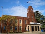
Rockdale was known by Europeans as Frog Hollow, then White Gum Flat and later West Botany. West Botany Municipality was declared 13 January 1871 and had two wards, West Botany and Arncliffe. A council chambers was built in 1872 on Rocky Point Road, Arncliffe and was used until 1888 when a new building was erected on the site of the present Rockdale Town Hall, which was then demolished and rebuilt after World War 2.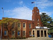
Banksia
Banksia is a genus of around 170 species in the plant family Proteaceae. These Australian wildflowers and popular garden plants are easily recognised by their characteristic flower spikes and fruiting "cones" and heads. When it comes to size, banksias range from prostrate woody shrubs to trees up...
. Until 1949, an electric tramway
Trams in Sydney
The Sydney tramway network once served Sydney, the capital city of New South Wales, Australia. In its heyday, it was the largest in Australia, the second largest in the Commonwealth , and one of the largest in the world. It was extremely intensively worked, with about 1,600 cars in service at any...
operated between Rockdale Station down Bay Street to Brighton-Le-Sands
Brighton-Le-Sands, New South Wales
Brighton-Le-Sands , is a suburb in southern Sydney, in the state of New South Wales, Australia. Brighton-Le-Sands is located 13 kilometres south of the Sydney central business district, on the western shore of Botany Bay...
. In 1948, Rockdale and Bexley councils amalgamated as Rockdale Municipal Council. The City of Rockdale
City of Rockdale
The City of Rockdale is a Local Government Area in southern Sydney, in the state of New South Wales, Australia. The city centre is located 12 kilometres south-south-west of the Sydney central business district, on the western shores of Botany Bay...
was declared in 1995.
Commercial area
Rockdale has a mixture of residential, commercial and light industrial areas. The main shopping strip runs along the Princes Highway, on the eastern side of Rockdale railway station. The commercial centre spreads out into surrounding streets and on the western side of the railway line. King Street has developed into a cosy strip of cafes and grocery shops. Commercial developments run along the length of theparts of Bay Street and West Botany Street. The light industrial areas are located around West Botany Street.Rockdale Plaza
Rockdale Plaza
Rockdale Plaza is a shopping centre managed by City Freeholds Pty. Ltd. in Rockdale, a suburb of Sydney, New South Wales, Australia. It features a number of major retailers and about 50 specialty shops...
, which opened in 1997, is a medium sized shopping centre located on Princes Highway. It contains two supermarkets, two discount department stores, a motor registry, a medical centre, a food court, real estate agent, sports store, electrical appliance store, video rental shop and specialty shops. It was built on the former site of the Waltons
Waltons (department store)
Waltons was an Australian department store chain, founded by Sir John Robert Walton.-History:Walton bought a menswear store in 1951, located in George St, Sydney, opposite the Queen Victoria Building and Sydney Town Hall and close to Town Hall railway station.In 1955, he formed an alliance with the...
department store and tenpin bowling centre.
Rockdale Town Hall and the St George Tavern are examples of some of the Art Deco
Art Deco
Art deco , or deco, is an eclectic artistic and design style that began in Paris in the 1920s and flourished internationally throughout the 1930s, into the World War II era. The style influenced all areas of design, including architecture and interior design, industrial design, fashion and...
architecture in the area.
Population
According to the 2006 Australian Bureau of StatisticsAustralian Bureau of Statistics
The Australian Bureau of Statistics is Australia's national statistical agency. It was created as the Commonwealth Bureau of Census and Statistics on 8 December 1905, when the Census and Statistics Act 1905 was given Royal assent. It had its beginnings in section 51 of the Constitution of Australia...
Census
Census
A census is the procedure of systematically acquiring and recording information about the members of a given population. It is a regularly occurring and official count of a particular population. The term is used mostly in connection with national population and housing censuses; other common...
of Population, there were 13,901 people usually resident in Rockdale. 53.2% stated they were born overseas with the top countries of birth being China 9.5%, Macedonia 5.2%, and Bangladesh 3.7%. English was stated as the only language spoken at home by 29.9% of residents and the most common other languages spoken were Macedonian 15.7%, Mandarin 7.2% and Arabic 7.2%. The most common responses for religious affiliation were Catholic
Roman Catholic Church
The Catholic Church, also known as the Roman Catholic Church, is the world's largest Christian church, with over a billion members. Led by the Pope, it defines its mission as spreading the gospel of Jesus Christ, administering the sacraments and exercising charity...
22.8%, Orthodox
Eastern Orthodox Church
The Orthodox Church, officially called the Orthodox Catholic Church and commonly referred to as the Eastern Orthodox Church, is the second largest Christian denomination in the world, with an estimated 300 million adherents mainly in the countries of Belarus, Bulgaria, Cyprus, Georgia, Greece,...
16.1% and Islam
Islam
Islam . The most common are and . : Arabic pronunciation varies regionally. The first vowel ranges from ~~. The second vowel ranges from ~~~...
10.1%.
Politics
- Federal Government: Rockdale is in the Division of BartonDivision of BartonThe Division of Barton is an Australian Electoral Division in New South Wales. The division was created in 1922 and is named for Sir Edmund Barton, the first Prime Minister of Australia...
in the Australian House of RepresentativesAustralian House of RepresentativesThe House of Representatives is one of the two houses of the Parliament of Australia; it is the lower house; the upper house is the Senate. Members of Parliament serve for terms of approximately three years....
. - State government: Rockdale is in the Electoral district of RockdaleElectoral district of RockdaleRockdale is an electoral district of the Legislative Assembly in the Australian state of New South Wales. It is represented by John Flowers of the Liberal Party of Australia.-History:...
in the New South Wales Legislative AssemblyNew South Wales Legislative AssemblyThe Legislative Assembly, or lower house, is one of the two chambers of the Parliament of New South Wales, an Australian state. The other chamber is the Legislative Council. Both the Assembly and Council sit at Parliament House in the state capital, Sydney...
. - Local Government: Rockdale is in the local government area of the City of RockdaleCity of RockdaleThe City of Rockdale is a Local Government Area in southern Sydney, in the state of New South Wales, Australia. The city centre is located 12 kilometres south-south-west of the Sydney central business district, on the western shores of Botany Bay...
.
Transport
The Princes HighwayPrinces Highway
The Princes Highway extends from Sydney to Port Augusta via the coast through the states of New South Wales, Victoria and South Australia, a distance of 1941 km or 1898 km via the former alignments of the highway ....
is the main road through Rockdale. West Botany Street, to the east, runs parallel to Princes Highway. Bay Street links Rockdale to General Holmes Drive at Brighton-le-Sands
Brighton-Le-Sands, New South Wales
Brighton-Le-Sands , is a suburb in southern Sydney, in the state of New South Wales, Australia. Brighton-Le-Sands is located 13 kilometres south of the Sydney central business district, on the western shore of Botany Bay...
. Rockdale railway station is on the Illawarra line of the City Rail network. Rockdale is a major bus interchange for Sydney Buses government buses, which provides services to Miranda
Miranda, New South Wales
Miranda is a suburb in southern Sydney, in the state of New South Wales, Australia. Miranda is located 24 kilometres south of the Sydney central business district, in the Sutherland Shire....
, Brighton-Le-Sands
Brighton-Le-Sands, New South Wales
Brighton-Le-Sands , is a suburb in southern Sydney, in the state of New South Wales, Australia. Brighton-Le-Sands is located 13 kilometres south of the Sydney central business district, on the western shore of Botany Bay...
, Dulwich Hill
Dulwich Hill, New South Wales
Dulwich Hill is a residential suburb in the Inner West of Sydney, in the state of New South Wales, Australia. Dulwich Hill is located 9 kilometres south-west of the Sydney central business district, in the local government area of Marrickville Council...
, Burwood
Burwood, New South Wales
Burwood is a suburb in the inner-west of Sydney, in the state of New South Wales, Australia. Burwood is located 12 kilometres west of the Sydney central business district and is the administrative centre for the local government area of Burwood Council....
and Bondi Junction
Bondi Junction, New South Wales
Bondi Junction is an eastern suburb of Sydney, in the state of New South Wales, Australia. Bondi Junction is located 6 kilometres east of the Sydney central business district and is part of the local government area of the Waverley....
.
Rockdale to Brighton-Le-Sands tram line
This line opened as a private steam tramway in 1885. It was electrified in 1900, and moved into government ownership in 1914. The line connected with the trains at Rockdale station, then passed down Bay Street to Brighton-Le-Sands
Brighton-Le-Sands, New South Wales
Brighton-Le-Sands , is a suburb in southern Sydney, in the state of New South Wales, Australia. Brighton-Le-Sands is located 13 kilometres south of the Sydney central business district, on the western shore of Botany Bay...
. The line was single track throughout, with a passing loop at each end. The line closed in 1949 and was replaced by a bus service. A small depot in Rockdale maintained the cars.