
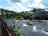
River Dee, Wales
Overview
River
A river is a natural watercourse, usually freshwater, flowing towards an ocean, a lake, a sea, or another river. In a few cases, a river simply flows into the ground or dries up completely before reaching another body of water. Small rivers may also be called by several other names, including...
in the United Kingdom. It travels through Wales
Wales
Wales is a country that is part of the United Kingdom and the island of Great Britain, bordered by England to its east and the Atlantic Ocean and Irish Sea to its west. It has a population of three million, and a total area of 20,779 km²...
and England
England
England is a country that is part of the United Kingdom. It shares land borders with Scotland to the north and Wales to the west; the Irish Sea is to the north west, the Celtic Sea to the south west, with the North Sea to the east and the English Channel to the south separating it from continental...
and also forms part of the border between the two countries.
The river rises in Snowdonia
Snowdonia
Snowdonia is a region in north Wales and a national park of in area. It was the first to be designated of the three National Parks in Wales, in 1951.-Name and extent:...
, Wales, flows east via Chester
Chester
Chester is a city in Cheshire, England. Lying on the River Dee, close to the border with Wales, it is home to 77,040 inhabitants, and is the largest and most populous settlement of the wider unitary authority area of Cheshire West and Chester, which had a population of 328,100 according to the...
, England, and discharges to the sea into an estuary between Wales and the Wirral Peninsula
Wirral Peninsula
Wirral or the Wirral is a peninsula in North West England. It is bounded by three bodies of water: to the west by the River Dee, forming a boundary with Wales, to the east by the River Mersey and to the north by the Irish Sea. Both terms "Wirral" and "the Wirral" are used locally , although the...
in England.
The total catchment area
Drainage basin
A drainage basin is an extent or an area of land where surface water from rain and melting snow or ice converges to a single point, usually the exit of the basin, where the waters join another waterbody, such as a river, lake, reservoir, estuary, wetland, sea, or ocean...
of the River Dee up to Chester Weir
Chester Weir
Chester Weir is a weir which crosses the River Dee at Chester, Cheshire, England, slightly upstream from the Old Dee Bridge . The weir and the associated salmon leap have been designated by English Heritage as a Grade I listed building....
is 1816.8 square kilometres (701.5 sq mi).
The average rainfall over the catchment is estimated to be 640 millimetres (25.2 in) yielding an average flow of 37 m³/s.
The larger reservoirs in the catchment
Drainage basin
A drainage basin is an extent or an area of land where surface water from rain and melting snow or ice converges to a single point, usually the exit of the basin, where the waters join another waterbody, such as a river, lake, reservoir, estuary, wetland, sea, or ocean...
are:
- Bala Lake (Llyn Tegid)Bala LakeBala Lake is a large lake in Gwynedd, Wales. It was the largest natural body of water in Wales prior to the level being raised by Thomas Telford to help support the flow of the Ellesmere Canal. It is long by wide, and is subject to sudden and dangerous floods. The River Dee runs through it and...
- 400 acres (1.6 km²) - Llyn BrenigLlyn BrenigLlyn Brenig is a reservoir located in North Wales, in the heart of the Denbigh Moors, on the border between the counties of Conwy and Denbighshire...
- 370 acres (1.5 km²) - Llyn CelynLlyn CelynLlyn Celyn is a large reservoir constructed between 1960 and 1965 in the valley of the River Tryweryn in Gwynedd, North Wales. It measures roughly 2½ miles long by a mile wide, and has a maximum depth of...
- 325 acres (1.3 km²)
The River Dee has its source on the slopes of Dduallt
Dduallt
Dduallt is a mountain in central Snowdonia, North Wales. It is the sister peak of Rhobell Fawr.It lies north of the A494 between Dolgellau and Llanuwchllyn. Its eastern slopes are the source of the River Dee.-External links:* Dduallt is at coordinates *...
above Llanuwchllyn
Llanuwchllyn
Llanuwchllyn is a village in Gwynedd, Wales, near the southern end of Bala Lake . Its population according to the United Kingdom Census 2001 was 834., of which approximately 81% were Welsh-speaking....
in the mountains of Snowdonia
Snowdonia
Snowdonia is a region in north Wales and a national park of in area. It was the first to be designated of the three National Parks in Wales, in 1951.-Name and extent:...
in Merioneth
Merionethshire
Merionethshire is one of thirteen historic counties of Wales, a vice county and a former administrative county.The administrative county of Merioneth, created under the Local Government Act 1888, was abolished under the Local Government Act 1972 on April 1, 1974...
, Gwynedd
Gwynedd
Gwynedd is a county in north-west Wales, named after the old Kingdom of Gwynedd. Although the second biggest in terms of geographical area, it is also one of the most sparsely populated...
, Wales
Wales
Wales is a country that is part of the United Kingdom and the island of Great Britain, bordered by England to its east and the Atlantic Ocean and Irish Sea to its west. It has a population of three million, and a total area of 20,779 km²...
, and then passes through Bala Lake
Bala Lake
Bala Lake is a large lake in Gwynedd, Wales. It was the largest natural body of water in Wales prior to the level being raised by Thomas Telford to help support the flow of the Ellesmere Canal. It is long by wide, and is subject to sudden and dangerous floods. The River Dee runs through it and...
.
Unanswered Questions