

Railway stations in Eritrea
Encyclopedia
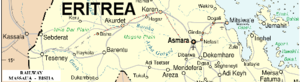
Eritrea
Eritrea , officially the State of Eritrea, is a country in the Horn of Africa. Eritrea derives it's name from the Greek word Erethria, meaning 'red land'. The capital is Asmara. It is bordered by Sudan in the west, Ethiopia in the south, and Djibouti in the southeast...
.
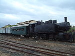
The Eritrean Railway
Eritrean Railway
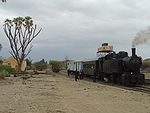
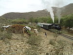
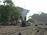
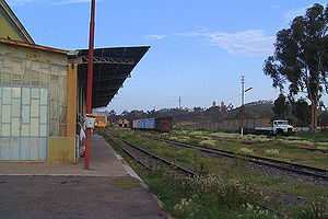
The Eritrean Railway is the only railway system in Eritrea. It was constructed between 1887 and 1932 by the Kingdom of Italy for the Italian colony of Eritrea, and connected the port of Massawa with Bishia near the Sudan border. The line was essentially destroyed by warfare in subsequent decades,...
originally ran from Massawa
Massawa
Massawa, also known as Mitsiwa Massawa, also known as Mitsiwa Massawa, also known as Mitsiwa (Ge'ez ምጽዋዕ , formerly ባጽዕ is a city on the Red Sea coast of Eritrea. An important port for many centuries, it was ruled by a succession of polities, including the Axumite Empire, the Umayyad Caliphate,...
, a port on the Red Sea
Red Sea
The Red Sea is a seawater inlet of the Indian Ocean, lying between Africa and Asia. The connection to the ocean is in the south through the Bab el Mandeb strait and the Gulf of Aden. In the north, there is the Sinai Peninsula, the Gulf of Aqaba, and the Gulf of Suez...
, via the capital Asmara
Asmara
Asmara is the capital city and largest settlement in Eritrea, home to a population of around 579,000 people...
to Agordat
Agordat
Agordat is a city in Eritrea. It was the former capital of the now defunct Barka Province of Eritrea .- Overview :...
. The line can be divided into three sections.
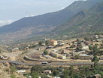
Massawa to Asmara
The route was built between 1887 and 1910 by the ItaliansItalian Eritreans
Italian Eritreans are Eritrean-born descendants of Italian settlers as well as Italian long-term residents in Eritrea.-History:...
, who made the two main stations (Asmara and Massawa) with typical structures of railway stations in small Italian cities.
As of 2008, this is the only section open.
| Name | Image | Altitude | Coordinates | |
|---|---|---|---|---|
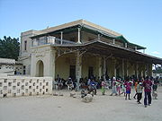
| Massawa Massawa Massawa, also known as Mitsiwa Massawa, also known as Mitsiwa Massawa, also known as Mitsiwa (Ge'ez ምጽዋዕ , formerly ባጽዕ is a city on the Red Sea coast of Eritrea. An important port for many centuries, it was ruled by a succession of polities, including the Axumite Empire, the Umayyad Caliphate,... |
 |
0 km (0 mi) | 3 m (10 ft) | 15.606546°N 39.466163°E |
| Campo de Marte | 2.8 km (1.7 mi) | 9 m (30 ft) | ||
| Otumlo | 4.6 km (2.9 mi) | 11 m (36 ft) | ||
| Moncullo | 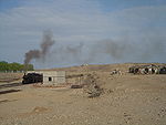 |
7.7 km (4.8 mi) | 30 m (98 ft) | 15.61041°N 39.408839°E |
| Dogali Dogali Dogali is a town in eastern Eritrea. Situated near Massawa, it became famous for the Battle of Dogali in 1887-01-24 between Italy and Ethiopia.... |
 |
19.6 km (12.2 mi) | 100 m (328 ft) | |
| Mai Atal | 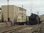 |
29.4 km (18.3 mi) | 181 m (594 ft) | 15.568268°N 39.242767°E |
| Damas | 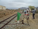 |
45 km (28 mi) | 416 m (1,365 ft) | 15.476202°N 39.207952°E |
| Baresa Baresa, Eritrea Baresa is a small town located in the Northern Red Sea region of Eritrea. It lies between Asmara and Massawa, not too far from Ghinda.-References:*-External links:*... |
 |
57.1 km (35.5 mi) | 600 m (1,969 ft) | 15.401421°N 39.184778°E |
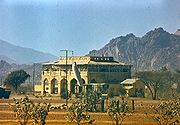
| Ghinda Ghinda Ghinda is a town in the Northern Red Sea region of Eritrea. It lies between Asmara and Massawa.-Overview:Ghinda is a major fruit and vegetable growing area and a centre for Tigre Muslims. It lies near the springs of Sabarguma... |
 |
69.4 km (43.1 mi) | 888 m (2,913 ft) | 15.438634°N 39.101447°E |
| Embatkalla | 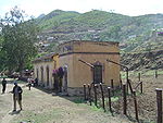 |
81.1 km (50.4 mi) | 1274 m (4,180 ft) | 15.400438°N 39.07397°E |
| Nefasit Nefasit Nefasit is a small town in the Northern Red Sea Region of Eritrea. Historically it was an important slave trading port.... |
 |
93 km (57.8 mi) | 1672 m (5,486 ft) | 15.335212°N 39.063274°E |
| Arbaroba | 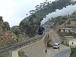 |
104.9 km (65.2 mi) | 2064 m (6,772 ft) | 15.346758°N 39.007419°E |
| Asmara Asmara Asmara is the capital city and largest settlement in Eritrea, home to a population of around 579,000 people... |
 |
117.6 km (73.1 mi) | 2342 m (7,684 ft) | 15.338936°N 38.949323°E |
Asmara to Keren
| Name | Distance | Altitude |
|---|---|---|
| Tzada Cristian | 127.2 km (79 mi) | 2292 m (7,520 ft) |
| Zazzega | 136.8 km (85 mi) | 2217 m (7,274 ft) |
| Dem Sabai | 148.5 km (92.3 mi) | 1988 m (6,522 ft) |
| Andenna | 156.6 km (97.3 mi) | 1907 m (6,257 ft) |
| Abrascico | 164.9 km (102.5 mi) | 1783 m (5,850 ft) |
| Amba Derho | 176.3 km (109.5 mi) | 1688 m (5,538 ft) |
| Furkuto | 185.7 km (115.4 mi) | 1635 m (5,364 ft) |
| Elabered | 195.3 km (121.4 mi) | 1468 m (4,816 ft) |
| Halib Mentel Halib Mentel Halib Mentel, also referred to as Halibmentel or Halimentel, is a village in Eritrea. It is located approximately east of the city of Keren.-Overview:... |
209.9 km (130.4 mi) | 1423 m (4,669 ft) |
| Keren Keren, Eritrea Keren is the second largest city in Eritrea. It is situated about 91 kilometers northwest of Asmara. The town serves as the capital of the Anseba region, and is home to the Bilen ethnic group.-History:... |
221.7 km (137.8 mi) | 1390 m (4,560 ft) |
Keren to Agordat
| Name | Distance | Altitude |
|---|---|---|
| Asciadira | 232.7 km (144.6 mi) | 1204 m (3,950 ft) |
| Hummed | 245.7 km (152.7 mi) | 935 m (3,068 ft) |
| Agat | 253.3 km (157.4 mi) | 864 m (2,835 ft) |
| Darotai | 262.5 km (163.1 mi) | 795 m (2,608 ft) |
| Mai Adarte | 271.4 km (168.6 mi) | 750 m (2,461 ft) |
| Umfutat | 284.6 km (176.8 mi) | 669 m (2,195 ft) |
| Carobel | 296.4 km (184.2 mi) | 677 m (2,221 ft) |
| Agordat Agordat Agordat is a city in Eritrea. It was the former capital of the now defunct Barka Province of Eritrea .- Overview :... |
306.4 km (190.4 mi) | 606 m (1,988 ft) |
Beyond Agordat
Beyond Agordat, the rails were laid as far as BishiaBishia
- Transport :It is the end of the railway line from Asmara, though the line did briefly extend through to Sudan.- References :...
, another 31 kilometres (19.3 mi), with plans to extend to Ellit
Ellit
-Overview:The city is situated on the road between Agordat and Teseney.In the 1920s, design work was carried out to extend the railway from Asmara through Ellit to Teseney and Sudan, but work stalled.-External links:**...
and Teseney
Teseney
Teseney , also spelled Tessenei or Tesseney, is a market town in western Eritrea. It lies south-east of Kassala in Sudan, on the Gash River. The city was much fought over in the Eritrean War of Independence during which much of it was destroyed...
, linking with the railway network in Sudan
Sudan
Sudan , officially the Republic of the Sudan , is a country in North Africa, sometimes considered part of the Middle East politically. It is bordered by Egypt to the north, the Red Sea to the northeast, Eritrea and Ethiopia to the east, South Sudan to the south, the Central African Republic to the...
. However this section was never completed.
There would have been a break-of-gauge
Break-of-gauge
With railways, a break-of-gauge occurs where a line of one gauge meets a line of a different gauge. Trains and rolling stock cannot run through without some form of conversion between gauges, and freight and passengers must otherwise be transloaded...
at the connection between Sudan and Eritrea.
| Name | Distance | Altitude | Comments |
|---|---|---|---|
| Agordat Agordat Agordat is a city in Eritrea. It was the former capital of the now defunct Barka Province of Eritrea .- Overview :... |
232.7 km (144.6 mi) | 606 m (1,988 ft) | |
| Bishia Bishia - Transport :It is the end of the railway line from Asmara, though the line did briefly extend through to Sudan.- References :... |
263.7 km (163.9 mi) | 715 m (2,346 ft) | |
| Ellit Ellit -Overview:The city is situated on the road between Agordat and Teseney.In the 1920s, design work was carried out to extend the railway from Asmara through Ellit to Teseney and Sudan, but work stalled.-External links:**... |
290.7 km (180.6 mi) | 735 m (2,411 ft) | km uncertain |
| Teseney Teseney Teseney , also spelled Tessenei or Tesseney, is a market town in western Eritrea. It lies south-east of Kassala in Sudan, on the Gash River. The city was much fought over in the Eritrean War of Independence during which much of it was destroyed... |
301 km (187 mi) | 600 m (1,969 ft) | km uncertain |
 Kassala KassalaKassala Kassala is the capital of the state of Kassala in eastern Sudan. Its 2008 population was recorded to be 419,030. It is a market town and is famous for its fruit gardens. It was formerly a railroad hub, however, as of 2006 there was no operational railway station in Kassala and much of the track... , Sudan |
351 km (218.1 mi) | 531 m (1,742 ft) | km uncertain; Near Eritrea-Sudan border |
Potash railway
A 42 kilometres (26.1 mi) line carrying potashPotash
Potash is the common name for various mined and manufactured salts that contain potassium in water-soluble form. In some rare cases, potash can be formed with traces of organic materials such as plant remains, and this was the major historical source for it before the industrial era...
was built to serve the following locations:
- Badda
- Adaito
See also
- Transport in EritreaTransport in EritreaThis article summarizes characteristics of a number of forms of transport in the coastal African nation of Eritrea.- Railways :As of 1999, there was a total of 317 kilometres of rail line in Eritrea...
- Eritrean RailwayEritrean RailwayThe Eritrean Railway is the only railway system in Eritrea. It was constructed between 1887 and 1932 by the Kingdom of Italy for the Italian colony of Eritrea, and connected the port of Massawa with Bishia near the Sudan border. The line was essentially destroyed by warfare in subsequent decades,...
- Italian EritreansItalian EritreansItalian Eritreans are Eritrean-born descendants of Italian settlers as well as Italian long-term residents in Eritrea.-History:...
- Railway stations in SudanRailway stations in SudanRailway stations in Sudan include:- Maps :* * - Existing :* Wadi Halfa - N - potential break-of-gauge with Egypt** Merowe** Karima - branch terminus on River Nile - N* Abu Hamed - N junction for Karima* Barbar* Atbara - N - junction and workshops...