
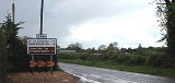
R444 road
Encyclopedia
Regional road
A regional road in Ireland is a class of road not forming a major route , but nevertheless forming a link in the national route network. There are over 11,600 kilometres of regional roads. Regional roads are numbered with three digit route numbers, prefixed by "R" A regional road in Ireland is a...
in Ireland
Republic of Ireland
Ireland , described as the Republic of Ireland , is a sovereign state in Europe occupying approximately five-sixths of the island of the same name. Its capital is Dublin. Ireland, which had a population of 4.58 million in 2011, is a constitutional republic governed as a parliamentary democracy,...
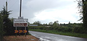
linking R357
R357 road
The R357 road is a regional road in Ireland linking Athleague, County Roscommon and Blue Ball, County Offaly. It passes Ballinasloe, County Galway, crosses the River Shannon at Shannonbridge passes through Cloughan, County Offaly and then through the cutaway peatlands of Boora Bog to Blue Ball...
at Shannonbridge
Shannonbridge
Shannonbridge is a village located on the River Shannon, at the junction of the R444 and R357 regional roads in County Offaly, Ireland. It lies within the townland of Raghra , at the borders of counties Offaly, Galway and Roscommon, with the majority of the population living east of the bridge in...
, County Offaly
County Offaly
County Offaly is a county in Ireland. It is part of the Midlands Region and is also located in the province of Leinster. It is named after the ancient Kingdom of Uí Failghe and was formerly known as King's County until the establishment of the Irish Free State in 1922. Offaly County Council is...
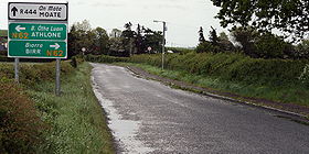
with the N6 at Farnagh three kilometers west of Moate
Moate
Moate is a town in County Westmeath, Ireland.The name An Móta is derived from the term motte-and-bailey as the Normans built an example of this type of fortification here. The earthwork is still visible behind the buildings on the main street....
in County Westmeath
County Westmeath
-Economy:Westmeath has a strong agricultural economy. Initially, development occurred around the major market centres of Mullingar, Moate, and Kinnegad. Athlone developed due to its military significance, and its strategic location on the main Dublin–Galway route across the River Shannon. Mullingar...
.
The road is 27 km (16.8 mi) long.