
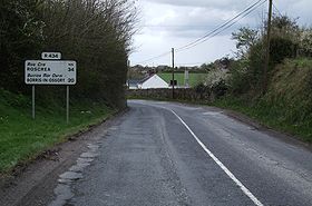
R434 road
Encyclopedia
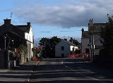
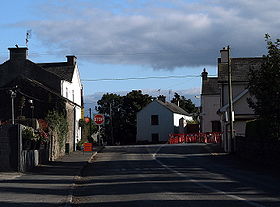
The R434 road is a regional road
in Ireland
linking Borris-in-Ossory
on the N7 national primary road
to Durrow
on the R639
. En route it passes through Aghaboe
and Ballycolla
, and over both the M7 and M8
motorways. The entire route is within County Laois
.
The R434 was the former Trunk Road, T48
.
The road is 20 km (12.4 mi) long.
Regional road
A regional road in Ireland is a class of road not forming a major route , but nevertheless forming a link in the national route network. There are over 11,600 kilometres of regional roads. Regional roads are numbered with three digit route numbers, prefixed by "R" A regional road in Ireland is a...
in Ireland
Republic of Ireland
Ireland , described as the Republic of Ireland , is a sovereign state in Europe occupying approximately five-sixths of the island of the same name. Its capital is Dublin. Ireland, which had a population of 4.58 million in 2011, is a constitutional republic governed as a parliamentary democracy,...
linking Borris-in-Ossory
Borris-in-Ossory
Borris-in-Ossory is a village in west County Laois, Ireland. Bypassed by the M7 motorway on 28 May, 2010, the village is situated on the R445 road close to the County Tipperary border between the towns of Mountrath and Roscrea.-Features:...
on the N7 national primary road
National primary road
A national primary road is a road classification in the Republic of Ireland. National primary roads form the major routes between the major urban centres. There are over 2,700km of national primary roads. This category of road has the prefix "N" followed by one or two digits...
to Durrow
Durrow
Durrow is a small rural village in County Offaly, Ireland. Durrow is located on the N52 off the N6 road between Kilbeggan and Tullamore .Famous for being the Ancestral home of the Champion ploughman Luke Bracken. and Dean McDermott, Offaly Bord na Scol runner up,...
on the R639
R639 road
The R639 road is one of Ireland's regional roads. Once designated the N8 national primary road , it was reclassified in stages as the R639 following the progressive opening of sections of the M8 motorway, which rendered the single carriageway N8 redundant as a national primary road...
. En route it passes through Aghaboe
Aghaboe
Aghaboe is a village and parish in County Laois, Ireland. It is located on the R434 regional road in the rural hinterland west of the town of Abbeyleix....
and Ballycolla
Ballycolla
Ballacolla, officially Ballycolla , is a village in County Laois, Ireland. It sits at the crossroads of the R433 and R434 regional roads, southwest of Abbeyleix and 4km northeast of junction 3 of the M8 motorway....
, and over both the M7 and M8
M8 motorway (Ireland)
The M8 motorway is an inter-urban motorway in Ireland, which forms part of the road from the capital - Dublin - to Cork city. The 149 km motorway commences in the townland of Aghaboe, County Laois and runs through the counties of Kilkenny, North Tipperary, South Tipperary and Limerick,...
motorways. The entire route is within County Laois
County Laois
County Laois is a county in Ireland. It is part of the Midlands Region and is also located in the province of Leinster. It was formerly known as Queen's County until the establishment of the Irish Free State in 1922. The county's name was formerly spelt as Laoighis and Leix. Laois County Council...
.
The R434 was the former Trunk Road, T48
Trunk Roads in Ireland
Ireland has an extensive network of public roads which connect all parts of the country with each other. Roads in Ireland are currently classified as motorways, National Primary routes, National secondary routes, Regional roads and Local roads. The introduction of this classification system began...
.
The road is 20 km (12.4 mi) long.