
Quebradillas, Puerto Rico
Encyclopedia
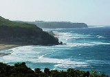
Quebradillas is a municipality of the island of Puerto Rico
Puerto Rico
Puerto Rico , officially the Commonwealth of Puerto Rico , is an unincorporated territory of the United States, located in the northeastern Caribbean, east of the Dominican Republic and west of both the United States Virgin Islands and the British Virgin Islands.Puerto Rico comprises an...
, located in the north-western shore bordering the Atlantic Ocean
Atlantic Ocean
The Atlantic Ocean is the second-largest of the world's oceanic divisions. With a total area of about , it covers approximately 20% of the Earth's surface and about 26% of its water surface area...
, north of San Sebastián
San Sebastián, Puerto Rico
San Sebastián is a municipality of Puerto Rico located northwest of the island south of Isabela and Quebradillas; north of Las Marías; east of Moca and Añasco; and west of Lares. San Sebastián is spread over twenty-four wards and San Sebastián Pueblo...
; east of Isabela
Isabela, Puerto Rico
Isabela is a municipality of Puerto Rico located in the north-western region of the island, north of San Sebastián; west of Quebradillas; and east of Aguadilla and Moca. Isabela is spread over 13 wards and Isabela Pueblo...
; and west of Camuy
Camuy, Puerto Rico
Camuy is a municipality in Puerto Rico located on the Valley of Quebradillas, bordering the Atlantic Ocean, north of Lares; east of Quebradillas; and west of Hatillo. Camuy is spread over 12 wards and Camuy Pueblo...
. Quebradillas is spread over swven wards and Quebradillas Pueblo (The downtown area and the administrative center of the city). It is part of the San Juan-Caguas-Guaynabo Metropolitan Statistical Area.
Quebradillas is called "La Guarida del Pirata" (The Pirate's Hideout). A well known beach in the area, Puerto Hermina, is home to an old structure known to have been a hiding place for pirates and their contraband.
History
The town was founded in 1823 by Felipe Ruiz. This town derives its name from the large amount of streams flowing through it. The name literally means "small streams".Flag
It has two red quarters. The red stands for struggle, effort and sacrifice. The other two quarters have each five green and white stripes, similar to those that appear in the shield.Coat of Arms
The three waved stripes represent the quebradillas, over the green background of the vegetation. The fish and the walking stick (distinctive of the traveler), are insignias of San Rafael Arcángel, by allusion from the episodes narrated in the book of Tobías in the Old Testament.Barrios (Districts/Wards)
- Cacao
- Charcas
- Cocos
- Guajataca
- Quebradillas Pueblo
- San Antonio
- San José
- Terranova
Geography
Quebradillas is home to one of the 20 designated forest preserves in Puerto Rico, the Guajataca Forest. The forest serves as a great example of an unusual topography known as karst countryKARST
Kilometer-square Area Radio Synthesis Telescope is a Chinese telescope project to which FAST is a forerunner. KARST is a set of large spherical reflectors on karst landforms, which are bowlshaped limestone sinkholes named after the Kras region in Slovenia and Northern Italy. It will consist of...
. Karst is characterized by dissolved limestone formations such as sinkholes and haystack-shaped hills known as "mogotes"
Mogote
Mogotes are isolated, steep-sided, residual, hills, which are composed of either limestone, marble, or dolomite and surrounded by nearly flat alluvial plains. These hills typically have a rounded, tower-like form. This term was originally used for karst hills developed in the folded limestone in...
. It is also home to the beautiful man-made reservoir, Guajataca Lake
Guajataca Lake
Lago Guajataca is a reservoir located between the municipalities of San Sebastián, Quebradillas, and Isabela in Puerto Rico. This man-made lake was created in 1929....
(2.5 mi/4 km long), where you can fish for largemouth bass, peacock bass, tilapia and bluegill (in Spanish known as "chopa"). You can also go hiking or camping. The Boy Scouts of America
Scouting in Puerto Rico
Scouting in Puerto Rico has a long history, from the 1920s to the present day, serving both boys and girls. Troops, Venturing Crews and Sea Scouting units are part of the Boy Scouts of America, for both boys and girls, or the Girl Scouts of the USA, for girls...
maintain a campground on the lake known as Camp Guajataca. The name Guajataca comes from the name of a Taíno
Taíno people
The Taínos were pre-Columbian inhabitants of the Bahamas, Greater Antilles, and the northern Lesser Antilles. It is thought that the seafaring Taínos are relatives of the Arawak people of South America...
Indian chief who lived in this area. This Indian chief also gives his name to Guajataca Beach to the north where Río Guajataca flowing from Guajataca Lake meets the Atlantic Ocean. Guajataca Beach is popular with surfers and is known for its white sands and wild waters. This beach is ideal for sunning and collecting seashells.
Business
A small shopping center called Quebradillas Plaza is located in this municipality along with some manufacturing industries.An event that marked negatively in the decade of 1990s was the disappearance of the tax exemptions to the private corporations [section 936 of the code of the US Internal Revenue Service
Internal Revenue Service
The Internal Revenue Service is the revenue service of the United States federal government. The agency is a bureau of the Department of the Treasury, and is under the immediate direction of the Commissioner of Internal Revenue...
], which at the time was the ideal excuse for the closing of one of the greater manufacturers of textiles in the northwest area of the island. This decline of the industry of the needle occurred similarly in the bordering cities like Isabela
Isabela, Puerto Rico
Isabela is a municipality of Puerto Rico located in the north-western region of the island, north of San Sebastián; west of Quebradillas; and east of Aguadilla and Moca. Isabela is spread over 13 wards and Isabela Pueblo...
and Camuy, generating a regional economic decline as the locals greatly depended on these jobs. In nearby towns like Hatillo
Hatillo, Puerto Rico
Hatillo is a municipality located on Puerto Rico's north coast, bordered by the Atlantic Ocean to the north, Lares and Utuado to the south, Camuy to the west, and Arecibo to the east. According to the 2000 US Census Hatillo is spread over 9 wards and Hatillo Pueblo...
, Mayagüez and Aguadilla, the arrival of megastores and new shopping centers attracted the jobs that used to be in Quebradillas, helping to create the general vision of the town as "ghostly" because there is little movement in the city.
At the same time, since the Island lacks mass public transportation, people must resort to private cars (although known as carro publico,public car in English) used as a bus as a mode of transportation, coupled with the fact that the only road to access the important cities, the Puerto Rico Highway 2
Puerto Rico Highway 2
Puerto Rico Highway 2, the longest highway in the Commonwealth of Puerto Rico at about 156 miles long, connects San Juan to Ponce....
, is maintained congested most of the day, makes it difficult for people in the area to find work and thus contributing to the general economic decline.
Ironically, the town possesses two tunnels that at the beginning of the 20th century were utilized by steam driven trains that traveled throughout the Island. The disappearance of the same is considered as one of the most ironic facts of the modern history of Puerto Rico, since these railways were very extensive, built through earthly bluffs and were of great utility. Today, its absence only aggravates the problem of mass transit and the dependence on privately owned vehicles as the only method of transportation.
The economy, entering into the 21st century, is based on the sale of retail. Many small businesses are located along the two main thoroughfares that cross Quebradillas. These consist mainly of light hardware, bakeries, pharmacies, seafood restaurants, American fast food chains near the center of town and workshops of automobile service.
It also contains branches of various banks including Banco Popular and local savings and credit cooperatives
Cooperative banking
Cooperative banking is retail and commercial banking organized on a cooperative basis. Cooperative banking institutions take deposits and lend money in most parts of the world....
. The cooperatives of savings and credit are most noted by their involvement in common and cultural activities, sponsoring and participating in festivals of typical music [Festival of the Gourd in December], sports and educational activities.
Landmarks and places of interest
- El Merendero (Scenic Park and Ocean Look-Out)
- Guajataca LakeGuajataca LakeLago Guajataca is a reservoir located between the municipalities of San Sebastián, Quebradillas, and Isabela in Puerto Rico. This man-made lake was created in 1929....
Reservoir (Inland) - Guajataca Beach and the Train TunnelGuajataca TunnelGuajataca Tunnel is a railroad tunnel that connected the town of Isabela and Quebradillas, Puerto Rico. The tunnel is one of the most significant work of the remnants of the national railway system that connected the island during the first half of the twentieth century. In 2000, the Government of...
- La Cabeza del Indio (Indian Head at Puerto Hermina Beach)
- The Old Liberty Theater (Downtown)
- Noah's Arc (Petting Zoo and Put-Put Golf) (ARCA DE NOÉ)
- Puerto Hermina Beach Pirate Ruins
- El Puente BlancoPuente BlancoPuente Blanco is a railway bridge that spans hundred and fifty feet deep and thirty six metres wide gorge across the Quebrada Mala Canyon, near Quebradillas, Puerto Rico. The bridge is the only reinforced concrete bridge in the area and the highest of its kind in Puerto Rico...
(Old White Train Bridge) - Monte Calvario (replica of Mount Calvary)
- Casa Rafols-Iribas, site of Casa de la Cultura Cacique Mabodamaca (non-profit organization dedicated to preserve the culture, the arts and the historical sites of the town of Quebradillas)
Festivals and events
- Three Kings Wake - January
- Kite Festival - February
- Guajataca Carnival - February
- Patron Celebrations - October
- Guajataka Beach Skateboard Downhill Races - January
Education
- High Schools
- Manuel Ramos Hernandez
- Juan Alejo de Arizmendi
- Private Schools
- Colegio San Rafael
- Public Schools
- Eugenio Maria De Hostos
- Luis Muñoz Rivera
- Honorio Hernandez
- Pedro Albizu Campos
- Elementary Schools
- Ramon E. Betancez
- Ramon Avila Molinari
- Ramon Saavedra
- Jose De Diego
Sports
- Basketball
- Surfing - Guajataca Beach and Puerto Hermina (Pirates Cove)
- Skateboarding -San Jose Skatepark
- Baseball - Los Cocos Park