

Pulau Manukan
Encyclopedia
Tunku Abdul Rahman National Park
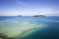
The Tunku Abdul Rahman Marine Park comprises a group of 5 islands located between 3 to 8 km off Kota Kinabalu. The park is spread over 4,929 hectares, two thirds of which cover the sea. Before the Ice Age, it formed part of the Crocker Range mass of sandstone and sedimentary rock on the mainland...
, Malaysia's first marine national park. It is located in the East Malaysia
East Malaysia
East Malaysia, also known as Malaysian Borneo, is the part of Malaysia located on the island of Borneo. It consists of the Malaysian states of Sabah and Sarawak, and the Federal Territory of Labuan. It lies to the east from Peninsular Malaysia , which is located on the Malay Peninsula. The two are...
n state of Sabah
Sabah
Sabah is one of 13 member states of Malaysia. It is located on the northern portion of the island of Borneo. It is the second largest state in the country after Sarawak, which it borders on its southwest. It also shares a border with the province of East Kalimantan of Indonesia in the south...
, just off the coast of Kota Kinabalu
Kota Kinabalu
Kota Kinabalu , formerly known as Jesselton, is the capital of Sabah state in East Malaysia. It is also the capital of the West Coast Division of Sabah. The city is located on the northwest coast of Borneo facing the South China Sea. The Tunku Abdul Rahman National Park lies on one side and Mount...
and is easily accessible by boat.
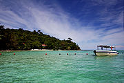
Manukan is the most popular island with Kota Kinabalu
Kota Kinabalu
Kota Kinabalu , formerly known as Jesselton, is the capital of Sabah state in East Malaysia. It is also the capital of the West Coast Division of Sabah. The city is located on the northwest coast of Borneo facing the South China Sea. The Tunku Abdul Rahman National Park lies on one side and Mount...
residents. Manukan has some good stretches of beaches on the southern coastline. The best beach is on the eastern tip of the island. Offshore of Manukan are coral reef
Coral reef
Coral reefs are underwater structures made from calcium carbonate secreted by corals. Coral reefs are colonies of tiny living animals found in marine waters that contain few nutrients. Most coral reefs are built from stony corals, which in turn consist of polyps that cluster in groups. The polyps...
s, which is ideal for snorkeling, diving and swimming.
Out of the 5 islands making up Tunku Abdul Rahman National Park
Tunku Abdul Rahman National Park
The Tunku Abdul Rahman Marine Park comprises a group of 5 islands located between 3 to 8 km off Kota Kinabalu. The park is spread over 4,929 hectares, two thirds of which cover the sea. Before the Ice Age, it formed part of the Crocker Range mass of sandstone and sedimentary rock on the mainland...
, Manukan features the most developed tourist facilities that includes 20 units of chalets, a clubhouse, and few restaurants and a diving centre. Recreation facilities include a swimming pool, football field, Volleyball and Sepak Takraw courts. Infrastructural facilities include support-water, electricity, desalination plant, sewerage
Sanitary sewer
A sanitary sewer is a separate underground carriage system specifically for transporting sewage from houses and commercial buildings to treatment or disposal. Sanitary sewers serving industrial areas also carry industrial wastewater...
system, and even a solar public telephone
Payphone
A payphone or pay phone is a public telephone, often located in a phone booth or a privacy hood, with pre-payment by inserting money , a credit or debit card, or a telephone card....
. It is covered in dense vegetation and has hiking trails.
Jesselton Point Ferry Terminal in downtown Kota Kinabalu
Kota Kinabalu
Kota Kinabalu , formerly known as Jesselton, is the capital of Sabah state in East Malaysia. It is also the capital of the West Coast Division of Sabah. The city is located on the northwest coast of Borneo facing the South China Sea. The Tunku Abdul Rahman National Park lies on one side and Mount...
is the ferry terminal for those heading to the islands in Tunku Abdul Rahman National Park
Tunku Abdul Rahman National Park
The Tunku Abdul Rahman Marine Park comprises a group of 5 islands located between 3 to 8 km off Kota Kinabalu. The park is spread over 4,929 hectares, two thirds of which cover the sea. Before the Ice Age, it formed part of the Crocker Range mass of sandstone and sedimentary rock on the mainland...
. This ferry terminal is also the departure point for patrons staying at the Manukan Island Resort.
History
Before the Ice Age, the island formed part of the Crocker Range mass of sandstone and sedimentary rock on the mainland. However, about one million years ago, the melting ice brought about changes in the sea level and parts of the mainland were cut off by the sea to form the islands of Gaya IslandPulau Gaya
Pulau Gaya is a sizeable Malaysian island of 1,465 ha, just 10 minutes off Kota Kinabalu, Sabah and forms part of the Tunku Abdul Rahman National Park. Pulau Gaya derived its name from the Bajau word "Gayo" which means big and occupies an area of 15 km² with an elevation of up to 300 metres...
, Sapi Island, Manukan Island, Mamutik Island and Sulug Island. Evidence of this can be seen from the exposed sandstone of the coastline forming the cliffs, caves, honeycombs and deep crevices.
Jesselton Point Ferry Terminal in downtown Kota Kinabalu is the ferry terminal for those heading to the islands in Tunku Abdul Rahman
Tunku Abdul Rahman
Tunku Abdul Rahman Putra Al-Haj ibni Almarhum Sultan Abdul Hamid Halim Shah, AC, CH was Chief Minister of the Federation of Malaya from 1955, and the country's first Prime Minister from independence in 1957. He remained as the Prime Minister after Sabah, Sarawak, and Singapore joined the...
Marine Park (Gaya Island, Sapi Island, Manukan Island, Mamutik Island and Sulug Island). This ferry terminal is also the departure point for patrons staying at either Manukan Island Resort or Gayana Resort.
In 1974, the major part of Pulau Gaya
Pulau Gaya
Pulau Gaya is a sizeable Malaysian island of 1,465 ha, just 10 minutes off Kota Kinabalu, Sabah and forms part of the Tunku Abdul Rahman National Park. Pulau Gaya derived its name from the Bajau word "Gayo" which means big and occupies an area of 15 km² with an elevation of up to 300 metres...
and Pulau Sapi was gazetted as Tunku Abdul Rahman National Park
Tunku Abdul Rahman National Park
The Tunku Abdul Rahman Marine Park comprises a group of 5 islands located between 3 to 8 km off Kota Kinabalu. The park is spread over 4,929 hectares, two thirds of which cover the sea. Before the Ice Age, it formed part of the Crocker Range mass of sandstone and sedimentary rock on the mainland...
, covering an area of 8990 acres (36.4 km²). In 1979, the park was increased to 12185 acres (49.3 km²) with the inclusion of the three nearby islands of Pulau Manukan, Pulau Mamutik and Pulau Sulug.