
Puerto Rico Highway 53
Encyclopedia
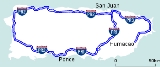
Puerto Rico Highway 53 is a main tollway that is parallel to Puerto Rico Highway 3
, which goes from Fajardo
to Salinas
. Some segments are still under construction, but when finished it will have about 59 miles (95 km) of length. Two tunnels, about 1 km (0.6 mi) long each, in the towns of Yabucoa
and Maunabo
were completed in . It will connect the cities of Fajardo, Ceiba
, Naguabo
, Humacao
, Yabucoa, Maunabo, Patillas
, Arroyo
, Guayama
and Salinas, thus bordering the entire eastern and southeastern coasts of Puerto Rico. Its northern terminus is at PR-3 and PR-194 in Fajardo, and its south terminus is at PR-52 in Salinas.
 The highway consists of five toll plazas; these are at Ceiba Norte, Humacao Norte, Humacao Sur (near Palmas del Mar), Guayama and Salinas. It is very probable that a final toll plaza before entering the future tunnels is added, and it might be the most expensive of all the toll plazas in the four main tollways (PR-52, PR-22 and PR-66) and possibly even more expensive than the toll plaza at the Teodoro Moscoso bridge ($2.00 per direction) because of the high cost of the construction of the tunnels.
All toll plazas, with the exception of the one located in Guayama (near km 80), have the Auto Expreso lanes.
Three phases of the tollway have been completed: the first one was from Salinas to Guayama, which is about 7.5 miles (12.1 km) long (milepost 83 to 95 km), the second from Fajardo to Yabucoa at 28 mi (45.1 km) (This includes an incomplete bridge in Yabucoa that does not fall into the high-speed highway classification in the interstate system as it is only one lane per direction and will require the addition of an additional bridge or constructing a bridge over the existing bridge, as it lies in a main corn and plantain field.) Recently 1.2 miles (1.9 km), between Yabucoa and Maunabo, includes the last tunnel, Vicente Morales, was opened in October 2008. The total constructed highways totals by this time is 34 miles (54.7 km), leaving nearly 25 miles (40.2 km) to be constructed in Yabucoa (including the other additional tunnel) and from Maunabo to Guayama which is the longest to-be-built segment. The lanes in the Yabucoa segments were divided by painted yellow lines and no-passing zone boards, but a concrete median barrier had to be installed because some cars still passed others that going slower with deadly collisions; illegal night races inalso had deadly consequences.
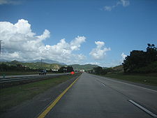
 PR-53 is the tollway with the lowest traffic in Puerto Rico, and very few congestion jams have been reported. PR-53 does not enter highly populated towns (none of them are over 100,000, the largest are Fajardo, Humacao and Guayama) and is not close to increase its traffic due to the fact that most of the population in the east part of Puerto Rico live in the San Juan metro area, Caguas and Cayey, cities where PR-53 makes no appearance; and the main traffic in Humacao is mostly located on the PR-30 and PR-60 highways. The center/business area of Humacao is accessed via PR-30 and PR-60, not by PR-53. Because of this, PR-53 has no more than two lanes per direction in the constructed segments and will probably have no more than two lanes per direction in the entire length.
PR-53 is also prone to flooding in the areas near Naguabo and Fajardo: during heavy rains, it is sometimes closed to traffic. There are current proposals to convert PR-3 from Rio Grande to Fajardo into a freeway to provide a controlled-access route between PR-53's northern terminus and the second phase of PR-66. At the rate of construction, the entire PR-53 corridor might be completed within the next ten years. The first segment of PR-53 was opened in 1994.
Puerto Rico Highway 3
Puerto Rico Highway 3 ' at nearly 101 miles long, is the second longest highway on Puerto Rico . It connects the San Juan neighborhood of Rio Piedras to downtown Salinas indirectly around the eastern coast of the island...
, which goes from Fajardo
Fajardo, Puerto Rico
Fajardo is a small city in Puerto Rico located in the east region of the island, bordering the Atlantic Ocean, north of Ceiba and east of Luquillo.Fajardo is spread over 7 wards and Downtown Fajardo , which serves as the administrative center of the city...
to Salinas
Salinas, Puerto Rico
Salinas is a small municipality in the southern part of Puerto Rico located in the southern coast of the island, south of Aibonito and Cayey; southeast of Coamo, east of Santa Isabel; and west of Guayama...
. Some segments are still under construction, but when finished it will have about 59 miles (95 km) of length. Two tunnels, about 1 km (0.6 mi) long each, in the towns of Yabucoa
Yabucoa, Puerto Rico
Yabucoa is a small town in the south eastern tip of Puerto Rico located in the southeastern region, north of Maunabo; south of San Lorenzo, Las Piedras and Humacao; and east of Patillas and about one hour from San Juan. Yabucoa is spread over 9 wards and Yabucoa Pueblo...
and Maunabo
Maunabo, Puerto Rico
Maunabo is a municipality of Puerto Rico located in the southeastern coast, northeast of Patillas and south of Yabucoa. Maunabo is spread over 8 wards and Maunabo Pueblo . It is part of the San Juan-Caguas-Guaynabo Metropolitan Statistical Area.The Mayor of the town is Jorge L. Márquez Pérez...
were completed in . It will connect the cities of Fajardo, Ceiba
Ceiba
Ceiba is the name of a genus of many species of large trees found in tropical areas, including Mexico, Central America, South America, The Bahamas, Belize and the Caribbean, West Africa, and Southeast Asia...
, Naguabo
Nagüabo, Puerto Rico
Naguabo is a municipality in Puerto Rico located in the east coast of the island, north of Humacao; south of Río Grande and Ceiba; and east of Las Piedras. Naguabo is spread over 8 wards and Naguabo Pueblo...
, Humacao
Humacao, Puerto Rico
Humacao is a city in Puerto Rico located in the eastern coast of the island, north of Yabucoa; south of Naguabo; east of Las Piedras; and west of Vieques Passage. Humacao is spread over 10 wards and Humacao Pueblo...
, Yabucoa, Maunabo, Patillas
Patillas, Puerto Rico
Patillas is a municipality of Puerto Rico located in the southeastern coast, south of San Lorenzo; west of Yabucoa and Maunabo; and east of Guayama and Arroyo. It is spread over 15 wards and Patillas Pueblo...
, Arroyo
Arroyo, Puerto Rico
Arroyo is a municipality located along the southern coast of Puerto Rico and bordered by the Caribbean Sea, east of the municipality of Guayama and northwest of the municipality of Patillas. Arroyo is spread over 5 wards and Arroyo Pueblo...
, Guayama
Guayama, Puerto Rico
Guayama is a municipality of Puerto Rico founded on January 29, 1736 and located on the Southern Coastal Valley region, bordering the Caribbean, south of Cayey; east of Salinas; and west of Patillas and Arroyo. Guayama is spread over 9 wards and Guayama Pueblo...
and Salinas, thus bordering the entire eastern and southeastern coasts of Puerto Rico. Its northern terminus is at PR-3 and PR-194 in Fajardo, and its south terminus is at PR-52 in Salinas.
Overview
All toll plazas, with the exception of the one located in Guayama (near km 80), have the Auto Expreso lanes.
Three phases of the tollway have been completed: the first one was from Salinas to Guayama, which is about 7.5 miles (12.1 km) long (milepost 83 to 95 km), the second from Fajardo to Yabucoa at 28 mi (45.1 km) (This includes an incomplete bridge in Yabucoa that does not fall into the high-speed highway classification in the interstate system as it is only one lane per direction and will require the addition of an additional bridge or constructing a bridge over the existing bridge, as it lies in a main corn and plantain field.) Recently 1.2 miles (1.9 km), between Yabucoa and Maunabo, includes the last tunnel, Vicente Morales, was opened in October 2008. The total constructed highways totals by this time is 34 miles (54.7 km), leaving nearly 25 miles (40.2 km) to be constructed in Yabucoa (including the other additional tunnel) and from Maunabo to Guayama which is the longest to-be-built segment. The lanes in the Yabucoa segments were divided by painted yellow lines and no-passing zone boards, but a concrete median barrier had to be installed because some cars still passed others that going slower with deadly collisions; illegal night races inalso had deadly consequences.
PR-53 is also prone to flooding in the areas near Naguabo and Fajardo: during heavy rains, it is sometimes closed to traffic. There are current proposals to convert PR-3 from Rio Grande to Fajardo into a freeway to provide a controlled-access route between PR-53's northern terminus and the second phase of PR-66. At the rate of construction, the entire PR-53 corridor might be completed within the next ten years. The first segment of PR-53 was opened in 1994.
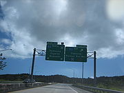
Exit list
Exits 2-39
- Exit 2: PR-3, Ceiba, Aeropuerto Diego Jimenez Torres
- Exit 5: PR-975, Ceiba Norte
- Exit 6: PR-978 (Carretera Chupacallos), Ceiba Sur
- Exit 10: PR-3
- Exit 13: PR-3/PR-973, Playa de Naguabo, Daguabo
- Exit 17: PR-971 (Camino El Duque), NaguaboNagüabo, Puerto RicoNaguabo is a municipality in Puerto Rico located in the east coast of the island, north of Humacao; south of Río Grande and Ceiba; and east of Las Piedras. Naguabo is spread over 8 wards and Naguabo Pueblo...
- Exit 18: PR-31Puerto Rico Highway 31Puerto Rico Highway 31 is a main, rural highway connecting Juncos, Puerto Rico at Puerto Rico Highway 198 to Naguabo, Puerto Rico at Puerto Rico Highway 3. It is a pass-by route for people who are going from Caguas and other towns west of Juncos to Naguabo without having to pass through Humacao,...
, NaguaboNagüabo, Puerto RicoNaguabo is a municipality in Puerto Rico located in the east coast of the island, north of Humacao; south of Río Grande and Ceiba; and east of Las Piedras. Naguabo is spread over 8 wards and Naguabo Pueblo... - Exit 20: PR-31Puerto Rico Highway 31Puerto Rico Highway 31 is a main, rural highway connecting Juncos, Puerto Rico at Puerto Rico Highway 198 to Naguabo, Puerto Rico at Puerto Rico Highway 3. It is a pass-by route for people who are going from Caguas and other towns west of Juncos to Naguabo without having to pass through Humacao,...
, JuncosJuncos, Puerto RicoJuncos is one of the 78 municipalities of Puerto Rico located in the eastern central region of the island, south of Canóvanas and Carolina; southeast of Gurabo; east of San Lorenzo; and west of Las Piedras. Juncos is spread over 9 wards and Juncos Pueblo...
, NaguaboNagüabo, Puerto RicoNaguabo is a municipality in Puerto Rico located in the east coast of the island, north of Humacao; south of Río Grande and Ceiba; and east of Las Piedras. Naguabo is spread over 8 wards and Naguabo Pueblo... - Exit 22: PR-31Puerto Rico Highway 31Puerto Rico Highway 31 is a main, rural highway connecting Juncos, Puerto Rico at Puerto Rico Highway 198 to Naguabo, Puerto Rico at Puerto Rico Highway 3. It is a pass-by route for people who are going from Caguas and other towns west of Juncos to Naguabo without having to pass through Humacao,...
, JuncosJuncos, Puerto RicoJuncos is one of the 78 municipalities of Puerto Rico located in the eastern central region of the island, south of Canóvanas and Carolina; southeast of Gurabo; east of San Lorenzo; and west of Las Piedras. Juncos is spread over 9 wards and Juncos Pueblo... - Exit 25: PR-927, Anton Ruiz
- Exit 31: PR-3Puerto Rico Highway 3Puerto Rico Highway 3 ' at nearly 101 miles long, is the second longest highway on Puerto Rico . It connects the San Juan neighborhood of Rio Piedras to downtown Salinas indirectly around the eastern coast of the island...
, HumacaoHumacao, Puerto RicoHumacao is a city in Puerto Rico located in the eastern coast of the island, north of Yabucoa; south of Naguabo; east of Las Piedras; and west of Vieques Passage. Humacao is spread over 10 wards and Humacao Pueblo... - Exit 33: PR-30Puerto Rico Highway 30Puerto Rico Highway 30, or PR-30 is a main freeway in Puerto Rico which connects the city of Caguas to the town of Humacao.-Exits:It is 30 kilometers long, and has several exits :CAGUAS...
, JuncosJuncos, Puerto RicoJuncos is one of the 78 municipalities of Puerto Rico located in the eastern central region of the island, south of Canóvanas and Carolina; southeast of Gurabo; east of San Lorenzo; and west of Las Piedras. Juncos is spread over 9 wards and Juncos Pueblo...
, CaguasCaguas, Puerto RicoCaguas , founded in 1775, is a city and municipality of Puerto Rico located in the Central Mountain Range of Puerto Rico, south of San Juan and Trujillo Alto, west of Gurabo and San Lorenzo, east of Aguas Buenas, Cidra, and Cayey....
, San JuanSan Juan, Puerto RicoSan Juan , officially Municipio de la Ciudad Capital San Juan Bautista , is the capital and most populous municipality in Puerto Rico, an unincorporated territory of the United States. As of the 2010 census, it had a population of 395,326 making it the 46th-largest city under the jurisdiction of... - Exit 35: PR-906, To PR-3, Candelero Abajo
- Exit 39: PR-906, Playa
Exits 83-90
- Exit 83: PR-7707
- Exit 87: PR-713, Jobos
- Exit 90: PR-706, To PR-3
- Exit: PR-52, PoncePonce, Puerto RicoPonce is both a city and a municipality in the southern part of Puerto Rico. The city is the seat of the municipal government.The city of Ponce, the fourth most populated in Puerto Rico, and the most populated outside of the San Juan metropolitan area, is named for Juan Ponce de León y Loayza, the...
, San JuanSan Juan, Puerto RicoSan Juan , officially Municipio de la Ciudad Capital San Juan Bautista , is the capital and most populous municipality in Puerto Rico, an unincorporated territory of the United States. As of the 2010 census, it had a population of 395,326 making it the 46th-largest city under the jurisdiction of...
External links
- Hawaii Highways: Puerto Rico – Puerto Rico Interstate Photographs (2002)