
Public transport in Dunedin
Encyclopedia
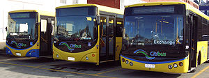
Public transport
in Dunedin
, New Zealand is mainly by bus
. Three bus companies operate routes under their respective brand
s, co-branded
with the Otago Regional Council
as "GoBus". There are 18 weekday routes and 12 weekend/public holiday routes.
Bus fares are paid for by cash, or by the electronic ticketing system "GoCard" which replaced paper multi-trip tickets in November 2007.
-accessible buses, and a further 2-3 non-wheelchair accessible buses mainly used at peak hours. Bus route service contracts are often split between weekday services and weeknight-weekend-holiday services. There are currently (in 2011) three local bus companies:
Most bus routes from the north and west are interconnected with routes from the south, with buses continuing from one route through to the other, forming one long bus route. For example, buses from Pine Hill continue though the Octagon to Lookout Point, and vice versa. Buses are signed through to their destination, so a bus from Pine Hill will be signed "40 Lookout Point", not "5 Octagon" and then "40 Lookout Point" (unless the bus terminates at the Octagon).
Key Route operated by Passenger Transport Citibus Route operated by Ritchies Route operated by Mosgiel Coach Services
Notes
 Taxi
Taxi
companies in Dunedin include the following:
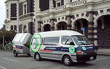
There are no conventional bus
services to Dunedin International Airport
: this airport is served by a large fleet of shuttle vans provided by several operators including most of the local taxi companies. Airport shuttle vans typically travel non-stop to or from the airport and meander about the city and suburbs picking up or dropping passengers at each address.
ed and subsidised
by the Otago Regional Council
and funded by ratepayer
s. Buses use the individual companies' livery
with Otago Regional Council GoBus sticker
s added. A couple of bus routes are operated commercially outside the Regional Council's control but still under the GoBus brand. All services are regulated by the New Zealand Transport Agency
(NZTA). The Dunedin City Council has no administrative role other than as provider of the road infrastructure (with the exception of State Highways, for which NZTA is the provider), street furniture such as signs and seats and regulation of parking at bus stop
s. However, the city council is involved in discussions with the regional council over taking over the management of public transport.
Fares are either paid in cash to the driver of the bus, or by GoCard. The GoCard is a radio frequency identification stored value card, similar to London's Oyster Card
and identical (except for branding) to the Metrocard used for public transport in Christchurch
. GoCards can be bought from the bus driver, or from Otago Regional Council or Dunedin City Council offices for $5, with a minimum top-up value of $10.
From 1 October 2010, GoBus fares are:
(similar to the famous San Francisco cable cars) operated between 1881 and 1957; electric trams operated on several routes from 1900 to 1956; and trolleybuses from 1950 to 1982.
New Zealand Government Railways Department operated Commuter trains from the Dunedin Railway Station
to Wingatui
and Mosgiel
, and to Port Chalmers
until 1982 and 1979, respectively. They also operated motor buses to the suburbs of Warrington, Cherry Farm, Brighton, Outram, Mosgiel.
In early times, there were ferries connecting the central city to Port Chalmers
and Portobello
, but these ceased in the 1930s when road connections along the harbour's edge were improved.
Former public transport operators companies in Dunedin include Turnbulls (Dunedin to Portobello); Newtons (Dunedin to Waverley), Otago Road Services (Dunedin to the suburbs of Green Island, Abbotsford and Fairfield) and Cesta Travel, later called Southeastern (a wide range of routes at various times).
The Taieri Gorge Railway
has expressed interest in running a reinstated commuter rail service in Dunedin, but has no plans to proceed with the idea without funding. The Otago Regional Council is opposed, maintaining that Dunedin's passenger transport requirements are being adequately served by the bus system.
Public transport
Public transport is a shared passenger transportation service which is available for use by the general public, as distinct from modes such as taxicab, car pooling or hired buses which are not shared by strangers without private arrangement.Public transport modes include buses, trolleybuses, trams...
in Dunedin
Dunedin
Dunedin is the second-largest city in the South Island of New Zealand, and the principal city of the Otago Region. It is considered to be one of the four main urban centres of New Zealand for historic, cultural, and geographic reasons. Dunedin was the largest city by territorial land area until...
, New Zealand is mainly by bus
Bus
A bus is a road vehicle designed to carry passengers. Buses can have a capacity as high as 300 passengers. The most common type of bus is the single-decker bus, with larger loads carried by double-decker buses and articulated buses, and smaller loads carried by midibuses and minibuses; coaches are...
. Three bus companies operate routes under their respective brand
Brand
The American Marketing Association defines a brand as a "Name, term, design, symbol, or any other feature that identifies one seller's good or service as distinct from those of other sellers."...
s, co-branded
Co-branding
Co-branding refers to several different marketing arrangements:Co-branding, also called brand partnership, is when two companies form an alliance to work together, creating marketing synergy...
with the Otago Regional Council
Otago Regional Council
Otago Regional Council is the regional council for the Otago region in the South Island of New Zealand. The council's principal office is Regional House on Stafford Street in Dunedin, with smaller offices in Queenstown and Alexandra....
as "GoBus". There are 18 weekday routes and 12 weekend/public holiday routes.
Bus fares are paid for by cash, or by the electronic ticketing system "GoCard" which replaced paper multi-trip tickets in November 2007.
Bus operators
The GoBus network is operated with over 55 low floor wheelchairWheelchair
A wheelchair is a chair with wheels, designed to be a replacement for walking. The device comes in variations where it is propelled by motors or by the seated occupant turning the rear wheels by hand. Often there are handles behind the seat for someone else to do the pushing...
-accessible buses, and a further 2-3 non-wheelchair accessible buses mainly used at peak hours. Bus route service contracts are often split between weekday services and weeknight-weekend-holiday services. There are currently (in 2011) three local bus companies:
- Passenger Transport-Citibus (also known under their pre-merger names: Dunedin Passenger Transport and Citibus) operates the great majority of weekday routes, and all evening/weekend/public holiday routes.
- Ritchies Transport operates weekday services to Pine Hill, Opoho, Lookout Point and Shiel Hill
- Mosgiel Coach Services operates one service to Kaikorai Valley and Concord
Routes
Weekdays
Weekday buses run Monday to Friday from 6:30am to between 6:00pm and 7:00pm (depending on route), when the evening services take over.Most bus routes from the north and west are interconnected with routes from the south, with buses continuing from one route through to the other, forming one long bus route. For example, buses from Pine Hill continue though the Octagon to Lookout Point, and vice versa. Buses are signed through to their destination, so a bus from Pine Hill will be signed "40 Lookout Point", not "5 Octagon" and then "40 Lookout Point" (unless the bus terminates at the Octagon).
| Route numbers | Outer terminus | | via | Central terminus | Interconnected route(s) | Notes | |
|---|---|---|---|---|---|---|
| 1/2 | Palmerston Palmerston, New Zealand The town of Palmerston, in New Zealand's South Island lies 50 kilometres to the north of the city of Dunedin. It is the largest town in the Waihemo Ward of the Waitaki District with a population of 890 residents... |
Waikouaiti Waikouaiti Waikouaiti is a small town in East Otago, New Zealand, within the city limits of Dunedin. The town is close to the coast and the mouth of the Waikouaiti River.... , Karitane Karitane The seaside settlement of Karitane is located within the limits of the city of Dunedin in New Zealand, 35 kilometres to the north of the city centre.... , Waitati Waitati Waitati is a small seaside settlement in Otago, New Zealand, within the city limits of Dunedin. It is located close to the tidal mudflats of Blueskin Bay, 19 kilometres north of the Dunedin city centre... |
Dunedin Cumberland Street |
- | Special fares apply | |
| 3/4 | Garden Village | Glenleith, Gardens, University University of Otago The University of Otago in Dunedin is New Zealand's oldest university with over 22,000 students enrolled during 2010.The university has New Zealand's highest average research quality and in New Zealand is second only to the University of Auckland in the number of A rated academic researchers it... , George Street George Street, Dunedin George Street is the main street of Dunedin, the second largest city in the South Island of New Zealand. It runs for two and a half kilometres north-northeast from The Octagon in the city centre to the foot of Pine Hill. It is straight and undulates gently as it skirts the edge of the hills to its... |
Octagon The Octagon, Dunedin The Octagon is the city centre of Dunedin, in the South Island of New Zealand.-Features:The Octagon is an eight sided plaza bisected by the city's main street, which is called George Street to the northeast and Princes Street to the southwest... |
23/24 Ocean Grove |  |
|
| 5/6 | Pine Hill | Gardens, George Street | Octagon | 39/40 Lookout Point | |
|
| 8/9 | Normanby North East Valley North East Valley is a suburb of the New Zealand city of Dunedin.-Geography and demographics:... |
Gardens, George Street | Octagon | 28/29 St Clair | ||
| 10/11 | Opoho Opoho Opoho is a suburb of the New Zealand city of Dunedin. It sits on the western flank of Signal Hill, New Zealand, to the northeast of the city centre, overlooking North East Valley and the Dunedin Botanic Gardens.... |
Gardens, George Street | Octagon | 21/22 Shiel Hill | |
|
| 13/14 | Port Chalmers Port Chalmers Port Chalmers is a suburb and the main port of the city of Dunedin, New Zealand, with a population of 3,000. Port Chalmers lies ten kilometres inside Otago Harbour, some 15 kilometres northeast from Dunedin's city centre.... Harrington Street |
Port Chalmers Central, Sawyers Bay Sawyers Bay Sawyers Bay is a suburb of the New Zealand city of Dunedin. It is located to the southwest of Port Chalmers in a wide valley on the shore of Mussel Bay, to the northeast of Dunedin city centre.... , Roseneath Roseneath, Otago Roseneath is a small suburb of the New Zealand city of Dunedin, located on the northwestern shore of Otago Harbour, to the northeast of Dunedin city centre. It is situated between Saint Leonards and Port Chalmers on a rocky promontory of the same name which juts into the harbour between Sawyers... , St Leonards, Burkes, Ravensbourne Ravensbourne, New Zealand Ravensbourne is a suburb of the New Zealand city of Dunedin. It is located on the steep southeastern slopes of Signal Hill above the Otago Harbour. It lies on the harbour's northern shore, east-northeast of the city centre... , Fertilizer Works, Logan Park Logan Park, Dunedin Logan Park is a sporting venue in the city of Dunedin, New Zealand. It lies on land reclaimed from the former Lake Logan.- History :Lake Logan was reclaimed in the early 20th century... , University (inbound), George Street (inbound), Octagon (inbound) |
Countdown Cumberland Street |
- | ||
| 17/18 | Portobello Portobello, New Zealand Portobello is a village beside the Otago Harbour halfway along the Otago Peninsula in Dunedin City, New Zealand. It lies at the foot of a small peninsula between Portobello Bay and Latham Bay.... |
Edwards Bay, Turnbulls Bay, Broad Bay Broad Bay, New Zealand The settlement of Broad Bay is located on the Otago Harbour coast of Otago Peninsula, in the South Island of New Zealand. It is administered as part of the city of Dunedin, and is technically a suburb of that city, though its isolation and semi-rural nature make it appear as a settlement in its own... , Company Bay, Macandrew Bay, The Cove Challis, New Zealand "The Cove, New Zealand" redirects here. For other things called "The Cove", see Cove Challis is a settlement on the Otago Harbour coast of Otago Peninsula, within the city limits of the New Zealand city of Dunedin... , Exchange |
Centre City New World | - | |
|
| 19/20 | Highcliff | Waverley Waverley, Otago Waverley is a suburb of the New Zealand city of Dunedin. It is located at the start of the Otago Peninsula, southeast of the city centre, on a rise overlooking the Otago Harbour to the north.... , Musselburgh Musselburgh, New Zealand Musselburgh is a residential suburb of the New Zealand city of Dunedin. It is located in the southeast of the city's urban area, southeast of the city's centre, and at the narrowest point of the isthmus which joins Otago Peninsula to the rest of the South Island . The suburb takes its name from... (outbound), Exchange |
Centre City New World | - | |
|
| 21/22 | Shiel Hill Shiel Hill Shiel Hill is a residential suburb of the New Zealand city of Dunedin. It is located at the southeastern edge of the city's urban area, southeast of the city's centre at the western end of the Otago Peninsula, close to the isthmus joining the peninsula to the mainland... |
Musselburgh, Exchange | Octagon | 10/11 Opoho | |
|
| 23/24 | Ocean Grove Ocean Grove, New Zealand Ocean Grove, also known as Tomahawk, is a suburb in the southeast of the New Zealand city of Dunedin. A semi-rural residential suburb on the Pacific coast at the southwestern end of the Otago Peninsula, Ocean Grove is located southeast of Dunedin city centre.The suburb is isolated from much of the... |
Bay Cemetery, Cargills Corner, Exchange | Octagon | 3/4 Garden Village | |
|
| 25/26 | St Kilda Saint Kilda, New Zealand St Kilda is a suburb of the New Zealand city of Dunedin. A densely populated residential suburb, it lies on the southern part of the city's central plain, to the southwest of the head of the harbour and immediately north of Ocean Beach, parts of which are within the suburb and form its major... |
Cargills Corner, Exchange | Octagon | 53/55 Brockville 57/58 Halfway Bush |
||
| 28/29 | St Clair Saint Clair, New Zealand St Clair is a leafy residential suburb of the New Zealand city of Dunedin. It is located on the Pacific Ocean coast five kilometres from the city centre on the southwesternmost part of the coastal plain which makes up the southern part of the urban area, and also climbs the slopes of Forbury Hill... |
Cargills Corner, Exchange | Octagon | 8/9 Normanby | ||
| 32/34 | Corstorphine Corstorphine, New Zealand Corstorphine is a suburb of southwest Dunedin in the South Island of New Zealand. It is located on the slopes of Calton Hill - a spur of Forbury Hill - between Caversham Valley and the Pacific Ocean... |
Kew, Cargills Corner, Exchange | Octagon | 50/51 Wakari Hospital | |
|
| 33/35 | Corstorphine | Caversham Caversham, New Zealand Caversham is one of the older suburbs of the South Island New Zealand city of Dunedin. It is sited at the western edge of the city's central plain at the mouth of the steep Caversham Valley, which rises to the saddle of Lookout Point... , Exchange |
Octagon | 50/51 Wakari Hospital | |
|
| 37/38 | Concord | Kenmure, Bradford, Kaikorai, Moana Pool Moana Pool Moana Pool is the largest swimming pool in the southern half of New Zealand's South Island. It is located at the corner of Littlebourne Road and Upper Stuart Street close to Otago Boys' High School, on the slopes of Roslyn, overlooking the centre of the city of Dunedin.The largest of Dunedin's four... , Octagon (outbound), George Street (outbound) |
University | - | |
|
| 39/40 | Lookout Point / Calton Hill | Caversham, Exchange | Octagon | 5/6 Pine Hill | |
|
| 50/51 | Wakari Hospital Wakari Hospital Wakari Hospital is a psychiatric hospital located in Dunedin, New Zealand.It is situated in the suburb of Wakari, about three kilometres north-west of the city centre... |
Helensburgh, Wakari Wakari Wakari is a residential suburb of the New Zealand city of Dunedin. It is located to the northwest of the city centre, immediately to the west of the ridge which runs to the west of the city's centre. Wakari lies to the north of the upper reaches of the Kaikorai Valley, and is also north of the... , Kaikorai, Moana Pool, George Street (inbound) |
Octagon | 32/34 Corstorphine via Kew 33/35 Corstorphine via Caversham |
|
|
| 53/55 | Brockville Brockville, New Zealand Brockville is a residential suburb of the New Zealand city of Dunedin. It is located at the edge of the city's main urban area, to the northwest of the city centre, but separated from it by both a ridge of hills and the Kaikorai Valley.... |
Halfway Bush Halfway Bush Halfway Bush is a suburb of the New Zealand city of Dunedin. It is located to the northwest of the city centre, close to the point at which Taieri Road becomes the winding rural Three Mile Hill Road... , Kaikorai, Moana Pool, George Street (inbound) |
Octagon | 25/26 St Kilda | ||
| 57/58 | Halfway Bush | Brockville, Bradford, Kaikorai, Moana Pool, George Street (inbound) | Octagon | 25/26 St Kilda | ||
| 59/60 | Bradford | Belleknowles, Belgrave Crescent, City Rise City Rise City Rise is an inner suburb of the New Zealand city of Dunedin. One of the city's older suburbs, it is, as its name suggests, centred on the slopes which lie close to the city centre, particularly those closest to the city's original heart of The Exchange... , Octagon, George Street |
University | - | |
|
| 61/62 | Kenmure | Mornington Mornington, Otago Mornington is a suburb of the city of Dunedin, in the South Island of New Zealand. It is situated on hilly slopes to the west of the city centre, the slopes forming part of a ridge which surrounds the heart of the city.... , Octagon, George Street |
University | - | |
|
| 63/64 | Balaclava | Mornington, Octagon, George Street | University | - | |
|
| 66/67 | Belgrave Crescent | Roslyn Roslyn, Otago Roslyn is a major residential and retail suburb of the New Zealand city of Dunedin. It is located above the city centre on the ridge which runs in a crescent around the central city's western edge. It is to the northwest of the city centre, immediately above the Town Belt. Roslyn's 2001... , Maori Hill Maori Hill Maori Hill is a residential suburb of the New Zealand city of Dunedin. It is located at the northern end of the ridge which runs in a crescent around the central city's western edge, to the northwest of the city centre, immediately above and within the Town Belt... , Prospect Park, University, George Street |
Octagon | - | |
|
| 70/71 | Brighton Brighton, New Zealand "Ocean View, New Zealand" redirects here. For the inner Dunedin suburb occasionally referred to as Ocean View, see Andersons BayBrighton is a small seaside town within the city limits of Dunedin, in New Zealand's South Island. It is located 20 kilometres southwest from the city centre on the... |
Ocean View, Waldronville Waldronville Waldronville is a coastal settlement on the Pacific Ocean coast of the South Island of New Zealand. Established in the 1950s as a commuter settlement, it is located to the southwest of Dunedin city centre, and lies within the city's limits. Waldronville was developed by Bill Waldron, when he... , Green Island Green Island, New Zealand Green Island is an island off the coast of Dunedin, New Zealand, also the name of one of the city's suburbs. The suburb is not on the sea — formerly a borough, it took its name from the Green Island bush, uncleared native forest extending from the valley where the town is centred over the hills... , Burnside Burnside, Otago Burnside is a mainly industrial suburb of the New Zealand city of Dunedin. It is located at the mouth of a long valley, the Kaikorai Valley, through which flows the Kaikorai Stream. This valley stretches to the northeast for . Burnside is to the southwest of the city centre, close to eastern end... , Caversham, Cargills Corner (inbound), Exchange, Octagon |
Centre City New World | - | |
|
| 72/73 | Abbotsford McKinlay Road |
Abbotsford Central, Green Island, Burnside, Caversham, Cargills Corner (inbound), Exchange, Octagon | Centre City New World | - | |
|
| 74/75 | Green Island | Burnside, Caversham, Cargills Corner (inbound), Exchange, Octagon | Centre City New World | - | |
|
| 76/77 | Mosgiel Mosgiel Mosgiel is an urban satellite of Dunedin in Otago, New Zealand, fifteen kilometres west of the city's centre. Since the re-organisation of New Zealand local government in 1989 it has been inside the Dunedin City Council area, but was physically separate from the contiguous suburbs until... Centre Street |
Mosgiel Gordon Road, Fairfield Fairfield, Otago The quiet suburb of Fairfield lies 10 kilometres to the west of Dunedin CBD, in Otago, southern New Zealand.Fairfield lies in rolling hill country between Abbotsford and the Taieri Plains, close to the slopes of Saddle Hill and Scroggs Hill... , Sunnyvale, Green Island, Burnside, Caversham, Cargills Corner (inbound), Exchange, Octagon |
Centre City New World | - | |
|
| | 78/79 | Mosgiel Centre Street |
Mosgiel Centre Road, Dunedin Southern Motorway Dunedin Southern Motorway The Dunedin Southern Motorway is the main arterial route south from the South Island city of Dunedin, part of New Zealand's State Highway 1. It is one of the world's southernmost motorways.-Route:... , Exchange, Octagon |
Centre City New World | - | Mosgiel Express |
|
| 80/81 | Mosgiel Gordon Road |
Mosgiel East, Gordon Road, Mosgiel West | Mosgiel Gordon Road |
- | Mosgiel Loop |
Key Route operated by Passenger Transport Citibus Route operated by Ritchies Route operated by Mosgiel Coach Services
- All buses on route are wheelchair-accessible
- Buses on route fitted with bike racks
Notes
Evenings, Weekends and Public Holidays
All services are operated by Passenger Transport Citibus| Route numbers | From/returning to | | via | Notes |
|---|---|---|---|
| 7 | Octagon | George Street, Gardens, Pine Hill, Opoho | |
| 8/9 | Octagon | George Street, Gardens, Normanby | interconnects with 28/29 St Clair |
| 13/14 | Countdown Cumberland Street | Logan Park, Fertilizer Works, Ravensbourne, Burkes, St Leonards, Roseneath, Sawyers Bay, Port Chalmers, Harrington Street | |
| 17/18 | Centre City New World | Exchange, The Cove, Macandrew Bay, Company Bay, Broad Bay, Turnbulls Bay, Edwards Bay, Portobello | |
| 27 | Octagon | Exchange, Cargills Corner, St Kilda, Musselburgh, Shiel Hill | not Saturday daytimes |
| 27B | Octagon | Exchange, Cargills Corner, St Kilda | Saturday daytime |
| 27C | Octagon | Exchange, Cargills Corner (return only), Musselburgh, Shiel Hill | Saturday daytime |
| 28/29 | Octagon | Exchange, Cargills Corner, St Clair | interconnects with 8/9 Normanby |
| 36 | Octagon | Exchange, Cargills Corner, Kew, Corstorphine, Lookout Point, Carton Hill, Caversham | |
| 56 | Octagon | George Street (return only), Moana Pool, Kaikorai, Brockville, Halfway Bush, Wakari Hospital | |
| 65 | Octagon | Mornington, Balaclava, Kenmure | continues to University Saturday daytime |
| 68 | Octagon | City Rise, Roslyn, Maori Hill, University, George Street | |
| 69 | Octagon | Moana Pool, Kaikorai, Wakari, Helensburgh, Maori Hill, Gardens, University, George Street | |
| 70/71 | Centre City New World | Octagon, Exchange, Cargills Corner (return only), Caversham, Burnside, Green Island, Waldronville, Ocean View, Brighton | |
| 72/73 | Centre City New World | Octagon, Exchange, Cargills Corner (return only), Caversham, Burnside, Green Island, Abbotsford, McKinlay Road | not Sundays or Public holidays |
| 74/75 | Centre City New World | Octagon, Exchange, Cargills Corner (return only), Caversham, Burnside, Green Island | |
| 76/77 | Centre City New World | Octagon, Exchange, Cargills Corner (return only), Caversham, Burnside, Green Island, Sunnyvale, Fairfield, Mosgiel, Centre Street |
Other transport services
Taxicab
A taxicab, also taxi or cab, is a type of vehicle for hire with a driver, used by a single passenger or small group of passengers, often for a non-shared ride. A taxicab conveys passengers between locations of their choice...
companies in Dunedin include the following:
- City Taxis
- Dunedin Taxis
- United Taxis Dunedin
There are no conventional bus
Bus
A bus is a road vehicle designed to carry passengers. Buses can have a capacity as high as 300 passengers. The most common type of bus is the single-decker bus, with larger loads carried by double-decker buses and articulated buses, and smaller loads carried by midibuses and minibuses; coaches are...
services to Dunedin International Airport
Dunedin International Airport
Dunedin International Airport is an international airport in the Otago region of the South Island of New Zealand, serving Dunedin city and the Otago and Southland regions. Dunedin International Airport is one of two international airports in Otago, the other being Queenstown International Airport...
: this airport is served by a large fleet of shuttle vans provided by several operators including most of the local taxi companies. Airport shuttle vans typically travel non-stop to or from the airport and meander about the city and suburbs picking up or dropping passengers at each address.
Organising public transport in Dunedin
The vast majority of Dunedin's bus network is designed, specified, contractContract
A contract is an agreement entered into by two parties or more with the intention of creating a legal obligation, which may have elements in writing. Contracts can be made orally. The remedy for breach of contract can be "damages" or compensation of money. In equity, the remedy can be specific...
ed and subsidised
Subsidy
A subsidy is an assistance paid to a business or economic sector. Most subsidies are made by the government to producers or distributors in an industry to prevent the decline of that industry or an increase in the prices of its products or simply to encourage it to hire more labor A subsidy (also...
by the Otago Regional Council
Otago Regional Council
Otago Regional Council is the regional council for the Otago region in the South Island of New Zealand. The council's principal office is Regional House on Stafford Street in Dunedin, with smaller offices in Queenstown and Alexandra....
and funded by ratepayer
Rates (tax)
Rates are a type of property tax system in the United Kingdom, and in places with systems deriving from the British one, the proceeds of which are used to fund local government...
s. Buses use the individual companies' livery
Livery
A livery is a uniform, insignia or symbol adorning, in a non-military context, a person, an object or a vehicle that denotes a relationship between the wearer of the livery and an individual or corporate body. Often, elements of the heraldry relating to the individual or corporate body feature in...
with Otago Regional Council GoBus sticker
Sticker
A sticker is a type of a piece of paper or plastic, adhesive, sticky on one side, and usually with a design on the other. They can be used for decoration, depending on the situation. They can come in many different shapes, sizes and colours and are put on things such as lunchboxes, in children's...
s added. A couple of bus routes are operated commercially outside the Regional Council's control but still under the GoBus brand. All services are regulated by the New Zealand Transport Agency
New Zealand Transport Agency
The New Zealand Transport Agency is a New Zealand Crown entity tasked with promoting safe and functional transport by land, including the responsibility for driver and vehicle licensing and investigating rail accidents. It was created on 1 August 2008 by the Land Transport Management Amendment...
(NZTA). The Dunedin City Council has no administrative role other than as provider of the road infrastructure (with the exception of State Highways, for which NZTA is the provider), street furniture such as signs and seats and regulation of parking at bus stop
Bus stop
A bus stop is a designated place where buses stop for passengers to board or leave a bus. These are normally positioned on the highway and are distinct from off-highway facilities such as bus stations. The construction of bus stops tends to reflect the level of usage...
s. However, the city council is involved in discussions with the regional council over taking over the management of public transport.
Fares
All GoBus services except the Palmerston service operate on a zone-based fare scheme. There are seven concentric fare zones, with Zone 1 containing central Dunedin, and Zone 7 containing Mosgiel, Brighton, and Harington Point. The Palmerston service operates independently of the zone system.Fares are either paid in cash to the driver of the bus, or by GoCard. The GoCard is a radio frequency identification stored value card, similar to London's Oyster Card
Oyster card
The Oyster card is a form of electronic ticketing used on public transport services within the Greater London area of the United Kingdom. It is promoted by Transport for London and is valid on a number of different travel systems across London including London Underground, buses, the Docklands...
and identical (except for branding) to the Metrocard used for public transport in Christchurch
Public transport in Christchurch
Public transport in Christchurch, New Zealand consists of bus services operated by three bus companies supported by a ferry, all jointly marketed as Metro.-Overview:...
. GoCards can be bought from the bus driver, or from Otago Regional Council or Dunedin City Council offices for $5, with a minimum top-up value of $10.
From 1 October 2010, GoBus fares are:
| Zones | | Cash | | GoCard | |||
|---|---|---|---|---|---|
| Adult | Child | Adult | Concession | Child | |
| One | $1.90 | $1.30 | $1.75 | $1.46 | $1.20 |
| Two | $2.60 | $1.60 | $2.30 | $1.92 | $1.47 |
| Three | $3.20 | $1.90 | $2.85 | $2.38 | $1.75 |
| Four | $3.70 | $2.40 | $3.31 | $2.76 | $2.12 |
| Five | $4.50 | $2.60 | $4.05 | $3.37 | $2.30 |
| Six | $5.50 | $3.20 | $4.97 | $4.14 | $2.85 |
| Seven | $6.40 | $3.90 | $5.80 | $4.83 | $3.50 |
History of public transport in Dunedin
The Dunedin City Council operated other forms of public transport — the Dunedin cable tramway systemDunedin cable tramway system
The Dunedin cable tramway system was a group of cable tramway lines in the New Zealand city of Dunedin. It is significant as Dunedin was the second city in the world to adopt the cable car .- History :...
(similar to the famous San Francisco cable cars) operated between 1881 and 1957; electric trams operated on several routes from 1900 to 1956; and trolleybuses from 1950 to 1982.
New Zealand Government Railways Department operated Commuter trains from the Dunedin Railway Station
Dunedin Railway Station
Possibly the best-known building in the southern half of New Zealand's South Island, Dunedin Railway Station is a jewel in the country's architectural crown. Designed by George Troup, the station is the fourth building to have served as Dunedin's railway station...
to Wingatui
Wingatui
Wingatui is a small settlement almost 15 kilometres west of Dunedin, and two kilometres east of Mosgiel. It has become a suburb of Mosgiel, but continues to maintain its own unique identity and heritage....
and Mosgiel
Mosgiel
Mosgiel is an urban satellite of Dunedin in Otago, New Zealand, fifteen kilometres west of the city's centre. Since the re-organisation of New Zealand local government in 1989 it has been inside the Dunedin City Council area, but was physically separate from the contiguous suburbs until...
, and to Port Chalmers
Port Chalmers
Port Chalmers is a suburb and the main port of the city of Dunedin, New Zealand, with a population of 3,000. Port Chalmers lies ten kilometres inside Otago Harbour, some 15 kilometres northeast from Dunedin's city centre....
until 1982 and 1979, respectively. They also operated motor buses to the suburbs of Warrington, Cherry Farm, Brighton, Outram, Mosgiel.
In early times, there were ferries connecting the central city to Port Chalmers
Port Chalmers
Port Chalmers is a suburb and the main port of the city of Dunedin, New Zealand, with a population of 3,000. Port Chalmers lies ten kilometres inside Otago Harbour, some 15 kilometres northeast from Dunedin's city centre....
and Portobello
Portobello, New Zealand
Portobello is a village beside the Otago Harbour halfway along the Otago Peninsula in Dunedin City, New Zealand. It lies at the foot of a small peninsula between Portobello Bay and Latham Bay....
, but these ceased in the 1930s when road connections along the harbour's edge were improved.
Former public transport operators companies in Dunedin include Turnbulls (Dunedin to Portobello); Newtons (Dunedin to Waverley), Otago Road Services (Dunedin to the suburbs of Green Island, Abbotsford and Fairfield) and Cesta Travel, later called Southeastern (a wide range of routes at various times).
The Taieri Gorge Railway
Taieri Gorge Railway
The Taieri Gorge Railway is a railway line and tourist train operation based at Dunedin Railway Station in the South Island of New Zealand...
has expressed interest in running a reinstated commuter rail service in Dunedin, but has no plans to proceed with the idea without funding. The Otago Regional Council is opposed, maintaining that Dunedin's passenger transport requirements are being adequately served by the bus system.