

Roslyn, Otago
Encyclopedia
New Zealand
New Zealand is an island country in the south-western Pacific Ocean comprising two main landmasses and numerous smaller islands. The country is situated some east of Australia across the Tasman Sea, and roughly south of the Pacific island nations of New Caledonia, Fiji, and Tonga...
city of Dunedin
Dunedin
Dunedin is the second-largest city in the South Island of New Zealand, and the principal city of the Otago Region. It is considered to be one of the four main urban centres of New Zealand for historic, cultural, and geographic reasons. Dunedin was the largest city by territorial land area until...
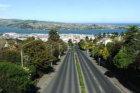
. It is located 150 metres (492.1 ft) above the city centre on the ridge which runs in a crescent around the central city's western edge. It is 2.5 kilometres (1.6 mi) to the northwest of the city centre, immediately above the Town Belt
Town Belt
The Town Belt is a green belt which surrounds the centre of the New Zealand city of Dunedin. Covering a total of over , it extends around three sides of the city's centre at a distance from it of some 1-3 km in a broad crescent from the Oval at Kensington in the south through the suburbs of...
. Roslyn's 2001 population was 3,957.
Roslyn is connected to the city's CBD
Central business district
A central business district is the commercial and often geographic heart of a city. In North America this part of a city is commonly referred to as "downtown" or "city center"...
via Stuart Street
Stuart Street, Dunedin
Stuart Street is one of the main streets of Dunedin, New Zealand. As with many of Dunedin's streets, it is named after a main street in Edinburgh, Scotland....
and City Road. The former of these runs below Roslyn under the Roslyn Overbridge
Roslyn Overbridge
The Roslyn Overbridge is a landmark in the New Zealand city of Dunedin. Located northwest of the city's centre , it allows for the passage of the arterial Upper Stuart Street under Highgate, the main suburban road which runs along the ridge of hills which surrounds the city centre.The bridge,...
, and is linked to the suburb via a complex interchange To the west of Roslyn, Stuart Street passes the suburbs of Kaikorai and Wakari
Wakari
Wakari is a residential suburb of the New Zealand city of Dunedin. It is located to the northwest of the city centre, immediately to the west of the ridge which runs to the west of the city's centre. Wakari lies to the north of the upper reaches of the Kaikorai Valley, and is also north of the...
before becoming Taieri Road, which eventually traverses Three Mile Hill to reach the Taieri Plains
Taieri Plains
The Taieri Plains are an area of fertile agricultural land to the southwest of Dunedin, in Otago, New Zealand. The plains cover an area of some 300 square kilometres, with a maximum extent of 30 kilometres....
. City Road travels through Belleknowes before linking with Rattray Street and descending the City Rise
City Rise
City Rise is an inner suburb of the New Zealand city of Dunedin. One of the city's older suburbs, it is, as its name suggests, centred on the slopes which lie close to the city centre, particularly those closest to the city's original heart of The Exchange...
, reaching the central city at The Exchange
Princes Street, Dunedin
Princes Street is a major street in Dunedin, the second largest city in the South Island of New Zealand. It runs south-southwest for two kilometres from The Octagon in the city centre to the Oval sports ground, close to the city's Southern Cemetery...
. Roslyn is also connected to the suburbs of Mornington
Mornington, Otago
Mornington is a suburb of the city of Dunedin, in the South Island of New Zealand. It is situated on hilly slopes to the west of the city centre, the slopes forming part of a ridge which surrounds the heart of the city....
to the southwest and Maori Hill
Maori Hill
Maori Hill is a residential suburb of the New Zealand city of Dunedin. It is located at the northern end of the ridge which runs in a crescent around the central city's western edge, to the northwest of the city centre, immediately above and within the Town Belt...
to the northeast by way of Highgate, Roslyn's main road.
Roslyn is predominantly residential, though it does contain one of the city's peripheral retail areas at and around Roslyn Village on Highgate just to the southwest of the overbridge. One of the city's most notable single-sex girls' schools, Columba College
Columba College
Columba College is an integrated presbyterian school in Roslyn, Dunedin, New Zealand. The roll is made up of pupils of all ages...
, is located close to the suburb's border with Maori Hill.
The suburb and its neighbour, Wakari, between them lend their names to one of Dunedin's most prominent soccer teams, Roslyn-Wakari
Roslyn-Wakari
Roslyn-Wakari A.F.C. is an amateur association football club in Dunedin, New Zealand. They compete in the ODT Footballsouth Premier League.-History:...
. This team's home ground is actually at Ellis Park in Kaikorai, immediately to the northwest of Roslyn. Also in Kaikorai is the building of the former Roslyn Woollen Mills, a company through whose products the name of Roslyn was widely known nationwide.
History
Roslyn was named after RoslinRoslin, Midlothian
Roslin is a pretty village in Midlothian, Scotland, 7 miles to the south of the Scottish Capital city Edinburgh. It is situated approximately 12 miles from Edinburgh Airport.-The name:...
in Scotland. Many street names and some district names in Dunedin derive from like features in Edinburgh
Edinburgh
Edinburgh is the capital city of Scotland, the second largest city in Scotland, and the eighth most populous in the United Kingdom. The City of Edinburgh Council governs one of Scotland's 32 local government council areas. The council area includes urban Edinburgh and a rural area...
and its surrounds.
Littlebourne
The locality of Littlebourne, considered by some a separate suburb, lies in the Town BeltTown Belt
The Town Belt is a green belt which surrounds the centre of the New Zealand city of Dunedin. Covering a total of over , it extends around three sides of the city's centre at a distance from it of some 1-3 km in a broad crescent from the Oval at Kensington in the south through the suburbs of...
on the slopes immediately below and to the southeast of Roslyn. Notable features of Littlebourne include Otago Boys' High School
Otago Boys' High School
Otago Boys' High School is one of New Zealand's oldest boys' secondary schools, located in Dunedin, Otago, New Zealand. It was founded on 3 August 1863 and moved to its present site in 1885. The main building was designed by Robert Lawson and is regarded as one of the finest Gothic revival...
and its sportsground, the Littlebourne Ground, and the city's main swimming pool, Moana Pool
Moana Pool
Moana Pool is the largest swimming pool in the southern half of New Zealand's South Island. It is located at the corner of Littlebourne Road and Upper Stuart Street close to Otago Boys' High School, on the slopes of Roslyn, overlooking the centre of the city of Dunedin.The largest of Dunedin's four...
.
Cable cars
Roslyn was in earlier times served by two separate cable carCable car (railway)
A cable car or cable railway is a mass transit system using rail cars that are hauled by a continuously moving cable running at a constant speed. Individual cars stop and start by releasing and gripping this cable as required...
lines (see Dunedin cable tramway system
Dunedin cable tramway system
The Dunedin cable tramway system was a group of cable tramway lines in the New Zealand city of Dunedin. It is significant as Dunedin was the second city in the world to adopt the cable car .- History :...
).
One came up Stuart Street
Stuart Street, Dunedin
Stuart Street is one of the main streets of Dunedin, New Zealand. As with many of Dunedin's streets, it is named after a main street in Edinburgh, Scotland....
from The Octagon
The Octagon, Dunedin
The Octagon is the city centre of Dunedin, in the South Island of New Zealand.-Features:The Octagon is an eight sided plaza bisected by the city's main street, which is called George Street to the northeast and Princes Street to the southwest...
, turned half right at York Place into what was then called Albert Street, continued on past the end of that street through a short section of the Town Belt
Town Belt
The Town Belt is a green belt which surrounds the centre of the New Zealand city of Dunedin. Covering a total of over , it extends around three sides of the city's centre at a distance from it of some 1-3 km in a broad crescent from the Oval at Kensington in the south through the suburbs of...
, past Otago Boys' High School
Otago Boys' High School
Otago Boys' High School is one of New Zealand's oldest boys' secondary schools, located in Dunedin, Otago, New Zealand. It was founded on 3 August 1863 and moved to its present site in 1885. The main building was designed by Robert Lawson and is regarded as one of the finest Gothic revival...
, across the bottom of Littlebourne Crescent, and up to Highgate at School Street, then dropped down to Kaikorai just before Nairn Street, where a turntable in the road turned cars through ninety degrees and sent them south-west into their shed if it was time to go there. The route was eventually turned into a four-lane highway, cutting Littlebourne Crescent off from Littlebourne Road, going under the new bridge and undergoing considerable widening on the Kaikorai side, restricting access to Ann Street and Oates Street.
The other line went up Rattray Street then cut through the Town Belt (where the cutting is still generally visible) past the Beverly-Begg Observatory
Beverly-Begg Observatory
The Beverly-Begg Observatory a New Zealand astronomical observatory, situated on Robin Hood Park in the Belleknowes part of Dunedin's town belt. It was established in 1922 by the Dunedin Astronomical Society and is the home of the group...
to climb the full length of Ross Street and part of Belgrave Crescent, then descend through a cutting to the valley near Frasers Road. The western section beyond the cutting was too steep for a road link, so, when the cable cars ceased, the portion near Belgrave Crescent was redeveloped as a short street serving several houses while retaining the pedestrian walkway through to Delta Street. Trolleybuses replaced the service as far as Belgrave Crescent, using the existing City Road instead of the straight steep cutting through the Town Belt.