
Prairie Bluff, Alabama
Encyclopedia
Prairie Bluff, also known as Daletown and Prairie Blue, is a ghost town
in Wilcox County
, Alabama
.
The town was located at the midpoint of an early road that connected Cahaba
, the first state
capital, and St. Stephens
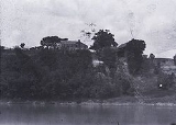
, the territorial capital. Situated atop a cliff overlooking the Alabama River
, the town grew as river trade increased. A large cotton
slide, used to move bales of cotton from the top of the cliff to paddle steamer
s on the river below, was located at the site. The steamboat Pittsburg sank near Prairie Bluff in May 1828, followed by the Jewess on October 28, 1841.
The town was at its height in 1861, but declined rapidly in importance with the introduction of new railroads following the American Civil War
. Portions of the site were inundated by the William "Bill" Dannelly Reservoir
with the construction of the nearby Millers Ferry Lock and Dam
in 1963. The only physical feature that remains at the site today is the Prairie Bluff Cemetery, with marked graves dating from the 1830s to the 1860s.
, a geological formation that was named after the town.
Ghost town
A ghost town is an abandoned town or city. A town often becomes a ghost town because the economic activity that supported it has failed, or due to natural or human-caused disasters such as floods, government actions, uncontrolled lawlessness, war, or nuclear disasters...
in Wilcox County
Wilcox County, Alabama
Wilcox County is a county of the U.S. state of Alabama. Its name is in honor of Lieutenant J. M. Wilcox, who fought in the wars against the Creek tribe. As of 2010, the population was 11,670...
, Alabama
Alabama
Alabama is a state located in the southeastern region of the United States. It is bordered by Tennessee to the north, Georgia to the east, Florida and the Gulf of Mexico to the south, and Mississippi to the west. Alabama ranks 30th in total land area and ranks second in the size of its inland...
.
History
Prairie Bluff first appeared on maps in 1819, the same year that Alabama was admitted to the Union as a state. It was listed erroneously as Prairie Blue on Fielding Lucas' Geographic, statistical, and historical map of Alabama, printed in Philadelphia in 1822. However, another of Lucas' Alabama maps, also printed in 1822, lists it as Prairie Bluff. It is interchangeably listed as Dale, Daletown, or Prairie Bluff on subsequent maps from the 1830s until the mid-1850s, after which time Prairie Bluff is the only name used. It disappeared from maps altogether around 1900.The town was located at the midpoint of an early road that connected Cahaba
Cahaba, Alabama
Cahaba, also spelled Cahawba, was the first permanent state capital of Alabama from 1820 to 1825. It is now a ghost town and state historic site. The site is located in Dallas County, southwest of Selma.-Capital:...
, the first state
U.S. state
A U.S. state is any one of the 50 federated states of the United States of America that share sovereignty with the federal government. Because of this shared sovereignty, an American is a citizen both of the federal entity and of his or her state of domicile. Four states use the official title of...
capital, and St. Stephens
St. Stephens, Alabama
St. Stephens is an unincorporated census-designated place in Washington County, Alabama, United States. As of the 2010 census, its population was 495. Located near the Tombigbee River in the southwestern part of the state, it is composed of two distinct sites: Old St. Stephens and New St. Stephens....
, the territorial capital. Situated atop a cliff overlooking the Alabama River
Alabama River
The Alabama River, in the U.S. state of Alabama, is formed by the Tallapoosa and Coosa rivers, which unite about north of Montgomery.The river flows west to Selma, then southwest until, about from Mobile, it unites with the Tombigbee, forming the Mobile and Tensaw rivers, which discharge into...
, the town grew as river trade increased. A large cotton
Cotton
Cotton is a soft, fluffy staple fiber that grows in a boll, or protective capsule, around the seeds of cotton plants of the genus Gossypium. The fiber is almost pure cellulose. The botanical purpose of cotton fiber is to aid in seed dispersal....
slide, used to move bales of cotton from the top of the cliff to paddle steamer
Paddle steamer
A paddle steamer is a steamship or riverboat, powered by a steam engine, using paddle wheels to propel it through the water. In antiquity, Paddle wheelers followed the development of poles, oars and sails, where the first uses were wheelers driven by animals or humans...
s on the river below, was located at the site. The steamboat Pittsburg sank near Prairie Bluff in May 1828, followed by the Jewess on October 28, 1841.
The town was at its height in 1861, but declined rapidly in importance with the introduction of new railroads following the American Civil War
American Civil War
The American Civil War was a civil war fought in the United States of America. In response to the election of Abraham Lincoln as President of the United States, 11 southern slave states declared their secession from the United States and formed the Confederate States of America ; the other 25...
. Portions of the site were inundated by the William "Bill" Dannelly Reservoir
William "Bill" Dannelly Reservoir
The William "Bill" Dannelly Reservoir is a reservoir created by Millers Ferry Lock and Dam on the Alabama River in Dallas County and Wilcox County in Alabama. It covers and has approximately of shoreline...
with the construction of the nearby Millers Ferry Lock and Dam
Millers Ferry Lock and Dam
Millers Ferry Lock and Dam is a lock and hydroelectric dam on the Alabama River, near the community of Millers Ferry, Alabama. It was built by and continues to be operated by the United States Army Corps of Engineers. Construction of the complex began in 1963 and was completed in 1974. The...
in 1963. The only physical feature that remains at the site today is the Prairie Bluff Cemetery, with marked graves dating from the 1830s to the 1860s.
Geography
The site of Prairie Bluff is located at 32.1343111°N 87.4036071°W, it has an elevation of 141 feet (43 m). The site is located on an exposed portion of the Prairie Bluff Chalk FormationPrairie Bluff Chalk Formation
The Prairie Bluff Chalk Formation is a geological formation in North America, within the U.S. state of Alabama. The chalk was formed by marine sediments deposited along the eastern edge of the Mississippi embayment during the Maastrichtian stage of the Late Cretaceous. It is a unit of the Selma...
, a geological formation that was named after the town.