

Portland Gale
Encyclopedia
The Portland Gale was a storm that struck the coast of New England
on November 26 and 27, 1898. The storm formed when two low pressure area
s merged off the coast of Virginia and travelled up the coast; at its peak, it produced a storm surge
of about ten feet in Cohasset
harbor and hurricane-force winds in Nantucket. The storm killed more than 400 persons and sank more than 150 boats and ships. It also changed the course of the North River
, separating the Humarock
portion of Scituate, Massachusetts
, from the rest of Scituate.
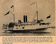 On November 26, 1898, the steamship SS Portland
left India Wharf
in Boston, Massachusetts
, for Portland, Maine
, on a regularly scheduled run. She never made it to port. None of the 192 passengers and crew survived the massive storm that wreaked havoc on New England's coast — a storm that was later dubbed "the Portland Gale" after the tragic loss of the ship.
For years, controversy reigned as to the location of the ill-fated ship. In the summer of 2002, Stellwagen Bank
National Marine Sanctuary
, joined by the National Undersea Research Center
at the University of Connecticut
(UConn), solved the mystery surrounding the Portlands location. Using data from American Underwater Search and Survey, they brought back images from the sea floor that conclusively identified the remains of the steamship Portland.
Researchers from NOAA
's Stellwagen Bank National Marine Sanctuary, along with the NOAA-UConn team and filmmakers from The Science Channel
, returned to the wreck of the famed 19th-century steamship from September 13–18, 2003. Kicking off the expedition to peer into the vessel's past and plan for its future, the team conducted the first surveys of the Portland since its location was confirmed in August 2002 within NOAA's Stellwagen Bank National Marine Sanctuary off the Massachusetts coast.
In addition to documenting the Portland, the expedition team investigated the wrecks of the Louise B. Crary and Frank A. Palmer, a pair of Boston-bound coal schooners that collided and sank in 1902 as a result of a navigational error. Like the Portland, the Crary and Palmer lie within the boundaries of Stellwagen Bank National Marine Sanctuary. Side-scan sonar images obtained in 2002 during a joint mission between NOAA and NURC-UConn revealed that the two large vessels plunged to the sea floor simultaneously, their bows locked together in a deadly embrace.
The researchers also investigated several nearby mystery wrecks that have yet to be fully identified.
, telegraph and electric lines were severed, and the ferris wheel
and roller coaster
in Hull were destroyed. The Duxbury pier was damaged, beaches were badly eroded, and dozens of ships and boats were wrecked on the beaches.
, is marked by four distinct bluffs, running from First Cliff on the northern end of the town's coast down to Fourth Cliff in the southern end. The area surrounding and including Fourth Cliff is called Humarock. Prior to the Portland Gale, the North River flowed south between Fourth Cliff and Marshfield, Massachusetts
, joining the South River and entering the ocean several kilometers to the south of the current opening. A thin strip of beach, which connected Third Cliff to Fourth Cliff, was breached by the storm, leaving Fourth Cliff an island. Eventually the old inlet has silted in, forcing the South River to flow north between Marshfield and Fourth Cliff, where it now joins the North River to enter the ocean between Third and Fourth Cliffs. Although Fourth Cliff is now connected by land to Marshfield, North of Rexhame Beach, there are no roads across the old inlet. As a result, Fourth Cliff and the rest of the Humarock part of Scituate are only accessible via the Marshfield Avenue and Julian Street bridges from Marshfield. The change to the course of the North River also increased the salinity of the large marsh area surrounding the current outlet, resulting in the loss of the valuable salt haying business.
New England
New England is a region in the northeastern corner of the United States consisting of the six states of Maine, New Hampshire, Vermont, Massachusetts, Rhode Island, and Connecticut...
on November 26 and 27, 1898. The storm formed when two low pressure area
Low pressure area
A low-pressure area, or "low", is a region where the atmospheric pressure at sea level is below that of surrounding locations. Low-pressure systems form under areas of wind divergence which occur in upper levels of the troposphere. The formation process of a low-pressure area is known as...
s merged off the coast of Virginia and travelled up the coast; at its peak, it produced a storm surge
Storm surge
A storm surge is an offshore rise of water associated with a low pressure weather system, typically tropical cyclones and strong extratropical cyclones. Storm surges are caused primarily by high winds pushing on the ocean's surface. The wind causes the water to pile up higher than the ordinary sea...
of about ten feet in Cohasset
Cohasset, Massachusetts
Cohasset is a town in Norfolk County, Massachusetts, United States, though it is not contiguous with the main body of the county. The population was 7,542 at the 2010 census.- History :...
harbor and hurricane-force winds in Nantucket. The storm killed more than 400 persons and sank more than 150 boats and ships. It also changed the course of the North River
North River (Massachusetts Bay)
The North River is a river, approximately long, in eastern Massachusetts, the United States. It is primarily a tidal river, formed by the confluence of the Indian Head River and Herring Brook. The North River forms the boundary between the towns of Norwell and Pembroke, Massachusetts, and...
, separating the Humarock
Humarock
Humarock is part of Scituate, Massachusetts, United States . Humarock is a pictureque seaside village surrounded by water and situated on Cape Cod Bay midway between Boston and Plymouth. It was separated from the rest of the town in the Portland Gale of 1898 in which the mouth of the North River...
portion of Scituate, Massachusetts
Scituate, Massachusetts
Scituate is a seacoast town in Plymouth County, Massachusetts, United States, on the South Shore, midway between Boston and Plymouth. The population was 18,133 at the 2010 census....
, from the rest of Scituate.
Loss of the SS Portland
Portland (Shipwreck)
The Portland is a historic shipwreck in Gloucester, Massachusetts. The S.S. Portland was built by New England Shipbuilding Co. in 1889 and sank in the Portland Gale of 1898 off of Cape Ann, killing 192 people....
left India Wharf
India Wharf
India Wharf was one of the largest commercial wharves in 19th-century Boston, Massachusetts. Designed by Charles Bulfinch, it was built in 1804 to accommodate international trade...
in Boston, Massachusetts
Massachusetts
The Commonwealth of Massachusetts is a state in the New England region of the northeastern United States of America. It is bordered by Rhode Island and Connecticut to the south, New York to the west, and Vermont and New Hampshire to the north; at its east lies the Atlantic Ocean. As of the 2010...
, for Portland, Maine
Portland, Maine
Portland is the largest city in Maine and is the county seat of Cumberland County. The 2010 city population was 66,194, growing 3 percent since the census of 2000...
, on a regularly scheduled run. She never made it to port. None of the 192 passengers and crew survived the massive storm that wreaked havoc on New England's coast — a storm that was later dubbed "the Portland Gale" after the tragic loss of the ship.
For years, controversy reigned as to the location of the ill-fated ship. In the summer of 2002, Stellwagen Bank
Stellwagen Bank National Marine Sanctuary
Stellwagen Bank National Marine Sanctuary is an 842-square-mile federally protected marine sanctuary located at the mouth of Massachusetts Bay, between Cape Cod and Cape Ann...
National Marine Sanctuary
United States National Marine Sanctuary
A U.S. National Marine Sanctuary is a federally-designated area within United States waters that protects areas of the marine environment with special conservation, recreational, ecological, historical, cultural, archeological, scientific, educational, or aesthetic qualities. The National Marine...
, joined by the National Undersea Research Center
National Undersea Research Center for the North Atlantic and Great Lakes
The National Undersea Research Center for the North Atlantic and Great Lakes is one of six undersea centers established by the National Oceanic and Atmospheric Administration's Undersea Research Program. It is co-located with the University of Connecticut’s Department of Marine Sciences...
at the University of Connecticut
University of Connecticut
The admission rate to the University of Connecticut is about 50% and has been steadily decreasing, with about 28,000 prospective students applying for admission to the freshman class in recent years. Approximately 40,000 prospective students tour the main campus in Storrs annually...
(UConn), solved the mystery surrounding the Portlands location. Using data from American Underwater Search and Survey, they brought back images from the sea floor that conclusively identified the remains of the steamship Portland.
Researchers from NOAA
National Oceanic and Atmospheric Administration
The National Oceanic and Atmospheric Administration , pronounced , like "noah", is a scientific agency within the United States Department of Commerce focused on the conditions of the oceans and the atmosphere...
's Stellwagen Bank National Marine Sanctuary, along with the NOAA-UConn team and filmmakers from The Science Channel
The Science Channel
Science is a United States cable, satellite and IPTV Television Network produced by Discovery Communications. Science features programming in the fields of space, technology, prehistory and animals.-History:...
, returned to the wreck of the famed 19th-century steamship from September 13–18, 2003. Kicking off the expedition to peer into the vessel's past and plan for its future, the team conducted the first surveys of the Portland since its location was confirmed in August 2002 within NOAA's Stellwagen Bank National Marine Sanctuary off the Massachusetts coast.
In addition to documenting the Portland, the expedition team investigated the wrecks of the Louise B. Crary and Frank A. Palmer, a pair of Boston-bound coal schooners that collided and sank in 1902 as a result of a navigational error. Like the Portland, the Crary and Palmer lie within the boundaries of Stellwagen Bank National Marine Sanctuary. Side-scan sonar images obtained in 2002 during a joint mission between NOAA and NURC-UConn revealed that the two large vessels plunged to the sea floor simultaneously, their bows locked together in a deadly embrace.
The researchers also investigated several nearby mystery wrecks that have yet to be fully identified.
Damage to coastal towns
Dozens of houses were destroyed in each of the towns along the South Shore of Massachusetts. Coastal railroads were damaged in Scituate and in HullHull, Massachusetts
Hull is a peninsula town in Plymouth County, Massachusetts, United States. The population was 10,293 at the 2010 census. Hull is the smallest town by land area in Plymouth County and the fourth smallest in the state...
, telegraph and electric lines were severed, and the ferris wheel
Ferris wheel
A Ferris wheel is a nonbuilding structure consisting of a rotating upright wheel with passenger cars attached to the rim in such a way that as the wheel turns, the cars are kept upright, usually by gravity.Some of the largest and most modern Ferris wheels have cars mounted on...
and roller coaster
Roller coaster
The roller coaster is a popular amusement ride developed for amusement parks and modern theme parks. LaMarcus Adna Thompson patented the first coasters on January 20, 1885...
in Hull were destroyed. The Duxbury pier was damaged, beaches were badly eroded, and dozens of ships and boats were wrecked on the beaches.
Change to the course of the North River
The southern coast of Scituate, MassachusettsScituate, Massachusetts
Scituate is a seacoast town in Plymouth County, Massachusetts, United States, on the South Shore, midway between Boston and Plymouth. The population was 18,133 at the 2010 census....
, is marked by four distinct bluffs, running from First Cliff on the northern end of the town's coast down to Fourth Cliff in the southern end. The area surrounding and including Fourth Cliff is called Humarock. Prior to the Portland Gale, the North River flowed south between Fourth Cliff and Marshfield, Massachusetts
Marshfield, Massachusetts
Marshfield is a town in Plymouth County, Massachusetts, United States, on Massachusetts's South Shore. The population was 25,132 at the 2010 census.See also: Green Harbor, Marshfield , Rexhame, Marshfield Hills, and Ocean Bluff and Brant Rock....
, joining the South River and entering the ocean several kilometers to the south of the current opening. A thin strip of beach, which connected Third Cliff to Fourth Cliff, was breached by the storm, leaving Fourth Cliff an island. Eventually the old inlet has silted in, forcing the South River to flow north between Marshfield and Fourth Cliff, where it now joins the North River to enter the ocean between Third and Fourth Cliffs. Although Fourth Cliff is now connected by land to Marshfield, North of Rexhame Beach, there are no roads across the old inlet. As a result, Fourth Cliff and the rest of the Humarock part of Scituate are only accessible via the Marshfield Avenue and Julian Street bridges from Marshfield. The change to the course of the North River also increased the salinity of the large marsh area surrounding the current outlet, resulting in the loss of the valuable salt haying business.