
Port Royal, South Carolina
Encyclopedia
Port Royal is a town in Beaufort County
, South Carolina
, United States
. Largely because of annexation of surrounding areas (including Parris Island), the population of Port Royal rose from 3,950 in 2000 to 10,678 in 2010, a 170% increase.http://www.islandpacket.com/2011/03/23/1594433/us-census-beaufort-county-grew.html##ixzz1HXEBl3DP As defined by the U.S. Census Bureau, Port Royal is included within the Beaufort Urban Cluster and the larger Hilton Head Island
–Beaufort
Micropolitan Statistical Area
.
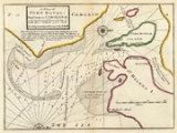
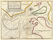
Frenchman Jean Ribault
explored the Port Royal Sound
waterways and harbours in 1562, and founded the short-lived settlement of Charlesfort there. The area later became the site of a Spanish
and still later Scottish
colony during the 17th century. In 1863, the Emancipation Proclamation was first read at Christmas under the Proclamation tree in Port Royal. Port Royal hosts the Soft Shell Crab Festival every year in late April during the short soft shell crab season.
The famous hurricane scene from the 1994 film Forrest Gump
was filmed in the town's dock area.
 Port Royal is located at 32°23′12"N 80°42′18"W (32.386572, -80.705007).
According to the United States Census Bureau
, the town has a total area of 57 square kilometres (22 sq mi), of which 49.1 square kilometres (19 sq mi) is land and 7.9 square kilometres (3.1 sq mi), or 13.92%, is water.
Port Royal was the site of the Naval Battle of Port Royal
during the Civil War. Later during the war, it was the site of the Port Royal Experiment
, which included most of the Sea Islands
in Union hands.
See also: http://history.sandiego.edu/gen/civilwar/07/portroyal.html
Port Royal is also home to Marine Corps Recruit Depot, Parris Island, SC, and Naval Hospital Beaufort.
of 2000, there were 3,950 people, 1,660 households, and 1,010 families residing in the town. The population density
was 1,017.3 people per square mile (393.1/km²). There were 1,792 housing units at an average density of 461.5 per square mile (178.3/km²). The racial makeup of the town was 64.18% White, 29.16% African American, 0.46% Native American, 1.70% Asian, 0.10% Pacific Islander, 1.92% from other races
, and 2.48% from two or more races. Hispanic or Latino of any race were 4.28% of the population.
There were 1,660 households out of which 30.2% had children under the age of 18 living with them, 43.6% were married couples
living together, 13.7% had a female householder with no husband present, and 39.1% were non-families. 31.1% of all households were made up of individuals and 7.8% had someone living alone who was 65 years of age or older. The average household size was 2.27 and the average family size was 2.86.
In the town the population was spread out with 22.9% under the age of 18, 14.6% from 18 to 24, 34.2% from 25 to 44, 17.3% from 45 to 64, and 11.0% who were 65 years of age or older. The median age was 30 years. For every 100 females there were 91.0 males. For every 100 females age 18 and over, there were 89.1 males.
The median income for a household in the town was $36,599, and the median income for a family was $40,867. Males had a median income of $26,942 versus $23,671 for females. The per capita income
for the town was $18,163. About 7.9% of families and 10.1% of the population were below the poverty line, including 11.0% of those under age 18 and 18.6% of those age 65 or over.
Beaufort County, South Carolina
-National protected areas:*Ernest F. Hollings ACE Basin National Wildlife Refuge *Pinckney Island National Wildlife Refuge-Demographics:As of the census of 2000, there were 155,215 people, 45,532 households, and 33,056 families residing in the county. The population density was 206 people per...
, South Carolina
South Carolina
South Carolina is a state in the Deep South of the United States that borders Georgia to the south, North Carolina to the north, and the Atlantic Ocean to the east. Originally part of the Province of Carolina, the Province of South Carolina was one of the 13 colonies that declared independence...
, United States
United States
The United States of America is a federal constitutional republic comprising fifty states and a federal district...
. Largely because of annexation of surrounding areas (including Parris Island), the population of Port Royal rose from 3,950 in 2000 to 10,678 in 2010, a 170% increase.http://www.islandpacket.com/2011/03/23/1594433/us-census-beaufort-county-grew.html##ixzz1HXEBl3DP As defined by the U.S. Census Bureau, Port Royal is included within the Beaufort Urban Cluster and the larger Hilton Head Island
Hilton Head Island, South Carolina
Hilton Head Island or Hilton Head is a resort town in Beaufort County, South Carolina, United States. It is north of Savannah, Georgia, and south of Charleston. The island gets its name from Captain William Hilton...
–Beaufort
Beaufort, South Carolina
Beaufort is a city in and the county seat of Beaufort County, South Carolina, United States. Chartered in 1711, it is the second-oldest city in South Carolina, behind Charleston. The city's population was 12,361 in the 2010 census. It is located in the Hilton Head Island-Beaufort Micropolitan...
Micropolitan Statistical Area
Hilton Head Island-Beaufort micropolitan area
The Hilton Head Island–Beaufort Micropolitan Statistical Area, as defined by the United States Census Bureau, is an area consisting of two counties in South Carolina, anchored by the town of Hilton Head Island and the city of Beaufort....
.
Frenchman Jean Ribault
Jean Ribault
Jean Ribault was a French naval officer, navigator, and a colonizer of what would become the southeastern United States. He was a major figure in the French attempts to colonize Florida...
explored the Port Royal Sound
Port Royal Sound
Port Royal Sound is a coastal sound, or inlet of the Atlantic Ocean, located in the Sea Islands region, in Beaufort County in the U.S. state of South Carolina...
waterways and harbours in 1562, and founded the short-lived settlement of Charlesfort there. The area later became the site of a Spanish
Spanish colonization of the Americas
Colonial expansion under the Spanish Empire was initiated by the Spanish conquistadores and developed by the Monarchy of Spain through its administrators and missionaries. The motivations for colonial expansion were trade and the spread of the Christian faith through indigenous conversions...
and still later Scottish
Scottish colonization of the Americas
Scottish colonization of the Americas consisted of a number of failed or abandoned Scottish settlements in North America, a colony at Darien, Panama, and a number of wholly or largely Scottish settlements made after the Acts of Union 1707, and those made by the enforced resettlement after the...
colony during the 17th century. In 1863, the Emancipation Proclamation was first read at Christmas under the Proclamation tree in Port Royal. Port Royal hosts the Soft Shell Crab Festival every year in late April during the short soft shell crab season.
The famous hurricane scene from the 1994 film Forrest Gump
Forrest Gump
Forrest Gump is a 1994 American epic comedy-drama romance film based on the 1986 novel of the same name by Winston Groom. The film was directed by Robert Zemeckis, starring Tom Hanks, Robin Wright and Gary Sinise...
was filmed in the town's dock area.
Geography
According to the United States Census Bureau
United States Census Bureau
The United States Census Bureau is the government agency that is responsible for the United States Census. It also gathers other national demographic and economic data...
, the town has a total area of 57 square kilometres (22 sq mi), of which 49.1 square kilometres (19 sq mi) is land and 7.9 square kilometres (3.1 sq mi), or 13.92%, is water.
Port Royal was the site of the Naval Battle of Port Royal
Battle of Port Royal
The Battle of Port Royal was one of the earliest amphibious operations of the American Civil War, in which a United States Navy fleet and United States Army expeditionary force captured Port Royal Sound, South Carolina, between Savannah, Georgia and Charleston, South Carolina, on November 7, 1861...
during the Civil War. Later during the war, it was the site of the Port Royal Experiment
Port Royal Experiment
The Port Royal Experiment was a program begun during the American Civil War in which former slaves successfully worked on the land abandoned by plantation owners. In 1861 the Union liberated the Sea Islands off the coast of South Carolina and their main harbor, Port Royal. The white residents fled,...
, which included most of the Sea Islands
Sea Islands
The Sea Islands are a chain of tidal and barrier islands on the Atlantic Ocean coast of the United States. They number over 100, and are located between the mouths of the Santee and St. Johns Rivers along the coast of the U.S...
in Union hands.
See also: http://history.sandiego.edu/gen/civilwar/07/portroyal.html
Port Royal is also home to Marine Corps Recruit Depot, Parris Island, SC, and Naval Hospital Beaufort.
Demographics
As of the censusCensus
A census is the procedure of systematically acquiring and recording information about the members of a given population. It is a regularly occurring and official count of a particular population. The term is used mostly in connection with national population and housing censuses; other common...
of 2000, there were 3,950 people, 1,660 households, and 1,010 families residing in the town. The population density
Population density
Population density is a measurement of population per unit area or unit volume. It is frequently applied to living organisms, and particularly to humans...
was 1,017.3 people per square mile (393.1/km²). There were 1,792 housing units at an average density of 461.5 per square mile (178.3/km²). The racial makeup of the town was 64.18% White, 29.16% African American, 0.46% Native American, 1.70% Asian, 0.10% Pacific Islander, 1.92% from other races
Race (United States Census)
Race and ethnicity in the United States Census, as defined by the Federal Office of Management and Budget and the United States Census Bureau, are self-identification data items in which residents choose the race or races with which they most closely identify, and indicate whether or not they are...
, and 2.48% from two or more races. Hispanic or Latino of any race were 4.28% of the population.
There were 1,660 households out of which 30.2% had children under the age of 18 living with them, 43.6% were married couples
Marriage
Marriage is a social union or legal contract between people that creates kinship. It is an institution in which interpersonal relationships, usually intimate and sexual, are acknowledged in a variety of ways, depending on the culture or subculture in which it is found...
living together, 13.7% had a female householder with no husband present, and 39.1% were non-families. 31.1% of all households were made up of individuals and 7.8% had someone living alone who was 65 years of age or older. The average household size was 2.27 and the average family size was 2.86.
In the town the population was spread out with 22.9% under the age of 18, 14.6% from 18 to 24, 34.2% from 25 to 44, 17.3% from 45 to 64, and 11.0% who were 65 years of age or older. The median age was 30 years. For every 100 females there were 91.0 males. For every 100 females age 18 and over, there were 89.1 males.
The median income for a household in the town was $36,599, and the median income for a family was $40,867. Males had a median income of $26,942 versus $23,671 for females. The per capita income
Per capita income
Per capita income or income per person is a measure of mean income within an economic aggregate, such as a country or city. It is calculated by taking a measure of all sources of income in the aggregate and dividing it by the total population...
for the town was $18,163. About 7.9% of families and 10.1% of the population were below the poverty line, including 11.0% of those under age 18 and 18.6% of those age 65 or over.