
Port Orford, Oregon
Encyclopedia
Port Orford is a city in Curry County
, Oregon
, United States
. It is on the southern Oregon Coast
, at the northern end of what coastal Oregonians call the Banana Belt
, because the weather from Port Orford south is noticeably warmer than the weather north of nearby Cape Blanco
. The population was 1,153 at the 2000 census.
The city takes its name from George Vancouver
's original name for Cape Blanco, which he named for George, Earl of Orford
, "a much-respected friend."
 The first European settlers, led by Captain William Tichenor, arrived in 1851. Tichenor, needing to return to the north for supplies, left a group of nine men behind. However, members of the local Qua-to-mah tribe reacted with hostility to the newcomers, who they felt were encroaching on their territory. Taking up a position on a nearby seastack, now known as Battle Rock, the settlers were attacked by a band of more than 100 Qua-to-mahs. Twenty-three natives were killed, and two of Tichenor's men were wounded in the ensuing conflict. Soon afterward, a truce was called between the two groups, when the settlers told the natives that they would be leaving in 14 days. For the next two weeks, the settlers did not see any members of the local tribe. However, after the 14th day, an even larger band of natives than the first attacked. During the battle, the chief of the tribe was killed. Retreating with their dead chief, the tribe set up camp nearby. The settlers soon fled north under cover of darkness.
 Port Orford was formally founded in 1856. It would serve as a receiving port for mercantile and fishing. The port district was formally set up more than 50 years later, in 1911. It was during this time that Port Orford would become a shipping port for local Port Orford Cedar. The port was sold in 1935. However, in 1957, a little more than 100 years since the city's founding, the port was bought back. Eventually, Port Orford would see a decline in fishing and the shipping of timber would cease.
In October 1941, then-mayor Gilbert Gable, frustrated with the poor condition of the state roads around Port Orford, which hampered economic development, suggested that a number of counties along the Oregon
and California
state border should secede and create the State of Jefferson. This movement came to an end with U.S. involvement in World War II
.
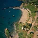
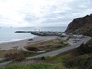
The port is an open-water dock (no natural protection) and boasts the only drydock port on the West Coast. The fishing boats are lifted in and out of the water by operated cranes
, set on custom-made dollies and parked in rows on the dock. As a result, it is known as a "dolly dock."
 Port Orford is a small port hamlet located 28 miles (45.1 km) north of Gold Beach
, Oregon, and 27 miles (43.5 km) south of Bandon-by-the-Sea, Oregon (home of the Bandon Dunes Golf Resort), on U.S. Route 101
. The city is tucked between the Pacific Ocean and the Siskiyou National Forest.
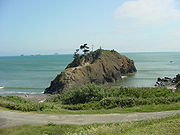
Elevated Quaternary marine terraces deposited during the last major interglacial period have given rise to topographic features surrounding the area. The Port Orford Heads State Park
is located in Port Orford on a scenic headland where the historic Coast Guard
lifeboat station operated from 1930 to 1970. The city is adjacent to Cape Blanco
, a headland consisting of the Cape Blanco terrace dated at 80,000 years old, and is considered by many to be the westernmost point in the Lower 48 states. (However, this is disputed. See Cape Alava
in Washington.) The city is located north of Humbug Mountain
, which is considered to be the tallest mountain in the Lower 48 to descend directly into an ocean
.
According to the United States Census Bureau
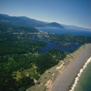
, Port Orford has a total area of 1.6 square miles (4.1 km²), of which 1.6 square miles (4.1 km²) is land and 0.04 square mile (0.1035995244 km²) is water. Garrison Lake, a 130 acre (0.5260918 km²) freshwater lake that is annually stocked with trout, is a natural lagoon
that exists within city boundaries, along with a large amount of wetlands.
At 124 degrees, 29 minutes, 53 seconds west longitude, Port Orford is the westernmost city in the contiguous United States
.
of 2000, there were 1,153 people, 571 households, and 311 families residing in the city. The population density
was 719.1 people per square mile (278.2/km²). There were 662 housing units at an average density of 412.9 per square mile (159.7/km²). The racial makeup of the city was 95.40% White, 0.09% African American, 1.39% Native American, 0.26% Asian, 0.17% Pacific Islander, 0.87% from other races
, and 1.82% from two or more races. Hispanic or Latino of any race were 2.60% of the population.
There were 571 households out of which 19.6% had children under the age of 18 living with them, 44.0% were married couples
living together, 9% had a female householder with no husband present, and 45% were non-families. 39% of all households were made up of individuals and 18.2% had someone living alone who was 65 years of age or older. The average household size was 2 people and the average family size was 2.66.
In the city the population was spread out with 18.8% under the age of 18, 3.4% from 18 to 24, 19.7% from 25 to 44, 30.8% from 45 to 64, and 27.3% who were 65 years of age or older. The median age was 50 years. For every 100 females there were 92.2 males.
The median income for a household in the city was $23,289, and the median income for a family was $29,653. Males had a median income of $35,221 versus $15,179 for females. The per capita income
for the city was $16,442. About 16.1% of families and 17.8% of the population were below the poverty line, including 21.9% of those under age 18 and 9.2% of those age 65 or over.
.
Curry County, Oregon
Curry County is a county located in the U.S. state of Oregon. In 2010, its population was 22,364. The county is named for George Law Curry, a governor of the Oregon Territory. The seat of the county is Gold Beach.-Economy:...
, Oregon
Oregon
Oregon is a state in the Pacific Northwest region of the United States. It is located on the Pacific coast, with Washington to the north, California to the south, Nevada on the southeast and Idaho to the east. The Columbia and Snake rivers delineate much of Oregon's northern and eastern...
, United States
United States
The United States of America is a federal constitutional republic comprising fifty states and a federal district...
. It is on the southern Oregon Coast
Oregon Coast
The Oregon Coast is a region of the U.S. state of Oregon. It runs generally north-south along the Pacific Ocean, forming the western border of the state; the region is bounded to the east by the Oregon Coast Range. The Oregon Coast stretches approximately from the Columbia River in the north to...
, at the northern end of what coastal Oregonians call the Banana Belt
Banana belt
"Banana belt" is an informal geographic term used to describe a segment of a larger geographic region which enjoys warmer weather conditions than the region as a whole, especially in the wintertime...
, because the weather from Port Orford south is noticeably warmer than the weather north of nearby Cape Blanco
Cape Blanco (Oregon)
Cape Blanco is a prominent headland on the Pacific Ocean coast of southwestern Oregon in the United States, forming the westernmost point in the state. It contests with Cape Alava in Washington for the title of westernmost point in the contiguous United States...
. The population was 1,153 at the 2000 census.
The city takes its name from George Vancouver
George Vancouver
Captain George Vancouver RN was an English officer of the British Royal Navy, best known for his 1791-95 expedition, which explored and charted North America's northwestern Pacific Coast regions, including the coasts of contemporary Alaska, British Columbia, Washington and Oregon...
's original name for Cape Blanco, which he named for George, Earl of Orford
Earl of Orford
Earl of Orford is a title that has been created three times. The first creation came in the Peerage of England in 1697 in favour of the naval commander Edward Russell, who served three times as First Lord of the Admiralty. He was created Baron Shingay and Viscount Barfleur at the same time...
, "a much-respected friend."
History
Before the arrival of European settlers, the Port Orford area was inhabited by Tututni peoples. The Tututni languages were a part of the Pacific Coast Athabaskan language family.In October 1941, then-mayor Gilbert Gable, frustrated with the poor condition of the state roads around Port Orford, which hampered economic development, suggested that a number of counties along the Oregon
Oregon
Oregon is a state in the Pacific Northwest region of the United States. It is located on the Pacific coast, with Washington to the north, California to the south, Nevada on the southeast and Idaho to the east. The Columbia and Snake rivers delineate much of Oregon's northern and eastern...
and California
California
California is a state located on the West Coast of the United States. It is by far the most populous U.S. state, and the third-largest by land area...
state border should secede and create the State of Jefferson. This movement came to an end with U.S. involvement in World War II
World War II
World War II, or the Second World War , was a global conflict lasting from 1939 to 1945, involving most of the world's nations—including all of the great powers—eventually forming two opposing military alliances: the Allies and the Axis...
.
The port is an open-water dock (no natural protection) and boasts the only drydock port on the West Coast. The fishing boats are lifted in and out of the water by operated cranes
Crane (machine)
A crane is a type of machine, generally equipped with a hoist, wire ropes or chains, and sheaves, that can be used both to lift and lower materials and to move them horizontally. It uses one or more simple machines to create mechanical advantage and thus move loads beyond the normal capability of...
, set on custom-made dollies and parked in rows on the dock. As a result, it is known as a "dolly dock."
Geography
Gold Beach, Oregon
Gold Beach is a city in and the county seat of Curry County, Oregon, United States, on the Oregon Coast. The population was 1,897 at the 2000 census.-History:...
, Oregon, and 27 miles (43.5 km) south of Bandon-by-the-Sea, Oregon (home of the Bandon Dunes Golf Resort), on U.S. Route 101
U.S. Route 101
U.S. Route 101, or U.S. Highway 101, is an important north–south U.S. highway that runs through the states of California, Oregon, and Washington, on the West Coast of the United States...
. The city is tucked between the Pacific Ocean and the Siskiyou National Forest.
Elevated Quaternary marine terraces deposited during the last major interglacial period have given rise to topographic features surrounding the area. The Port Orford Heads State Park
Port Orford Heads State Park
Port Orford Heads State Park, a coastal state park in northwest Curry County, Oregon, in the city of Port Orford. It was established in 1976, and is administered by the Oregon Parks and Recreation Department.-Location:...
is located in Port Orford on a scenic headland where the historic Coast Guard
United States Coast Guard
The United States Coast Guard is a branch of the United States Armed Forces and one of the seven U.S. uniformed services. The Coast Guard is a maritime, military, multi-mission service unique among the military branches for having a maritime law enforcement mission and a federal regulatory agency...
lifeboat station operated from 1930 to 1970. The city is adjacent to Cape Blanco
Cape Blanco (Oregon)
Cape Blanco is a prominent headland on the Pacific Ocean coast of southwestern Oregon in the United States, forming the westernmost point in the state. It contests with Cape Alava in Washington for the title of westernmost point in the contiguous United States...
, a headland consisting of the Cape Blanco terrace dated at 80,000 years old, and is considered by many to be the westernmost point in the Lower 48 states. (However, this is disputed. See Cape Alava
Cape Alava
Cape Alava, in Clallam County, Washington, U.S.A., is the westernmost point in the contiguous 48 states, with a longitude of . The westernmost point is located in Olympic National Park and the Ozette Indian Reservation...
in Washington.) The city is located north of Humbug Mountain
Humbug Mountain
Humbug Mountain lies on the southern coast of the U.S. state of Oregon. It is located about south of Port Orford, and north of Gold Beach, on the Pacific Ocean. The mountain is completely within Humbug Mountain State Park, and U.S. Route 101 passes by its northern base...
, which is considered to be the tallest mountain in the Lower 48 to descend directly into an ocean
Ocean
An ocean is a major body of saline water, and a principal component of the hydrosphere. Approximately 71% of the Earth's surface is covered by ocean, a continuous body of water that is customarily divided into several principal oceans and smaller seas.More than half of this area is over 3,000...
.
According to the United States Census Bureau
United States Census Bureau
The United States Census Bureau is the government agency that is responsible for the United States Census. It also gathers other national demographic and economic data...
, Port Orford has a total area of 1.6 square miles (4.1 km²), of which 1.6 square miles (4.1 km²) is land and 0.04 square mile (0.1035995244 km²) is water. Garrison Lake, a 130 acre (0.5260918 km²) freshwater lake that is annually stocked with trout, is a natural lagoon
Lagoon
A lagoon is a body of shallow sea water or brackish water separated from the sea by some form of barrier. The EU's habitat directive defines lagoons as "expanses of shallow coastal salt water, of varying salinity or water volume, wholly or partially separated from the sea by sand banks or shingle,...
that exists within city boundaries, along with a large amount of wetlands.
At 124 degrees, 29 minutes, 53 seconds west longitude, Port Orford is the westernmost city in the contiguous United States
Contiguous United States
The contiguous United States are the 48 U.S. states on the continent of North America that are south of Canada and north of Mexico, plus the District of Columbia....
.
Demographics
As of the censusCensus
A census is the procedure of systematically acquiring and recording information about the members of a given population. It is a regularly occurring and official count of a particular population. The term is used mostly in connection with national population and housing censuses; other common...
of 2000, there were 1,153 people, 571 households, and 311 families residing in the city. The population density
Population density
Population density is a measurement of population per unit area or unit volume. It is frequently applied to living organisms, and particularly to humans...
was 719.1 people per square mile (278.2/km²). There were 662 housing units at an average density of 412.9 per square mile (159.7/km²). The racial makeup of the city was 95.40% White, 0.09% African American, 1.39% Native American, 0.26% Asian, 0.17% Pacific Islander, 0.87% from other races
Race (United States Census)
Race and ethnicity in the United States Census, as defined by the Federal Office of Management and Budget and the United States Census Bureau, are self-identification data items in which residents choose the race or races with which they most closely identify, and indicate whether or not they are...
, and 1.82% from two or more races. Hispanic or Latino of any race were 2.60% of the population.
There were 571 households out of which 19.6% had children under the age of 18 living with them, 44.0% were married couples
Marriage
Marriage is a social union or legal contract between people that creates kinship. It is an institution in which interpersonal relationships, usually intimate and sexual, are acknowledged in a variety of ways, depending on the culture or subculture in which it is found...
living together, 9% had a female householder with no husband present, and 45% were non-families. 39% of all households were made up of individuals and 18.2% had someone living alone who was 65 years of age or older. The average household size was 2 people and the average family size was 2.66.
In the city the population was spread out with 18.8% under the age of 18, 3.4% from 18 to 24, 19.7% from 25 to 44, 30.8% from 45 to 64, and 27.3% who were 65 years of age or older. The median age was 50 years. For every 100 females there were 92.2 males.
The median income for a household in the city was $23,289, and the median income for a family was $29,653. Males had a median income of $35,221 versus $15,179 for females. The per capita income
Per capita income
Per capita income or income per person is a measure of mean income within an economic aggregate, such as a country or city. It is calculated by taking a measure of all sources of income in the aggregate and dividing it by the total population...
for the city was $16,442. About 16.1% of families and 17.8% of the population were below the poverty line, including 21.9% of those under age 18 and 9.2% of those age 65 or over.
Education
The city is served by the Port Orford-Langlois School District, which includes Pacific High SchoolPacific High School (Port Orford, Oregon)
Pacific High School is a public high school in Port Orford, Oregon, United States.-Academics:In 2008, 82% of the school's seniors received their high school diploma. Of 34 students, 28 graduated, 3 dropped out, and 3 received a modified diploma....
.