

Popponesset Bay
Encyclopedia
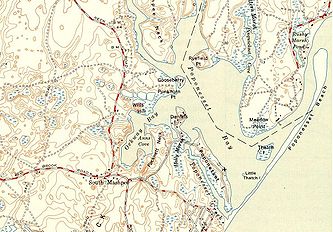
Bay
A bay is an area of water mostly surrounded by land. Bays generally have calmer waters than the surrounding sea, due to the surrounding land blocking some waves and often reducing winds. Bays also exist as an inlet in a lake or pond. A large bay may be called a gulf, a sea, a sound, or a bight...
s located at the towns of Mashpee
Mashpee, Massachusetts
Mashpee is a town in Barnstable County, Massachusetts, United States. The population was 14,006 as of 2010.For geographic and demographic information on specific parts of the town of Mashpee, please see the articles on Mashpee Neck, Monomoscoy Island, New Seabury, Popponesset, Popponesset Island,...
(north & west) and Barnstable
Barnstable, Massachusetts
Barnstable is a city, referred to as the Town of Barnstable, in the U.S. state of Massachusetts and the county seat of Barnstable County. Barnstable is the largest community, both in land area and population, on Cape Cod. The town contains seven villages within its boundaries...
(east), on Cape Cod
Cape Cod
Cape Cod, often referred to locally as simply the Cape, is a cape in the easternmost portion of the state of Massachusetts, in the Northeastern United States...
, Massachusetts
Massachusetts
The Commonwealth of Massachusetts is a state in the New England region of the northeastern United States of America. It is bordered by Rhode Island and Connecticut to the south, New York to the west, and Vermont and New Hampshire to the north; at its east lies the Atlantic Ocean. As of the 2010...
with a southern shore bounded by water from
Nantucket Sound
Nantucket Sound
Nantucket Sound is a roughly triangular area of the Atlantic Ocean offshore from the U.S. state of Massachusetts. It is long and wide, and is enclosed by Cape Cod on the north, Nantucket on the south, and Martha's Vineyard on the west. Between Cape Cod and Martha's Vineyard it is connected to the...
.
Popponesset Bay has the following tributary sub-embayments:
- Ockway Bay
- Shoestring Bay
- Mashpee River Estuary
- Pinquickset Cove
The bay system is fed by the Mashpee River
Mashpee River
The Mashpee River is a tidal river on Cape Cod in Mashpee, Massachusetts.The river arises in Mashpee and Wakeby Ponds, flows south a short distance, and drains into Pirate's Cove on Popponesset Bay on the Nantucket Sound...
and Santuit River
Santuit River
The Santuit River, also known as the Cotuit River, is a river on the border between Mashpee and Cotuit, Massachusetts on Cape Cod.The river flows southwards from the southern end of Santuit Pond into Popponesset Bay on the south shore of Cape Cod.The river was a vigorous herring/alewife run and...
. Popponesset Creek
Popponesset Creek
Popponesset Creek is a small waterway in Mashpee, Massachusetts on Cape Cod. On both ends, it connects with Popponesset Bay.Popponesset Creek runs from Holly Marsh down to Popponesset Peninsula and serves to separate Popponesset Island from the bay...
is not a tributary but rather connects with the bay on both ends and separates Popponesset Island from the mainland.
The bay’s watershed
Drainage basin
A drainage basin is an extent or an area of land where surface water from rain and melting snow or ice converges to a single point, usually the exit of the basin, where the waters join another waterbody, such as a river, lake, reservoir, estuary, wetland, sea, or ocean...
is distributed among the towns of Mashpee, Barnstable and Sandwich, Massachusetts
Sandwich, Massachusetts
Sandwich is a town in Barnstable County, Massachusetts, United States. The population was 20,675 at the 2010 census. The Town Hall is located right next to the Dexter Grist Mill, in the historic district of town....
. The town of Sandwich does have jurisdiction over land and associated land uses in the uppermost portions of the Popponesset Bay watershed. Portions of the Popponesset Bay watershed that exist within the Town of Sandwich are mostly situated above the Mashpee and Wakeby Ponds
Mashpee and Wakeby Ponds
Mashpee Pond and Wakeby Pond are adjoining ponds in Mashpee and Sandwich, Massachusetts. When considered together, these two ponds cover and constitute the largest freshwater pond on Cape Cod. This pair is deep at its deepest point....
.
Popponesset Bay has experienced problems with eutrophication
Eutrophication
Eutrophication or more precisely hypertrophication, is the movement of a body of water′s trophic status in the direction of increasing plant biomass, by the addition of artificial or natural substances, such as nitrates and phosphates, through fertilizers or sewage, to an aquatic system...
from high nitrogen
Nitrogen
Nitrogen is a chemical element that has the symbol N, atomic number of 7 and atomic mass 14.00674 u. Elemental nitrogen is a colorless, odorless, tasteless, and mostly inert diatomic gas at standard conditions, constituting 78.08% by volume of Earth's atmosphere...
loads in the groundwater
Groundwater
Groundwater is water located beneath the ground surface in soil pore spaces and in the fractures of rock formations. A unit of rock or an unconsolidated deposit is called an aquifer when it can yield a usable quantity of water. The depth at which soil pore spaces or fractures and voids in rock...
and runoff from the watersheds.
The present bay results from tidal flooding of drowned river valleys formed primarily by the Mashpee and Santuit Rivers as a result of a risen sea level. The Bay is separated from Nantucket Sound by Popponesset Peninsula
Popponesset Peninsula
Popponesset Peninsula is a spit of land in Cape Cod, Massachusetts which extends from the southwestern shore of Popponesset Bay and separates it from Nantucket Sound....
, a barrier spit which extends from the southwestern shore and is mostly occupied by Popponesset Beach. Popponesset Beach is known to the locals as simply "The Spit."
The bay exchanges tidal water with Nantucket Sound through a single maintained inlet
Inlet
An inlet is a narrow body of water between islands or leading inland from a larger body of water, often leading to an enclosed body of water, such as a sound, bay, lagoon or marsh. In sea coasts an inlet usually refers to the actual connection between a bay and the ocean and is often called an...
. The shore to the north of the inlet has been stabilized with riprap
Riprap
Riprap — also known as rip rap, rubble, shot rock or rock armour or "Rip-rap" — is rock or other material used to armor shorelines, streambeds, bridge abutments, pilings and other shoreline structures against scour, water or ice erosion.It is made from a variety of rock types, commonly granite or...
as has the heavily residential southern portion of Popponesset Beach. The current spit is significantly shorter than seen in the 1880 Barnstable County survey.
The village of Popponesset
Popponesset, Massachusetts
Popponesset is a census-designated place in the town of Mashpee in Barnstable County, Massachusetts, United States. The population was 310 at the 2000 census.-Geography:Popponesset is located at ....
takes its name from these waters.