
Popolopen
Encyclopedia
Popolopen is the name of several related landmarks mainly within the Hudson Highlands
of Orange County, New York
. These include a mountain, Popolopen Torne—or simply "The Torne" and a short and steep-sided nearby valley officially called Hell Hole, but often Popolopen Gorge. Popolopen Creek runs through this valley and Popolopen Bridge spans its mouth at the Hudson River
and is crossed by Route 9W. Popolopen Lake lies at the headwaters of its namesake creek. Despite local usage, the United States Board on Geographical Names recognizes only the lake, creek and bridge as bearing the name "Popolopen." http://geonames.usgs.gov/pls/gnispublic/f?p=115:2:1034126179372169::NO:RP::
 Popolopen Torne (officially called merely "The Torne") is a small mountain with a relatively sharp and bald peak, part of the Hudson Highlands
, with a summit 942 feet (287.12 meters) above sea level. The blue-blazed
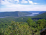
, horseshoe-shaped Timp Torne trail makes a loop from Mine Torne Road to the summit and back again. Its short and steep ascent for hikers affords 360° views of the Hudson River
, West Point
, Bear Mountain
, and Harriman State Park. U.S. Route 6
passes through the valley formed between Popolopen Torne and Bear Mountain just before it reaches the Bear Mountain Bridge
.
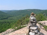
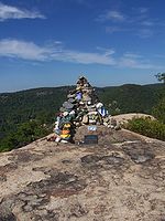 A cairn
stands at the summit as a memorial to members of the U.S. Armed Forces. Hikers can carry rocks with them from the base of the mountain to the top and add them to the pile, and rocks are often painted with unit insignia and other messages. A homemade sign detailing its creation and meaning was originally attached to the monument, later replaced by an engraved marble plaque.
near New York State Route 293
. Camp Buckner and Camp Natural Bridge are located at Popolopen, and the lake is a common site for training and recreation. In the late nineteenth and early twentieth century, cadets from West Point would leave the reservation each August for a three-day war game
dubbed "the Battle of Popolopen". The lake was also the site of a summer camp and was used exhaustively to supply water for nearby mining operations. During World War II
, after the land was purchased for exclusive military use, the remains of the summer retreat became Camp Popolopen, a POW
camp for German prisoners. After the war, the name was changed to Camp Buckner.
The lake comprises the largest body of water at West Point, and is used for aquatic training such as scuba diving
and amphibious assault.
Lake Popolopen is the setting for the murder mystery Dress Gray by Lucian Truscott IV, grandson of U.S. Army General Lucian Truscott, Jr
.
 Popolopen Creek—also called Popolopen Brook—is a stream, fed mainly by Lake Popolopen, Stillwell Lake, and Weyant's Pond, eventually draining into the Hudson River. It runs mainly through West Point and ends in a gorge between Bear Mountain and Popolopen Torne, officially called Hell Hole and popularly known, somewhat interchangeably, as Popolopen Gorge.
Local usage applies "Hell Hole" to a series of small plunge pools within this gorge, although the usage contradicts the U.S. Geological Survey maps and other widely used sources.
In a paper published in 1950, the geologist K.E. Lowe wrote that the gorge known as Hell Hole is the result of a fault within a regional intrusion of crystalline rock called Storm King granite. Yet he added: "Despite painstaking investigation, the writer found only one outcrop revealing direct evidence of faulting. A badly weathered, unhealed zone of crushed Storm King granite is exposed in the south wall of upper Hell Hole. Its continuation is unfortunately lost under debris from the construction of [highway] US 6 which mantles most of the Bear Mountain side of the valley." http://google.com/scholar?q=cache:ZG5I5WOuHJ0J:scholar.google.com/+popolopen+%22Hell+Hole%22&hl=en&as_sdt=2000
For most of its length through the gorge, the creek is narrow and extremely rocky, with fast moving rapids and several waterfalls. It can only be reached on foot and is not generally navigable by boat.
The red-blazed Popolopen Gorge Trail runs along the south side of the creek to a foot bridge just south of Popolopen Torne. Here, it joins the blue-blazed Timp-Torne, 1777 West and 1779 Trails. These run along the north side of the creek from Hell Hole to the bridge, with the Timp-Torne detouring over the summit of Popolopen Torne. They cross the footbridge and join the Popolopen Gorge Trail to detour around West Point property, and the combined trails turn southwest and follow the valley of Queensboro Brook. On October 6, 2002, New York Governor George Pataki
dedicated a long suspension foot bridge which spans the creek a short distance further downstream. The foot bridge connects the Twin Forts Trail to its intersection with the Appalachian Trail
on the western side of the Bear Mountain Bridge
.
Some few advanced kayakers are said to have run through this gorge at flood stage, but the rather dangerous and doubtful nature of this enterprise has helped make such descents quite unusual.
On 8 June 2008, a man was arrested for parachuting into the creek from the 9W overpass, called Popolopen Bridge. He was charged with disorderly conduct, unauthorized use of an aircraft (the parachute), and unauthorized swimming. His two assistants were also charged with unauthorized swimming for pulling him out of the water.
A girl of sixteen suffered a head injury when she fell from a cliff over Hell Hole on 20 July 2008 and died three days later. She had been with a swimming party although swimming in the creek is forbidden by park authorities.
 During the American Revolution, the mouth of Popolopen Creek was spanned by a pontoon bridge
http://books.google.com/books?id=ADAbAQAAIAAJ&pg=PA293&lpg=PA293&dq=popolopen+bridge&source=bl&ots=4PiTU_2v2w&sig=vaFaoHjGSYwieqgct1tazRBeZeo&hl=en&ei=ANFdS4qKNIq0NrTexZAP&sa=X&oi=book_result&ct=result&resnum=8&ved=0CB4Q6AEwBzgK#v=onepage&q=popolopen%20bridge&f=false. Much later,
the road north from Hessian Lake to Fort Montgomery
once crossed the lower part of the gorge by an iron bridge. The steep descents into the gorge and sharp turns onto this bridge made it dangerous for auto traffic, and the road (then Route 3, renumbered
U.S. Route 9W
in 1930) was rerouted over a high steel viaduct further downstream, near the site of Fort Montgomery
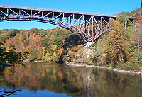
, in 1916. Another bridge was built immediately adjacent in 1936.
Called Popolopen Bridge, the 1936 structure is of the deck truss design, more than 600 feet long, 48 feet wide, and rises about 150 feet above the mouth of Popolopen Creek. As of 2000, its average daily traffic was about 18,000 vehicles. Although rehabilitation was performed in 1992, additional work aimed at repairs was completed in 2007. http://bridgehunter.com/ny/orange/popolopen/
http://www.northcountrygazette.org/2007/12/26/nys-deck-truss-bridges-deemed-safe-for-travel/.
The 1916 bridge was demolished in the 1950s, although its high stone abutments remain.
ary era into the twentieth century, operating a narrow gauge
railroad along the creek as far as the eastern slopes of Popolopen Torne. The mine site is now submerged under Stillwell Lake. Queensboro Furnace, located just above the outlet of Queensboro Brook into the creek, smelted iron during the late eighteenth century. The remains of the furnace have been preserved but are located on the grounds of the West Point Military Reservation.
 A grist mill was built in 1799 by Eugene Lucet, just above the later site of the Route 9W crossing. A dam was built upstream in 1901, just above the old Hell Hole bridge, to improve the water supply to the mill. The dam is still intact today, and water pools behind it when the creek flow exceeds that of the outlet near the bottom. This intermittent body of water is marked Roe Pond on some maps although at least one other pond in the area has that name. The mill was later converted to a hydroelectric plant, and was demolished in the 1950s.
An aqueduct
was built on the north side of the gorge in 1906 to bring water from Queensboro Brook and Popolopen Creek to West Point. Another was built on the south side in 1929–30 to supply Bear Mountain State Park with water from Queensboro Lake. Repairs to the latter were to result in the closing of the combined Popolopen Gorge–1777 West–1779–Timp-Torne Trails from the fall of 2008 to spring 2009.
Hudson Highlands
The Hudson Highlands are mountains on both sides of the Hudson River in the U.S. state of New York, between Newburgh Bay and Haverstraw Bay, which form the northern region of the New York - New Jersey Highlands....
of Orange County, New York
Orange County, New York
Orange County is a county located in the U.S. state of New York. It is part of the Poughkeepsie–Newburgh–Middletown, NY Metropolitan Statistical Area and is located at the northern reaches of the New York metropolitan area. The county sits in the state's scenic Mid-Hudson Region of the Hudson Valley...
. These include a mountain, Popolopen Torne—or simply "The Torne" and a short and steep-sided nearby valley officially called Hell Hole, but often Popolopen Gorge. Popolopen Creek runs through this valley and Popolopen Bridge spans its mouth at the Hudson River
Hudson River
The Hudson is a river that flows from north to south through eastern New York. The highest official source is at Lake Tear of the Clouds, on the slopes of Mount Marcy in the Adirondack Mountains. The river itself officially begins in Henderson Lake in Newcomb, New York...
and is crossed by Route 9W. Popolopen Lake lies at the headwaters of its namesake creek. Despite local usage, the United States Board on Geographical Names recognizes only the lake, creek and bridge as bearing the name "Popolopen." http://geonames.usgs.gov/pls/gnispublic/f?p=115:2:1034126179372169::NO:RP::
Popolopen Torne
Hudson Highlands
The Hudson Highlands are mountains on both sides of the Hudson River in the U.S. state of New York, between Newburgh Bay and Haverstraw Bay, which form the northern region of the New York - New Jersey Highlands....
, with a summit 942 feet (287.12 meters) above sea level. The blue-blazed
Trail blazing
Trail blazing, or trailblazing, is the practice of marking paths in outdoor recreational areas with blazes, markings that follow each other at certain — though not necessarily exactly defined — distances and mark the direction of the trail...
, horseshoe-shaped Timp Torne trail makes a loop from Mine Torne Road to the summit and back again. Its short and steep ascent for hikers affords 360° views of the Hudson River
Hudson River
The Hudson is a river that flows from north to south through eastern New York. The highest official source is at Lake Tear of the Clouds, on the slopes of Mount Marcy in the Adirondack Mountains. The river itself officially begins in Henderson Lake in Newcomb, New York...
, West Point
United States Military Academy
The United States Military Academy at West Point is a four-year coeducational federal service academy located at West Point, New York. The academy sits on scenic high ground overlooking the Hudson River, north of New York City...
, Bear Mountain
Bear Mountain State Park
Bear Mountain State Park is located on the west side of the Hudson River in Orange and Rockland counties of New York. The park offers biking, hiking, boating, picnicking, swimming, cross-country skiing, cross-country running, sledding and ice skating...
, and Harriman State Park. U.S. Route 6
U.S. Route 6
U.S. Route 6 , also called the Grand Army of the Republic Highway, a name that honors an American Civil War veterans association, is a main route of the U.S. Highway system, running east-northeast from Bishop, California to Provincetown, Massachusetts. Until 1964, it continued south from Bishop to...
passes through the valley formed between Popolopen Torne and Bear Mountain just before it reaches the Bear Mountain Bridge
Bear Mountain Bridge
The Bear Mountain Bridge is a toll suspension bridge in New York State, carrying U.S. Highways 202 and 6 across the Hudson River between Rockland and Westchester counties...
.
Cairn
Cairn is a term used mainly in the English-speaking world for a man-made pile of stones. It comes from the or . Cairns are found all over the world in uplands, on moorland, on mountaintops, near waterways and on sea cliffs, and also in barren desert and tundra areas...
stands at the summit as a memorial to members of the U.S. Armed Forces. Hikers can carry rocks with them from the base of the mountain to the top and add them to the pile, and rocks are often painted with unit insignia and other messages. A homemade sign detailing its creation and meaning was originally attached to the monument, later replaced by an engraved marble plaque.
Lake Popolopen
Lake Popolopen is a lake northwest of the mountain, on the West Point Military ReservationUnited States Military Academy
The United States Military Academy at West Point is a four-year coeducational federal service academy located at West Point, New York. The academy sits on scenic high ground overlooking the Hudson River, north of New York City...
near New York State Route 293
New York State Route 293
New York State Route 293 is a state highway located entirely within eastern Orange County, New York, in the United States. The highway starts at U.S. Route 6 in Woodbury, and heads to the northeast, ending at an intersection with US 9W and NY 218 in the community of Highlands...
. Camp Buckner and Camp Natural Bridge are located at Popolopen, and the lake is a common site for training and recreation. In the late nineteenth and early twentieth century, cadets from West Point would leave the reservation each August for a three-day war game
Military simulation
Military simulations, also known informally as war games, are simulations in which theories of warfare can be tested and refined without the need for actual hostilities. Many professional contemporary analysts object to the term wargames as this is generally taken to be referring to the civilian...
dubbed "the Battle of Popolopen". The lake was also the site of a summer camp and was used exhaustively to supply water for nearby mining operations. During World War II
World War II
World War II, or the Second World War , was a global conflict lasting from 1939 to 1945, involving most of the world's nations—including all of the great powers—eventually forming two opposing military alliances: the Allies and the Axis...
, after the land was purchased for exclusive military use, the remains of the summer retreat became Camp Popolopen, a POW
Prisoner of war
A prisoner of war or enemy prisoner of war is a person, whether civilian or combatant, who is held in custody by an enemy power during or immediately after an armed conflict...
camp for German prisoners. After the war, the name was changed to Camp Buckner.
The lake comprises the largest body of water at West Point, and is used for aquatic training such as scuba diving
Scuba diving
Scuba diving is a form of underwater diving in which a diver uses a scuba set to breathe underwater....
and amphibious assault.
Lake Popolopen is the setting for the murder mystery Dress Gray by Lucian Truscott IV, grandson of U.S. Army General Lucian Truscott, Jr
Lucian Truscott
Lucian King Truscott, Jr. was a U.S. Army General, who successively commanded the 3rd Infantry Division, VI Corps, U.S. Fifteenth Army and U.S. Fifth Army during World War II.-Early life:...
.
Popolopen Creek and "Hell Hole"
Local usage applies "Hell Hole" to a series of small plunge pools within this gorge, although the usage contradicts the U.S. Geological Survey maps and other widely used sources.
In a paper published in 1950, the geologist K.E. Lowe wrote that the gorge known as Hell Hole is the result of a fault within a regional intrusion of crystalline rock called Storm King granite. Yet he added: "Despite painstaking investigation, the writer found only one outcrop revealing direct evidence of faulting. A badly weathered, unhealed zone of crushed Storm King granite is exposed in the south wall of upper Hell Hole. Its continuation is unfortunately lost under debris from the construction of [highway] US 6 which mantles most of the Bear Mountain side of the valley." http://google.com/scholar?q=cache:ZG5I5WOuHJ0J:scholar.google.com/+popolopen+%22Hell+Hole%22&hl=en&as_sdt=2000
For most of its length through the gorge, the creek is narrow and extremely rocky, with fast moving rapids and several waterfalls. It can only be reached on foot and is not generally navigable by boat.
The red-blazed Popolopen Gorge Trail runs along the south side of the creek to a foot bridge just south of Popolopen Torne. Here, it joins the blue-blazed Timp-Torne, 1777 West and 1779 Trails. These run along the north side of the creek from Hell Hole to the bridge, with the Timp-Torne detouring over the summit of Popolopen Torne. They cross the footbridge and join the Popolopen Gorge Trail to detour around West Point property, and the combined trails turn southwest and follow the valley of Queensboro Brook. On October 6, 2002, New York Governor George Pataki
George Pataki
George Elmer Pataki is an American politician who was the 53rd Governor of New York. A member of the Republican Party, Pataki served three consecutive four-year terms from January 1, 1995 until December 31, 2006.- Early life :...
dedicated a long suspension foot bridge which spans the creek a short distance further downstream. The foot bridge connects the Twin Forts Trail to its intersection with the Appalachian Trail
Appalachian Trail
The Appalachian National Scenic Trail, generally known as the Appalachian Trail or simply the AT, is a marked hiking trail in the eastern United States extending between Springer Mountain in Georgia and Mount Katahdin in Maine. It is approximately long...
on the western side of the Bear Mountain Bridge
Bear Mountain Bridge
The Bear Mountain Bridge is a toll suspension bridge in New York State, carrying U.S. Highways 202 and 6 across the Hudson River between Rockland and Westchester counties...
.
Some few advanced kayakers are said to have run through this gorge at flood stage, but the rather dangerous and doubtful nature of this enterprise has helped make such descents quite unusual.
On 8 June 2008, a man was arrested for parachuting into the creek from the 9W overpass, called Popolopen Bridge. He was charged with disorderly conduct, unauthorized use of an aircraft (the parachute), and unauthorized swimming. His two assistants were also charged with unauthorized swimming for pulling him out of the water.
A girl of sixteen suffered a head injury when she fell from a cliff over Hell Hole on 20 July 2008 and died three days later. She had been with a swimming party although swimming in the creek is forbidden by park authorities.
Popolopen Bridge
http://books.google.com/books?id=ADAbAQAAIAAJ&pg=PA293&lpg=PA293&dq=popolopen+bridge&source=bl&ots=4PiTU_2v2w&sig=vaFaoHjGSYwieqgct1tazRBeZeo&hl=en&ei=ANFdS4qKNIq0NrTexZAP&sa=X&oi=book_result&ct=result&resnum=8&ved=0CB4Q6AEwBzgK#v=onepage&q=popolopen%20bridge&f=false. Much later,
the road north from Hessian Lake to Fort Montgomery
Fort Montgomery
Fort Montgomery is the name of a fortification built on the Hudson River during the American Revolution. It was one of the first major investments by the Americans in strategic construction projects...
once crossed the lower part of the gorge by an iron bridge. The steep descents into the gorge and sharp turns onto this bridge made it dangerous for auto traffic, and the road (then Route 3, renumbered
1930 New York State Route renumbering
In January 1930, the U.S. state of New York implemented a major renumbering of its state highways. Many previously existing numbered routes were renumbered or realigned. At the same time, many state highways that were previously unnumbered received designations...
U.S. Route 9W
U.S. Route 9W
U.S. Route 9W is a north–south U.S. Highway in the states of New Jersey and New York. It begins on Fletcher Avenue in Fort Lee, New Jersey as it crosses the US 1 & 9, US 46, and the Interstate 95 approaches to the George Washington Bridge, where it heads north up the west...
in 1930) was rerouted over a high steel viaduct further downstream, near the site of Fort Montgomery
Fort Montgomery
Fort Montgomery is the name of a fortification built on the Hudson River during the American Revolution. It was one of the first major investments by the Americans in strategic construction projects...
, in 1916. Another bridge was built immediately adjacent in 1936.
Called Popolopen Bridge, the 1936 structure is of the deck truss design, more than 600 feet long, 48 feet wide, and rises about 150 feet above the mouth of Popolopen Creek. As of 2000, its average daily traffic was about 18,000 vehicles. Although rehabilitation was performed in 1992, additional work aimed at repairs was completed in 2007. http://bridgehunter.com/ny/orange/popolopen/
http://www.northcountrygazette.org/2007/12/26/nys-deck-truss-bridges-deemed-safe-for-travel/.
The 1916 bridge was demolished in the 1950s, although its high stone abutments remain.
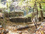
Industry
Iron mining and smelting once took place along the upper reaches of Popolopen Creek. The Forest of Dean Mine produced iron ore from the RevolutionAmerican Revolution
The American Revolution was the political upheaval during the last half of the 18th century in which thirteen colonies in North America joined together to break free from the British Empire, combining to become the United States of America...
ary era into the twentieth century, operating a narrow gauge
Narrow gauge
A narrow gauge railway is a railway that has a track gauge narrower than the of standard gauge railways. Most existing narrow gauge railways have gauges of between and .- Overview :...
railroad along the creek as far as the eastern slopes of Popolopen Torne. The mine site is now submerged under Stillwell Lake. Queensboro Furnace, located just above the outlet of Queensboro Brook into the creek, smelted iron during the late eighteenth century. The remains of the furnace have been preserved but are located on the grounds of the West Point Military Reservation.
An aqueduct
Aqueduct
An aqueduct is a water supply or navigable channel constructed to convey water. In modern engineering, the term is used for any system of pipes, ditches, canals, tunnels, and other structures used for this purpose....
was built on the north side of the gorge in 1906 to bring water from Queensboro Brook and Popolopen Creek to West Point. Another was built on the south side in 1929–30 to supply Bear Mountain State Park with water from Queensboro Lake. Repairs to the latter were to result in the closing of the combined Popolopen Gorge–1777 West–1779–Timp-Torne Trails from the fall of 2008 to spring 2009.